![]()
![]()
![]()
Clare Oxby
Forest farmers: the transformation of land use and society in eastern Madagascar
Clare Oxby, a social anthropologist at the Overseas Development Institute, UK, recently visited an FAO project in Madagascar in connection with a study on alternatives to shifting cultivation in Africa for FAO's Forestry Department (see References: FAO, 1984, and Oxby, 1983a and b).The practice of hill rice cultivation with the "slash and burn" technique is one among many factors leading to a steady diminishing of Madagascar's eastern forest reserves. The alternative, irrigated rice, not only would help to preserve forests but also appears to be a better economic choice for the farmers themselves. Indeed, there has been a gradual increase in irrigated rice cultivation throughout the region, and an associated change toward a more settled, village-based society. However, the transformation has not been as fast as planners might have expected and, significantly, there has not been any noticeable decrease in the incidence of slash and burn. A closer look shows that there are a variety of good reasons why farmers persist in growing hill rice.
· Among forest farmers in the east coast region of Madagascar, it is traditional to sacrifice an ox the day before clearing forest vegetation in preparation for cultivation. This ceremony is performed by way of atonement for "undressing the tombs of the ancestors"; it demonstrates the farmers' reluctance to destroy the forest unless they have no alternative. Since their ancestors are buried in tombs deep in the forest, there is a strong prohibition against removing any vegetation in the vicinity. Even in largely deforested areas, small groves of primary forest hide the ancestors' tombs. The forest dwellers of eastern Madagascar have a profound respect both for their ancestors and for the forest, which is their main source of household construction materials, fuel, fruit, nuts, game meat and medicines.
The actual process of deforestation in this region is familiar from other parts of the world. Familiar too is the way that blame for deforestation is directed toward small farmers and their "short-sighted" practices. This view not only distracts attention away from other agents of forest destruction and degradation, such I as charcoal burners, fuelwood traders, timber companies and large scale agriculturists operating in forest areas, but also undervalues small farmers' position by failing to take into account the constraints under which they operate and the limited alternatives open to them. Small farmers may indeed be agents of forest destruction, but understanding the causes of deforestation requires looking a little further (Westoby, 1978). Farmers may be unwilling agents, like those mentioned above; moreover, they are easy to blame, since on the whole they do not respond to allegations against them.
This article attempts to explain why small farmers continue to practice an extensive form of fallow farming known as tavy, a term better translated as "slash and burn" than "shifting cultivation", since it refers to a technique of clearing vegetation in preparation for cultivation that may be applied even when the fallow period is reduced to as little as two years, and when house sites are permanent. Small farmers are often reluctant to abandon tavy in favour of more intensive forms of land cultivation such as irrigated rice. Such a switch, it is believed, would relieve the pressure on the remaining forest, halt soil erosion and degradation, and enable farmers to produce a surplus which would help to raise their incomes and feed the urban areas, which at present are obliged to depend on imported food.
The reasons why such an apparently advantageous change is not taking place as fast as planners had expected are instructive. They are particularly instructive to foresters, since the slash-and-burn technique is one of the immediate causes of deforestation in the tropics. The annual rate of primary forest destruction in Madagascar has been estimated at 165000 ha (FAO, 1981); and the annual production of hill rice with the slash-and-burn method at 60000 to 80000 tonnes (Ratovoson, 1979).
These figures are nationwide, I but the largest concentration of forests, as well as the main area of hill rice production, is in the east coast region. The transformation of land use from forest to farm is gradual: the ancestors of the irrigated-rice cultivators of the central plateau area of Madagascar were hill rice cultivators several centuries ago, when the area was covered by forest. Gradually, as the forest was destroyed, they turned to irrigated agriculture. In some cases, people were pushed back into the forest as a result of wars and reverted to hill rice cultivation (Bloch, 1975).
Instructive also is the social transformation, from a sparse population of forest dwellers living in semi-permanent settlements whose social organization is relatively egalitarian, to a village-based society characterized by higher population densities and a more hierarchical social structure. These parallel changes in land use and society are important in understanding the farmers' choice of agricultural strategy.
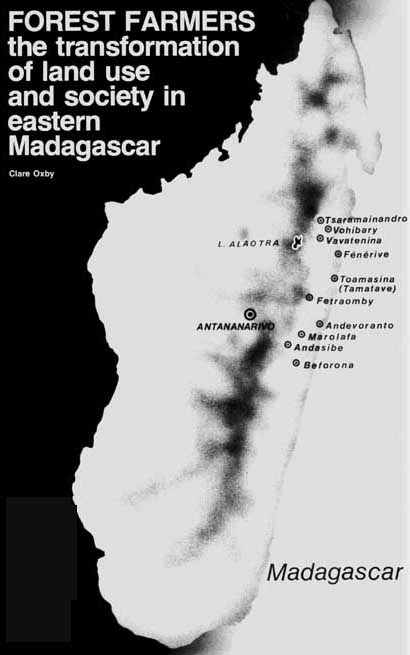
Less than 100 km wide but about 1000 km long is a stretch of mountainous, forest-covered land known as the east coast region of Madagascar. It rises from the sea through a series of escarpments to the edges of the central plateau at a height of over 1000 m. Eastern winds bring year-round rain. The annual average is 3000 mm on the coast at Toamasina and 2200 mm inland at Vavatenina. Tropical forest thrives in this warm and damp climate. At one time the entire area was covered by rain forest, including even the present-day coastal swamps (as attested by fossil remains). Today most of the narrow coastal plains and the lower slopes have been deforested, but some two-thirds of the region, particularly the higher slopes, is still covered by primary forest. This forest is quite unique, since about 90 percent of the tree species therein are found only in Madagascar.
Flying between the highland capital Antananarivo and the east coast during the cultivation season, one can observe the entire progression from forest to agricultural plain. Leaving the deforested central plateau region, one passes over the edge of the escarpment and down its densely forested higher slopes. The deep-green forest cover extends ahead and on both sides as far as the horizon, interrupted only by rocky outbursts, shiny rivers, and the two lines of communication - the railway, and the road, which is usually impassable at this time of year. Along them are concentrated tiny, cleared patches of paler-green vegetation, representing hill rice fields, or forest regrowth (known as savoka in Malagasy).
Further down the escarpment, the forest is interrupted by bright-green river valleys; this is irrigated rice cultivation. As the plane approaches the coast, there is a sudden increase in the number of cleared areas, areas now either under cultivation or under fallow vegetation. The deep-green patches of high forest become scarce. Along the narrow coastal strip can be seen, between the villages and towns, ordered plantations, irrigated rice fields and some green-gray "exhausted" areas of degraded vegetation. Such an air trip illustrates the gradual process of deforestation and concentrates in half an hour what has happened over centuries.
At ground level, forests are first selectively felled by timber companies, who remove the most valuable trees for sale on the international markets. The remaining trees are exploited for railway sleepers and fuelwood through local marketing networks. Sections of the remaining forest vegetation are then burnt and cleared, either by plantation wage labourers, who also plant trees in the cleared area, or by independent farmers, who prepare the area for hill rice cultivation according to the tavy slash-and-burn technique, which uses the ashes from burnt woody vegetation to fertilize the soil in preparation for cultivation.
IRRIGATED RICE (below) HILL RICE (above) a complex choice
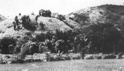
In the densely forested areas of the upper slopes, away from the main lines of communication, hill rice is interplanted with maize and often beans during the first cultivation season, and is sometimes followed the next year by a crop of cassava. The land is then left for a six-to-ten-year fallow period, after which the process is repeated. When high forest is cleared, rice is usually grown consecutively for two years. Yields may be higher in the second year, since some of the thicker branches escape the fire and take some time to decompose (Dandoy, 1973). Cassava is planted last, as it thrives on poorer soils.
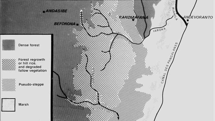
Population densities in such areas are low; but as one approaches the deforested areas of the coast, they gradually rise: from 5 inhabitants per km2 in Andasibe district to 10 in Ranomafana district and 41 in Andevoranto district on the coast. Where there is population pressure and a shortage of fertile land as occurs in deforested areas on the lower slopes, around the irrigated valleys, and to a certain extent along the road and the railway - it is no longer possible to leave sufficiently long periods of fallow. The fallow vegetation is thus cleared for farming before the forest regrowth has had time to establish itself and regenerate soil fertility. The six-to-ten-year fallow period is thereby reduced to five, three and - in some cases - only two years. If the land is repeatedly cultivated after such short periods of fallow, the result is a degraded fallow vegetation characterized by an absence of valuable species and often dominated by a single species like bamboo, or ravenala (in French, l'arbre du voyageur).
A trend of soil degradation and decreasing yields sets in which is difficult to reverse without a radical change in farming technique, often requiring much capital and labour investment. Along the coast can be seen areas of degraded vegetation, which the farmers have abandoned to move nearer the forest. The techniques of hill rice cultivation are not in themselves responsible: it is when such techniques are applied too frequently on the same piece of land that soil degradation occurs.
East coast forest farmers generally practice a complex farming system. There are three kinds of land cultivation: tsabo, or perennial agricultural crop cultivation; horaka, or wet rice cultivation; and tavy, or hill rice cultivation. Most households practice all three techniques at the same time. Coffee became widespread in the 1910s, and cloves in the 1930s (Dandoy, 1973). Both remain an important source of household income, which is used to hire agricultural wage labour and to buy clothes and hardware and, in times of shortage, food.
Wet rice cultivation is not a recent introduction: it was reported by eighteenth-century travelers. However, irrigation technologies and the associated use of the plough were introduced into the region only in the last century. The surface area under wet rice cultivation has gradually increased, especially in areas of growing population density. However, this has not been associated with a decrease in hill rice cultivation.
As a means of maximizing rice production and coping with increasing rates of population growth (3-3.5 percent annually), and despite certain constraints on the development of wet rice cultivation which will be discussed below, slash-and-burn agriculture has remained the most important technique for producing food in the region. Twice as much hill rice as wet rice is produced in the region (Le Bourdiec, 1974); most people there agree that the species grown on the slopes taste better than those grown in the swamps, and hill rice is still regarded as the local staple food. Because of difficulty of access to land, the main trend has been toward a gradual reduction of the fallow period, with severe consequences for the regeneration of soil fertility. However, up-to-date regional figures would be necessary to document these trends more precisely.
Slash-and-burn agriculture has remained the most important technique for producing food in the region.It is necessary to go beyond economic calculations of rice yields in order to understand why people continue to practice hill rice cultivation.
Meanwhile, the east coast region is not self-sufficient in rice, and in many areas there are chronic shortages. Rice needs are satisfied on average during nine months of the year. During the remaining three months, other food crops like cassava and bananas help to bridge the gap until the next rice harvest. Moreover, severe marketing and distribution problems mean that rice is not always available to buy during this time.
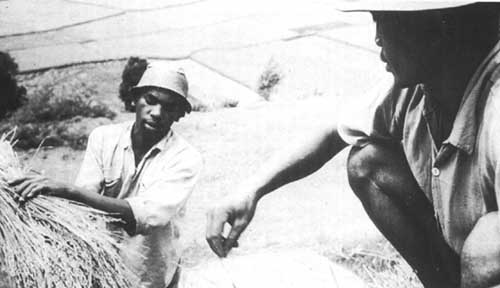
In terms of rice yields per hectare, it is clear that wet rice is more productive than hill rice, as the table shows. As for the returns to labour (most work-days are woman-days, not man-days), the results are not so clear. According to Le Bourdiec, hill rice takes less work than wet rice; SECMO and Dandoy claim the opposite. Perhaps the difference can be accounted for by the fact that Le Bourdiec includes time for canal maintenance, whereas it is not clear whether the other sources do. In this case, Le Bourdiec's would be the more reliable figures. In a comparison of yields from hill and wet rice cultivation, however, the utility of a per-hectare measurement must be in doubt. Whereas new land is generally available for hill rice production, access to suitable land is a major constraint on the production of irrigated rice and may therefore limit producers' performance. Again, hill rice requires much more land than is actually under cultivation in any one season: if the area under fallow as well as that under cultivation were taken into account, the resulting yields would be ridiculously low. These points only strengthen the argument that wet rice is a more rational choice for the farmer than hill rice.
However, a closer scrutiny of what is being measured, and how, points to a less definite conclusion. Since hill rice is usually cultivated in association with maize and often also with beans and cassava, to measure yields in terms of only rice is to underestimate productivity by a considerable amount. Also, clearing forest vegetation involves cutting wood, some of which is used in home construction or as fuelwood and some of which may be sold as railway sleepers, fuelwood or charcoal. None of this is taken into account in the above figures. The figures may also ignore not only the time required to maintain the irrigation infrastructure, as seen above, but also the time needed to construct it in the first place. In the mountainous areas of the east coast, where swampland and flat land generally occur in small, isolated tracts, the time involved can be considerable. Moreover, whereas irrigated fields require a certain amount of supervision and maintenance even outside the cultivation season, hill rice cultivation releases all workers completely in the off season so that they can seek seasonal wage work.
Perhaps most important is the fact that the figures relate to areas where hill rice production is in crisis because of rising population densities, increasingly difficult access to land, and consequently decreasing fallow periods. Dandoy, who records the highest yields, specifically chose to carry out his surveys in the Vavatenina region because it was a crisis area: of the 13 villages he studied, only one managed to satisfy its rice needs. This is also one of the most densely populated areas of the east coast, having experienced a sudden 50 percent increase in population density between 1955 and 1966 (from 14 to 21 inhabitants per km2). In 1966, one-quarter of the farmers of Vohibary had to leave village land to find areas to clear and farm because of land shortage.
Unfortunately, it was impossible to locate any comparable figures for hill rice production in the more densely forested areas. The returns to labour are likely to be higher, for the following reason: weeding, which is one of the main tasks in Vavatenina, is much less of a problem when cultivation follows the clearing of primary forest or forest regrowth of a certain age.
It is thus difficult to draw any firm conclusions on the relative yields of hill and wet rice in the east coast region. The returns to labour from hill rice cultivation are probably lower in most cases - especially in the crisis areas of land shortage and shortened fallows - but not as low, in relation to irrigated rice, as the figures suggest. But if the returns to labour are lower, why do farmers continue to practice tavy?
Labour input and crop yield from hill rice and wet rice cultivation in the east coast region of Madagascar
|
Location |
Hill rice |
Wet rice |
Reference |
||
|
Labour input (work-days per ha) |
Yield (kg per ha) |
Labour input (work-days per ha) |
Yield (kg per ha) |
||
|
Vavatenina (Tsaramainandro) |
82 |
700 |
54 |
1200-1500 |
FAO project staff, personal communication; SECMO. 1980 |
|
Betsimisaraka region |
100 (of which 50 on clearing vegetation) |
800 |
150 |
<2000 |
Le Bourdiec, 1974 |
|
Vavatenina (Vohibary) |
244 (of which 158 on bird-scaring) |
970 (400-1730) |
157 |
2200 |
Dandoy, 1973 |
|
Tamatave province |
- |
620 |
- |
1330 |
Chabrolin, 1965 |
One explanation for farmers' failure to adapt irrigated rice cultivation more rapidly that should be ruled out at an early stage is ignorance: many farmers, in fact, practice both cultivation techniques every year, in addition to tending their agricultural cash crops and vegetable plots. They are clearly in the best position to compare the different cultivation techniques, being intimately aware of the effects of the cultivation of different crops on different types of soil, which they judge according to the type of growth of wild species (Dandoy, 1973). There are various topographical, technological, sociological, economic and political reasons why small farmers in the east coast region continue to practice hill rice cultivation despite low and variable yields.
Topographical In mountainous regions like the east coast of Madagascar, land suitable for swamp or irrigated rice cultivation, using techniques accessible to small farmers, is not always easy to find. The most desirable land has, frequently, already been claimed (though not necessarily exploited). Although there is still plenty of irrigable land in Tanala country in the south of the east coast region, many of the suitable areas in Betsimisaraka country to the north pose particular problems because they are narrow, isolated valleys and are subject to drainage problems (Le Bourdiec, 1974).
In Vohibary, for example, 4 ha were irrigated but there was a total of only 10 ha of irrigable land available. In some neighbouring villages, all irrigable land had already been used, or else there was no suitable land available, given that major labour and capital investments for constructing terraces and canals were beyond the capabilities of local farmers. As a result, a survey of 13 neighbouring villages, including Vohibary, demonstrated a complete contrast in agricultural techniques: two practiced only wet rice and no tavy; four practiced only tavy and no wet rice; and the remaining seven, including Vohibary, practiced varying combinations of tavy and wet rice. Such variations should be understood primarily in terms of topography, and correspond to three different types of localities: a long but narrow swamp, the plain of lazafo; the forest-covered hills; and, finally, the forest margins (Dandoy, 1973).
Tenurial Parallel to the differences in natural environment between areas of limitless high forest on the upper slopes of the escarpment and areas of intense cultivation and degraded forest fallow on the lower slopes, there are important differences in social relations within the communities living there. Among the Zafimaniry, for example, who live in small groups in the forest, there is relatively little differentiation of wealth between households.
Access to land is easy, and the main constraint to production is the lack of labour to clear the forest and cultivate the land (Bloch. 1975).
HILL RICE IN MADAGASCAR pressure on the forest
Lower down the slopes, in areas like Vavatenina, where population densities are higher, where large surfaces have been planted in perennial crops for export, where remaining areas of primary forest are scarce and remote, and where fallow periods are shortened and cultivation repeated frequently on the same spot, access to land becomes an important constraint. A recurrent topic of conversation, in contrast to the situation in the forest villages, is therefore the access to and inheritance of land. There is a rush to establish rights to land: either by clearing it, which gives temporary use rights; or by planting perennial crops like coffee or cloves, which gives more permanent rights of ownership; or by getting the land formally registered as private property by the local administration, which is a long and complicated process (it frequently takes 15 years), and small farmers are at a disadvantage in following it through. Large tracts of land have been privatized in this way, usually for large-scale crop cultivation. In some cases, privately owned land may be left fallow on a permanent basis, and small farmers may be denied use rights (SECMO, 1980). One attempt to improve wet rice cultivation and discourage tavy at Marolafa near Beforona has been severely hampered by problems of land tenure (Benoit de Coignac et al., 1973; Oxby. 1983a).
There are considerable differences in the desirability of different types of land, and irrigated land is at a premium. Those who are established on such land and manage to get it registered in their own name find themselves in a position of great advantage. This advantage increases as population pressure and land shortage grow. Farmers with insufficient fertile land may have to resort to working as wage labourers for the larger landowners for part of the year, in order to supplement their meagre rice harvest. There is social stigma attached to such wage labouring, and farmers go to neighbouring villages to do it, not their own. Some land is rented out by the larger landowners, and there develops a class of landless tenant farmers. Given this situation, leaving the village for a more forested area in order to practice hill rice cultivation may represent an attractive alternative to tenant farming or wage labouring. In a comparison of hill rice and irrigated rice, the relevant figure for many farmers is not the yields from hill rice farms, but the amount of irrigated rice received according to the share-cropping arrangement between tenant farmers and landowners, or else the amount of rice that can be bought with a daily wage, if indeed there is rice available to buy.
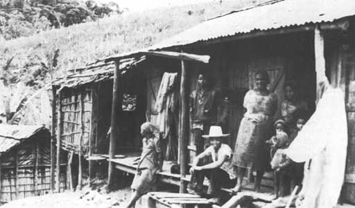
HILL RICE GROWERS NEAR ANDASIBE with untouched forest in background
Administrative A full discussion of the constraints to the intensification of agriculture cannot omit reference to the political relations between the hill farmers and those whom they group together as vazaha (outsiders). The vazaha include the local agents of the central authorities, of private enterprise, of foreign investment and of international aid.
Despite the lack of communications in the forest areas - the main way of traveling is still on foot - all of the villages there grow at least some cash crops, pay taxes and participate to some degree in the national economy. This is the result of a gradual social transformation over a long period of history. The French colonized the island of Madagascar in 1895, and their administration was imposed on the east coast and other areas in the early twentieth century. In the early nineteenth century, the forest areas of the east coast had been conquered by the Merina kingdom of the central plateau area of Madagascar. Before that, in the seventeenth and eighteenth centuries, the establishment of Arab, Dutch, French and British trading posts along the east coast made its impact on the local population. Forest products like wood, raffia, rubber and beeswax and gold and other minerals were sought after, and tracks through the forest represented the main trading link between the coastal settlers and the civilization of the plateau region. Forest villages represented a source of labour for obtaining forest products and for porterage between highland settlements and coastal trading posts.
The nineteenth and twentieth centuries have seen increasing control of the east coast area by vazaha. This has taken the form of tax collection, efforts to ban the cutting of forest for hill rice plantations, and attempts at controlling agriculture, in particular the strong discouragement of hill rice and encouragement of perennial crops for export.
The following example of a ban on cutting down forests for rice production is taken from the legal code of Queen Ranavalona II, issued in 1881:
The forest may not be cleared by fire with the aim of establishing fields of rice maize or any other crops; only those parts previously cleared and burnt may be cultivated; any persons effecting new clearings by fire or extending those already in existence shall be clapped in irons for five years. (Quoted in the original French in Uhart, 1962)
Afterwards, during the colonial administration, permission to clear forests for tavy was generally given only when taxes had been paid (Althabe, 1969); moreover, punishments were imposed for "illegally" cutting down the forest, with a penalty of either a fine or an obligation to plant trees (Ratovoson, 1979). Remembering this, the reaction today of some local farmers, upon being asked to plant trees, is: "What have I done wrong?" However, by 1975, the area for which permits to clear forest vegetation had been granted, which had steadily diminished during the period 1960-69, had nearly doubled to 193500 ha (Ramamonjisoa, 1983).
Forests, like mountains, are places that centralized administrations find particularly difficult to govern. Because of the low population densities and lack of communications characteristic of such areas, communities may remain largely autonomous. In some cases, the lack of detailed local knowledge on the part of the authorities facilitates this autonomy. The east coast region of Madagascar is both mountainous and forested. Not surprisingly, therefore, the region has a strong history of resistance.
Elaborate controls were introduced in the east coast region in 1935-40, when every household head was obliged by the colonial government to plant a certain number of perennial cash crops, coffee or cloves, under the supervision of local administrators. At the same time, many concessions were granted by the government to settlers, who established plantations in the region. In the agitated political atmosphere of repeated election campaigns after 1945, towns and army barracks in the central part of the east coast region were attacked in 1947 by armed groups of several hundred men. This escalated into a rebellion which spread to other parts of Madagascar. By 1948, it had been quelled by force, and thousands were killed. There followed a period of fierce reprisals and many years of redoubled control, taking the form of forced labour to construct roads and buildings. Laws against cutting down primary forest were enforced with renewed vigour, and offenders were punished.
Such experiences are not quickly forgotten. Althabe (1969) describes a society in the east coast region that is split. On the one hand is the façade presented to outsiders, who are allowed but a partial view of village life. They see the "village on the road" - the permanent houses, the permanent vegetable and fruit gardens, the permanent rice fields and the perennial agricultural crops. On the other hand, what outsiders are not shown, and what they are discouraged from seeing, is the other side of village life - the rice fields some distance away in the forested hills, the temporary houses constructed there every year, the feasts and ceremonies (closely linked to hill rice production) that are practiced there, and the herds of cattle that live in the hills and provide the oxen to be sacrificed during these ceremonies. Althabe observed a strict and symbolic distinction between the European type of clothing worn in the "village on the road" - in the wet rice fields and cash-crop fields and at the market and the traditional bark-cloth clothes worn in the tavy. He also observed a spirit-possession cult - a recent development and not an ancestral cult which reinforces this distinction.
All this is to stress how important is the villagers' perception of subordination to the various central authorities of different times, and to explain why it is necessary to go beyond economic calculations of rice yields in order to understand why they continue to practice hill rice cultivation. Part of the attraction of tavy - and the ways of thinking and living that go with it is the relative freedom of decision-making it gives to individual producers. This is in strong contrast with the regulation and supervision associated with the cultivation of wet rice and perennial crops.
The straightforward question that was asked at the outset - why do farmers not turn to a more productive form of rice cultivation? - thus has a many-faceted answer: farmers are gradually changing their techniques of rice cultivation and turning from hill rice to wet rice in response to changing circumstances, but there are important constraints. There is in many places a scarcity of land suitable for wet rice cultivation with irrigation technologies that are accessible to small farmers. This is compounded by strong inequalities within communities in access to that land. Those who lack access to suitable land find themselves in a dilemma: either they go to work for landowners and share the harvest with them, or they choose autonomy by moving to a forested area. Otherwise, they may practice a combination of both irrigated and hill rice cultivation. Hill rice farmers in the forest may be isolated and suffer from lack of services, distance from markets and the need to work harder, but at least they enjoy more freedom and independence in their work. It is for these reasons that the new technologies, and the hierarchical society that goes with them, may not be accepted - especially if farmers must enter this society as tenant farmers or wage labourers.
What about the longer term, when the forests run out? The high rates of deforestation may be impressive; but so are the vast expanses of forest that remain in the east coast region of Madagascar, as anyone who has travelled in the area will agree. The policies of the central authorities may have seemed somewhat contradictory to forest farmers, especially during colonial times: farmers were discouraged from cutting down the forest for their own farms, yet at the same time they were encouraged to cut it down to plant export crops and to establish forest plantations. If the forest is going to be cut in order to establish a large coffee plantation for a new settler from overseas, why should it not also be cut so that they can grow their own rice?
What are the implications of this analysis for development plans in the region? A number of improvements can be suggested. Detailed topographical surveys, for example, are needed to indicate areas where capital outlay beyond the capabilities of local farmers might enable the land to be cultivated more intensively. Any technological changes undertaken should be monitored very carefully so that benefits go to poorer farmers who would otherwise rely on tavy, than to wealthy farmers who do not practice tavy anyway. In areas where there is no land suitable for wet rice cultivation or where irrigation has yet to be developed, it is unthinkable to prevent farmers from clearing forest in order to plant food crops for their own subsistence needs. In this case, it would be desirable to concentrate on improving hill rice yields, for example by introducing agroforestry techniques. The hope would be for contact between local authorities and farmers to be as egalitarian as possible so that the technical knowledge farmers have of their own regions is valued and put to good use.
Where wet rice cultivation is already practiced, farmers could be encouraged to make more use of oxen and to grow a second crop. Moreover, in order to compensate for the fact that several crops may be grown together with hill rice, thus giving it a certain advantage over wet rice, it might be desirable to encourage the cultivation of several food crops, such as cassava and sweet potatoes, on ridges (Trinh Ton That, personal communication). Care should be taken, however, to ensure that the labour requirements of these improvements are compatible with those of other agricultural activities. In the past this has proved a major problem which has sometimes been overlooked by planners (Le Bourdiec, 1974).
Any analysis of deforestation has to go deeper than establishing how many trees are cut and who cuts them. It has to ask why they are cut, and what the alternatives are. It must recognize that the immediate agents of deforestation the people who cut down trees - do not necessarily like what they are doing, but find re doing, but find themselves in a situation where it is their best strategy for decent survival.
ALTHABE G. 1969, Oppression et libération dans l'imagination. Les communautés villageoises de la côte orientale de Madagascar. Paris, Maspéro.
BENOIT DE COIGNAC. 1973, G. et al. Essai d'aménagement des terres dans la zone forestière de rest de Madagascar. Bois et forêts des tropiques, 152.
BLOCH. 1975, M. Property and the end of affinity. In M. Bloch, ed. Marxist analyses and social anthropology. London, Malaby Press.
CHABROLIN, R. 1965, La riziculture de tavy 3 Madagascar. Agronomie tropicale, 20.
DANDOY, G. 1973, Terroirs et economies villageoises de la region de Vavatenina (côte orientale malgaghe). In Atlas des structures agraires à Madagascar, 1. Paris, ORSTOM.
FAO. 1981, Tropical Forest Resources Assessment Project: Forest resources of tropical Africa. Part 1: Regional synthesis. Part II: Country studies. Rome, FAO.
FAO. 1984, Changes in shifting cultivation in Africa. FAO Forestry Paper 50. Rome.
LE BOURDIEC, F. 1974, Hommes et paysages du riz à Madagascar: etude de géographie humaine. Madagascar, Geography Laboratory of Tananarive.
OXBY, C. 1983a, Alternatives and improvements to shifting cultivation on the east coast of Madagascar: socio-economic aspects. Report prepared for FAO Forestry Department. Rome. (Mimeograph.)
OXBY, C. 1983b, Should shifting cultivators take the blame? A summary of research findings on socioeconomic aspects of shifting cultivation in Africa. Paper presented at the Technical Consultation on the Education, Training and Extension Aspects of Shifting Cultivation, Rome, 12-16 December 1983. Rome, FAO.
RAMAMONJISOA, J. 1983, Les aménagements malgaches dans le domaine des aménagements rizicoles. Paper presented at the conference Développement agricole et participation paysanne, held at the Centre d'études juridiques comparatives, Paris 14-15 October 1983.
RATOVOSON, C. 1979, Les problèmes du tavy sur la côte est malgache. Madagascar Revue de geographic, 35.
SECMO. 1980, Restauration et mise en valeur des savoka: étude socio-économique. 4 vols. Madagascar, Société des études et de la construction des maisons et des ouvrages.
UHART, E. 1962, Le problème forestier à Madagascar. Cahiers de l'Institut de science économique appliquée. Développement, croissance, progrès, 121, Series F. No. 17.
WESTOBY, J. 1978, Forest industries for socio-economic development. Paper presented at the World Forestry Congress, Jakarta.
![]()
![]()
![]()