![]()
![]()
![]()
by
B. Chang and H. Martínez
Dept. de Recursos Naturales Renovables
CATIE, Turrialba
Costa Rica.
BACKGROUND
About 1,500 million people use wood for heating and cooking in the developing countries (Arnold, 1978). Central America is among the regions concerned: approximately 80% of the wood cut is used as fuelwood by about 15 million people (72% of the population). The proportion of total energy consumption provided by fuelwood varies from 26% in Panama to 64% in Honduras which, with Guatemala and El Salvador, has the highest rate of fuelwood consumption (Martínez, Bauer and Jones, 1968).
In Central America, with a population growth of about 2.7% per year and high costs of electricity and petroleum imports, there are no signs of any major decrease in the demand for fuelwood in the coming years.
The region's natural fuelwood sources are native conifer forests, mixed conifer and Quercus spp. forests, mixed hardwood forests, pioneer species and secondary forest in areas with a seasonal rainfall; also material from crop residues, community plantations and live fences. In secondary forests at low and intermediate altitude in some countries in Central America, Calliandra calothyrsus Meissn. is especially important as a producer of medium-sized fuelwood.
NATURAL DISTRIBUTION
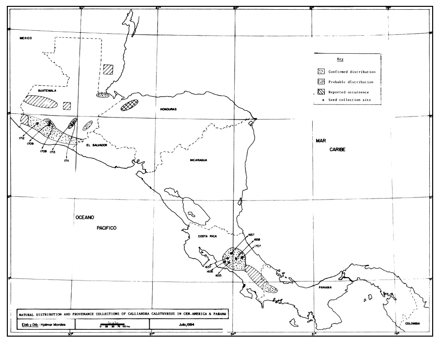
C. calothyrsus is a native species growing from southern Mexico to north-western Panama (NAS, 1983). In view of the performance of this species in Indonesia, grown from Guatemalan seed (NAS, 1979), it was decided to identify the most promising sources for the development of energy plantations (See Figure 1).
Field reconnaissance confirmed the existence and distribution of the species in a large part of Central America. In Guatemala it is found on a strip located between 14°14' and 14°52' north latitude and between 90°00' and 91°34' west longitude (Santa María de Jesús, Quezaltenango and Oratorio), between 400 and 1,600 m.a.s.l. with 1,200 to 3,000 mm annual average rainfall and a dry season of 2 to 4 months; in a small area between 14°45' and 14°50' north latitude and between 89°55' and 90°20' longitude, around Sanarate, El Progreso, between 700 and 900 m.a.s.l., with 700 to 850 mm annual rainfall and a seven-month dry season; and also at the eastern end of the country in Esquipulas at 14°45' north latitude and 85°28' west longitude, 1,300 m.a.s.l. with a five-month dry season.
In Costa Rica occurrence of the species has been confirmed in the Puriscal area (9°45' to 9°52' north latitude, 84°12' to 84°25' west longitude, 900 to 1,100 m.a.s.l., average annual rainfall 2,500 mm and a four-month dry season); in Birrí de Heredia (10°04' north latitude and 84°08' west longitude, 1,300 m.a.s.l., average annual rainfall 3,000 mm and a dry season of one month); Tejar en Cartago (9°50' to 9°52' north latitude and 83°56' to 85°57' west longitude, 1,300 m.a.s.l., annual rainfall 1,500 mm and a dry season of four months), and Turrialba (9°55' to 9°56' north latitude and 83°41' to 83°43' longitude, 600 to 900 m.a.s.l., rainfall 2,500 mm and one dry month).
In Panama the species is found in the Bajo Boquete, Chiriquí area at 8°46' north latitude, 82°27' west longitude, 1,200 m.a.s.l., with 3,000 mm annual rainfall and a dry season from one to two months.
The species has been reported tentatively as occurring in north west Honduras (15°30' north latitude and 88°17' west longitude, 600 m.a.s.l., 1,600 mm annual rainfall and a four-month dry season). Reconnaissance work is also needed in El Salvador and Nicaragua.
PHENOLOGICAL OBSERVATIONS
In the Central American area the species flowers between September and November, although flowers can be found in December. Fruiting extends from November to early January and seed is harvested in January, although mature fruits can sometimes be found in the second half of December.
In the dry season the tree is semi-deciduous. Die back occurs in severe dry seasons with subsequent recovery at the beginning of the rainy season. The species is an aggressive colonizer, possibly because it produces prolific seed crops.
LOCATION OF SEED PRODUCING STANDS
Seed collection areas cover practically the whole natural range of C. calothyrsus in Central America. In 1984 seed was harvested in almost all known stands, except in Panama where it is hoped that collection will be carried out next January. Seed was collected from more than 260 trees representing 11 provenances, with a minimum of 20 randomly distributed trees per stand (see Table 1. and map).
EVALUATION OF PROVENANCES
Since the provenances identified cover a wide geographic area characterised by wide ecological variation (for example, the dry season fluctuates between one and seven months, soil from fertile to eroded, average precipitation from 700 to 3,000 mm annually and altitude from 700 to 1,600 m.a.s.l.) it is hoped that the collection of seed samples from this wide range will be followed by provenance trials in order that the potentially useful variability and the adaptability of the species to a range of environmental conditions can be fully assessed (Palmberg, 1980).
It is proposed that provenance trials be conducted in the immediate future on sites representative of a range of ecological conditions (altitude, latitude, longitude, precipitation, soils)1, and that at the same time steps be taken for in situ conservation of productive stands. At a later stage larger collections of seed should be carried out of provenances of greater potential for the establishment of ex situ stands.
FUTURE RESEARCH
In addition to implementation of a regional provenance trial, we intend:
To expand the number of provenance collection sites.
It is proposed that seed from additional identified sites in Central America be collected to increase the number of provenances to be tested, i.e. two more natural sources in Guatemala, one Guatemalan stand derived from seed from an Indonesian plantation, itself grown from seed of Guatemalan origin, one/two in Honduras and one in Panama. We also hope to increase the quantities of seed from previous collection sites to at least 1 kg/provenance.
To conserve natural stands.
In collaboration with national forest services and private landowners, it is proposed to demarcate and conserve in situ earlier identified natural stands (FAO, 1981) so as to eliminate the possibility of their destruction by burning, cutting, changes in land use or shifting cultivation.
BIBLIOGRAPHY
1. Arnold, J.E.M., 1978. Wood energy and rural communities. In World Forestry Congress, 8th. Jakarta, Indonesia. 1978
2. FAO, 1981. Report on the FAO/UNEP expert consultation on in situ conservation of forest genetic resources, Rome, 2–4 December 1980. FAO, Rome, 34 pp.
3. Martínez, H., Bauer, J., and Jones, J. 1983. Fuelwood in Central America and the regional fuelwood and alternative energy sources project. Turrialba, Costa Rica, CATIE. 16 pp.
4. National Academy of Sciences, 1983. Calliandra a versatile small tree for the humid tropics. Washington, D.C. NAS. 52 pp.
5. NAS., 1979. Tropical legumes: resources for the future. Washington, D.C. 197 pp.
6. Palmberg, C., 1980. Principios y estrategia para el mejor aprovechamineto de los recursos genéticos forestales. In Curso sobre Mejora genética de los árboles forestales. Mérida, Venezuela, 1980. Roma, FAO, Estudio FAO Montes No.20 pp. 27–50.
Table 1. DETAILS OF PROVENANCE COLLECTIONS OF CALLIANDRA
| BLSF Lot No. | PROVENANCE LOCALITY | LAT. | LON. | ALT. | MEAN ANNUAL RAINFALL | DRY MONTHS | SOIL | SEED VIABILITY 10 g | AMOUNT AVAILABLE |
| 1708 | San Lucas, Sololá Guatemala | 14°40'W | 91°06'W | 1600m | 2000 mm | 3 | Deep, volcanic, sandy, loam | 94 | 460 g. |
| 1709 | Patulul, Zuchitepeque, Guatemala | 14°36'N | 91°06'W | 1300m | 1700 mm | 3 | idem | 92 | 225 g. |
| 17111 | Km 34 Sanarate, El Progreso, Guatemala | 14°47'N | 90°17'W | 850m | 850 mm | 7 | Shallow, metamorphic, sandy clay | 102 | 260 g. |
| 1712 | Sta. María de Jesús, Quetzaltenango, Guat. | 14°43'N | 91°32'W | 1500m | 3000 mm | 2 | Deep, volcanic, sandy loam | 98 | 430 g. |
| 17131 | Km 51 1/2 al Atlántico El Progreso, Guat. | 14°47'N | 90°15'W | 900m | 700 mm | 7 | Shallow, metamorphic, sandy clay | 104 | 375 g. |
| 1637 | Quitirrisí, Puriscal, Costa Rica | 9°52'N | 84°15'N | 1200m | 2500 mm | 3 | Deep, clayey, crumbling, latosol | 104 | 275 g. |
| 1655 | Palmichal, Puriscal, Costa Rica | 9°45'N | 84°12'W | 1000m | 2100 mm | 3 | Fertile alluvium | 118 | 500 g. |
| 1656 | Salistral, Puriscal, Costa Rica | 9°48'N | 84°25'W | 900m | 2700 mm | 3 | Shallow, eroded, clayey, latosol | 114 | 285 g. |
| 1657 | Birri, Heredia, C.R. | 10°04'N | 84°08'W | 1300m | 3000 mm | 1 | Deep, fertile, volcanic | 120 | 700 g. |
| 1658 | San Isidro del Tejar, Cartago, C.R. | 9°48'N | 83°57'W | 1300m | 1500 mm | 4 | Deep, fertile latosol of volcanic origin | 126 | 450 g. |
| 1707 | Mon Río, Turrialba, C.R. | 9°55'N | 83°42'W | 700m | 2500 mm | 1 | Deep, sandy, alluvium | 95 | 120 g. |
Manuscript received in July 1984
![]()
![]()
![]()