![]()
![]()
![]()
LAKE NAIVASHA
| Geographic data | ||||
| Location: | Kenya - 0° 46'S; 36°22'E | |||
| Altitude: | 1 890 m asl | |||
| Surface area: | 115–150 km2 | |||
| Max. length: | 20 km | |||
| Max. width: | 13 km | |||
| Depth: | 17 m (max); 11 m (mean) | |||
| Seasonal fluctuation in level: 0.5 m | ||||
| Major inflowing river: | Melawa | |||
| Special features: | Closed basin, but fresh water (Burgis & Mavuti, 1987) | |||
| Physical and chemical data | ||||
| Conductivity: | K20 318–400 μ S/cm (Talling & Talling, 1965) | |||
| pH: | 8.8 (Talling & Talling, 1965) | |||
| 9.0 (Beadle, 1932) | ||||
| Ionic composition: | (Talling & Talling, 1965) | |||
| mg/l | mg/l | |||
| Na | 41–45 | Cl | 14.4–16 | |
| K | 21.6–22.6 | SO4 | 2 | |
| Ca | 15.2–21.9 | SiO2 | 31.5–32.5 | |
| Mg | 6.9–7.7 | NO2.N | 32 | |
| HCO3+CO3 | 190.9–209.2 | Total P | 58–122 | |
| Fisheries data | |||||
| Fish species: | indigenous: Aplocheilichthys antinorii introduced: Oreochromis niloticus (main catches); O. spilurus niger; O. leucostictus; Tilapia zillii; Micropterus salmoides (Burgis & Mavuti, 1987) | ||||
| Total annual catch and effort: | |||||
| Year | Total catch (t) | No. of fishermen | No. of boats | Source | |
| 1964 | 550 | - | - | - | |
| 1965 | 55 | - | - | (a) | |
| 1967 | 955 | - | - | (b) | |
| 1968 | 885 | 90 | 16 | (b) | |
| 1969 | 929 | 130 | 16 | (b) | |
| 1974 | - | - | - | ||
| 1975 | 44 | - | - | (b) | |
| 1976 | 78 | - | - | (b) | |
| 1977 | 71 | 16 | - | (b) | |
| 1978 | 255 | - | - | (b) | |
| 1979 | 483 | - | - | (b) | |
| 1980 | 477 | - | - | (b) | |
| 1981 | 269 | - | - | (b) | |
| 1982 | 411 | 80 | 70 | (b) | |
| 1983 | 692 | - | - | (b) | |
| 1984 | 320 | - | - | (b) | |
| 1985 | 245 | 315 | 104 | (b) | |
| 1986 | 576 | 268 | 67 | (b) | |
(a) FAO/UNDP, 1966
(b) Statistical Bulletin, Fisheries Dept., Govt. of Kenya
Potential annual yield: 1 000 t (Welcomme, 1979a)
3 000–4 000 t (FAO/UNDP, 1966)
LAKE NAKURU
| Geographic data | ||||
| Location: | Kenya - 0° 22'S; 36° 5'E | |||
| Altitude: | 1 829 m | |||
| Surface area: | 52 km2 | |||
| Max. length: | 10 km | |||
| Max. width: | 6 km | |||
| Depth: | 0.56 to 4.5 m (max.) | |||
| Major inflowing rivers: | Njoro, Nderit | |||
| Outflow: | None | |||
| Special features: | Highly alkaline | |||
| Physical and chemical data (cited in Burgis & Mavuti, 1987) | ||||
| Temperature: | surface: 25–27°C (mean); bottom: 20–21°C | |||
| pH: | 10.5 | |||
| Conductivity: | extremely variable: 165 000 μ S/cm (1961) to 9 500 μ S/cm (1976) | |||
| Alkalinity: | 5 000–90 000 mg/l | |||
| Ionic composition: | (Hecky & Kilham, 1973) | |||
| mg/l | mg/l | |||
| Na | 3 300 | K | 237 | |
| Mg | 0.9 | Cl | 1 020 | |
| SO4 | 62 | SiO2 | 208 | |
| Alkalinity | 121 meq/l | |||
| Fisheries data: | (Burgis & Mavuti, 1987) | |||
| Fish species: | No fish until the lake was successfully stocked with Oreochromis alcalicus grahamii in 1953, 1959, and again in 1962. See Vareschi (1979, 1982) and Vareschi & Jacobs (1984) for extensive analysis of the biomass, distribution, consumption and role in the ecosystem of this species and for the ecology of Lake Nakuru. | |||
LAKE NATRON
(International water)
| Geographical location | ||||
| Location: | Kenya, Tanzania - 2° 10'–2° 35'S; 36° E | |||
| Altitude: | 610 m (Tuite, 1981) | |||
| Surface area: | 900 km2 (Tuite, 1981) | |||
| Max. length: | 50 km | |||
| Max. width: | 25 km | |||
| Depth: | 0.5 m (max) (Tuite, 1981) | |||
| Special features: | Highly alkaline; no outflow | |||
| Physical and chemical data | ||||
| Ionic composition: | (Guest & Stevens, 1951) | |||
| mg/l | mg/l | |||
| K | 3 000 | SO4 | 3 100 | |
| HCO3+CO3 | 158 600 | SiO2 | 850 | |
| PO4-P | 29 000 μ g/l | Cl | 65 000 | |
| Alkalinity | 2 600 meq/l | |||
| Fisheries data | ||||
| Fish species: | One endemic fish species: Oreochromis alcalicus (Coe, 1969) | |||
LAKE OL BOLOSSAT
| Geographic data | |
| Location: | Kenya |
LAKE TURKANA (RUDOLF)
(International water)
| Geographic data | (see Figure 2) | |||
| Location: | Ethiopia, Kenya - 2° 25'–4° 35'N; 35°50'–36°45'E | |||
| Altitude: | 406 m | |||
| Surface area: | 7 570 km2 | |||
| Max. length: | 240 km | |||
| Max. width: | 44 km | |||
| Depth: | 73 m (max); 29.7 m (mean) | |||
| Volume: | 224.75 km3 | |||
| Shoreline: | 917 km | |||
| Major inflowing rivers: | Omo, Suam-Turkwell | |||
| Physical and chemical data | ||||
| Temperature: | 27.0–28.9°C (surface) | |||
| pH: | 9.3–9.7 | |||
| Conductivity: | 2 860 μ S/cm (Beadle, 1932); | |||
| K20 3 300 μ S/cm (Talling & Talling, 1985) | ||||
| Ionic composition: | (Beadle, 1932) | (Talling & Talling, 1965) | ||
| mg/l | mg/l | |||
| Na | 770 | 810 | ||
| K | 23 | 21 | ||
| Ca | 5 | 5.7 | ||
| Mg | 4 | 3 | ||
| HCO3+CO3 | 1 323.7 | 1 494.5 | ||
| Cl | 429 | 475 | ||
| SO4 | 56 | 64 | ||
| SiO2 | 4.2 | 18 | ||
| Total P | 2 600 | μ g/l | ||
Fisheries data
No. of fish species: 37 (Greenwood, 1964)
Total annual catch and effort: (in Kenya)
| Year | Total catch (t) | No.of fishermen | No.of boats |
| 1964 | 850 | - | - |
| 1965–66 | - | - | - |
| 1967 | 1 727 | - | - |
| 1968 | 2 044 | 1 200 | 30 |
| 1969 | 3 753 | 2 655 | 125 |
| 1970 | 4 000 | - | - |
| 1975 | 4 236 | - | - |
| 1976 | 17 044 | - | - |
| 1977 | 15 473 | - | - |
| 1978 | 15 560 | - | - |
| 1979 | 13 731 | - | - |
| 1980 | 12 384 | - | - |
| 1981 | 10 529 | - | - |
| 1982 | 11 040 | 846 | 282 |
| 1983 | 10 113 | - | - |
| 1984 | 8 448 | - | - |
| 1985 | 7 460 | 785 | 261 |
| 1986 | 7 324 | 783 | 261 |
Source: 1967–1986: Stat. Bull., Fisheries Dept., Govt. of Kenya
| Potential annual yield: | |
| 20 000 t (Balarin, 1985a) | |
| 50 000–160 000 t (FAO/UNDP, 1966) | |
| 5 000–10 000 t (Lake Turkana Investigation Team, 1975) | |
| Note: | Overfishing of tilapia breeding grounds is suspected (Coche & Balarin, 1982) |
| Specific reference: | NORAD, 1980, 1983a,b. |
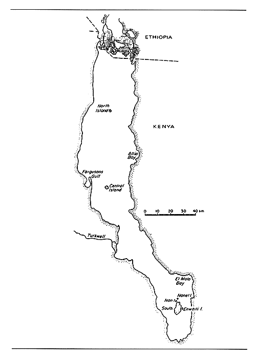
Fig. 2. LAKE RUDOLF - TURKANA
(Welcomme, 1972)
LAKE VICTORIA
(International water)
| Geographic data | (Welcomme, 1972) | ||
| Location: | Kenya, Tanzania, Uganda (see Fig. 3) | ||
| 0° 20'N-3° 0'S; 31° 39'–34° 54'E | |||
| Altitude: | 1 136 m | ||
| Surface area: | Kenya | 4 100 km2 | (6%) |
| Tanzania | 33 700 km2 | (49%) | |
| Uganda | 31 000 km2 | (45%) | |
| Total | 68 800 km2 | ||
| Max. length: | 400 km | ||
| Max. width: | 240 km | ||
| Depth: | 84 m (max); 40 m (mean) | ||
| Shoreline: | 3 440 km | ||
| Catchment area: | 263 000 km2 | ||
| Major inflowing rivers: | Kagera, Nzoia, Yala | ||
| Outflowing river: | Victoria Nile | ||
| Physical and chemical data | ||||
| Temperature: | Surface: 23–28°C | |||
| Dissolved solids: | 97 mg/l | |||
| pH: | Kavirondo Gulf: | 8.2 (Talling & Talling, 1965) | ||
| 9.0 (Graham, 1929) | ||||
| Open lake: | 8.0 (Talling & Talling, 1965) | |||
| 8.5 (Graham, 1929) | ||||
| Conductivity: | K20 91*–98** μ S/cm (EAFRO, 1952*; 1953**) | |||
| Ionic composition: | (EAFRO, 1952a) (Talling & Talling, 1965) | |||
| mg/l | mg/l | |||
| Na | 12.5–13.5 | 10.4 | ||
| K | 3.7–4.2 | 3.8 | ||
| Ca | 5.0–7.0 | 5.6 | ||
| Mg | 2.3–3.5 | 2.6 | ||
| HCO3+CO3 | 61.0–67.1 | 54.9 | ||
| Cl | - | 3.9 | ||
| SO4 | 0.8 | - | ||
| SiO2 | 3–9 | 4.2 | ||
| μ g/l | ||||
| NO3N | - | 11 | ||
| PO4-P | - | 13 | ||
| Total P | - | 47 | ||
Fisheries data
No. of fish species:
177, of which 127 are cichlids (Greenwood, 1964), mostly Haplochromis
species.
Species introduced: in the 1950's: Oreochromis niloticus, O. leucostictus, Tilapia zillii, T. rendalli;
Species introduced: in the late 1950's, early 1960's: Lates niloticus
| Year | Nile Perch % of total catch | |
| 1971 | 0.3 | |
| 1972 | 1.0 | |
| 1973 | 3.0 | |
| 1974 | 5.0 | |
| 1975 | 16.0 | |
| 1982/83 | 30.0 | (TDRI, 1983 estimate) |
It is anticipated that the Nile Perch population will decrease as the Haplochromis stocks become seriously depleted (TDRI, 1983).
Main catches: See Table 5 (Kenya) and Table 6 (total Lake)
Table 5. MAIN CATCHES (KENYA) - LAKE VICTORIA
(after Reynolds & Greboval, 1988)
| Species | 1975 | 1979 | 1985 |
| (t) | (t) | (t) | |
| O. esculentus | 28 | 94 | 42 |
| O. niloticus | 202 | 962 | 7 573 |
| Other tilapia | 412 | 1 683 | 1 827 |
| Bagrus | 1 389 | 1 769 | 61 |
| Lates | 51 | 4 286 | 50 029 |
| Protopterus | 1 469 | 472 | 150 |
| Haplochromis | 4 620 | 6 599 | 6 |
| Clarias | 2 584 | 3 029 | 547 |
| Barbus | 283 | 417 | 113 |
| Synodontis | 126 | 482 | 0 |
| Mormyrus | 58 | 359 | 49 |
| Labeo | 108 | 443 | 0 |
| Schilbe | 54 | 320 | 5 |
| Rastrineobola | 4 548 | 9 321 | 25 866 |
| Other small mixed | 649 | 356 | 2 321 |
| Total | 16 581 | 30 592 | 88 589 |
Sources: CIFA, 1981; DFK Statistical Bulletins; Bwathondi, 1988.
Total annual catch and effort: (in Kenya)
| Year | Total catch (t) | No. of fishermen | No. of boats |
| 1964 | 12 000 | - | - |
| 1965–66 | - | - | - |
| 1967 | 15 748 | - | - |
| 1968 | 16 357 | 6 000 | 4 000 |
| 1969 | 17 442 | 13 600 | 3 600 |
| 1970 | 16 400 | - | - |
| 1971 | 14 918 | - | - |
| 1972 | 15 989 | - | - |
| 1973 | 16 797 | - | - |
| 1974 | 16 258 | - | - |
| 1975 | 17 175 | - | - |
| 1976 | 18 680 | - | - |
| 1977 | 19 332 | - | - |
| 1978 | 23 856 | - | - |
| 1979 | 30 592 | - | - |
| 1980 | 26 914 | - | - |
| 1981 | 38 179 | 18 000 | - |
| 1982 | 60 958 | - | - |
| 1983 | 77 327 | - | - |
| 1984 | 71 854 | - | - |
| 1985 | 88 589 | 21 500 | 5 500 |
| 1986 | 103 163 | 21 000 | 5 000 |
Source: 1967–1986: Stat.Bull, Fisheries Dept., Govt. of Kenya
Potential annual yield: (in Kenya)
25 000 t (Welcomme, 1972)
28 000–40 000 t (FAO/UNDP, 1966)
30 000–45 000 t (Coche & Balarin, 1982)
10 000–26 000 t (Zonneveld, 1983)
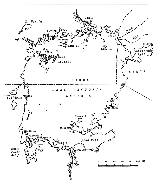
Fig. 3. LAKE VICTORIA
(Welcomme, 1972)
Table 6. TOTAL FISH PRODUCTION IN LAKE VICTORIA, 1975, 1979, 1985
(after Reynolds & Greboval, 1988)
| Species | 1975 | (%) | 1979 | (%) | 1985* | (%) |
| (t) | (t) | (t) | ||||
| O. esculentus | 3 690 | 4.8 | 94 | 2.2 | ||
| O. niloticus | 6 092 | 7.9 | 3 320 | 3.2 | 20 093 | 10.7 |
| Other tilapia | 3 509 | 4.6 | 6 355 | 6.0 | ||
| Bagrus | 10 146 | 13.2 | 13 482 | 12.8 | 9 276 | 4.9 |
| Lates | 301 | 0.4 | 4 476 | 4.3 | 87 637 | 46.7 |
| Protopterus | 7 844 | 10.2 | 6 445 | 6.1 | 4 200 | 2.2 |
| Haplochromis | 22 458 | 29.2 | 29 909 | 28.4 | 11 578 | 6.2 |
| Clarias | 6 382 | 8.3 | 7 917 | 7.5 | 6 107 | 3.3 |
| Barbus | 775 | 1.0 | 1 141 | 1.1 | 515 | 0.3 |
| Synodontis | 2 491 | 3.2 | 7 356 | 7.0 | 9 278 | 4.9 |
| Mormyrus | 178 | 0.2 | 897 | 0.9 | 402 | 0.2 |
| Labeo | 1 719 | 2.2 | 7 332 | 7.0 | 544 | 0.3 |
| Schilbe | 1 069 | 1.4 | 1 958 | 1.9 | 1 582 | 0.8 |
| Rastrineobola** | 4 558 | 5.9 | 10 989 | 10.4 | 25 866 | 13.8 |
| Other small mixed** | 4 707 | 7.4 | 1 419 | 1.3 | 10 417 | 5.6 |
| TOTAL | 76 919 | 105 267 | 187 495 | |||
| Sources: CIFA, 1981; DFK Statistical Bulletins; Bwathondi, 1988. | ||||||
| * Figures for 1985 combine Kenya and Tanzania only. ** Tanzania combines “Rastrineobola” and “Other Small Mixed.” | ||||||
EWASO NGIRO RIVER
| Geographical data | |
| Source: | Mau Escarpment, Kenya |
| Altitude: | 3 124 m |
| Total length: | 200 km |
| Drainage area: | 15 022 km2 |
| Countries traversed: | Kenya |
| Major tributaries: | Engare Siapei; Engare Narok |
| Discharges to: | Lake Natron via Ngare Ngiro Swamp |
| Volume of discharge: | 6.6–63.0 (mean: 22.4) m3/sec; 0.74 km3/yr |
| Flood regime: | Bimodal peaks in flow in April and November |
| Fisheries data | |
| Total annual catch: | 300 t (1965) from Ewaso Ngiro River and Ngare Ngiro Swamp |
GANALE DORYA/JUBA RIVER
(International water)
| Geographical data | |
| Source: | Mendebo Mountains, Ethiopia - 6° 49'N; 38° 41'E |
| Total length: | 1 600 km |
| Countries traversed: | Ethiopia, Somalia, Kenya (Lagh Bor) |
| Major tributaries: | Webbe Schibele, Lagh Bor |
| Discharges to: | Indian Ocean, Somalia - 0° 14'S; 42° 32'E |
MIGORI RIVER
| Geographical data | |
| Source: | Soit Ololol Escarpment |
| Altitude: | 1 981 m |
| Total length: | 140 km |
| Countries traversed: | Kenya |
| Major tributaries: | Gucha |
| Discharges to: | Lake Victoria - 0° 55'S; 34° 8'E |
| Volume of discharge: | 0.87 km3/yr |
| Special features: | Two small dams/reservoirs on minor tributaries of Migori channel at 1° 13'S; 34° 34'E and at 1° 11'S; 34° 38'E |
NZOIA RIVER
| Geographical data | |||
| Source: | Kenya, southeast slopes of Mt. Elgon, plateau areas of Transuzoia and Vasin Gisha, northern Nandi Hills and hills of the Kakamega and Bugowa districts. | ||
| Total length: | 200 km | ||
| Drainage area: | 13 000 km2 | ||
| Countries traversed: | Kenya | ||
| Major tributaries: | Kipkarren, Kisama | ||
| Discharges to: | Lake Victoria (Kavirondo Gulf) through Yala Swamp | ||
| Volume of discharge at mouth: 30–395 m3/sec (1.92 km3/yr) | |||
| Special features: | Receives sulfite pulp mill effluent | ||
| Physical and chemical data (Petr, 1977) | |||
| Ionic composition: | mg/l | ||
| Na | 8.7 | ||
| K | 3.5 | ||
| Ca | 1.2 | ||
| Mg | 11.3 | ||
| HCO3 | 83.0 | ||
| Cl | 1.4 | ||
| SO4 | 8.6 | ||
Fisheries data
Total annual catch: 1 000 t in 1959 (Whitehead, 1959a,b), but in recent years this fishery for migratory Labeo victorianus from Lake Victoria has collapsed.
No. of fish species: 28 (Petr & Paperna, 1979)
Note: Other reference: Balirwa & Bugenyi, 1980
SABAKI (GALANA, ATHI) RIVER
| Geographical data | |
| Source: | Kenya (Kikuyu Escarpment) |
| Altitude: | 1 870 m |
| Total length: | 560 km |
| Countries traversed: | Kenya |
| Major tributaries: | Tsaro, Kiboko |
| Discharges to: | Indian Ocean - 3° 9'S; 40° 8'E |
| Special features: | A broad floodplain in its lower reaches, with several small lakes. |
| Fisheries data | |
| Total annual catch: | 300 t in 1960 (Whitehead, 1960) |
TANA RIVER
| Geographical data | |
| Source: | Aberdare Mountains, Kenya |
| Altitude: | 3 999 m |
| Total length: | 800 km |
| Drainage area: | 42 217 km2 |
| Countries traversed: | Kenya |
| Discharges to: | Indian Ocean - 2° 32'S; 40° 31'E |
| Volume of discharge at mouth: 151 m3/sec (mean) | |
| Flood regime: | Peak floods in November and in May |
| Special features: | The upper course of the Tana River is impounded at four sites: Masinga, Kamburu, Gtaru and Kindaruma. There is a floodplain along the lower course with numerous small lakes, including Lakes Balisa and Shakababo. |
| Fisheries data | |
| Total annual catch: | Tana river and reservoirs: 21 t in 1982; 433 t in 1985 (Statistical Bulletin, Fisheries Dept., Govt. of Kenya). |
TURKWEL RIVER
(International water)
| Geographical data | |
| Source: | Mt. Elgon (Bukwa tributary) |
| Altitude: | 4 322 m |
| Total length: | 340 km (300 km in Kenya) |
| Countries traversed: | Kenya, Uganda |
| Major tributaries: | Suam (Bukwa), Morun |
| Discharges to: | Lake Turkana - 3° 3'N; 36° 8'E |
LORIAN SWAMP
| Geographical data | |
| Location: | Kenya - 0° 40'N; 39° 35'E |
| Surface area: | 2 590 km2 |
| Inflowing rivers: | northern Ewaso Ngiro (322 km long) |
| Outflowing river: | Lak Dera |
ARUBA RESERVOIR
| Geographical data | |
| Location: | Kenya - 3° 22'S; 38° 47'E |
| Altitude: | 436 m |
| Surface area: | 0.81 km2 (max); 0.40 km2 (min) |
| Major inflowing river: | Voi |
| Outflowing river: | Voi |
| Fisheries data | |
| Total annual catch: | 20 t in 1965 |
GTARU RESERVOIR
| Geographical data | |
| Location: | Kenya - 0° 47'S; 37° 44'E |
| Surface area: | 3.1 km2 (at USL) |
| Max. length: | 7 km |
| Major inflowing river: | Tana (outflow from Kamburu Reservoir) |
| Outflowing river: | Tana |
| Volume: | 20 × 106 m3 at USL |
| Depth: | 6.5 m (mean at USL) |
KAMBURU RESERVOIR
| Geographical data | |||
| Location: | Kenya - 0° 49'S; 37° 40'E | ||
| Altitude: | 1 006 m USL | ||
| Dam height: | 56 m (1 010 m asl) | ||
| Date closed: | March 1974 | ||
| Surface area: | 15 km2 (max); 2.2 km2 (min) | ||
| Max. length: | 11 km | ||
| Depth: | 53 m (max); 10.4 m (mean) at USL | ||
| Volume: | 156 × 106 m3 at USL | ||
| Annual fluctuation in level: 16 m | |||
| Major inflowing rivers: | Tana (outflow from Masinga Reservoir), Thiba | ||
| Physical and chemical data | |||
| Surface temperature: | 22–27° C | ||
| pH: | 4.0 | ||
| Conductivity: | K25 40 μ S/cm | ||
| Ionic composition: | |||
| mg/l | |||
| Na | 4.8–12.5 | ||
| K | 1.4–5.6 | ||
| Ca | 6.9–12.2 | ||
| Mg | 2.7–4.8 | ||
| HCO3 | 39.0–73.0 | ||
| CO3 | nil-5.0 | ||
| Cl | 3.3–9.0 | ||
| SO4 | 1.0–11.0 | ||
| SiO2 | 10.0–20.0 | ||
| Fe | 0.19–11.7 | ||
| Mn | nil-0.8 | ||
| NO2-N | nil-0.2 | ||
| NO3-N | nil-1.4 | ||
| Fisheries data | |||
| No. of fish species: | 10 | ||
| No. of fishermen: | 13 (1974–79) | ||
KINDARUMA RESERVOIR
| Geographical data | |
| Location: | Kenya - 0° 49'S; 37° 47'E |
| Altitude: | 780.29 m USL |
| Dam height: | 25 m (782.57 m asl) |
| Date closed: | 1968 |
| Surface area: | 14.7 km2 |
| Depth: | 22.7 m (max) |
| Volume: | 16 × 106 m3 at USL |
| Max. length: | 7 km |
| Max. width: | 3 km |
| Major inflowing river: | Tana (outflow from Gtaru Reservoir) |
| Outflowing river: | Tana |
LESSOS RESERVOIR
| Geographical data | |
| Location: | Kenya - 0° 17'N; 35° 20'E |
| Surface area: | 2.1 km2 |
| Max. length: | 2 km |
| Max. width: | 1.5 km |
| Fisheries data | |
| Total annual catch: | 50 t in 1965 |
MASINGA RESERVOIR
| Geographical data | |
| Location: | Kenya - 0° 54'S; 37° 30'E |
| Date closed: | 1982 |
| Volume: | 1 560 km3 |
| Surface area: | 120 km2 at USL |
| Depth: | 13 m (mean at USL) |
| Max. length: | 37 km |
| Max. width: | 13 km |
| Major inflowing rivers: | Tana, Thika |
| Outflowing river: | Tana |
| Fisheries data | |
| Potential annual yield: | 480 t (Balarin, 1985) |
SASUMUA RESERVOIR
| Geographical data | |
| Location: | Kenya |
WANJII RESERVOIR
| Geographical data | |
| Location: | Kenya |
7. BIBLIOGRAPHY
Balarin, 1985a
Balirwa & Bugenyi, 1980
Beadle, 1932
Bell & Canterbery, 1976
Burgis & Mavuti, 1987
Bhushan, 1982
Bwathondi, 1988
CIFA, 1981
Coche & Balarin, 1982
Coe, 1966
EAFRO, 1952a,b; 1953
FAO, 1973; 1980a
FAO/UNDP, 1966
Fisheries Department, 1977
Government of Kenya, 1970; 1979a,b,c
Graham, 1929
Greenwood, 1964
Guest & Stevens, 1951
Hecky & Kilham, 1973
Kagai, 1975
Kilham, 1971
KMFRI, 1981
Lincer et al, 1981
Litterick, 1981
Melack, 1976
Melack & Kilham, 1974
NORAD, 1980; 1983a, b
Ongwenyi, 1979
Petr, 1977
Petr & Paperna, 1979
Reynolds & Greboval, 1988
Talling Talling, 1965
TDRI, 1983
Tuite, 1981
Vareschi, 1979, 1982
Vareschi & Jacobs, 1984
Welcomme, 1972; 1979a
Whitehead, 1959a, b; 1960
Zonneveld, 1983
1. GEOGRAPHY AND CLIMATE
Lesotho (with a surface area of 30 350 km2) is primarily a highland plateau (headwaters of the Orange (= Senqu) River) with some lowlands in the south.
Lowland temperatures are generally high while upland regions are cool. Rainfall is moderate and droughts are common.
The economy is mainly subsistence in nature, based on livestock and farming. Soil erosion is severe, especially in the eastern uplands.
2. HYDROGRAPHY (after Chondoma, 1988a)
2.1 Lakes: There are no natural lakes.
2.2 Rivers, Floodplains and Swamps
All rivers in Lesotho belong to the Orange River system. There are three river systems: the Senqu, Makhaleng and Caledon (Fig. 1).
The Senqu River system, which is the largest, starts north of Cathedral Dome Peak at an altitude of 3 050 m and runs south. When flowing out of Lesotho into Orange Free State at the southwestern border of Lesotho, the Senqu River has a catchment area of about 2 100 000 ha and an average flow rate of 100 m3/s.
The Makhaleng, which starts in the Maluti ranges, runs south through the middle of the country. It joins the Senqu at the point where the Senqu leaves Lesotho into Orange Free State. At this point Makhaleng River has a catchment area of about 300 000 ha and an average flow of about 15 m3/s. The total length of Senqu and Makhaleng and their main tributaries in Lesotho is over 1 600 km.
The Caledon River forms the western border of Lesotho and drains the lowland part of the country. At the point where the Caledon flows into the Orange Free State it has an average flow rate of about 36 m3/s and a catchment area of about 1 300 000 ha, of which 700 000 ha are in Lesotho and 600 000 ha are in South Africa. The total length of the Caledon and its main tributaries in Lesotho is about 560 km.
The flow rates of the rivers fluctuates considerably between and within years, depending on the rainfall. It is common for the Caledon to run dry in dry years. Table 1 gives the catchment areas and mean annual runoff (MAR) of the three major river systems.
The rivers in Lesotho are in the upper reaches of the mountain zone where the flow is swift and there are no floodplains.
2.3 Reservoirs
There are a number of medium- and small-sized reservoirs which were constructed for water and soil conservation purposes. A small number of these reservoirs have been washed away and a fair number have silted up. There is no up-to-date information on the condition of the reservoirs in the country. However, a preliminary survey by Fisheries Section in the lowlands has revealed that over 100 ha of small reservoirs could be used for intensive aquaculture with minor improvements; another 50–100 ha of medium-sized reservoirs could be developed for capture fishery and cage culture.
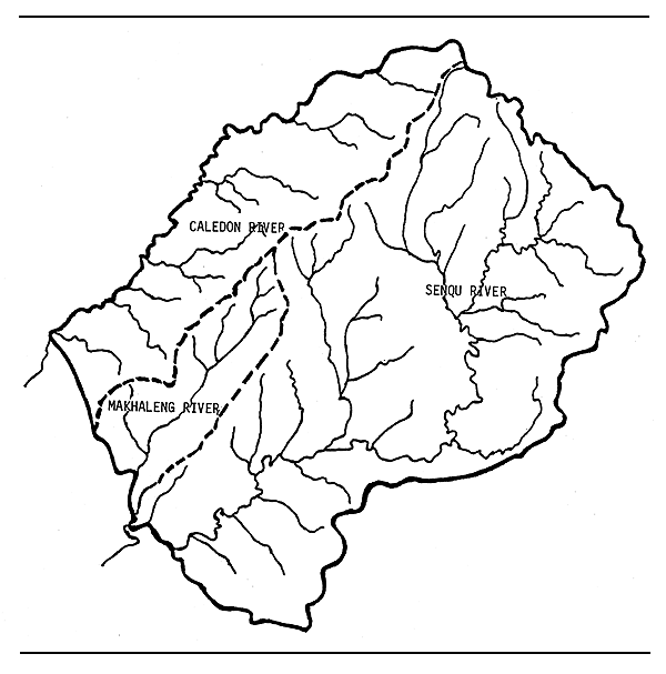
Fig. 1. LESOTHO RIVER SYSTEMS AND THEIR CATCHMENTS
(SWECO, 1975)
Table 1. TOTAL SURFACE WATER RESOURCES OF LESOTHO BY CATCHMENT
| Catchment | Catchment area km2 | Mean annual runoff (MAR) estimates* m3/s | |||
| 1967 | 1969 | 1971 | 1975 | ||
| Senqu at Makhaleng confluence | 20 714 | 91.9 | 101.6 | 91.9 | 99 |
| Makhaleng at Senqu confluence | 3 044 | 17 | 14.2 | 14.2 | 14.2 |
| Caledon at border | 6 694 | - | 24.1 | 24.1 | 27.5 |
| Area between Caledon and Makhaleng | 260 | - | - | - | 0.6 |
| Total | 30 712 | - | 139.9 | 130.2 | 141.2 |
* Sources: see Chondoma, 1988a
The Lesotho Highland Water Project plans to build 4 dams which will develop the highland water resources of the Senqu River for hydroelectricity generation, irrigation, fisheries and water for sale to South Africa. No estimates are available on the surface area of the dams after flooding, but other statistics of the dams to be constructed have been published (LHWP, 1986). The dams will be constructed in three phases, with the first phase expected to start in 1988 and the completion of the final phase planned for 2025.
2.4 Coastal Lagoons
None; Lesotho is landlocked.
3. FISHERY PRODUCTION/POTENTIAL
3.1 Aquaculture
Annual average fish production in Lesotho is about 20 tons. In good production years yields as high as 30 tons have been realized. However, during the recent severe drought experienced in the region, stocked pond area fell from 20 ha to 8.0 ha and fish production fell to 8.8 tons in 1985 (Fisheries Section, Ministry of Agriculture) (see Table 2; updated estimates are given in Table 3).
Table 2. STOCKED POND AREA - Lesotho, 1979–1985
(after Chondoma, 1988a)
| Year | Number of ponds in production | Total pond area (ha) |
| 1979 | 73 | 16.04 |
| 1980 | 67 | 15.77 |
| 1981 | 29 | 5.50 |
| 1982 | 63 | 13.77 |
| 1983 | 102 | 22.55 |
| 1984 | 51 | 11.40 |
| 1985 | 45 | 8.99 |
Fish species currently cultured in Lesotho fall into two main categories:
indigenous: Clarias gariepinus;
introduced: Cyprinus carpio, Hypophthalmichthys molitrix, Salmo gairdneri,
Ctenopharyngodon idella.
Aquaculture production by species from 1982 to 1987 is given below (Vincke, pers.comm., 1989).
| Species | 1982 | 1983 | 1984 | 1985 | 1986 | 1987 |
| Cyprinus carpio | 27 | 17 | 11 | 9 | 20 | 23 |
| Salmo gairdneri | - | - | 1 | 2 | 2 | 1 |
| Clarias gariepinus | 2 | 1 | 1 | - | 3 | 2 |
| Total | 29 | 18 | 13 | 11 | 25 | 26 |
In light of the recent drought the water security situation, and land use trends, an area of 500 ha of intensive commercial fish farms, with current production levels of 1 000–1 500 kg/ha, Chondoma (1988a) estimates potential annual yields of 500–750 tons.
3.2 Fish production and per caput supply
Table 3. FISH PRODUCTION AND PER CAPUT SUPPLY - Lesotho, 1970–1987
| Nominal Domestic Production (excluding exports) (t) 2 | Nominal Consumer Supply (exluding imports and exports (kg/person) | ||||||
| Year | Population '000 1 | Inland capture | Aquaculture 3 | Total | Inland capture | Aquaculture 3 | Total |
| 1970 | 1 064 | - 3 | 0 | 0 2 | - | 0 | 0 |
| 1971 | 1 088 | - | 0 | 0 2 | - | 0 | 0 |
| 1972 | 1 112 | - | 0 | 0 2 | - | 0 | 0 |
| 1973 | 1 137 | - | 0 | 0 2 | - | 0 | 0 |
| 1974 | 1 162 | - | 10 | 10 2 | - | 0.008 | 0.008 |
| 1975 | 1 187 | - | 23 | 23 2 | - | 0.02 | 0.02 |
| 1976 | 1 215 | - | 27 | 27 2 | - | 0.02 | 0.02 |
| 1977 | 1 244 | - | 22 | 22 2 | - | 0.02 | 0.02 |
| 1978 | 1 275 | - | 24 | 24 2 | - | 0.02 | 0.02 |
| 1979 | 1 306 | - | 27 | 27 2 | - | 0.02 | 0.02 |
| 1980 | 1 339 | - | 23 | 23 2 | - | 0.02 | 0.02 |
| 1981 | 1 373 | - | 15 | 15 2 | - | 0.01 | 0.01 |
| 1982 | 1 408 | 2 4 | 29 5 | 31 | 0.001 | 0.02 | 0.02 |
| 1983 | 1 444 | - | 18 5 | 18 | - | 0.01 | 0.01 |
| 1984 | 1 481 | - | 13 5 | 13 | - | 0.01 | 0.01 |
| 1985 | 1 520 | - | 11 5 | 11 | - | 0.01 | 0.01 |
| 1986 | 1 560 | - | 25 5 | 25 | - | 0.02 | 0.02 |
| 1987 | 1 601 | - | 26 5 | 26 | - | 0.02 | 0.02 |
1 Source: FAO
2 Source: FAO Fisheries Department FISHDAB
3 - = data not available
4 SADCC, 1984
5 Vincke, 1989 (pers.comm.)
3.3 Inland catch range and potential yield
Table 4. INLAND CATCH RANGE AND POTENTIAL YIELD
| Water body | Period | Annual catch range (t) | Potential annual yield (t) |
| Senqu River | 1982 | 2 | - |
| Makhaleng River | - | - | - |
| Caledon River | - | - | - |
| Total Rivers | current | 1–2 | 120 |
| Reservoirs | - | - | - |
| Aquaculture | 1974–1987 | 10–30 | 500–750 |
(Sources: see text)
| Total annual yield: | |
| Fishery: | 2 t in 1982 (SADCC, 1984) |
| Aquaculture: | 10–30 t (average: 20 t) |
| Potential annual yield: | |
| Fishery: | 120 t (Maar, 1965) |
| Aquaculture: | 500–750 t (Chondoma, 1988a) |
| Total inland: | 290 t (SADCC, 1984) |
| 620–870 t (Maar, 1965; Chondoma, 1988a) | |
4. STATE OF THE FISHERY (adapted from Chondoma, 1988a)
4.1 Yield
The diversity of fish species in Lesotho is very limited; only 9 indigenous species in 5 genera occur. There are 8 introduced species, 5 of which have acclimatized well in the rivers and reservoirs; 2 are exclusively used in ponds for aquaculture.
There is no capture fishery of any significance in Lesotho. The only existing capture fishery is the sport fishery, mainly for trout and yellowfish in the mountain streams and bass in the lowland reservoirs. There is, however, a seasonal interest in catching yellowfish during the spawning migrations upstream, when they are caught by shepherds using very primitive gear such as stones, sharp sticks and stone traps.
The current estimated catch from the rivers is between 1 and 2 tons, mainly of trout and yellowfish.
The only significant fish production comes from aquaculture (see section 3.1).
4.2 Factors influencing yield
Unpredictable rainfall in dry years may cause the drying up of rivers, reservoirs and ponds. Cool temperatures also slow down growth rates and therefore production. Constraints on aquaculture include low market value of fish and high feed costs.
4.3 Future development possibilities
Information on potential fish production is not available. The only estimate is that done by Maar (1965), which gives riverine annual production from indigenous stocks as 100 tons and 20 tons from trout, if the rivers are regularly restocked with trout fingerlings.
At the 1983 production level of 18 tons and an import of 1 030 tons, an annual increase in production of over 1 000 tons is needed to substitute the imported fish. It is recognized that, at the present rate of aquaculture development and potential (500–750 t) and riverine fishery potential (120 t), Lesotho is unlikely to meet its national fish production requirement in the near future. The greatest potential for fisheries development in Lesotho lies in the realization of the Lesotho Highland Water Project, scheduled to start in 1988 and to be completed in 2025.
5. KEY BIBLIOGRAPHY
Chondoma, 1988a
6. WATER BODIES DIRECTORY
| Rivers |
| Orange (= Senqu) |
| Reservoirs |
| Scott |
| Zacholo |
ORANGE RIVER (= SENQU RIVER)
(International water)
| Geographical data | (Welcomme, 1972) |
| Source: | Lesotho, Drakensberg Mountains |
| Altitude: | 3 300 m |
| Total length: | 2 160 m |
| Drainage area: | 640 000 km2 |
| Countries traversed: | Lesotho, Namibia, South Africa |
| Major tributaries: | Vaal River (1 200 km) |
| Discharges to: | South Atlantic |
| Flood regime: | floods between November and March |
| Physical and chemical data | |
| Conductivity: | K25 159 μ S/cm (mean) (Keulder, 1970) |
| pH: | in upland tributaries of Lesotho, between 6.0 and 7.0 |
SCOTT RESERVOIR
| Geographical data | |
| Location: | Lesotho |
ZACHOLO RESERVOIR
| Geographical data | |
| Location: | Lesotho |
7. BIBLIOGRAPHY
Chondoma, 1988a
Keulder, 1970
LHWP, 1986
Maar, 1965
SADCC, 1984
SWECO, 1975
Welcomme, 1972
![]()
![]()
![]()