![]()
![]()
![]()
1. GEOGRAPHY AND CLIMATE
Mauritius (area of 1 850 km2) is a volcanic island composed mainly of basalt rock. It is situated in the southwest of the Indian Ocean between 57°18' and 57°48' East and between 19°50' and 20°31' South. It is almost entirely surrounded by a barrier coral reef which encloses a lagoon of 243 km2. The inland topography is dominated by three mountain ranges situated in the northwest, southeast and southwest regions and a central plateau which rises to 600 m above sea level.
The climate of Mauritius is determined by its oceanic position and location at 20°S in the belt of the southeast Trade Winds. These winds are stronger in the winter and weaker in summer. About 70% of the rainfall occurs between December and May.
Although Mauritius is predominantly agricultural, there has been rapid industrial growth. Industrial effluents, herbicide and pesticide residues occasionally give rise to pollution problems in localised areas.
2. HYDROGRAPHY
2.1 Lakes
There are two small natural lakes: Grand Bassin and Bassin Blanc. Because of their small area their contribution to fisheries is negligible.
2.2 Rivers, Floodplains and Swamps
Most of the rivers (i.e., Tamarin, Black, Poste, Grand) have their source in the central plateau. The rivers and their tributaries are swift-flowing, of steep gradient interspersed by falls and cascades, although there are also extensive reaches of quiet, slow-moving water in some rivers. The rivers have a total length of 499 km and cover an area of about 331 hectares.
2.3 Reservoirs
There are 10 reservoirs on the island covering an area of about 15 km2. Another fairly large reservoir is under construction for the Champagne Hydroelectric project.
2.4 Coastal Lagoons
There are 25 artificial lagoons (barachois) along the coastline with a combined area of 2.88 km2.
3. FISHERY PRODUCTION/POTENTIAL
3.1 Aquaculture
Total pond area in 1982 was circa 20 ha. Aquaculture production by species is given in Table 1:
Table 1. Aquaculture production (t), by species - Mauritius, 1982–1987
| Species | 1982 | 1983 | 1984 | 1985 | 1986 | 1987 | |
| Marine aquaculture | |||||||
| Osteichthyes (marine) | 11 | 12 | 16 | 16 | 11 | 15 | |
| Scylla serrata | - | - | 1 | 1 | 1 | 4 | |
| Crassostrea cucullata | - | - | 1 | 8 | 8 | 10 | |
| Inland aquaculture | |||||||
| Cyprinidae | 1 | 1 | 1 | 3 | 3 | 5 | |
| Macrobrachium rosenbergii | 22 | 23 | 23 | 25 | 27 | 35 | |
| Total | 34 | 36 | 42 | 53 | 50 | 69 | |
Source: Vincke (1989, pers.comm.)
3.2 Fish production and per caput supply
Table 2. FISH PRODUCTION AND PER CAPUT SUPPLY - Mauritius, 1970–1987
| Nominal Production (including exports) (t) 2 6 | Nominal Consumer Supply (including exports) (kg/person) | ||||||||
| Year | Population '000 1 | Inland capture 5 | Aquaculture 3 | Marine capture 2 | Total | Inland capture 5 | Aquaculture 3 | Marine capture | Total |
| 1970 | 848 | - | - | 3 100 | 3 100 | - | - | 3.6 | 3.6 |
| 1971 | 852 | - | - | 3 500 | 3 500 | - | - | 4.1 | 4.1 |
| 1972 | 856 | - | - | 4 800 | 4 800 | - | - | 5.6 | 5.6 |
| 1973 | 860 | - | 0 2 | 6 400 | 6 400 | - | 0 | 7.4 | 7.4 |
| 1974 | 864 | - | 0 2 | 7 679 | 7 679 | - | 0 | 8.9 | 8.9 |
| 1975 | 868 | - | 0 2 | 7 038 | 7 038 | - | 0 | 8.1 | 8.1 |
| 1976 | 880 | - | 0 2 | 6 660 | 6 660 | - | 0 | 7.5 | 7.5 |
| 1977 | 896 | - | 1 2 | 7 667 | 7 668 | - | 0.001 | 8.5 | 8.5 |
| 1978 | 915 | - | 5 2 | 7 106 | 7 111 | - | 0.005 | 7.8 | 7.8 |
| 1979 | 935 | - | 15 2 | 6 549 | 6 564 | - | 0.01 | 7.0 | 7.0 |
| 1980 | 955 | - | 16 2 | 6 365 | 6 381 | - | 0.01 | 6.7 | 6.7 |
| 1981 | 975 | - | 25 2 | 7 104 | 7 129 | - | 0.02 | 7.3 | 7.3 |
| 1982 | 994 | - | 23 4 | 9 539 | 9 562 | - | 0.02 | 9.6 | 9.6 |
| 1983 | 1 013 | - | 24 4 | 9 894 | 9 918 | - | 0.02 | 9.8 | 9.8 |
| 1984 | 1 050 | - | 24 4 | 10 728 | 10 752 | - | 0.02 | 10.4 | 10.4 |
| 1985 | 1 031 | - | 28 4 | 12 321 | 12 349 | - | 0.03 | 11.8 | 11.8 |
| 1986 | 1 067 | - | 30 4 | 12 855 | 12 885 | - | 0.03 | 12.1 | 12.1 |
| 1987 | 1 085 | - | 40 4 | 17 952 | 17 992 | - | 0.04 | 16.6 | 16.6 |
1 Source: FAO
2 Source: FAO Fisheries Department FISHDAB (Statistics)
3 Inland aquaculture
4 Vincke, 1989 (pers.comm.)
5 data not available
6 from 1980 to 1983, Marine exports were as follows: 1980: 1 650 t; 1981: 1 534 t; 1982: 2 346 t; 1983: 1 680 t
3.3 Inland catch range and potential yield
The only figure available is for inland aquaculture, as shown below. No data are available for Reservoirs Eau Bleue, La Dagotiere, La Ferme, La Nicoliere, Mare aux Vacoas, Mare Longue, Midlands, Piton du Milieu, Tamarin Falls, and Valetta; or for Lagoons Basin Humbert, and Belcourt Bay.
Total annual yield: inland aquaculture: 40 t in 1987.
4. STATE OF THE FISHERY
4.1 Yield
There is considerable angling activity on the reservoirs and rivers, but no catch data is available.
Recorded aquaculture yields are from ponds and artificial lagoons (barachois). Aquaculture production is given under section 3.1.
4.2 Factors influencing yield
Probably heavy drawdowns (>10 m) on many reservoirs and in some cases pollution.
4.3 Future development possibilities
Aquaculture ponds with potential of producing 50 tons of prawns and fin fish exist in the country. There is a good prospect of increasing the number of aquaculture ponds. Production from the reservoirs and rivers can also be enhanced. Stocking of irrigation reservoirs with carps is being undertaken and this will result in increased production from these water bodies. Introduction of extensive culture practices could increase yields by a factor of 2 or more above the “natural” yield level.
5. KEY BIBLIOGRAPHY (none)
6. WATER BODIES DIRECTORY
| Lakes | ||
| Bassin Blanc | Grand Bassin | |
| Reservoirs | ||
| Eau Bleue | Mare aux Vacoas | Piton du Milieu |
| La Dagotiere | Mare Longue | Tamarin Falls |
| La Ferme | Midlands | Valetta |
| La Nicoliere | ||
| Lagoons | ||
| Basin Humbert | ||
| Belcourt Bay | ||
LAKE BASSIN BLANC
| Geographical data | |
| Location: | Mauritius - 20°27'S; 57°27'E |
LAKE GRAND BASSIN
| Geographical data | |
| Location: | Mauritius - 20° 25'S; 57° 29'E |
EAU BLEUE RESERVOIR
| Geographical data | |
| Location: | Mauritius - 20°18'S; 57°36'E |
| Altitude: | 362.71 m asl at USL |
| Surface area: | 0.90 km2 at USL; 0.01 km2 at low level |
| Depth: | 6.78 m (mean at USL) |
| Volume: | 6.1 × 10⁶ m3 at USL |
| Annual fluctuation level: | 18.29 m |
| Major inflowing river: | Eau Bleue |
LA DAGOTIERE RESERVOIR
| Geographical data | |
| Location: | Mauritius - 20°14'S; 57°34'E |
| Surface area: | 0.20 km2 at USL |
LA FERME RESERVOIR
| Geographical data | ||
| Location: | Mauritius - 20°15'S; 57°25'E | |
| Altitude: | 146 m asl at USL | |
| Surface area: | 2.27 km2 at USL; 0.09 km2 at low level | |
| Depth: | 5.20 m (mean at USL) | |
| Volume: | 11.8 × 10⁶ m3 | |
| Annual fluctuation in level: 13.41 m | ||
| Major inflowing rivers: | irrigation feeder channels | |
| Physical and chemical data | ||
| pH: | 8.6 | |
| Ionic composition: | Na | 14 mg/l |
| K | 1.2 mg/l | |
| Total dissolved solids: | 260 mg/l | |
LA NICOLIERE RESERVOIR
| Geographical data | |
| Location: | Mauritius - 20°10'S; 57°36'E |
| Altitude: | 249.02 m asl at USL |
| Surface area: | 0.94 km2 at USL; 0.3 km2 at low level |
| Depth: | 6.15 m (mean at USL) |
| Volume: | 5.78 × 10⁶ m3 at USL |
| Annual fluctuation in level: 11.28 m | |
| Major inflowing river: | Rempoli |
MARE AUX VACOAS RESERVOIR
| Geographical data | ||
| Location: | Mauritius - 20°22'S; 57°30'E | |
| Altitude: | 565.71 m asl at USL | |
| Surface area: | 5.26 km2 at USL; 0.04 km2 at low level | |
| Depth: | 5.25 m (mean at USL) | |
| Volume: | 27.6 × 10⁶ m3 at USL | |
| Annual fluctuation in level: 10.36 m | ||
| Major inflowing rivers: | Grand Ruissero, Poste | |
| Outflowing river: | Tamarin | |
| Physical and chemical data | ||
| pH: | 7.0–7.4 | |
| Ionic composition: | Na | 8 mg/l |
| K | 1.3 mg/l | |
| Total dissolved solids: | 130 mg/l | |
MARE LONGUE RESERVOIR
| Geographical data | |
| Location: | Mauritius - 20°22'S; 57°27'E |
| Altitude: | 576.07 m asl at USL |
| Surface area: | 0.965 km2 at USL; 0.08 km2 at low level |
| Depth: | 6.51 m (mean at USL) |
| Volume: | 6.28 × 10⁶ m3 at USL |
| Annual fluctuation in level: 10.36 m | |
| Major inflowing river: | Aigrettes |
| Physical and chemical data | |
| pH: | 6.9 |
MIDLANDS RESERVOIR
| Geographical data | |
| Location: | Mauritius |
| Surface area: | 2.51 km2 at USL |
| Depth: | 6.22 m (mean at USL) |
| Volume: | 15.6 × 10⁶ m3 at USL |
PITON DU MILIEU RESERVOIR
| Geographical data | ||
| Location: | Mauritius - 20° 17'S; 57° 34'E | |
| Altitude: | 437.39 m asl at USL | |
| Surface area: | 0.688 km2 at USL; 0.05 km2 at low level | |
| Depth: | 4.61 m (mean at USL) | |
| Volume: | 3.17 × 10⁶ m3 at USL | |
| Annual fluctuation in level: 10.67 m | ||
| Major inflowing rivers: | Martin, Vacoas | |
| Physical and chemical data | ||
| pH: | 7.2 | |
| Ionic composition: | Na | 7.2 mg/l |
| K | 0.6 mg/l | |
| Total dissolved solids: | 420 mg/l | |
TAMARIN FALLS RESERVOIR
| Geographical data | |
| Location: | Mauritius - 20° 21'S; 57° 27'E |
| Altitude: | 493.78 m asl at USL |
| Surface area: | 0.715 km2 at USL; 0 km2 at low level |
| Depth: | 3.36 m (mean at USL) |
| Volume: | 2.4 × 10⁶ m3 at USL |
| Annual fluctuation in level: 6.40 m | |
| Major inflowing rivers: | Tamarin, Aigrettes |
| Outflowing river: | Bambous |
VALETTA RESERVOIR
| Geographical data | |
| Location: | Mauritius - 20° 15' S; 57° 34'E |
| Surface area: | 0.60 km2 at USL |
BASIN HUMBERT LAGOON
| Geographical data | |
| Location: | Mauritius |
| Surface area: | 0.52 km2 |
| Special features: | artificial lagoon |
BELCOURT BAY LAGOON
| Geographical data | |
| Location: | Mauritius |
| Surface area: | 0.45 km2 |
| Special features: | artificial lagoon |
1. GEOGRAPHY AND CLIMATE (mainly after Welcomme, 1979a)
The country (with a surface area of 784 090 km2) is divided into three areas:
Finally, there are mountainous areas along the western frontier.
The climate varies from tropical to subtropical, but becomes more temperate in the high plateau and mountainous areas. There is a warm, rainy season from November to March. Rainfall is irregular, particularly in the south.
Mozambique is an entirely agricultural country.
2. HYDROGRAPHY (mainly after Welcomme, 1979a)
(Direcção Provincial dos Serviços Hidråulicos (1969) gives a complete listing of the inland waters of Mozambique.)
2.1 Lakes
Mozambique has 6 400 km2 (21%) of Lake Malawi. Lakes Chilwa and Chiuta lie partly within Mozambique. Both these lakes have highly variable areas, due to the irregularities of rainfall. In addition, there are over 1 000 catalogued small and medium-sized permanent lakes, and an unknown number of seasonal lakes.
2.2 Rivers, Floodplains and Swamps
The main river is the Zambezi, which flows for its last 800 km through Mozambique before entering the Indian Ocean. Other important rivers are the Limpopo (400 km) and the Save (300 km). There are many smaller coastal rivers which, by reason of the irregularities of the rainfall patterns, have hydrological regimes which vary widely from spate to flood.
2.3 Reservoirs
One major reservoir has been installed on the Zambezi River behind the dam at Cahora Bassa. This reservoir has an area of 2 665 km2. There are several other smaller reservoirs of importance.
2.4 Coastal Lagoons
There are over 540 km2 of brackishwater lagoons situated in over 400 water bodies.
3. FISHERY PRODUCTION/POTENTIAL
3.1 Aquaculture
Production from freshwater aquaculture in 1987 reached 21 t, including 4 t of Cyprinus carpio and 17 t of tilapias (Vincke, 1989, pers.comm.). No data are available on the number and area of ponds.
3.2 Fish production and per caput supply
Table 1. FISH PRODUCTION AND PER CAPUT SUPPLY - Mozambique, 1970–1987
| Nominal Domestic Production (excluding exports) (t) 2 | Nominal Consumer Supply (excluding imports and exports) (kg/person) | ||||||||
| Year | Population '000 1 | Inland capture | Aquaculture 3 | Marine capture | Total | Inland capture | Aquaculture 3 | Marine capture | Total |
| 1970 | 8 140 | - 4 | - | 7 600 | 7 600 | - | - | 0.9 | 0.9 |
| 1971 | 8 434 | - | - | 10 400 | 10 400 | - | - | 1.2 | 1.2 |
| 1972 | 8 738 | - | - | 10 400 | 10 400 | - | - | 1.2 | 1.2 |
| 1973 | 9 054 | 0 | - | 13 300 | 13 300 | 0 | - | 1.5 | 1.5 |
| 1974 | 9 380 | 0 | - | 15 660 | 15 660 | 0 | - | 1.7 | 1.7 |
| 1975 | 9 719 | 0 | - | 12 460 | 12 460 | 0 | - | 1.3 | 1.3 |
| 1976 | 10 158 | 0 | - | 14 900 | 14 900 | 0 | - | 1.5 | 1.5 |
| 1977 | 10 617 | 5 000 6 | - | 13 950 | 18 950 | 0.5 | - | 1.3 | 1.8 |
| 1978 | 11 097 | 5 000 | - | 12 940 | 17 940 | 0.4 | - | 1.2 | 1.6 |
| 1979 | 11 599 | 5 000 | - | 25 130 | 30 130 | 0.4 | - | 2.2 | 2.6 |
| 1980 | 12 123 | 5 000 | - | 30 350 | 35 350 | 0.4 | - | 2.5 | 2.9 |
| 1981 | 12 470 | 5 000 | - | 37 130 | 42 130 | 0.4 | - | 3.0 | 3.4 |
| 1982 | 12 827 | 5 000 | - | 34 680 | 39 680 | 0.4 | - | 2.7 | 3.1 |
| 1983 | 13 195 | 5 000 | - | 37 516 | 42 516 | 0.4 | - | 2.8 | 3.2 |
| 1984 | 13 572 | 4 000 | - | 31 847 | 35 847 | 0.3 | - | 2.3 | 2.6 |
| 1985 | 13 961 | 3 000 | - | 33 306 | 36 306 | 0.2 | - | 2.4 | 2.6 |
| 1986 | 14 342 | 762 | 5 5 | 31 154 | 31 921 | 0.05 | 0.0003 | 2.2 | 2.2 |
| 1987 | 14 733 | 246 | 21 5 | 35 850 | 36 117 | 0.02 | 0.001 | 2.4 | 2.4 |
1 Source: FAO
2 Source: FAO Fisheries Department FISHDAB
3 included in “Inland capture” if not specified
4 - = data not available
5 Vincke, 1989 (pers.comm.)
6 working estimate from 1977 to 1985
3.3 Inland catch range and potential yield
Table 2.
| Water body | Period | Annual catch range (t) 1 | Potential annual yield (t) 1 |
| Lake Malawi/Nyasa | - | - | 19 200–25 600 |
| Cahora Bassa Reservoir | 1982 | 4 300 | 8 000 |
| Massingir Reservoir | 1981 | 400 | - |
No data available for:
Lakes Amaramba, Banamana, Chilwa, Chiuta, Marangua, Neguri, Nhangela,
Nhangulaze and Nhavarre;
Rivers Buzi, Incomati/Komati, Limpopo, Luangwa, Lurio, Maputo/Pongolo,
Pungoe, Ruvuma, Save/Sabi, Shire/Chire and Zambezi;
Reservoirs Chicamba Real and Pequenos Libombos;
Lagoons Babatilene, Bilene Complex, Bumbe, Buti, Chaguefula, Changue,
Chombonhane, Funguene, Inhassoro, Machane, Macumbe, Macumline,
Madacanine, Mahanse, Mambeze, Mandjene, Mangalidje, Massanguane,
Matibe, Munde, Nela, Nhamanene, Piti, Quissico Complex, Satine, Sugi,
Tzembezanhe, Xamane, Xavi, Xingute and Zuali.
| Total annual yield: | 5 000 t in 1982 (rough estimate, see Table 1) |
| 246 t in 1987 | |
| Potential annual yield: | 55 000 t (SADCC, 1984) |
4. STATE OF THE FISHERIES
4.1 Yield
While no firm estimates exist for production, a figure of about 5 000 t has been advanced as a working estimate. The potential catch of the country is no doubt considerable (c. 55 000 t; c. 30 000 t for Lake Malawi/Nyasa and Cahora Bassa Reservoir). There are extensive resources in lagoons, lakes and rivers, and active fisheries have existed in the past.
4.2 Factors influencing yield
Catches from inland fisheries are very low, mainly because of the drastic shortage of fishing gear and an unstable security situation. Furthermore, communications within the country are very poor and marketing networks are generally absent.
4.3 Future development possibilities
Until there is an amelioration in the internal security situation and also a nationwide increased availability of inexpensive fishing materials, a significant increase in inland fish production cannot be foreseen. Mozambique, in the long term, possesses excellent potential for inland fishery development.
5. KEY BIBLIOGRAPHY
Mikkola, 1982
6. WATER BODIES DIRECTORY
| Lakes | ||||
| Amaramba | Malawi/Nyasa | Nhangela | ||
| Banamana | Marangua | Nhangulaze | ||
| Chilwa | Neguri | Nhavarre | ||
| Chiuta | ||||
| Rivers | ||||
| Buzi | Lurio | Save/Sabi | ||
| Incomati/Komati | Maputo/Pongolo | Shire/Chire (& floodplain) | ||
| Limpopo | Pungoe | Zambesi | ||
| Luangwa | Ruvuma | |||
| Reservoirs | ||||
| Cahora Bassa | Massingir | |||
| Chicamba Real | Pequenos Libombos | |||
| Lagoons | ||||
| Babatilene | Funguene | Mahanse | Munde (Maundo) | Sugi |
| Bilene Complex | Inhassoro | Mambeze | Nela | Tzembezanhe |
| Bumbe | Machane | Mandjene (Pandjene) | Nhamanene Complex | Xamane |
| Buti | Macumbe | Mangalidje | Piti | Xavi (Chavi) |
| Chaguefula | Macumline | Massanguane | Quissico Complex | Xingute (Chinguti) |
| Changue | Madacanine | Matibe | Satine (Sotiba) | Zuali |
| Chombonhane | ||||
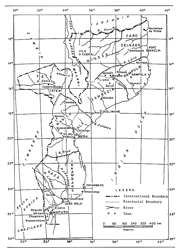
Fig. 1. MAP OF MOZAMBIQUE
(FAO/UNDP, 1981a)
LAKE AMARAMBA
| Geographical data | |
| Location: | Mozambique - 14° 21–38'S; 35° 55'E |
| Altitude: | 655 m |
| Surface area: | 60 km2 |
| Depth: | 5 m (max) |
| Max. length: | 33 km |
| Max. width: | 2 km |
| Major inflowing rivers: | Lugenda (outflow from Lake Chiuta) |
| Outflowing river: | Lugenda |
LAKE BANAMANA
| Geographical data | |
| Location: | Mozambique - 22° 10'S; 33° 55'E |
| Surface area: | 20 km2 |
| Max. length: | 9.5 km |
| Max. width: | 3 km |
| Outflowing river: | none; internal basin |
LAKE CHILWA
(International water)
| Geographical data | |
| Location: | Malawi, Mozambique - 15° 15'S; 35° 45'E |
| Altitude: | 654 m |
| Surface area: | very variable: 259–2 590 km2; mean: 750 km2 with a surrounding swampy area of 1 000 km2. Only a minute portion of the lake is situated in Mozambique (29 km2 max) |
| Depth: | 5 m (max); 2.0 m (mean) |
| Max. length: | 45 km |
| Max. width: | 32 km |
| Annual fluctuation in level: 1.3 m (lake may dry up completely on occasions) | |
| Major inflowing rivers: Thondwe, Likangala, Sombani | |
| Outflowing river: | none; internal basin |
| Physical and chemical data | |
| Surface temperature: | 21–37° C (Kalk, 1969) |
Surface water characteristics in the open water of Lake Chilwa in a ‘normal’ year (1970) (Source: Mepham, 1987a)
| February | July | December | ||
| Depth: | (m) | 2.05 | 1.55 | 1.0 |
| Conductivity: | (μS/cm) | 800 | 1 500 | 2 500 |
| pH: | 8.2 | 8.6 | 8.8 | |
| Total alkalinity: | (meq/l) | 7.15 | 8.7 | 19.0 |
| Oxygen: | (mg/l) | 5.6 | 10.0 | 6.7 |
| Transparency: | (Secchi) (cm) | 7.5 | 8.5 | 11.0 |
| Ionic composition: | mg/l | mg/l | mg/l | |
| Na+ | 189 | 350 | 780 | |
| K+ | 14.0 | 10.5 | 23.1 | |
| Ca2+ | 10.8 | 13.4 | 13.2 | |
| Mg2+ | 6.4 | 6.3 | 8.6 | |
| Cl- | 182 | 277 | 515 | |
| μg/l | μg/l | μg/l | ||
| PO4-P | 1 240 | 1 214 | 2 000 | |
| NO3-N | n.d. | n.d. | 59 |
| Fisheries data | |
| No. of fish species: | 28 (cited in Balarin, 1987) |
| Main catches: | Oreochromis shiranus; Barbus paludinosus; Clarias gariepinus (Mepham, 1987a) |
| Total annual catch and effort: varies with water level and area | |
| Potential annual yield: 20 000 t (for max area) in Malawi (Chaika, 1982); no data for Mozambique waters. | |
| Specific reference: | detailed data and bibliography in Mepham, 1987a. |
LAKE CHIUTA
(International water)
| Geographical data | |
| Location: | Malawi, Mozambique - 14° 45'S; 35° 50'E |
| Altitude: | 620 m |
| Surface area: | total: 200 km2 (40 km2 in Mozambique) |
| Depth: | 5 m |
| Max. length: | 21 km |
| Max. width: | 8 km |
| Catchment area: | 2 000 km2 |
| Outflowing river: | Lugenda |
| Special features: | a sandbar only 25 m higher than the floodplain separates Lake Chiuta from Lake Chilwa (Mepham, 1987a). |
| Physical and chemical data (Welcomme, 1972) | |
| Surface temperature: | 21–37° C |
| Conductivity: | K20 150 μ S/cm |
| pH: | 7.0–8.0 |
| Dissolved solids: | 0.10–0.15 g/l |
| Fisheries data | |
| No. of fish species: | 40 (cited in Balarin, 1987) |
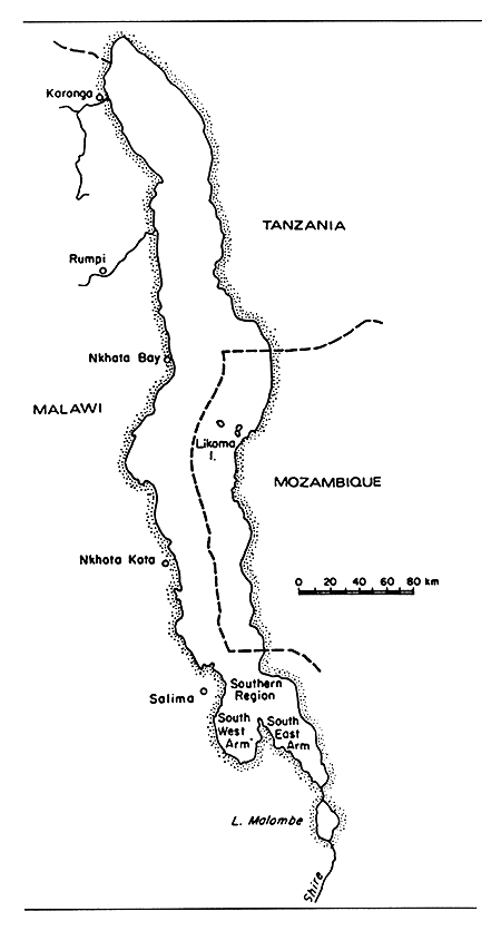
Fig. 2. LAKES MALAWI AND MALOMBE
(Welcomme, 1972)
LAKE MALAWI/NYASA
(International water)
| Geographical data | (Welcomme, 1972) |
| Location: | Malawi, Mozambique, Tanzania |
| Altitude: | 471 m |
| Surface area: | 30 800 km2 (24 400 km2 in Malawi; 6 400 km2 in Mozambique) Tanzania claims 5 569 km2 of Malawian waters (see Fig. 2) |
| Depth: | 758 (max); 426 (mean) |
| Volume: | 8 400 km3 |
| Max. length: | 603 km |
| Max. width: | 87 km |
| Shoreline: | 1 500 km (total lake); 300 km in Tanzania |
| Catchment area: | 65 000 km2 |
| Annual fluctuation in level: 6 m | |
| Major inflowing rivers: | Ruhuhu, Songwe |
| Outflowing river: | Shire |
| Special features: | Although Tanzania has some 300 km of shoreline on the lake, the Nyasa area is remote from major centres of population, development activity has been minimal over the years, and evolution of the fisheries has not been well documented. It is not known to what extent development of the Nyasa fisheries is complicated by the question of territorial jurisdiction. Around the time of independence, it was reported that the formal border between Malawi and Tanzania coincided with the Tanzanian shoreline so that, in theory, all the waters of the lake belonged to Malawi (Dibbs, 1964). |
| Physical and chemical data (Jackson et al., 1963) | ||||
| Surface temperature: | 23–25° C | |||
| Conductivity: | K20 220 μ S/cm | |||
| pH: | 7.7–8.6 | |||
| Alkalinity: | N × 10-4: 20.0–25.9 | |||
| Ionic composition: | (Jackson et al., 1963) | (Talling & Talling, 1965) | ||
| mg/l | mg/l | |||
| Na | - | 21.0 | ||
| K | - | 6.4 | ||
| Ca | 15.1–20.2 | 19.8 | ||
| CaCO3 | 100.0–129.0 | - | ||
| HCO3 + CO3 | - | 144.0 | ||
| Mg | 6–9 | 4.7 | ||
| Cl | - | 4.3 | ||
| SO4 | - | <5.0–5.5 | ||
| SiO2 | 1.5–7.0 | 1.1 | ||
| NO3-N | 0.02 | - | ||
| PO4-P | 0.1–0.2 | - | ||
| Fisheries data | |
| No. of fish species: | 245 described species, of which 193 are cichlids (Greenwood, 1964) |
| Main catches: | inshore waters: Haplochromis spp. open waters: Engraulicypris sardella (Marshall, 1984a) |
| No. of fishermen: | no data available |
| No. of boats: | no data available |
| Total annual catch and effort: no data available | |
| Potential annual yield: | 19 200–25 600 t in Mozambique (30–40 kg/ha/yr: FAO 1982a) |
| Specific reference: | FAO, 1982a |
LAKE MARANGUA
| Geographical data | |
| Location: | Mozambique - 24° 44'S; 34° 14'E |
| Surface area: | 63 km2 |
| Max. length: | 18 km |
| Max. width: | 5 km |
| Outflowing river: | none; internal basin |
LAKE NEGURI
| Geographical data | |
| Location: | Mozambique - 11° 46'S; 40° 05'E |
| Surface area: | 8.4 km2 |
| Max. length: | 4 km |
| Max. width: | 3 km |
LAKE NHANGELA
| Geographical data | |
| Location: | Mozambique - 24° 21'S; 35° 00'E |
| Surface area: | 15.8 km2 |
| Max. length: | 9 km |
| Max. width: | 2.5 km |
| Outflowing river: | none; internal basin |
LAKE NHANGULAZE
| Geographical data | |
| Location: | Mozambique - 24° 00'S; 34° 26'E |
| Surface area: | 14.7 km2 |
| Max. length: | 10.5 km |
| Max. width: | 2 km |
| Outflowing river: | Inhamiquilengue |
LAKE NHAVARRE
| Geographical data | |
| Location: | Mozambique - 23° 47'S; 34° 48'E |
| Surface area: | 22.1 km2 |
| Max. length: | 7 km |
| Max. width: | 4.5 km |
| Outflowing river: | none; internal basin |
BUZI RIVER
(International water)
| Geographical data | |
| Source: | near Chipinga, Zimbabwe |
| Altitude: | 1 326 m |
| Total length: | 360 km total (35 km in Zimbabwe) |
| Drainage area: | 28 800 km2 total (25 600 km2 in Mozambique; 3 200 km2 in Zimbabwe) |
| Countries traversed: | Mozambique, Zimbabwe |
| Major tributaries: | Revue, Lucite |
| Discharges to: | Indian Ocean - 19° 52' S; 34° 46'E |
| Volume of discharge at mouth: 1.45 km3/yr | |
| Special features: | Chicamba Real reservoir on Revue tributary; floodplain along lower course. |
INCOMATI/KOMATI RIVER
(International water)
| Geographical data | |
| Source: | near Breyten, South Africa |
| Altitude: | 1 832 m |
| Total length: | 714 km total (265 km in Mozambique; |
| 95 km in Botswana; 354 km in South Africa) | |
| Drainage area: | 46 246 km2 total (14 925 km2 in Mozambique; |
| 2 500 km2 in Swaziland; 28 821 km2 in South Africa) | |
| Countries traversed: | Mozambique, Swaziland, South Africa |
| Major tributaries: | Sabia, Crocodile |
| Discharges to: | Indian Ocean - 25° 49'S; 32° 44'E |
| Volume of discharge at mouth: 2.3 km3/yr | |
| Flood regime: | unimodal flood peaking in January-February |
| Special features: | several reservoirs including Hartbeespoort and Sand River; floodplain in the lower course, including Lake Chuali (28 km2) and several smaller lakes. |
LIMPOPO RIVER
(International water)
| Geographical data | |
| Source: | Witwatersrand, South Africa |
| Altitude: | 1 732 m |
| Total length: | 1 680 km |
| Drainage area: | 358 000 km2 total (79 600 km2 in Mozambique) |
| Countries traversed: | Botswana, Zimbabwe, Mozambique, South Africa |
| Major tributaries: | Elefantes/Olifants, Nuanetsi, Umzingwani, Shashi, Changane |
| Discharges to: | Indian Ocean - 25° 12'S; 33° 31'E |
| Volume of discharge at mouth: 5.33 km3/yr | |
| Special features: | numerous dams/reservoirs on tributaries, including Massingir (151 km2) floodplain along lower course with numerous lakes, including Lakes Gondeza, Pave (2 km2), Chinanga (5 km2), Bambene and Linguazi (4 km2 combined), and Nhangul. |
LUANGWA RIVER
(International water)
| Geographical data | |
| Source: | near Zambia/Malawi frontier |
| Altitude: | 1 658 m asl |
| Total length: | 790 km total (710 km in Zambia; 80 km along Zambian/Mozambique frontier) |
| Drainage area: | 147 500 km2 |
| Countries traversed: | Zambia, Mozambique |
| Major tributaries: | Lukusashi, Lusemfwa |
| Discharges to: | Cahora Bassa Reservoir confluently with the Zambezi River |
| Volume of discharge at mouth: 8 km3/yr | |
| Flood regime: | main discharge from April to July |
| Special features: | two reservoirs (Mulungushi and Mita Hills) within the Lusemfwa tributary basin. |
LURIO RIVER
| Geographical data | |
| Source: | near Molumbo, Mozambique |
| Altitude: | 1 321 m |
| Total length: | 595 km |
| Drainage area: | 60 800 km2 |
| Countries traversed: | Mozambique |
| Discharges to: | Indian Ocean - 13° 31'S; 40° 32'E |
| Volume of discharge at mouth: 7.33 km3/yr | |
MAPUTO/PONGOLO RIVER
(International water)
| Geographical data | |
| Source: | Drakensberg Mountains, South Africa |
| Altitude: | 2 277 m |
| Total length: | 565 km total (90 km in Mozambique; 475 km in South Africa) |
| Drainage area: | 29 800 km2 total (1 570 km2 in Mozambique; |
| 10 320 km2 in Swaziland; 17 910 km2 in South Africa) | |
| Countries traversed: | Mozambique, Swaziland (Lusutfu trib. basin), S. Africa |
| Major tributaries: | Lusutfu |
| Discharges to: | Indian Ocean (Maputo Bay) - 26° 11'S; 32° 41'E |
| Volume of discharge at mouth: 2.8 km3/yr | |
| Special features: | Pongolapoort Reservoir (133 km2); Pongolo floodplain (130 km2) with about 90 small lakes between Pongolapoort dam and the confluence with the Lusutfu River. Floodplain along Mozambique stretch with associated lakes (i.e. Lake Mandjane (10 km2), Lakes Natali and Changare). |
PUNGOE RIVER
(International water)
| Geographical data | |
| Source: | near Watsomba, Zimbabwe |
| Altitude: | 2 033 m |
| Total length: | 300 km (40 km in Zimbabwe) |
| Drainage area: | 29 500 km2 total (28 000 km2 in Mozambique; 1 500 km2 in Zimbabwe) |
| Countries traversed: | Mozambique, Zimbabwe |
| Major tributaries: | Urema, Vunduzi, Nhazonia |
| Discharge to: | Indian Ocean - 19° 51'S; 34° 48'E |
| Volume of discharge at mouth: 3.08 km3/yr | |
| Special features: | floodplains on lower course and on Urema tributary |
RUVUMA RIVER
(International water)
| Geographical data | |
| Source: | near Songea, Tanzania |
| Altitude: | 1 558 m |
| Total length: | 640 km |
| Drainage area: | 165 760 km2 (113 701 km2 in Mozambique; 52 059 km2 in Tanzania) |
| Countries traversed: | Mozambique, Tanzania |
| Major tributaries: | Lugenda in Mozambique (555 km-long-channel) |
| Discharges to: | Indian Ocean - 10° 28'S; 40° 25'E |
| Special features: | Lakes Chiuta and Amaramba on Lugenda tributary; floodplain and several associated lakes on lower course (i.e., Lake Chidya in Tanzania and Lake Nangade in Mozambique). |
SAVE/SABI RIVER
(International water)
| Geographical data | |
| Source: | Zimbabwe (south of Harare) |
| Altitude: | 1 693 m |
| Total length: | 715 km total (400 km in Zimbabwe; 315 km in Mozambique) |
| Drainage area: | 88 395 km2 (83 845 km2 in Zimbabwe; 4 550 km2 in Mozambique) |
| Countries traversed: | Mozambique, Zimbabwe |
| Major tributaries: | Lundi |
| Discharges to: | Indian Ocean - 20° 58'S; 35° 05'E |
| Volume of discharge at mouth: 5 km3/yr | |
| Special features: | Several reservoirs within Lundi tributary basin including Kyle, Bangala, Manjirenje and Tokwe Mokorsi |
SHIRE/CHIRE RIVER AND FLOODPLAIN
(International water)
| Geographical data | |
| Source: | Lake Malawi/Nyasa (see Fig. 2) |
| Altitude: | 470 m |
| Total length: | 520 km (375 km in Malawi; 75 km along Malawi-Mozambique frontier; |
| 70 km in Mozambique) | |
| Countries traversed: | Mozambique, Malawi |
| Discharges to: | Zambezi River - 17° 42'S; 35° 19'E |
| Volume of discharge at mouth: 283–566 m3/sec | |
| Flood regime: | floods between January and April |
| Special features: | in Malawi: Lake Malombe in upper course and Elephant Marsh floodplain/swamp in lower course (500 km2 flooded permanently and up to circa 1 000 km2 flooded during rainy season) |
| Physical and chemical data (Welcomme, 1972) | |||
| Upper course | Middle course | Lower Course | |
| Temperature: °C | 10–25 | 20–30 | 20–35 |
| pH: | 7.5–8.2 | - | - |
| Conductivity: K20 | 220 μ S/cm | - | 225 μ S/cm |
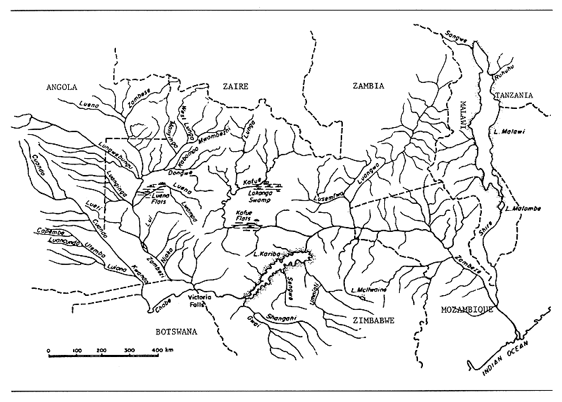
Fig. 3. RIVERS AND LAKES OF THE ZAMBEZI
(Welcomme, 1972)
ZAMBEZI RIVER
(International water)
| Geographical data (Welcomme, 1972) | |
| Source: | northwest Zambia and eastern Angola (see Fig. 3) |
| Altitude: | 1 600 m |
| Total length: | 2 574 km |
| Drainage area: | 1 300 000 km2 |
| Countries traversed: | Angola, Mozambique, Zambia, Botswana, Namibia, Zimbabwe |
| Major tributaries: | Cuando, Kafue, Luangwa, Shire. The Zambezi system also communicates with the Okovango system via the Chobe River. |
| Discharges to: | Indian Ocean - 18°47'S; 36°E |
| Volume of discharge at mouth: 7 070 m3/sec | |
| Flood regime: | December to July, maximum in March |
| Special features: | Barotse floodplain (700–9 000 km2), Kafue flats (200–7 000 km2), Lukanga swamps (3 000–8 000 km2), Kariba and Cahora Bassa dams/reservoirs. |
Physical and chemical data above Lake Kariba (Coche, 1968)
| Flood | Low water | |||
| Temperature: | 30°C | 17°C | ||
| pH: | - | 7.4 | ||
| Conductivity: | K20: 50 μ S/cm | 96 μ S/cm | ||
| Total alkalinity: | 20 mg/l | 44 mg/l | ||
| Total hardness: | 17.9 mg/l | 38.1 mg/l | ||
| Ionic composition: | mg/l | mg/l | ||
| Na | 1.70 | 3.26 | ||
| K | - | 0.88 | ||
| Ca | 4.93 | - | ||
| Mg | 1.47 | 3.86 | ||
| NO2-N | 0.00376 | 0.00024 | ||
| NO3-N | 0.0047 | 0.0158 | ||
| PO4-P | 0.0295 | 0.0078 |
Fisheries data
No. of fish species: Upper Zambezi: 49; Middle Zambezi: 50 (Jubb, 1961)
CAHORA BASSA RESERVOIR
| Geographical data | |
| Location: | Mozambique - 15°29' –16°00'S; 30°25' –32°44'E (see Fig. 4) |
| Altitude: | 326 m asl at upper regulated level |
| Date closed: | 1975 |
| Surface area: | 2 665 km2 |
| Depth: | 156 m (max); 20.92 m (mean) |
| Volume: | 55.75 km3 |
| Max. length: | 246 km |
| Max. width: | 39.8 km |
| Shoreline: | 1 775 km |
| Annual fluctuation in level: 6.98–14.06 m | |
| Major inflowing river: | Zambezi |
| Outflowing river: | Zambezi |
| Physical and chemical data | |||
| Surface temperature: | 20.8–23.7°C | ||
| Conductivity: | K20 112–132 μ S/cm | ||
| Dissolved solids: | 81–114 mg/l | ||
| Ionic composition: | |||
| mg/l | |||
| Na | 2.97–11.13 | ||
| Ca | 6.81–25.65 | ||
| Mg | 1.94–5.72 | ||
| HCO3 | 39.66–97.63 | ||
| SO4 | 2.30–16.62 | ||
| Fe | 0.10–0.14 | ||
| Mn | 0–20 | ||
| NO3-N | trace-1.1 | ||
| NH3-N | 0–0.17 | ||
| PO4 | trace | ||
| Fisheries data | |||
| No. of fish species: | |||
| 33 + the pelagic sardine Limnothrissa miodon, which was introduced into Kariba reservoir earlier, and has successfully established itself in Cahora Bassa. No fishery has as yet developed for it; the nominal catch at present consists largely of Hydrocynus, Distichodus, Clarias and other table fish species. | |||
| Total annual catch: 4 343 t (estimate for 1982) | |||
| Potential annual yield: 8 000 t | |||
| (30 kg/ha/yr - Bernacsek & Lopes, 1984; Marshall, 1984a) Productivity may be this low because of the heavy clay load in the water which reduces light penetration and may inhibit primary production (Gliwicz, 1984). | |||
| Specific reference: Gliwicz, 1984; Bernacsek & Lopes, 1984; Vostradovsky, 1984 | |||
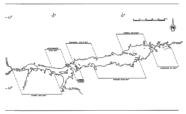
Fig. 4. CAHORA BASSA RESERVOIR
(Gliwicz, 1984)
CHICAMBA REAL RESERVOIR
| Geographical data | |
| Location: | Mozambique - 19° 09'S; 33° 07'E |
| Surface area: | 120 km2 |
| Max. length: | 29 km |
| Max. width: | 5.5 km |
| Major inflowing river: | Revue |
| Outflowing river: | Revue |
MASSINGIR RESERVOIR
| Geographical data | |
| Location: | Mozambique - 23° 53'S; 32° 09'E |
| Altitude: | 109 m USL |
| Dam height: | 30 m |
| Date closed: | 1978 |
| Surface area: | 150.78 km2 at USL |
| Depth: | 70 m (max); 18.7 m (mean) |
| Volume: | 2.8 km3 |
| Annual fluctuation in level: 6–7 m | |
| Major inflowing rivers: | Elephantes |
| Outflowing river: | Elephantes |
| Physical and chemical data | |
| Surface temperature: | 25.2–25.9° C |
| Conductivity: | 230–245 μ S/cm |
| pH: | 8.5 |
| Fisheries data | |
| No. of fishermen: | 70 (1981) |
| No. of boats: | 18 (1981) |
| Total annual catch: | circa 400 t (1981) |
PEQUENOS LIBOMBOS RESERVOIR
| Geographical data | |
| Location: | Mozambique - 26°02'S; 32°26'E |
| Surface area: | 47 km2 at USL (16 km2 min) |
| Depth: | 10 m mean at USL (6 m mean at drawdown) |
| Major inflowing rivers: | Umbeluzi, Calichane |
| Outflowing river: | Umbeluzi |
BABATILENE LAGOON
| Geographical data | |
| Location: | Mozambique |
| Surface area: | 0.5 km2 |
BILENE LAGOON COMPLEX
| Geographical data | |
| Location: | Mozambique - 25° 11'–27'S; 32° 58'–33° 26'E |
| Surface area: | 55 km2 combined |
| Special features: | a complex of lagoons situated south of the Limpopo River consisting of five main lagoons: Uembje (21.7 km2); Nhacheundezo (4.9 km2); Muandeje (14.7 km2); Pati (12.6 km2) and Sane, plus several smaller lagoons. |
BUMBE LAGOON
| Geographical data | |
| Location: | Mozambique |
| Surface area: | 0.55 km2 |
BUTI LAGOON
| Geographical data | |
| Location: | Mozambique |
| Surface area: | 1 km2 |
CHAGUEFULA LAGOON
| Geographical data | |
| Location: | Mozambique |
| Surface area: | 0.5 km2 |
CHANGUE LAGOON
| Geographical data | |
| Location: | Mozambique |
| Surface area: | 0.8 km2 |
CHOMBONHANE LAGOON
| Geographical data | |
| Location: | Mozambique |
| Surface area: | 1.5 km2 |
FUNGUENE LAGOON
| Geographical data | |
| Location: | Mozambique |
| Surface area: | 3.5 km2 |
INHASSORO LAGOON
| Geographical data | |
| Location: | Mozambique - 21° 37'S; 35° 14'E |
| Surface area: | 15 km2 |
| Max. length: | 11 km |
| Max. width: | 3 km |
MACHANE LAGOON
| Geographical data | |
| Location: | Mozambique |
| Surface area: | 3 km2 |
MACUMBE LAGOON
| Geographical data | |
| Location: | Mozambique |
| Surface area: | 1.5 km2 |
MACUMLINE LAGOON
| Geographical data | |
| Location: | Mozambique |
| Surface area: | 0.6 km2 |
MADACANINE LAGOON
| Geographical data | |
| Location: | Mozambique |
| Surface area: | 1 km2 |
MAHANSE LAGOON
| Geographical data | |
| Location: | Mozambique |
| Surface area: | 1.30 km2 |
MAMBEZE LAGOON
| Geographical data | |
| Location: | Mozambique |
| Surface area: | 2 km2 |
MANDJENE (= PANDJENE) LAGOON
| Geographical data | |
| Location: | Mozambique |
| Surface area: | 10 km2 |
MANGALIDJE LAGOON
| Geographical data | |
| Location: | Mozambique |
| Surface area: | 1.2 km2 |
MASSANGUANE LAGOON
| Geographical data | |
| Location: | Mozambique |
| Surface area: | 0.5 km2 |
MATIBE LAGOON
| Geographical data | |
| Location: | Mozambique |
| Surface area: | 1.15 km2 |
MUNDE (= MAUNDO) LAGOON
| Geographical data | |
| Location: | Mozambique |
| Surface area: | 7 km2 |
NELA LAGOON
| Geographical data | |
| Location: | Mozambique |
| Surface area: | 0.85 km2 |
NHAMANENE LAGOON COMPLEX
| Geographical data | |
| Location: | Mozambique - 22° 15'–38'S; 35° 25'–32'E |
| Surface area: | combined area circa 50 km2 |
| Special features: | a cluster of over 40 coastal lagoons varying from freshwater to brackishwater. Includes Nhamanene (12.6 km2), Manhali (11.6 km2), Zevane (7.0 km2), Muanga (4.6 km2), Nhalenhengue and Colotiva Lagoons. |
PITI LAGOON
| Geographical data | |
| Location: | Mozambique - 26° 34'S; 32° 53'E |
| Surface area: | 32.5 km2 |
| Max. length: | 12 km |
| Max. width: | 4.5 km |
QUISSICO LAGOON COMPLEX
| Geographical data | |
| Location: | Mozambique - 24° 15'–25° 01'S; 33° 55'–35° 25'E |
| Surface area: | combined area of 300 km2 |
| Depth: | generally max of 5 m, but up to 20 m in Poelala |
| Major inflowing river: | Inharrime |
| Outflow: | to Indian Ocean |
| Salinity: (‰) | Massava Lagoon: 3–4; Quissico Lagoon: 4.3; Inhagotou Lagoon: 4.6; Canda Lagoon: 7.0 |
| Special features: | a complex of lagoons situated between the Inharrime and Limpopo Rivers, consisting of several minor and 20 larger lagoons: Nhacucu, Poelala (90 km2), Inhassengane, Mahune, Massava, Muhanze, Quissico, Nhambavale, Canda, Zangabade, Malembue, Nhanzingue, Magombene, Nhanvue, Nhambavale, Tomezoe, Nhanzume, Vanze, Muie and Valute. Tomezoe Lagoon is heavily infested with aquatic vegetation. |
SATINE (= SOTIBA) LAGOON
| Geographical data | |
| Location: | Mozambique - 26°45'S; 32°51'E |
| Surface area: | 7.5 km2 |
SUGI LAGOON
| Geographical data | |
| Location: | Mozambique |
| Surface area: | 0.5 km2 |
TZEMBEZANHE LAGOON
| Geographical data | |
| Location: | Mozambique |
| Surface area: | 3.5 km2 |
XAMANE LAGOON
| Geographical data | |
| Location: | Mozambique |
| Surface area: | 0.7 km2 |
XAVI (= CHAVI) LAGOON
| Geographical data | |
| Location: | Mozambique |
| Surface area: | 0.8 km2 |
XINGUTE (= CHINGUTI) LAGOON
| Geographical data | |
| Location: | Mozambique |
| Surface area: | 17.5 km2 |
ZUALI LAGOON
| Geographical data | |
| Location: | Mozambique |
| Surface area: | 2 km2 |
7. BIBLIOGRAPHY
Balarin, 1987
Bernacsek & Lopes, 1984
Chaika, 1982
Coche, 1968
Dibbs, 1964
Direcção Provincial dos Serviços Hidràulicos, 1969
FAO, 1982a
FAO/UNDP, 1981a
Gliwicz, 1984
Greenwood, 1964
Jackson et al., 1963
Jubb, 1961
Kalk, 1969
Marshall, 1984a
Mepham, 1987a
Mikkola, 1982
SADCC, 1984
Talling & Talling, 1965
Vostradovsky, 1984
Welcomme, 1972; 1979a
![]()
![]()
![]()