![]()
![]()
![]()
The conservation/environmental management approaches suggested below are keyed to facilitating economic development while preventing unnecessary loss of resources.
In most countries, a pollution control authority has been established and is operating. Such an authority will retain continuing responsibility for pollution, and ICZM should coordinate with that authority regarding conformance of development projects with national pollution standards. In this role, projects with unacceptable potentials for pollution would be discouraged or modified to acceptability and conformance with standards.
ICZM programmes should focus on special coastal pollution sources not presently addressed, perhaps those caused by watershed disturbance and runoff and, especially, those that affect critical habitats. Of particular concern is sediment runoff from construction sites, farmlands, forest-cutting and land-clearing operations. Also, pollutants flushed by storm runoff into coastal waters can create toxicity (biocides, oil wastes, etc.) and bring excessive nutrients (fertilizer, animal wastes).
It should not be surprising that pollution is at its worst in the harbours of large coastal cities and industrial ports. Whether the pollution is from oxygen-depleting organic waste (e.g., sewage) or from toxic industrial wastes, it is damaging to coastal environments and resources as well as a risk to human health. Therefore, harbour projects should be intensively studied in the project review element and a maximum of conservation safeguards employed.
Control of land-based pollution is very complex. It requires major changes in agricultural and industrial practices, as well as the development of waste treatment technology, according to the IUCN draft world conservation strategy (IUCN,1990). The main changes needed are stated to include: comprehensive control of sewage discharges; reducing runoff of fertilizers and livestock wastes from agricultural land through the adoption of high standards of land husbandry; and limiting industrial effluents through more efficient use of resources. Special attention should be paid to controlling industrial wastes and improving sewage treatment to reduce risks to public health from consuming seafood and bathing in contaminated water (IUCN, 1990).
Another pollution source of particular relevance to ICZM is oil pollution that originates during exploration, production and transportation phases of the oil industry. Chua and Charles (1984) emphasize that: “In recent years, oil pollution of the marine environment has been an issue of considerable national and international concern”. The deleterious effects on the marine environment and the living resources as a result of growing frequency of oil spills have caused public awareness and widespread political attention. It is interesting to note that of the total budget of petroleum hydrocarbons introduced into the oceans, 34.9% arise from marine transportation, 26.2% from river runoff, 9.8% each from natural seeps and atmosphere rain, 4.9% each from urban runoff, industrial and municipal waste, while oil refineries and production account for only 3.3% and 1.3% respectively. The total contribution from offshore oil production in terms of blowout of oil-wells or leakage from producing sites is reported to be relatively insignificant (Chua and Charles, 1984).
Coastal waters are particularly susceptible to pollution where they receive the outflow of streams and rivers in lagoons or estuaries. It should be noted from the above that 66% of oil entering the sea is from marine transportation or local runoff, two sources of particular relevance to ICZM programmes. It can be presumed that this relative ranking (for Eastern Peninsular Malaysia) would apply to many countries with the same habitat types and could be used for guidance in ICZM programmes until specific data are collected for the country. But slick trajectories for spills at sea have to be calculated for each country and each section of coast separately.
It will be most helpful in ICZM programme development to identify the special coastal habitats that should be given a high degree of protection. Detailed information on them should be available to all interests, particularly to resource users like fishermen, the public and the private development community. It should be recognized that, in the administrative context, there are three important types of critical areas:
Generic types of habitats that are widely recognized as highly valuable and that should be given a high degree of protection through regulatory mechanisms - wetlands, seagrass meadows, coral reefs, species nesting sites. All should be mapped and publicized. In the ICZM process of project review, developers would usually be told to avoid these types of habitats; therefore, developers should be informed ahead of time (before they design projects) that restrictions exist. In addition to ecologically critical areas, other types of areas should be identified, such as sand dunes (which stabilize beaches) and flood-prone lowlands (those that are regularly flooded) both of which would be included in the natural hazards prevention category.
Specific sites that are identified as critical areas would be identified for special regulatory protection. These would include certain specific (named) lagoons, estuaries, islands, mangrove forests, river deltas, coral reefs, etc. Each would be described, mapped and announced for the knowledge of all interested parties. The ICZM authority would strongly constrain development in these site specific habitats. As “red flag” areas, they would receive special analysis in the development review process.
Protected areas would include those of the critical areas that need the additional safeguard of the type of custodial protection that is awarded to national parks and nature reserves; these might best be assigned to the country's existing conservation agency.
In most countries, protection of generic habitat types and specific critical areas are not being attempted in a systematic way and ICZM intervention could be beneficial.
In practice, the identification process would proceed in the following order: 1) identification of generic habitats to be given protection nationally (regionally, if a regional ICZM programme); 2) delineation, listing and evaluation of sites that qualify as environmentally sensitive sites (ESS) and that would receive special regulatory attention; and 3) select from the list of ESS, those that should receive the highest level of protection through custodial means as (custodial protection implies that the government has title to the area under protection).
An area would be categorized as “environmentally sensitive” and listed as a critical area if: 1) it contained an outstanding example of one of the generic habitats, or 2) it contained two or more of the critical habitats that individually were not outstanding but in combination created a major coastal or marine ecosystem, or 3) it had other outstanding characteristics. The result would be a single integrated set of critical areas for the entire coast which then would be sorted out for protection for either: 1) regulatory protection under an ICZM approach or 2) custodial site protection under a parks and protected areas approach (see next subsection on protected areas).
The process explained above has analogues in some ICZM planning and management programmes, although the terminology may differ. For example, the Puerto Rico ICZM has a system that is very close to the above, as shown below (NOAA/CZM, 1980):
Generic Habitat Types: all mangrove forests are included in a “Special Planning Areas” category.
Specific Sites (Critical Areas): numerous bays, lagoons and other coastal features are included in a list of site specific “Special Planning Areas”.
Protected Areas: numerous coastal areas of exceptional natural value are identified as potential “Natural Reserves”.
Habitats identified as critical areas may provide sanctuary to: 1) valuable species during vulnerable phases of their lives (shrimp, seabirds, fishes); 2) endangered species (whales and turtles); and 3) migratory species (waterfowl and wading birds). These habitats are used for feeding and spawning, as nurseries, and for shelter. Safeguarding these critical marine habitats by designating them protected areas can help conserve species, maintain fisheries, and support tourism.
An important motivation for designating critical areas is to preserve biodiversity - particularly for species and the habitats of species that have been designated as especially valuable or in danger of extinction, such as, certain endangered birds, turtles, and marine mammals. These designations may be done in response to an international treaty or by independent national action. In addition to habitat management, there may be other appropriate actions to be taken under the ICZM programme; for example, banning exploitation of the species.
An example of a critical habitat for fishes and shellfishes is the mangrove forest. ICZM attempts to prevent obliteration of mangrove forests by constraining excessive mangrove clearing and other destructive development activities which are unreasonable and have a long term net negative effect on biodiversity, the coastal economy and the welfare of coastal people.
The most certain way to conserve biodiversity and protect critical areas is to acquire ownership, or just assert ownership when the areas are already owned by government. In most countries, owners of proprietary rights (whether government or private) have the right to determine the way their land or water areas are used, including the right to deny access.
Government ownership and designation for protection offers the highest assurance that a particular area's resource values will remain intact and is universally the way by which parks and other protected areas are formed and made secure. Most simply, if the government owns a resource, on behalf of the people, government can dictate the use of that resource. Therefore, government can set aside for resource protection - as parks, reserves, refuges, or sancturies - whatever areas it owns. This implies that proper, and sometimes costly control and surveillance systems are put in place. Properly designated areas can provide for a variety of uses allocated through a zoning scheme. This concept is embodied, for example, in the conservation programme of the Great Barrier Reef Marine Park Authority in Australia.
Clearly the system of protected areas will be more effective if it is addressed by the ICZM programme. Conversely, protected areas planning is essential to the full development of a country's ICZM programme. Recognizing that coastal and marine protected areas must be considered in the broader context of a general programme for coastal and marine resources, it is suggested that an “umbrella programme” for conservation of renewable resources be considered. This umbrella programme would encompass the following:
Limiting, as necessary, particular exploitative uses of coastal and marine waters and their resources or of linked areas that influence life in these waters (for example, preventing the mining of living coral reefs to maintain their value to fisheries and to protect the coast from natural hazards);
Protecting particularly vital parts of coastal or ocean ecosystems (for example, critical habitats [ESS]);
Restoring earlier conditions (for example, closing areas to enable the recuperation of damaged habitats or depleted stocks, or prohibiting activities that are physically damaging or polluting);
Obtaining and transferring information (for example, through research, education, and interpretive programmes).
Creating coastal and marine protected areas (under government custody/ proprietorship) can help achieve practical development goals. These areas can be designed to support multiple use and to promote sustainable utilization, whereby resources are used but not used up. Properly selected (Box 8.1) and designed protected areas provide for a variety of uses and use controls in an integrated resource management scheme (Salm and Clark, 1984).
Designation of protected areas need not prohibit all uses, but rather only those which are incompatible with the primary purpose of the area (Salm and Clark, 1984; Hayes, 1985).
BOX 8.1 - SELECTION OF AN AREA FOR PROTECTED STATUS
A study by the United Nations Economic and Social Council (UNESC) lists the following reasons for selecting an area for protected area designation:
It is typical of an important ecosystem or habitat type;
It has high species diversity;
It is a location of intense biological activity;
It provides a critical habitat for commercially or ecologically important species or groups of species;
It has special cultural values (historical, religious, or recreational);
It is important for research purposes;
It is an area of special sensitivity particularly susceptible to damage or disruption;
It is an area significant for biotic character of species representation (i.e., an area with rare, threatened, endangered or endemic species); or
It is an area of exceptional human use value, such as a recreational or fishing area.
Source: UNESC (1987)
In many of the more densely populated nations, the risks of natural disasters to inhabitants of the coastal lowlands are rising because of population increases, migrations to the coast, and poorly planned development projects. Coastal people become more susceptible to natural hazards such as floods, typhoons, or tsunamis when land reclamation projects encourage settlement endangerously low-lying areas, or when land-clearing and construction removes protective vegetation, reefs, or sand dunes (Sorensen and McCreary, 1990). A particularly disastrous example is Bangladesh where hundreds of thousands of people were victims in major cyclonic sea storms.
Hazards loss reduction begins with preservation of coastal landforms that provide natural resistance to wave attack, flooding, and erosion from hurricanes and storms. These landforms differ significantly around the world. Human activities that remove or degrade protective landforms - for instance, by removing beach sand, weakening coral reefs, bulldozing dunes, or destroying mangrove swamps - diminish the degree of natural protection the coast affords. For example, if dunes are removed by sand mining or because of obstruction to ocean views, the risk to coastal development behind the former dunes is greatly increased. Similarly, mangroves, serve to dissipate wave energy and to stabilize the land areas behind them from the erosive forces of storms (Clark et al., 1980).
The value that these natural resources have for hazard prevention reinforces the need to identify them as critical areas and provide for them strong measures of protection as was done in Western Australia (O'Brien, 1988). Some common elements of resource conservation and hazard mitigation include (Clark, 1987):
Both require integrated approaches and centralization of authority in order to control the location and type of development.
Both require preservation of the natural elements that protect coastal populations from cyclonic winds and storm surges, e.g., mangrove forests, sand dunes, beaches, and coral reefs.
Both require management of coastal watersheds and river basins; e.g., in order to protect municipal water supply and coastal water quality and to reduce coastal flooding damage.
Both require involvement of many levels of government from national to local, as well as international cooperation, in some instances.
In the ICZM context, the following two management measures are the most important for natural hazards management:
Conserve protective features: There is a need to safeguard to the maximum extent possible all the natural resources and features that protect the coast from storm surge and waves in high hazard areas (prohibit sand removal; avoid mangrove clearing; protect coral reefs, etc.).
Establish a setback line: There is a need to delineate a coastal construction setback line landward of the “high hazard zone” and prohibit construction seaward of it (Table 8.1).
The conservation of protective features for hazard protection would be handled by the ICZM programme in the same manner as conservation of natural habitats. The setback line is somewhat complicated to calculate, as discussed below.
The ocean beachfront is a most hazardous place to build. Continued severe beach recession is certain and predictable along much of the coast. It is unwise to allow development of property that will surely be lost to the sea, especially when the security of buildings so often creates demands for groins, bulkheads, and other protective works, which may further imperil the whole beach system (Box 8.2).
Keeping development far enough inland to avoid the high risk zone is important in natural hazard prevention efforts. Therefore, a setback line should be delineated at a safe point inland from the beach and all construction kept behind this line. This planning solution is the concept of “retreat” which follows these steps:
Predict how far back the beach will erode in the future (say 50 years from now);
Identify this set back line on appropriate maps (calculated as shown in Box 8.3); and
Prohibit any building, or rebuilding, seaward of this line.
In another example, the ICZM authority might require a 50-metre buffer zone around the outer edge of a coastal wetland to prevent encroachment. Other examples of setbacks to prevent blocking the coastal viewscape or preventing pollution could be cited. Hazards loss reduction should begin with preservation of coastal landforms that provide natural resistance to wave attack, flooding, and erosion from hurricanes and storms. For example, dunes, beaches and wetlands protect coastal inhabitants and property against moderate storms and absorb some of the more violent energy of major storms.
An ICZM programme could be a good vehicle for combining coastal natural hazards prevention and resources conservation in the coastal seas. As many experienced planners and managers already know, the measures best suited to conserving ecological resources are often the same as those needed to preserve the natural landforms that serve as barriers to storms and flooding (Clark, 1987).
Since the main threat to the beach is usually from development on land next to it, beach protection requires coordinated management of the itself and the land behind it, as well as a way to limit buildings, prevent excavation, and control beach protection and inlet structures.
| COUNTRIES | DISTANCE INLAND FROM SHORELINE* |
|---|---|
| Ecuador | 8 m. |
| Hawaii | 40 ft. |
| Philippines | 20 m. |
| (mangrove greenbelt) | |
| Mexico | 20 m. |
| Brazil | 33 m. |
| New Zealand | 66 ft. |
| Oregon | Permanent vegetation line (variable) |
| Colombia | 50 m. |
| Costa Rica | 50 m. |
| (public zone) | |
| Indonesia** | 50 m. |
| Venezuela | 50 m. |
| Chile | 80 m. |
| France | 100 m. |
| Norway | 100 m. |
| (no building) | |
| Sweden | 100 m. (in some places to 300 m.) |
| (no building) | |
| Spain | 100 to 200 m. |
| Costa Rica | 50 m. 200 m. |
| (restricted zone) | |
| Urguay | 250 m. |
| Indonesia** | 400 m. |
| (mangrove greenbelt) | |
| Greece | 500 m. |
| Denmark | 1–3 km. |
| (no summer homes) | |
| USSR - Coast of the Black Sea | 3 km. |
| (exclusion of new factories) |
BOX 8.2 - SAND MINING, EROSION, AND COASTAL MANAGEMENT PROBLEMS IN GRENADA, SAINT VINCENT, SAINT LUCIA, SAINT KITTS, DOMINICA, AND ANTIGUA
The three main problems common to all the islands are the mining of beach sand and in some cases aggregate also; the need for proper coastal development policies including setbacks, sewage treatment etc.; and finaly the need to have one ministry or department with overall responsibility for the coastal zone.
The mining of sand and/or aggregate has been identified as a coastal problem in the islands of the East Caribbean previously. In all the islands there is legislation cotrolling sand mining; however, in many cases it is the Ministry of public Works who has to implement this legislation and all too often it is that Ministry which is the greatest offender of the sand mining. In addition, there is always the problem of monitoring and implementation; in some cases this is carried out by the local village councils. Obviously beach sand mining should be stopped, but unless an alternative can be offered at a reasonable cost, this is not feasible. Nevertheless, viable alternatives for beach sand should be actively sought.
The other problem concerns coastal development. This has to be well planned incorporating knowledge of possible coastal changes. A coastline is not a static feature. In some islands there is no coastal setback policy, in other islands the setback is not sufficient for the extent of coastal changes. In view of natural erosion trends, in additon to man-caused erosion, setback policies must be implemented in order to conserve the coastal zone and to conserve the developments. A setback policy of 100 m on lowland coasts is recommended. Other aspects of development, especially waste disposal, have to be carefully monitored and controlled, changes in the beach zone are closely linked to changes in the offshore zone.
Finally, and perhaps most importantly, one Ministry or Department should have overall responsibility for the coastal zone. The actual Ministry varies from island to island, but unless one body has responsibility for the coastal zone, it is impossible to successfully implement a coastal policy. In most islands it is easy to distinguish which particular Ministry should have this responsibility.
Source: Cambers (1985)
The general goal for the management programme should be to maintain the beach profile by protecting both the natural processes that supply the beach with sand and the sand-storage capacity of the beach elements themselves. Meeting this goal will require careful examination of conservation needs, natural processes, building practices, and corrective engineering proposals that affect whole beach systems.
Pollution, habitat conversion, and interference with water circulation, among other effects, have seriously reduced the economic and environmental benefits of most natural systems. While it is an important function of ICZM to constrain further ecological losses, it is also important to plan for the repair of natural systems damaged in the past.
If a wetland is covered with fill behind a concrete bulkhead, it is unrealistic to plan to restore it to its original condition; but if a wetland has been diked for rice culture or aquaculture, it would be relatively easy to reconvert it to a nearly natural wetlands condition.
If a coral reef has been damaged by pollution, hurricanes, mining, or boat anchoring, it may be difficult, but not impossible to rehabilitate it. The rehabilitation can be costly and the time of recovery very long, but for certain reefs of high value for tourism, fish breeding, or shore protection the investment could yield a high payoff (Clark, 1988).
Degraded dunes and beaches can be rebuilt. Mangrove forests can be replanted. Polluted estuaries can be cleaned up. The technology is well developed for most such restoration projects, following the “nature synchronous” approach (see Principle 9). It is usually only a matter of locating a source of funding, which may be difficult sometimes.
In summary, the ICZM programme should include an ecosystem rehabilitation work element. This will require an investigation of the condition of coastal resources, an economic evaluation of losses and benefits of rehabilitation, and recommended priorities for rehabilitation projects.
A major purpose of ICZM-type programmes is to examine proposed major development projects to determine the impacts they have on coastal resource systems and to recommend design or location changes which can eliminate or reduce any negative impacts. Most probably the appropriate techniques would involve a permit system, whereby the development entity could not begin the project until a permit was issued by the ICZM agency (Figure 8.1).
This regulatory function will usually require some form of the “environmental assessment” type of fact finding procedure. If the impacts are eliminated or reduced to a minor level or if they are appropriately “mitigated” (i.e., offset by compensatory activity such as environmental enhancement elsewhere on or off the development site) the proponent of the project will be granted development permission. Over time, experience gained with different kinds of projects and different resources will raise the level of confidence of the ICZM programme and actually enable it to speed up development by providing useful strategic guidance to coastal communities and to development interests.
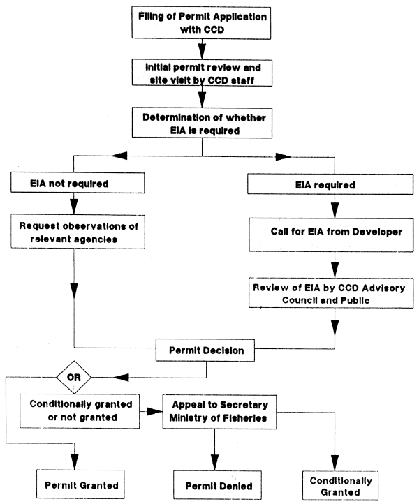
Figure 8.1 Sri Lanka Coast Conservation Department Procedure for Reviewing and Issuing Permits. Source: CCD (1988)
At the centre of the development review and control process is the formal assessment of impacts predicted for specific projects - the “environmental assessment” (EA). The information and analysis generated in the EA provide the basis for the decision on whether a coastal project is approved as is, or approved with conditions attached, or not approved. EA is used to predict the environmental effects of a project or a programme, providing a systematic way to review coastal project impacts, to modify them to reduce negative impacts on resources, and to reject the worst of them. Lately it has become common to include economic and social considerations as part of the assessment. Nevertheless, it is still usually termed an environmental assessment (EA).
The process has been used for 15 years, and its principles, practices, methodologies, and limitations are well known (Box 8.3). Training in the field is easily available. Also there is a wide literature on EA (e.g., Burbridge and Maragos, 1985; Beanlands, 1985) some of which is most appropriate. Of particular value is a recent UNEP Regional Seas report (Jernelov and Marinov, 1990). Maragos et al. (1983), Thompson (1985), Ahmad and Sammy (1985), Beanlands (1985) and Gammon and McCreary (1988) offer further background. However, special approaches may be needed for developing countries which cannot directly apply the guidelines created for developed countries. Chua Thia-Eng (pers. comm.) suggests that regional bodies be established to creat EA guidelines appropriate to the region.
It is usually best to have two or three levels of assessment of increasing complexity; the first level is a preliminary review to see if there are potential serious impacts. If so, the project is subject to higher level, more intensive, assessments, as is done in the “AMDAL” EA procedure operating throughout Indonesia.
Economic and social impacts can be incorporated into the EA. Burbridge (1987) recommends that ecological and economic impacts be jointly evaluated. With increased perception of ecological functions, it is possible to improve the economic expression of their value to society. For example, mangroves, once considered worthless unless harvested (or made into shrimp ponds) are now seen as extremely valuable ecological resources showing the importance of balancing conservation and utilization.
Environmental impact and social impact are specially important considerations in planning regional development. A human ecology perspective takes into account traditional uses, rights, and special needs of tribal minorities. Migration and population expansion also must be considered (OAS, 1984). Regional development is premised on the concept of increased social equity (see Principle 10).
Because the ICZM process operates at the interface between land and water, there is often intense conflict between private (or quasi-private) property-based operations in shorelands and public (common) property-based activities in the tidelands and coastal waters. Thus, the ICZM process may have an important mediating role between conflicting wetside and dryside interests. This essential role should not be played out sector against sector-rather, the mediating/coordinating entity must look at all sectors with legitimate interests to find the most broadly compatible solutions. The objective of the type of integrated planning used in the ICZM process is the preparation of a comprehensive plan in which the various development sectors are assessed for their effects on the various resources in a given geographic area (of which the coastal area is one of the most distinctive).
BOX 8.3 - SOURCES AND CATEGORIES OF IMPACTS
The sources of impacts are varied and are categorized and defined in different ways by different sources. The following distinctions are made:
Naturally caused impacts - Those derived from natural systems such as global temperature changes, hurricanes (typhoons), floods, diseases which usually result in the gradual or sudden death of organisms and in which man has had no discernible input.
Non-natural impacts - These are always somehow the result of human activities which have direct or indirect effects on ecosystems.
Direct impacts-Coral collecting, trampling, spear fishing, overfishing, speed boating, trail walking and tree cutting are examples that have visible immediate effects.
Indirect (or external) impacts - Inland terrestrial activities such as deforestation, improper soil coverage, the indiscriminate use of agrichemicals all contribute to environmental degradation directly or indirectly on other coastal and marine systems.
Physical impacts - these can be natural or non-natural in origin, as well as direct or indirect and result in the physical alteration of a particular ecosystem, such as anchor damage, boat grounding on coral reef or eutrophication by sewage in a lagoon.
Ecological impacts - they may be a result of any of the above categories but pertain to a broader scale of changes with more long term effects and the possibility of permanent alterations to an ecosystem.
Socio-economic impacts-these are usually a result of a direct or indirect interaction with foreign visitors on local communities. These can result in changes in the habits of other resource users, competition for scarce resources and changes in social habits.
Technological impacts - Among many other impacts, is the introduction of new technology which may cause unemployment (retraining may be a solution).
As an example, integration may be needed among fisheries, tourism, oil and gas development, and public works where these sectors are all attempting to use the coastal zone simultaneously (Sorensen and McCreary, 1990). Both fisheries and tourism depend to a large extent on a high level of environmental quality, particularly coastal water quality. Both sectors may receive “spillover” impacts such as pollution, loss of wildlife habitat and aesthetic degradation from uncontrolled oil and gas development. In another example, fisheries may require port services similar to those on which tourism depends, an infrastructure system that supplies water, sanitation, transportation, and telecommunications. Therefore, planning for both should be integrated with that for transportation and public works sectors.
It is also clear that the 30 or so developing nations in the humid tropics with extensive mangrove forests should have a strong incentive for integrated coastal resources management. Most developing nations with extensive mangrove forests are confronted with similar stresses which threaten the sustainability of this renewable resource. Conversion of mangrove forest to aquaculture ponds or croplands often presents a particularly difficult conflict of uses (Sorensen and McCreary, 1990).
![]()
![]()
![]()