![]()
![]()
![]()
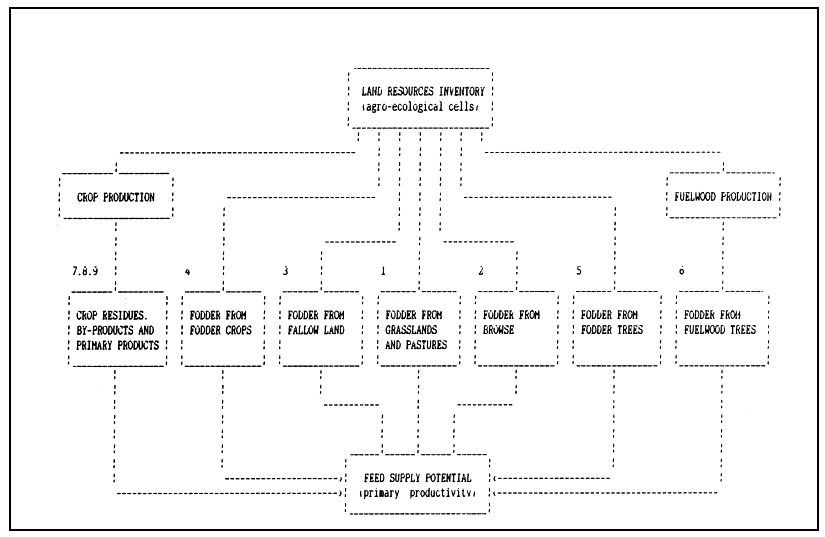
Animals require an uninterrupted and adequate supply of nutritively satisfactory feed. Part I of the livestock productivity model (Figure 2.1) deals with the estimation of feed supply from different sources. A wide variety of plant biomass is eaten by domestic herbivores. The important sources of feed biomass are the grasses, a small number of herbaceous legumes, leaves and fruits of many shrubs and trees, fodder crops, crop residues, crop byproducts and primary products (e.g. grain).
At any given location, the ecological potential of one or more of the following sources of feed needs to be quantified by agro-ecological cells of the land resources inventory (Figure 4.1).
Grassland or pastures (permanent or long-term, or short-term grass-legume mixtures, natural or sown).
Browse natural woody vegetation of shrubs and trees).
Fodder from bush and managed fallows within crop rotations natural or sown grass-legume mixture).
Fodder crops of fodder grasses, legumes and cereals (sown).
Fodder trees (sown).
Fodder from fuelwood trees (sown).
Crop residues.
Crop by-products.
Crop primary products.
Feed supplies from each of these sources are described hereunder.
FIGURE 4.1
Sources of feed supply
Biomass production potential from grasslands or pastures in the model is estimated using the FAO-AEZ method (FAO 1978), and involves the following activities (Figure 4.2):
Selection of the species and definition of land utilization types (LUTs) (e.g. species; produce; technology and input level; labour; capital; markets).
Determination of climatic requirements of species and LUTs and matching climatic requirements with the characteristics of the inventoried climatic zones (thermal zones and growing period zones), and quantifying the climatically attainable yield potentials.
Determination of edaphic (soil) requirements of species and LUTs, and matching edaphic requirements with the characteristics of the inventoried soil units, textures, phases and stoniness to rate edaphic limitations.
Quantifying soil erosion hazards (soil loss) in each climate-soil unit (agro-ecological cell) of the land resources inventory by LUT and the associated productivity losses.
Modifying the climatic yield potentials (in ii) according to the soil limitations (in iii) and erosion hazards (in iv) to quantify yield potentials with constraints and ecological land suitabilities of each inventoried climate-soil land unit for each LUT.
Each of these activities is described in the following sections.
4.2.1 Land utilization types
Considerable work has been done on screening pasture (and fodder grass and legume species) to determine those best suited to particular environments in Kenya (Edwards and Bogdan 1951; Rattray 1960; Pratt and Gwynne 1977; Boonman 1979; Jaetzhold and Schmidt 1982). Table 4.1 sets out a list of some of these pasture (and fodder species) that are considered suitable in Kenya.
Pasture production is considered at three levels of inputs. The attributes of the three levels of inputs circumstances are listed in Table 4.2, and they form the basis of the definition of land utilization types considered in the model.
4.2.2 Climatic inventory
The climatic resources inventory of Kenya (Technical Annex 1) quantifies both heat and moisture conditions.
The quantification of heat attributes has been achieved by defining reference thermal zones representing the prevailing temperature regimes1. Temperature seasonality effects of latitude are minor due to the equatorial position of Kenya.
FIGURE 4.2
Schematic presentation of suitability assessment for grassland/pasture
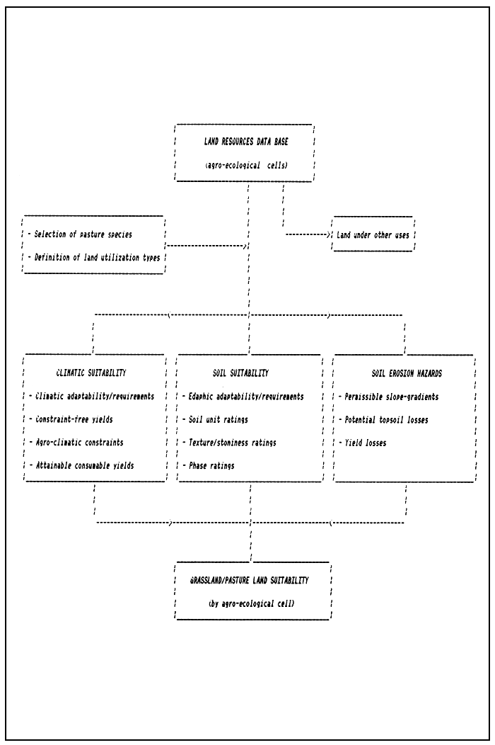
TABLE 4.1
Pasture and fodder species of grasses and legumes
| Species name | Common name | |
| Grasses: | ||
| 1 | Aristida spp. | |
| 2 | Cenchrus ciliaris | Buffel grass |
| 3 | Chloris gayana | Rhodes grass |
| 4 | Cynodon dactylon | Star grass (Bermuda grass) |
| 5 | Dactylis glomerata | Cocksfoot (Orchard grass) |
| 6 | Digitaria spp. | |
| 7 | Eragrostis superba | Masai lovegrass |
| 8 | Exotheca abyssinica1 | Exotheca |
| 9 | Fescue spp. | Fescue grass |
| 10 | Hyperrhenia spp.1 | Zebra grass |
| 11 | Lolium spp. | Rye grass |
| 12 | Melinis minutiflora | Molasses grass |
| 13 | Panicum coloratum | Coloured Guinea grass |
| 14 | Panicum maximum | Guinea grass |
| 15 | Pennisetum catabasis1 | |
| 16 | Pennisetum clandestinum | Kikuyu grass |
| 17 | Pennisetum purpureum2 | Napier grass (Elephant grass) |
| 18 | Pennisetum schimperi | |
| 19 | Setaria sphacelata | Golden timothy |
| 20 | Setaria splendida2 | Giant setaria |
| 21 | Sorghum sudanense2 | Sudan grass |
| 22 | Sporobolus helvolus1 | |
| 23 | Themeda triandra | Red oat grass |
| 24 | Tripsacum laxacum2 | Guatemala grass |
| Legumes : | ||
| 25 | Centrosema pubescens2 | |
| 26 | Desmodium spp.3 | Tick clover |
| 27 | Lablab purpureus2 | Hyacinth bean |
| 28 | Medicago sativa2 | Lucerne or alfalfa |
| 29 | Macroptilium atropurpureum3 | Siratro |
| 30 | Stylosanthes spp. | Stylo |
| 31 | Trifolium spp. | Clover |
| 32 | Vigna spp.2 |
1 Common in areas of impede drainage or in seasonally waterlogged areas.
3 Includes pasture and fodder types.
To cater for differences in temperature adaptability between species nine thermal zones (based on 2.5°C intervals) are distinguished in the climatic inventory of Kenya (Table 4.3). The temperature threshold values used in these definitions accord with those differentiating the four temperature adaptability groups of crop, pasture and tree species described in Technical Annexes 3, 4 and 6, and in Section 4.2.3.
Quantification of moisture conditions was achieved through the concept of reference length of growing period (LGP), being defined as the duration (in days) when moisture supply can permit crop growth. A moisture supply from rainfall of half, or more than half, potential evapotranspiration has been considered to permit crop growth. The following main concepts, definitions and methods form the basis of the quantification of moisture conditions in the climatic inventory.
| Attributes | Low inputs | Intermediate inputs | High inputs |
| Primary resource | Natural vegetation | Eradication of unpalatable species Legumes introduced into grassland in zones with >30 days growing period together with selective clearing .Fodder crops and legume sod seeding introduced in zones with > 90 days growing period. | Eradication of unpalatable species Legumes introduced into grassland in zones with > 30 days growing period together with selective clearing. Fodder cultivation and legume sod seeding in zones with > 90 days growing period. |
| Water | Surface water, shallow well (lifted by hand) | Boreholes and deep lined wells (windmill/engine driven pumps). | Adequate water reticulation (windmill/engine: gravity distribution) |
| Land use and feeding system | Traditional (extensive): permanent grazing; no fire control | Controlled (semi-intensive): group ranching; rotational grazing + stall feeding; fire partially controlled; fodder conservation for dry season | Controlled(intensive): control of numbers and movement; rotational semi-zero and zero grazing; fire controlled; fodder conservation for dry season. |
| Fertilization | None | In conjunction with legume introduction in region with > 90 days growing period application of ground rock phosphate and thiobacillus or superphosphate. With fodder crops intermediate levels of plant nutrients from fertilizer and manure. | Optimum amount plant nutrients. |
| Herding | Traditional | Organized | Use of hedges and fences. |
| Thermal zone code | Temperature class (°C) | Altitude (m) |
| 1 | > 25.0 | < 800 |
| 2 | 22.5 – 25.0 | 800 – 1200 |
| 3 | 20.0 – 22.5 | 1200 – 1550 |
| 4 | 17.5–20.0 | 1550 – 1950 |
| 5 | 15.0 – 17.5 | 1950–2350 |
| 6 | 12.5 – 15.0 | 2350 – 2700 |
| 7 | 10.0 – 12.5 | 2700–3100 |
| 8 | 5.0–10.0 | 3100–3900 |
| 9 | < 5.0 | > 3900 |
The growing period is the time when moisture supply from rainfall exceeds half potential evapotranspiration. It includes the time required to evapotranspire up to 100 mm of stored moisture from the soil profile. A ‘normal’ growing period has a humid phase, i.e. a period when moisture supply is greater than full potential evapotranspiration. When mere is no humid period, the growing period is defined as ‘intermediate’.
The quantification of moisture regime is based on the analysis of the length of growing period for each year seperately and the computation of:
number of seperate lengths of growing periods per year, summerized as a historical profile of pattern of number of length of growing periods per year (LGP-Pattern);
length of each growing period and its various moisture periods, summarized as mean total dominant length, first associated length and second associated length, and the mean individual dominant and associated lengths making up the total lengths;
the quality of moisture conditions during the growing period and its various moisture periods;
year-to-year variability (frequency distribution) of each length of growing period and the associated moisture condition.
Twenty two LGP-Patterns are recognized, and these with their composition are presented in Table 4.4. The LGP-Pattern code represents the number of growing periods per year in order of frequency of occurrence, e.g. in the pattern coded 2-1-3, the numeral 2 represents the number of lengths of growing periods per year (i.e. two) that occur in the majority of the years (i.e. 55 percent) - the dominant length number; the numeral 1 represents number of lengths of growing periods per year (i.e. one) that has the next most commonly occurring frequency (i.e. 25 percent) - the first associated length number; and the numeral 3 represents number of lengths of growing periods per year (i.e. three) that has the smallest occurrence (i.e. 20 percent) - the second associated length number.
For each LGP-Pattern type, the mean total length of the dominant number is correlated with the mean total length of the associated numbers. Also, when the mean total length is a summation of more than one mean length, the latter lengths are again correlated with the former total length. These relationships are presented in Tables 4.5 and 4.6.
In the climatic inventory of Kenya, only the mean total dominant length has been inventoried on the map as IS LGP zones. The boundary or isoline values used are 0, 30, 60, 90, 120, 150, 180, 210, 240, 270, 300, 330, 365- and 365+ days respectively delineating the mean total dominant length of growing period zones of 0, 1–29, 30–59, 60–89, 90–119, 120–149, 150–179, 180–209, 210–239, 240–269, 270–299, 300–329, 330–364, 365-1 and 365+2 days.
1 365- - year round growing priod but not humid year-round.
2 365+ - year-round humid growing period.
| Code | LGP-pattern | Proportion (%) |
| 1 | 1 | 100 |
| 2 | H - 1 | 60:40 |
| 3 | 1 - H | 70: 30 |
| 4 | 1 - H - 2 | 65 : 20: 15 |
| 5 | 1 - 2 - H | 65 : 20 : 15 |
| 6 | 1 - 2 | 65 :35 |
| 7 | 1 - 2 - 3 | 50:35 : 15 |
| 8 | 1 - 3 - 2 | 40 : 35 : 20 |
| 9 | 1 - 2 - D | 40 : 35 : 25 |
| 10 | 1 - D- 2 | 40 : 35 : 25 |
| 11 | 1 - D | 60:40 |
| 12 | 2 | 100 |
| 13 | 2 - 1 | 70: 30 |
| 14 | 2 - 1 - H | 55 : 30 : 15 |
| 15 | 2 - 1 - 3 | 55 : 25 : 20 |
| 16 | 2 - 3 | 75 : 25 |
| 17 | 2 - 3 - 1 | 60:25 : 15 |
| 18 | 2 - 3 - 4 | 50 : 30 : 10 |
| 19 | 2 - 1 - D | 70 : 15 : 15 |
| 20 | 3 - 2 | 60:40 |
| 21 | 3 - 2 - 1 | 50 : 35 : 15 |
| 22 | D | 100 |
H=365+ days (i.e. year-round humid)
D=zero days (i.e. year-round dry)
| LGP-Pattern | Relationship |
| 1 - 2 | L2 = 80.40 + 0.75 L1 |
| 1 - 2 - H | |
| 1 - H - 2 | |
| 1 - 2 - 3 | L2 = 71.56 + 0.66 L1 |
| 1 - 3 - 2 | L3 = 77.14 + 0.66 L1 |
| 1 - 2 - D | |
| 1 - 2 - D | |
| 2 - 1 | L1 = -86.09 + 1.28 L2 |
| 2 - 1 - H | L3 = 25.29 + 0.82 L2 |
| 2 - 1 - 3 | |
| 2 - 1 - D | |
| 2 - 3 | L3 = 30.11 + 0.83 L2 |
| 2 - 3 - 1 | L1 = -98.72 + 1.35 L2 |
| 2 - 3 - 4 | L4 = 114.54 + 0.58 L2 |
| 3 - 2 | L2 = 45.05 + 0.80 L3 |
| 3 - 2 - 1 | L1 = -9.86 + 0.88 L3 |
L1 = Total length of one growing period per year
L2 = Total length of two growing periods per year
L3 = Total length of three growing periods per year
L4 = Total length of four growing periods per year
Additionally, the LGP-Pattern zones have been inventoried. Consequently, the relationships in Tables 4.5 and 4.6 together with the map of dominant LGP zones and the LGP-Pattern zones provide the historical profile of any mean total dominant length of growing period in any of the 22 LGP-Pattern zones.
Reference tables relating the mean total dominant LGPs (mapped) and the corresponding mean total associated LGPs (unmapped) are presented in Technical Annex 1, together with generalized coefficients of variation of mean LGPs, and frequency of occurrence of intermediate LGPs.
4.2.3 Climatic suitability
Climatic suitability assessment of grass and legume pasture species is based on the climatic adaptability principles described in FAO (1978), and includes:
An understanding of the climatic adaptability of pasture species in terms of their ecophysiological characteristics.
Matching the climatic requirements to thermal and moisture regimes, including the estimation of constraint-free biomass potentials.
Rating of agro-climatic constraints of water stress/excess; pests,diseases and weeds; and work ability.
Estimating attainable biomass production potentials with constraints, and the consumable biomass fractions.
The list of grass and legume species given in Table 4.1 includes both C4 species (grasses) and C3species (legumes). Both groups of species include ecotypes that are adapted to operate under warmer (mean daily temperature > 20 °C) as well as cooler (mean daily temperature <20°C) conditions. Table 4.7 presents the thermal zone screen for pasture and fodder species showing which species can be considered in which thermal zones.
Legume species adapted to operate under cool temperatures (< 20 °C mean daily temperature) belong to adaptability group I, and those adapted to operate under warm temperatures (>20°C) belong to adaptability group II. Grass species adapted to operate under warm temperatures (>20°C) belong to adaptability group IV. The relationships between photosynthesis and temperature for the four adaptability groups are presented in Table 4.8.
Consequently, the suggested thermal zone combination ratings for the grasses and legumes at this stage of the model development are: S1 (very suitable) for the thermal zones T1, T2, T3, T4 and T5, S2 (suitable) for T6, S3 (moderately suitable) for T7, S4 (marginally suitable) for T8 and N (not suitable) for T9. A rating of S1 indicates that there are no thermal constraints during the growing period and the requirements are fully met. A rating of S2 indicates slight to moderate thermal constraints leading to yield supressions of some 25 %. A rating of S3 indicates that there are moderate to severe thermal constraints leading to yield suppressions of some 50%. A rating of S4 indicates severe thermal constraints leading to yield suppressions of some 75%. A rating of N indicates that the thermal requirements are not met and the zone is not suitable for further consideration. These ratings correspond closely with the correlation between pasture dry matter production and temperature in Kenya (Booneman 1979).
| LGP-Pattern | Relationship |
| 2 | L21 = -1.11 + 0.55 L2 |
| 1 - 2 | L21=4.94+0.62 L2 |
| 1 - 2 - H | |
| 1 - H - 2 | |
| 1 - 2 - 3 | L21 = 5.87 + 0.64 L2 |
| 1 - 3 - 2 | L31=2212+039 L3 |
| 1 - 2 - D | L32 = 1.58 + 0.32 L3 |
| 1 - D - 2 | |
| 2 - 1 | L21 = -5.48 + 0.64 L2 |
| 2 - 1 - H | L31 = 0.14 + 0.46 L3 |
| 2 - 1 - 3 | L32 = -0.98 + 0.33 L3 |
| 2 - 1 - D | |
| 2 - 3 | L21 = -3.05 + 0.61 L2 |
| 2 - 3 - 1 | L31 = 1.68 + 0.43 L3 |
| 2 - 3 - 4 | L32=-3.00+0.34L3 |
| L41 = 26.35 + 0.34 L4 | |
| L42 = -20.88 + 0.38 L4 | |
| L43 = -17.66 + 0.27 L4 | |
| 3 - 2 | L21 = -2.33 + 0.63 L2 |
| 3 - 2 - 1 | L31 = 5.62 + 0.45 L3 |
| L32 = 1.25 + 0.31 L3 |
L21 = First length of two growing periods per year
L31 = First length of three growing periods per year
L32 = Second length of three growing periods per year
L41 = First length of four growing periods per year
L42 = Second length of four growing periods per year
L43 = Third length of four growing periods per year
TABLE 4.7
Thermal zone screen for pasture and fodder species
| Species name | Adaptability group | Thermal zone | ||||||||
| T1 | T2 | T3 | T4 | T5 | T6 | T7 | T8 | |||
| Grasses: | ||||||||||
| 1 | Aristida spp. | III | • | • | • | |||||
| 2 | Cenchrus ciliaris | III | • | • | • | • | ||||
| 3 | Chloris gayana | III, IV | • | • | • | • | • | |||
| 4 | Cynodon dactylon | III, IV | • | • | • | • | • | • | ||
| 5 | Dactylis glomerata | IV | • | • | • | • | ||||
| 6 | Digitaria spp. | III | • | • | • | • | ||||
| 7 | Eragrostis superba | III | • | • | • | • | ||||
| 8 | Exotheca abyssinica | IV | • | • | • | • | ||||
| 9 | Festuca spp. | IV | • | • | • | • | ||||
| 10 | Hyperrhenia spp. | III,IV | • | • | • | • | • | • | ||
| 11 | Lolium spp. | IV | • | • | • | • | ||||
| 12 | Melinis minutiflora | III, IV | • | • | • | • | ||||
| 13 | Pan/cum coloratum | III, IV | • | • | • | • | ||||
| 14 | Pan/cum maximum | III,IV | • | • | • | • | ||||
| 15 | Pennisetum catabasis | IV | • | • | • | • | ||||
| 16 | Pennisetum clandestinum | IV | • | • | • | • | ||||
| 17 | Pennisetum purpureum | III, IV | • | • | • | • | ||||
| 18 | Pennisetum schimperi | IV | • | • | • | • | • | • | ||
| 19 | Setaria sphacelata | III, IV | • | • | • | • | ||||
| 20 | Setaria splendida | III, IV | • | • | • | • | • | |||
| 21 | Sorghum sudanense | III, IV | • | • | • | • | • | |||
| 22 | Sporobolus helvolus | III | • | • | • | |||||
| 23 | Themeda triandra | IV | • | • | • | • | • | • | ||
| 24 | Tripsacum laxacum | III,IV | • | • | • | • | • | |||
| Legumes: | ||||||||||
| 25 | Centrosema pubescens | II | • | • | • | |||||
| 26 | Desmodium spp. | II | • | • | • | |||||
| 27 | Lablab purpureus | II | • | • | • | |||||
| 28 | Medicago sativa | I | • | • | • | • | • | |||
| 29 | Macroptilium atropurpureum | II | • | • | • | |||||
| 30 | Stylosanthes spp. | II | • | • | • | • | • | • | • | |
| 31 | Trifolium spp. | I | • | • | ||||||
| 32 | Vigna spp. | II | • | • | • | |||||
| Adaptability group | Temperature (°C) | |||||||
| 5 | 10 | 15 | 20 | 25 | 30 | 35 | 40 | |
| Legume | 2.5 | 10.0 | 20.0 | 25.0 | 25.0 | 20.0 | 10.0 | 5.0 |
| Legume II | - | 2.5 | 15.0 | 35.0 | 37.5 | 37.5 | 30.0 | 20.0 |
| Grass III | - | 2.5 | 30.0 | 40.0 | 50.0 | 50.0 | 47.5 | 40.0 |
| Grass IV | 2.5 | 15.0 | 37.5 | 50.0 | 50.0 | 37.5 | 25.0 | 10.0 |
Potential biomass estimates were derived according to the method developed by the FAO-AEZ project (Kassam 1977; FAO 1978–81). For the purpose of computing constraint-free' biomass potential, it is assumed that both C3 and C4 pasture and fodder species of grasses and legumes will be represented, so that maximum photosynthesis rate (Pm) of 37.5 CH2O ha-1 hr-1 has been applied.
Estimates of constraint-free total biomass (Bn) at high level of inputs are presented in Table 4.9 together with maximum leaf area index (LAI) values used, the agro-climatic constraint ratings, total biomass with constraints (Bnc), consumable coefficients (Cc) and consumable biomass with constraints (Bcc).
For a variety of reasons only a portion of the plant biomass is eaten by animals. About 20% of the total net biomass (Bn) is in roots, a portion of the biomass is not eaten (particularly under low inputs) due to low palatability; some biomass is lost due to trampling, fire and wind, and part is consumed by invertebrate animals. It is generally assumed that between a third and two-thirds of the total biomass yield of an area will be utilized or consumed by stock, depending on the environment.
Agro-climatic constraints applied to the constraint-free yield relate to water stress in LGP < 210 days and workability in LGP zone 365+ days. Total biomass yield with constraint at high inputs range from 0.5 t/ha in LGP zone 1–29 days to 30.6 t/ha in LGP zone 330–364 days.
Consumable coefficients (Cc) range from 0.35 at low inputs in LGP zones with < 120 days to 0.6 at high inputs in LGP zones with > 180 days. Consequently, consumable biomass with constraints (Bcc) range from 0.23 t/ha to 18.9 t/ha for high inputs, from 0.16 to 10.83 t/ha for intermediate inputs, and from 0.09 t/ha to 3.94 t/ha for low inputs.
Constraint-free net biomass (Bn) at low inputs is assumed to be 25% and 50% of those at high input level in the LGP zones > 90 days and < 90 days respectively. Constraint-free total biomass at intermediate level is assumed to be between the high and the low input levels. For areas with no growing period Bc is estimated at 70 kg/ha at the high inputs level and 35 kg/ha at the low and 52.5 kg/ha at the intermediate inputs level.
Pasture species and biomass potentials are matched to individual component length of growing periods, i.e. L1, L21, L22, L31, L32, L33, L41, L42, L43, L44. The LGP-Pattern evaluation for pasture is achieved by taking into account all the constituent component lengths in each LGP-Pattern, thus taking into account the year-to-year variability in the number of LGPs per year.
Yields in Table 4.9 apply to normal lengths of growing periods. For intermediate growing periods, yield reductions are of the order of 50% on all soils except Fluvisols and Gleysols. The percentage of occurrence of intermediate lengths of growing periods in all LGP-Pattern zones combined is 100% in LGP zone 1–29 days; 65% in zone 30–59 days; 25% in zone 60–89 days; 10% in zone 90–119 days and 5% in zone 120–149 days.
An exception to the general methodology for climatic suitability assessment applies to areas occupied by Fluvisols because the inventoried length of growing period does not fully reflect their particular circumstances with regards to moisture regime.
TABLE 4.9
Potential biomass from pasture and fodder grasses and legumes (t/ha dry weight) at three input levels1
| 1–29 | 30–59 | 60–89 | 90–119 | 120–149 | 150–179 | 180–209 | 210–239 | 240–269 | 270–299 | 300–329 | 330–364 | 365- | 365 + | |
| LAI | 1–2 | 2–3 | 3–4 | 4 | 4 | 4 | 4 | 4 | 4 | 4 | 4 | 4 | 4 | 4 |
| Bn | 0.0–1.8 | 1.8–5.3 | 5.3–10.0 | 10.0–14.3 | 14.3–17.2 | 17.2–19.7 | 19.7–22.1 | 22.1–24.3 | 24.3–26.3 | 26.3–28.2 | 28.2–29.7 | 29.7–31.5 | 31.5 | 31.5 |
| a1 | 2 | 2 | 2 | 1 | 1 | 1 | 1 | 0 | 0 | 0 | 0 | 0 | 0 | 0 |
| b | 0 | 0 | 0 | 0 | 0 | 0 | 0 | 0 | 0 | 0 | 0 | 0 | 0 | 0 |
| c | 0 | 0 | 0 | 0 | 0 | 0 | 0 | 0 | 0 | 0 | 0 | 0 | 0 | 0 |
| d | 0 | 0 | 0 | 0 | 0 | 0 | 0 | 0 | 0 | 0 | 0 | 0 | 0 | 1 |
| Bnc | 0.5 | 1.8 | 3.8 | 9.1 | 11.8 | 13.8 | 15.7 | 23.2 | 25.3 | 27.3 | 29.0 | 30.6 | 31.5 | 23.6 |
| Cc - H2 | 0.45 | 0.45 | 0.45 | 0.45 | 0.50 | 0.50 | 0.60 | 0.60 | 0.60 | 0.60 | 0.60 | 0.60 | 0.60 | 0.60 |
| - 1 | 0.40 | 0.40 | 0.40 | 0.40 | 0.45 | 0.45 | 0.55 | 0.55 | 0.55 | 0.55 | 0.55 | 0.55 | 0.55 | 0.55 |
| - L | 0.35 | 0.35 | 0.35 | 0.35 | 0.40 | 0.40 | 0.50 | 0.50 | 0.50 | 0.50 | 0.50 | 0.50 | 0.50 | 0.50 |
| Bcc -H | 0.23 | 0.81 | 1.71 | 4.10 | 5.90 | 6.80 | 9.42 | 13.92 | 15.18 | 16.38 | 17.40 | 18.36 | 18.90 | 14.16 |
| - 1 | 0.16 | 0.54 | 1.14 | 2.28 | 3.32 | 3.88 | 5.40 | 7.98 | 8.70 | 9.38 | 9.97 | 10.52 | 10.83 | 8.07 |
| - L | 0.09 | 0.32 | 0.67 | 0.80 | 1.18 | 1.38 | 1.96 | 2.90 | 3.16 | 3.41 | 3.63 | 3.82 | 3.94 | 2.96 |
2 H = high inputs; I = intermediate inputs; L = low inputs.
| Inputs level | Growth period (days) | Maximum yield (t/ha) | Length of growing period | |||||||
| 0 | 1–29 | 30–59 | 60–89 | 90–119 | 120–149 | 150–179 | 180–209 | |||
| High | 30–365 | 18.90 | S6 | S5 | S4 | S4 | S3 | S3 | S2 | S2 |
| Intermediate | 30–365 | 10.83 | S6 | S5 | S4 | S4 | S3 | S3 | S2 | S2 |
| Low | 30–365 | 3.94 | S6 | S5 | S4 | S4 | S3 | S3 | S2 | S2 |
| Inputs level | Growth period (days) | Maxi- mum yield (t/ha) | Length of growing period | |||||||
| 210–239 | 240–269 | 270–299 | 300–329 | 330–364 | 365– | 365+ | ||||
| High | 30–365 | 18.90 | S2 | S3 | S4 | S4 | S4 | S4 | S5 | |
| Intermediate | 30–365 | 10.83 | S2 | S3 | S4 | S4 | S4 | S4 | S5 | |
| Low | 30–365 | 3.94 | S2 | S3 | S4 | S4 | S4 | S4 | S5 | |
Land use on Fluvisols is generally governed by the depth, intensity and duration of flooding which occurs in the low lying areas of these soils. These flooding attributes are generally controlled not by the amount of ‘on site’ rainfall but by external factors of catchment area and catchment-site relationships.
Fluvisols ratings are presented in Table 4.10 for the three levels of inputs circumstances. Suitability ratings S1, S2, S3, S4, S3, S6 and N, correspond to potential biomass yield supressions of zero, 25%, 50%, 75%, 90%, 95% and 100% respectively.
4.2.4 An example of biomass calculation
An example of the calculation of constraint-free total net biomass and constraint-free consumable biomass for Lamu (with thermal suitability S1) is presented below.
Net biomass (Bn) is calculated from the equation:
| Bn = (0.36 bgm × L) / (1/N + 0.25 Ct) | (4.1) |
where:
| bgm | = | maximum rate of gross biomass production at leaf area index (LAI) of 5 (kg CH2O ha1 day1) |
| L | = | maximum growth ratio, equal to the ratio of bgm at actual LAI to bgm at LAI of 5. (L at LAI 1, 2, 3, 4 and 5 is 0.4, 0.6, 0.8, 0.9 and 1.0 respectively) |
| N | = | length of crop growth cycle (days) |
| Ct | = | maintenance respiration coefficient, dependent on both crop and temperature; given by the relation: |
Ct = C30 (0.0044 + 0.0019 T + 0.0010 T2)
At 30 °C, C = 0.0283 for a legume species and 0.0108 for a non-legume species.
| Lat.North | Jan | Feb | Mar | Apr | May | Jun | Jul | Aug | Sep | Oct | Nov | Dec | |
| Lat.South | Jul | Aug | Sep | Oct | Nov | Dec | Jan | Feb | Mar | Apr | May | Jun | |
| O° | Ac | 343 | 360 | 369 | 364 | 349 | 337 | 342 | 357 | 368 | 365 | 349 | 337 |
| be | 413 | 424 | 429 | 426 | 417 | 410 | 413 | 422 | 429 | 427 | 418 | 410 | |
| bo | 219 | 226 | 230 | 228 | 221 | 216 | 218 | 225 | 230 | 228 | 222 | 216 | |
| 10° | Ac | 299 | 332 | 359 | 375 | 377 | 374 | 375 | 377 | 369 | 345 | 311 | 291 |
| be | 376 | 401 | 422 | 437 | 440 | 440 | 440 | 439 | 431 | 411 | 385 | 370 | |
| bo | 197 | 212 | 225 | 234 | 236 | 235 | 236 | 235 | 230 | 218 | 203 | 193 |
Constraint-free consumable biomass (Be) is calculated from constraint-free total net biomass (Bn) from the equation:
| Bc = Cc × Bn | (4.2) |
where: Cc = Consumable coefficient, i.e. consumable portion of the total net biomass Bn (equivalent to harvest index in field crops).
The maximum rate of gross biomass production (bgm) is dependent on the maximum photosynthesis (Pm) which is dependent on temperature and photosynthesis pathway of the crop. Maximum rates of photosynthesis (Pm) for pasture species of grasses and legumes is taken as 37.5 kg CH2O ha-1 hr-1 (Table 4.8).
For Pm = 20 kg CH2O ha-1 hr-1 and LAI of 5, bgm is calculated from the equation:
| bgm = F × bo + (1-F) bc | (4.3) |
where:
| F | = | fraction of the daytime the sky is clouded: |
| F | = | (Ac - 0.5 Rg)/(0.8 Ac) where Ac is the maximum active incoming shortwave radiation on clear days in cal cm-2 day-1 (Table 4.11) and Rg is the incoming shortwave radiation in cal cm-2 day-1 |
| bo | = | gross dry matter production rate of a standard crop for a given location on a completely overcast day, kg CH20 ha-1day-1(Table 4.11) |
| be | = | gross dry matter production rate of standard crop for a given location on a clear (cloudless) day, kg CH20 ha1 day1 (Table 4.11). |
When Pm is greater than 20 kg CH2O ha-1 hr-1, bgm is given by the equation:
| bgm = F(0.8 + 0.01 Pm)bo + (1 - F)(0.5 + 0.025Pm)bc. | (4.4) |
When Pm is less than 20 kg CH2O ha-1 hr-1, bgm is given by the equation:
| bgm = F(0.5 + 0.025Pm)bo + (1 - F)(0.05Pm)bc. | (4.5) |
Climate:
Station: Lamu
Location: 2° 16' S and 40° 54' E
Altitude: 30 m
Growing period: 140 days
Start growing period: 5 April
End growing period: 25 August
Average radiation (Rg): 471 cal cm-2 day
Average day-time temperature: 26.S °C
Average 24hr mean temperature: 25.3 °C
Species adaptability:
Pasture species (grasses and legumes)
Growth cycle: 140 days (equal to growing period)
Leaf area index at maximumm growth rate: 4
Consumable coefficient: 0.50
Species adaptability: Photosynthesis pathway C3/C4, groups II and III
Calculation of rate of gross biomass production (bgm)
Photosynthesis rate Pm at 26.5 °C: 37.5 kg CH2O ha-1 hr-1. Difference in Pm
relative to Pm = 20 kg CH2O ha-1 hr-1: 87.5%.
Average photosynthetically active radiation on clear days (Ac): 351 cal cm-2 day-1(Table 4.11).
Fraction of the day-time when the sky is overcast (F): 0.41 (from equation F = (Ac - 0.5Rg)/0.8Ac).
Average rate of gross biomass production for perfectly clear days at Pm = 20 kg CH2O ha-1 hr-1 (bc): 418 kg CH20 ha-1 hr-1 (Table 4.11).
Average rate of gross biomass production for totally overcast days at Pm = 20 kg CH2O ha-1 hr-1 (bo): 222 kg CH2O ha-1 hr-1 (Table 4.11).
Rate of gross biomass production at Pm = 20 kg CH2O ha-1 hr-1 at LAI of 5 : 324 kg CH2O ha-1 day-1(from equation 4.3).
Rate of gross biomass production at Pm = 35 kg CH2O ha-1 hr-1 at LAI of 5 (bgm): 426 kg CH2O ha-1day-1 (from equations 4.3 and 4.4), and 383 kg CH2O ha-1 day-1 at LAI of 4.
Calculation of total constraint-free net biomass production (Bn) and constraint-free consumable biomass (Bc)
Maintenance respiration coefficient at 30 °C: 0.0196 (for mixture of legumes and non-legumes).
| Symbol | Name | Symbol | Name | Symbol | Name |
| A | Acrisols | Gm | Mollic Gleysols | Od | Dystric Histosols |
| Ac | Chromic Acrisols | Gv | Vertic Gleysols | Q | Arenosols |
| Ag | Gleyic Acrisols | Hg | Gleyic Phaeozems | Qa | Albic Arenosols |
| Ah | Humic Acrisols | Hh | Haplic Phaeozems | Qc | Cambic Arenosols |
| Aic | Ferralo-chromic Acrisols | Hnl | Nito-luvic Phaeozems | Qf | Ferralic Arenosols |
| Aif | Ferralo-ferric Acrisols | Hol | Orthic-luvic Phaeozems | Qkc | Calcaro-cambic |
| Aio | Ferralo-orthic Acrisols | Hrl | Chromic-luvic Phaeozems | Arenosols | |
| Ao | Orthic Acrisols | Hth | Ando-haplic Phaeozems | Ql | Luvic Arenosols |
| Ap | Plinthic Acrisols | Htl | Ando-luvic Phaeozems | R | Regosols |
| Ath | Ando-humic Acrisols | Hvl | Verto-luvic Phaeozems | Rc | Calcaric Regosols |
| B | Cambisols | I | Lithosols | Rd | Dystric Regosols |
| Bc | Chromic Cambisols | Ir | Ironstone soils | Re | Eutric Regosols |
| Bd | Dystric Cambisols | J | Fluvisols | Rtc | Ando-calcaric Regosols |
| Be | Eutric Cambisols | Jc | Calcaric Fluvisols | S | Solonetz |
| Bf | Ferralic Cambisols | Je | Eutric Fluvisols | Sg | Gleyic Solonetz |
| Bg | Gleyic Cambisols | Jt | Thionic Fluvisols | Slo | Luvo-orthic Solonetz |
| Bh | Humic Cambisols | Kh | Haplic Kastanozems | Sm | Mollic Solonetz |
| Bk | Calcic Cambisols | L | Luvisols | So | Orthic Solonetz |
| Bnc | Nito-chromic Cambisols | La | Albic Luvisols | Th | Humic Andosols |
| Btc | Ando-chromic Cambisols | Lc | Chromic Luvisols | Tm | Mollic Andosols |
| Bte | Ando-eutric Cambisols | Lf | Ferric Luvisols | Tv | Vitric Andosols |
| Bv | Vertic Cambisols | Lg | Gleyic Luvisols | U | Rankers |
| Ch | Haplic Chernozems | Lic | Ferralo-chromic Luvisols | V | Vertisols |
| Ck | Calcic Chernozems | Lif | Ferralo-ferric Luvisols | Vc | Chromic Vertisols |
| Ec | Cambic Renzinas | Lio | Ferralo-orthic Luvisols | Vp | Pellic Vertisols |
| Eo | Orthic Renzinas | Lk | Calcic Luvisols | W | Planosols |
| F | Ferralsols | Lnc | Nito-chromic Luvisols | Wd | Dystric Planosols |
| Fa | Acric Ferralsols | Lnf | Nito-ferric Luvisols | We | Eutric Planosols |
| Fh | Humic Ferralsols | Lo | Orthic Luvisols | Wh | Humic Planosols |
| Fnh | Nito-humic Ferralsols | Lv | Vertic Luvisols | Ws | Solodic Planosols |
| Fnr | Nito-rodic Ferralsols | Mo | Orthic Greyzems | Wve | Verto-eutric Planosols |
| Fo | Orthic Ferralsols | Mvo | Verto-orthic Greyzems | X | Xerosols/Yermosols |
| Fr | Rodic Ferralsols | Nd | Dystric Nitosols | Xh | Haplic Xero/Yermosols |
| Fx | Xanthic Ferralsols | Ne | Eutric Nitosols | Xk | Calcic Xero/Yermosols |
| G | Eutric Gleysols | Nh | Humic Nitosols | Xy | Gypsic Xero/Yermosols |
| Gc | Clacaric Gleysols | Nm | Mollic Nitosols | Z | Solonchaks |
| Gd | Dystric Gleysols | Nth | Ando-humic Nitosols | Zg | Gleyic Solonchaks |
| Ge | Eutric Gleysols | Nve | Verto-eutric Nitosols | Zo | Orthic Solonchaks |
| Gh | Humic Gleysols | Nvm | Verto-mollic Nitosols | Zt | Takyric Solonchaks |
Maintenance respiration coefficient at 25.3 (Ct) °C: 0.014 (from equation Ct = C30 (0.0044 + 0.0019 T + 0.0010 T2)
Net total biomass (Bn): 15.5 t/ha (equation 4.1).
Consumable biomass (Be)1: 7.7 t/ha (equation 4.2).
4.2.5 Soil inventory The soil resources of Kenya (Technical Annex 1) have been inventoried in terms of associations of soil units, and the corresponding characterization of soil textures, stoniness, phases, and slopes.
1 Without agro-climatic constraints (with constraints 5.8 t/ha).
Soil units have been defined in terms of measurable and observable properties of the soil itself, and specific clusters of such properties are combined into ‘diagnostic horizons’ and ‘diagnostic properties’, which are used in the definition of the soil units. The soil units inventoried in the Kenya soil resources inventory (Exploratory Soil Map of Kenya) are listed in Table 4.12 and the diagnostic horizons and properties of these soil units are presented in the Technical Annex 1.
Soil texture may vary within the range of textures defined for a particular soil unit. In the legend of the Exploratory Soil Map, textural classes for the individual soil units by soil mapping unit are presented. The three major textural divisions (coarse, medium and fine) are subdivided into 17 classes (Table 4.13).
Soil phases indicate land characteristics which are not considered in the definition of the soil units but are significant to the use and management of land. Soil phases recognized on the Exploratory Soil Map of Kenya can be grouped into phases indicating a mechanical hindrance or limitation (rocky, bouldery, boulder-mantle, stony, stone-mantle, gravelmantle), phases indicating an effective soil depth limitation (lithic, paralithic, petro-calcic, piso-calcic, petro-ferric, piso-ferric), and phases indicating a physico-chemical limitation (saline, sodic and saline-sodic). Soil phases occur either individually or in combinations of upto three. They are described in Technical Annex 2, and are listed in Table 4.14.
| Texture symbol | Texture class |
| Coarse: | |
| S | Sand |
| LCS | Loamy coarse sand |
| FS | Fine sand |
| LFS | Loamy fine sand |
| LS | Loamy sand |
| Medium | |
| FSL | Fine sandy loam |
| SL | Sandy loam |
| L | Loam |
| SCL | Sandy clay loam |
| SL | Silty loam |
| CL | Clay loam |
| SIL | Silty clay loam |
| SI | Silt |
| Fine: | |
| SC | Sandy clay |
| SIC | Silty clay |
| PC | Peaty clay |
| C | Clay |
The presence of coarse material (stoniness) in the soil profile has been inventoried seperately from soil textures. Six types of coarse material or stoniness have been inventoried: Gravelly (G), Very Gravelly (VG), Stony (S), Bouldery (B), Stony/Bouldery (SB) and Bouldery/Stony (BS).
Six basic slope classes, in 12 combinations, have been employed in the Exploratory Soil Map of Kenya. The six basic slope classes are: A: 0–2%; B: 2–5%; C: 5–8%; D: 8–16%; E: 16–30% and F: > 30%. The 12 combination slope classes are: A: 0–2%; AB: 0–5%; B: 2–5%; BC: 2–8%; C: 5–8%; BCD: 2–16%; CD: 5–16%; D: 8–16%; DE: 8–30%; E: 16–30%; EF: 16->30%; F: >30%.
To each of these 12 slope classes, associated slope classes have been assigned. These associated slope classes, covering upto 10% of the land area of the 12 slope classes, are used for evaluation purposes only. They are not included explicitly in the soil resources inventory. The 12 inventoried combination slope classes and the associated slope classes are presented in Table 4.15 For the same purposes of evaluation, assumed mean slopes have been assigned to each of the quartiles of the land area of each of the 12 slope classes (Table 4.16).
| Symbol | Name | Symbol | Name | Symbol | Name |
| Single: | Combination of two: | Combination of three: | |||
| R | Rocky | R/B | Rocky and bouldery | R/B/AO | Rocky and bouldery and saline-sodic |
| B | Bouldery | R/S | Rocky and stony | R/P/S | Rocky and lithic and stony |
| BM | Boulder-mantle | B/S | Bouldery and stony | B/S/A | Bouldery and stony and saline |
| S | Stony | BM/AO | Boulder-mantle and saline-sodic | BM/S/AO | Bouldery and stony and saline-sodic |
| SM | Stone-mantle | S/R | Stony and rocky | P/R/B | Lithic and rocky and bouldery |
| G | Gravelly | S/B | Stony and bouldery | P/B/S | Lithic and rocky and stony |
| GM | Gravel-mantle | S/K | Stony and petrocalcic | P/B/A | Lithic and bouldery end saline |
| P | Lithic | S/AO | Stony and saline-sodic | P/BM/AO | Lithic and bouldery-mantle and saline sodic |
| PP | Paralithic | SM/O | Stone-mantle and sodic | P/S/R | Lithic and stony and rocky |
| K | Petrocalcic | SM/AO | Stone-mantle and saline-sodic | P/S/A | Lithic and stony and saline |
| KK | Petrocalcic | P/R | Lithic and rocky | P/S/AO | Lithic and stony and saline-sodic |
| C | Pisocalcic | P/B | Lithic and bouldery | P/SM/AO | Lithic and stone-mantle and saline-sodic |
| C C | Pisocalcic | P/BM | Lithic and boulder-mantle | P/GM/S | Lithic and gravel-mantle and saline |
| M | Petroferric | P/S | Lithic and stony | ||
| MM | Pisoferric | P/O | Lithic and sodic | ||
| A | Saline | P/AO | Lithic and saline-sodic | ||
| O | Sodic | PP/R | Paralithic and rocky | ||
| AO | Saline-sodic | PP/S | Paralithic and stony | ||
| F | Fragipan | K/S | Petrocalcic and stony | ||
| K/A | Petrocalcic and saline-sodic | ||||
| KK/A | Petrocalcic and saline | ||||
| KK/O | Petrocalcic and sodic | ||||
| N/R | Pisoferric and rocky | ||||
| N/M | Pisoferric and pisoferric | ||||
| A/F | Pisoferric end fragipan | ||||
| O/F | Sodic and fragipan | ||||
TABLE 4.15
Associated slope classes
| Slope class | Associated slope classes | |||
| Symbol | % | |||
| A | 0–2 | 100% A | ||
| AB | 0–5 | 100%AB | ||
| B | 2–5 | 100%B | ||
| BC | 2–8 | 90%BC | 5%A | |
| C | 5–8 | 90%C | 5%AB | 5%D |
| BCD | 2–16 | 90% | 5%A | 5%D |
| CD | 5–16 | 90%CD | 5%AB | 5%E |
| D | 8–16 | 90%D | 5%BC | 5%E |
| DE | 8–30 | 90%DE | 5%BC | 5%E |
| E | 16–30 | 90%E | 5%BCD | 5%F |
| EF | 16–56 | 95%EF | 5%BCD | 5%F |
| F | 30–56 | 95% F | 5% DE | |
4.2.6 Edaphic suitability
As a medium in which roots grow and as a reservoir for water and nutrients upon which plants continuously draw, soil represents an important natural resource and valuable economic asset requiring protection and improvement through good land use husbandry.
The adequate exploitation of the climatic potential or sustained maintenance of productivity largely depends on soil fertility and using soil on an ecologically sound basis. Soil fertility is concerned with the ability of soil to supply nutrients and water as well as the ability of soil to respond to application of production treatments. The fertility of a soil is determined by both its physical and chemical properties whose understanding is essential to the effective utilization of the climatic resources.
TABLE 4.16
Quartiles of slope classes
| Slope class | Gentlest | Lower | Upper | Steepest | |
| Symbol | % | Q1 | Q2 | Q3 | Q4 |
| A | 0–2 | 0 | 1 | 1 | 2 |
| AB | 0–5 | 0 | 2 | 4 | 5 |
| B | 2–5 | 2 | 3 | 4 | 5 |
| BC | 2–8 | 2 | 4 | 6 | 8 |
| C | 5–8 | 5 | 6 | 7 | 8 |
| BCD | 2–16 | 2 | 6 | 11 | 16 |
| CD | 5–16 | 5 | 9 | 12 | 16 |
| D | 8–16 | 8 | 11 | 13 | 16 |
| DE | 8–30 | 8 | 16 | 22 | 30 |
| E | 16–30 | 16 | 21 | 25 | 30 |
| EF | 16–56 | 16 | 30 | 42 | 56 |
| F | 30–56 | 30 | 39 | 47 | 56 |
In order to assess soil suitability for pasture production, the soil requirements of pasture species must be determined. Further, these requirements must be understood within the context of limitations imposed by landform and other features (e.g. soil phases, stoniness) which do not form part of soil composition but have a significant influence on the use that can be made of the soil.
Basic soil requirements for pasture species relate to the following internal soil properties:
the soil temperature regime, as a function of the heat balance of soils as related to annual or seasonal and/or daily temperature fluctuations;
the soil moisture regime, as a function of the water balance of soils as related to the soil's capacity to store, retain, transport and release moisture for plant growth, and/or to the soil's permeability and drainage characteristics;
the soil aeration regime, as a function of the soil air balance as related to its capacity to supply and transport oxygen to the root zone and to remove carbon dioxide;
the natural soil fertility regime, as related to the soil's capacity to store, retain and release plant nutrients in such kinds and proportions as required by pasture species during growth;
the effective soil depth available for root development and physical support of plants;
soil texture and stoniness at the surface and within the whole depth of soil required for normal pasture development;
the absence of soil salinity and of specific toxic substance or ions deleterious to plant growth; and
TABLE 4.17
Relations between basic soil requirements for pasture species and soil characteristics
| Basic soil requirements | Soil characteristics (soil factors) |
| Moisture availability1 | - Effective soil depth - Available soil moisture holding capacity - Drainage |
| Nutrient availability | - Nutrient availability - Soil reaction |
| Oxygen availability2 | - Soil permeability, Drainage |
| Foothold for roots | - Effective soil depth |
| Salinity | - Soil salinity |
| Toxicity | - Soil reaction3 |
| Accessibility and trafficability (workability) | - Topsoil consistency and bearing capacity |
| Soil tilth for species establishment | - Topsoil consistency and bearing it |
1 Moisture availability is influenced by climatic factors.
2Oxygen availability is influenced by inundation and flooding characteristics.
3Chemical properties of soil parent material may also be involved in some cases.
other specific properties, e.g. soil tilth as required for germination and early plant growth.
From the basic soil requirements for pasture species, a number of responses related to soil characteristics have been derived. The correlation between the basic soil requirements listed above and soil characteristics that can be used as soil factors to rate pasture and fodder crop performance is given in Table 4.17.
As explained earlier, the soil units (Table 4.12) have been defined in terms of measurable and observable properties of the soil itself, and specific clusters of such properties are combined into “diagnostic horizons” and “diagnostic properties”, which are used in the definition of the soil units.
The diagnostic horizons have been used as defined in the FAO-Unesco Soil Map Legend. Diagnostic properties however have been narrowed down in case of ferric properties and widened in case of vertic properties. In Table 4.18 for each soil unit diagnostic horizons and properties of the soil units are summarized. For the ease of interpretation of Table 4.18, these characteristics are summarized below.
| Histic H horizon: | Surface layer of organic material more than 20 cm thick. |
| Mollic A horizon: | Surface horizon with dark colour, medium to high humus content, high base saturation. |
| Umbric A horizon: | Surface horizon with dark colour, medium to high humus content, low base saturation. |
| Ochric A horizon: | Surface horizon with light colour, low humus content. |
| Argillic B horizon: | Subsoil horizon with accumulation of illuvial clay. |
| Natric B horizon: | Subsoil horizon with accumulation Of illuvial clay and high exchangeable sodium. |
| Cambic B horizon: | Subsoil horizon with a structure and/or colour different from overlying and underlying horizons. |
| Spodic B horizon: | Subsoil horizon with accumulation of iron and/or humus. |
| Oxic B horizon: | Subsoil with residual accumulation of sesquioxides and low CEC |
| Calcic horizon: | Horizon of accumulation of calcium carbonate. |
| Gypsic horizon: | Horizon of accumulation of calcium sulphate. |
| Sulphuric horizon: | Horizon with strong acidity and prominent mottling. |
| Albic E horizon: | Eluvial horizon from which clay and free iron oxide have been removed, light colour. |
| Calcareous material: | Calcium carbonate present at least between 20 and SO cm from the surface. |
| CEC high or very high: | Exchange complex dominated by allophane or montmorillonite. |
| CEC low: | Exchange complex dominated by kaolinite (CEC less than 24 meq/100 g clay). |
| CEC very low: | Less than 1.5 meq/100 g clay. |
| Cracking clays: | Formation of deep and wide cracks upon drying. |
| Plinthite: | Mottled subsoil layer which irreversibly hardens upon exposure to repeated wetting and drying. |
| High salinity: | Electrical conductivity (EC) higher than 15 mmhos/cm. |
| Moderate salinity: | Electrical conductivity (EC) between 4 and 15 mmhos/cm. |
| High alkalinity: | Saturation with exchangeable sodium of more than 15%. |
| Moderate alkalinity: | Saturation with exchangeable sodium of 6 to 15%. |
| Indurated subsoil: | Subsoil layer with firm or hard consistence, but can still be penetrated by spade or auger. |
| Cemented hardpan: | Extremely hard continuous subsoil layer which cannot be penetrated by spade or auger. |
| Coarse texture: | Less than 18% clay and more than 65% sand. |
| Heavy texture: | More than 35% clay. |
| Abrupt textural change: | Considerable increase in clay content within a very short vertical distance. |
| Tonguing: | Deep and irregular penetration of an albic E horizon into an argillic B horizon. |
The edaphic suitability classification is input-specific and based on:
matching the soil requirements of pasture and fodder species with the soil conditions of the soil units described in the soil inventory (soil unit evaluation), and
modification of the soil unit evaluation by limitation imposed by texture, phase and slope conditions.
The soil unit evaluation for pasture and fodder production is expressed in terms of ratings based on how far the soil conditions of a soil unit meet the growth and production requirements under a specified level of inputs. The appraisal is effected in five basic classes for pasture and fodder grasses and legumes as a group, i.e. very suitable (S1), suitable (S2), moderately suitable (S3), marginally suitable (S4), and not suitable (N).
A rating of S1indicates that the soil conditions are optimal, and that suppression of potential yields (if any) is assumed to be nil or slight. A rating of S2 indicates that there are slight to moderate soil constraints and there would be a suppression of potential yields of the order of 25 %. A rating of S3 indicates that there are with moderate to severe soil constraints and there would a suppression of potential yields of the order of 50%. A rating of S4 indicates that there are severe soil constraints and there would be a suppression of potential yields of the order of 75%. A rating of N indicates that soil conditions are not suitable for production.
The soil unit ratings are presented in Table 4.19 and apply as indicated provided there are no additional limitations imposed by soil texture, phase and stoniness. Modifications are required where such limitations are present.
In the case of soil texture, soil unit ratings remain unchanged if the soil is an albic, cambic, ferralic, calcaro-cambic or luvic Arenosol (Q, Qa, Qc, Qf, Qkc, Q1) or a vitric Andosol (Tv), or where textures are medium (fine sandy loam, sandy loam, loam, sandy clay loam, clay loam, silty clay loam, silt), or fine (sandy clay, silty clay, peaty clay, clay). In all other cases (i.e. with coarse textures: sand, loamy coarse sand, fine sand, loamy fine sand, loamy sand) the soil unit rating is one class (25%) lower.
Limitations imposed by phase and stoniness are rated using the five basic classes already described. The phase ratings are presented in Table 4.20, and the stoniness ratings in Table 4.21.
![]()
![]()
![]()