Erosion control structures as related to water management methods
[Plates 26 and 27]
There are bound to be rainstorms whose water the soil cannot fully absorb - a point of major importance in arid and semi-arid areas, for this water can be collected and used to improve productivity locally. The following four water management methods and erosion control structures apply:
• runoff harvesting (catching runoff for supplementary irrigation);
• total absorption or infiltration;
• runoff diversion (redirecting excess water);
• runoff spreading (distribution of runoff energy).
STRUCTURES FOR RUNOFF HARVESTING
In semi-arid countries where rainfall is too sparse to allow crops to be grown on the whole slope, part is used to favour runoff, which is then retrieved lower down to irrigate smaller areas, make up for any lack in rainfall, and enhance crop security (Hudson 1990).
FIGURE 33 Tabias and spillways
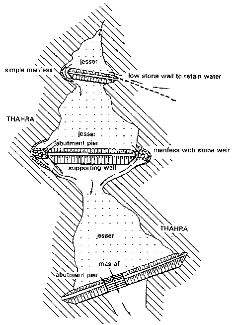
FIGURE 34 Cross-section of a tabia and its jesser (cf. Bonvallot 1986)
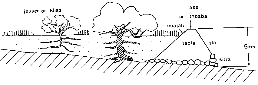
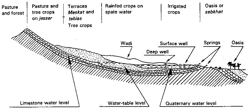
FIGURE 35 Rural land-use planning in the Maghreb as a function of hydrogeological factors (cf. Gosselin 1939)
In their work on runoff harvesting to improve crop production, Reij, Mulder and Begeman (1988) classify the available techniques as follows:
• short-distance water harvesting: microcatchments, half-moons;
• harvesting water at the bottom of a long slope: earth bunds, boulis, trapezoidal bunds, in Turkana in Kenya;
• harvesting river-water from its bed;
• diversion of wadi flows;
• dam with reservoir cropping after absorption.
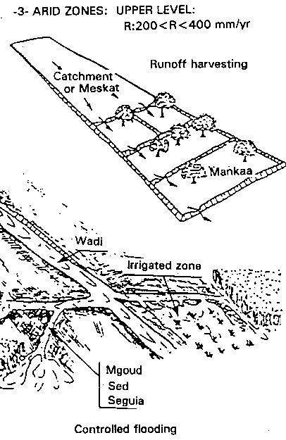
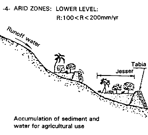
In Tunisia, Gosselin (1939) studied rural land use planning from the hydrogeological perspective (El Amani 1983). In the upper watershed, he distinguishes tabias, trapezoidal earth bunds, reinforced below with a stone wall and on the sides with a stone-lined spillway. Some 2 to 5 metres high, they bar a valley several dozen metres wide. A tabia acts as a path, behind which runoff water and loamy-sandy silt collects, bounding a jessour - a kind of well-watered field where annual crops (barley, peas, lentils, beans, water melons) are grown in the shade of trees suited to the successive silt deposits (fig, olive, pomegranate, almond) (Figures 33 and 34).
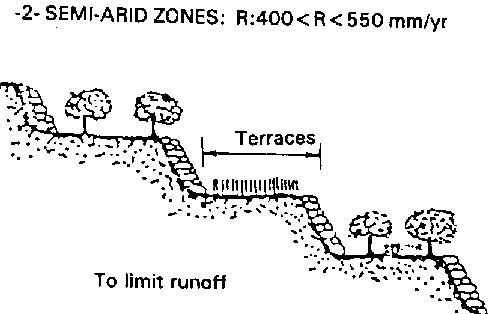
Terraces or meskats are engineered on the slopes, irrigated by channels that catch slope runoff.
Lastly, a whole series of structures in the valley allows flood spate or groundwater to be harnessed (Figures 35 and 36).
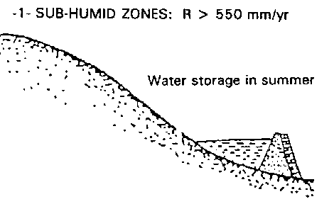
El Amani (1983) then classified traditional water management systems in terms of climate (Figure 36).
In the Sudano-Sahelian region of West Africa, most soils have a surface crust. This gives rise to particularly harmful surface runoff in these semi-arid climates, selectively carrying away organic matter and nutrients from the surface horizons.
FIGURE
36
Classification of
traditional water management systems by climate (cf. El Amani
1983)
1 - Sub-humid zones: R > 550 mm/yr
2 - Semi-arid zones: R:400 < R < 550 mm/yr
3 - Arid zones: upper level: R:200 < R < 400 mm/yr
4 - Arid zones: lower level: R:100 < R < 200 mm/yr
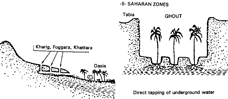
5 - Saharan zones
A whole series of traditional soil fertility and water conservation techniques can be seen in these areas in which both the water balance and the ethnic make-up vary greatly.
Many such methods are seen in operation on the broad pediments below rocky or lateritic hills used as extensive rangeland for livestock, so that these rangelands act to harvest the abundant runoff.
The Zaï method
This is a complex traditional method allowing recovery of degraded soils on broad, loamy-sandy pediments. It combines harvesting runoff with concentrating manure and available water in pans, making use of termite activity. There are many variants, including forest zaï which is particularly suitable for introducing agroforestry into a Sudano-Sahelian area (Figure 5).
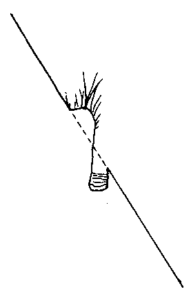
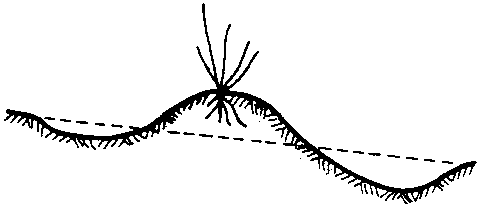
Half-moons (Figure 37)
On broad, loamy pediments which degrade very fast once the natural plant cover disappears, runoff from 10 to 20 m² can be harvested by arranging half-moon shaped bunds, 2 to 6 metres in diameter, on which cereals or trees are grown. At Ouramiza in Niger, the 20-cm-deep half-moon has a cropped area of 6 m² for a reception area of 16 m² (2-m-wide semicircles are set 4 metres apart along a contour line and 4 metres from the next contour line and there are 313 half-moons per hectare, for an estimated cost of 900 FF = 80 workdays/ha). Pans 3 × 0.6 × 0.6 m (1 m³) can also be dug to drain 10 m² one or two trees are planted at the low point (FAO Keita Valley project). There is a serious risk of clogging in these microcatchments in the case of millet and certain trees because of the suspended load in the runoff, which quickly forms fairly impermeable crusts. The use of straw or branches would allow wind-blown sand to be trapped in order to maintain a good infiltration capacity and the localized use of manure could also help.
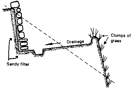
Cisterns or boulis (Figures 37, 38 and 41)
Cisterns or boulis are dug out of the broad pediment where rangeland (gravel pediment) meets cropped land (loamy pediment). Some Mossi farmers have progressively dug out water holes, cisterns or boulis 1 to 2 metres deep, using the soil removed to build a crescent-shaped bund extending over a hundred metres or so. When the first rains come, they give farmers 100 to 500 m³ of runoff water with a fairly heavy washload. The water can be used either to irrigate a small garden, which can produce two well-manured, furrow-irrigated crops of lean-season maize and late watermelons, or stock-watering so that the animals, not having to migrate to a watering point in the valley, will lose less weight at the end of the dry season. This system improves food security, especially in the lean season, but it does require a great deal of work, which can, however, be done gradually over several dry seasons with the help of a team of neighbours. The necessary labour could also be reduced by locating the boulis at the top of a gully where a great deal of runoff is concentrated before acquiring much solid matter in suspension. The latter approach would also solve the problem of treating gullies, which could become stabilized below the boulis through the simple reduction in peak flows. There are now hand pumps (e.g. ETSHER 2000 at Ouagadougou) capable of raising 10 m³ of water/day 1 metre in height.
FIGURE
37
Harvesting and storing
runoff from a semi-arid catchment (cf. Roose 1989)
Mulch (grass + twigs)
Mulch
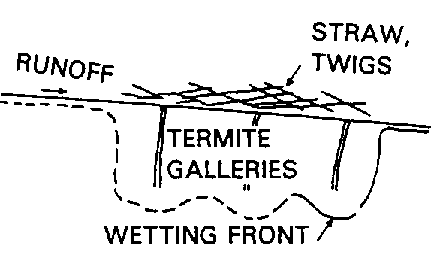
• termites will eat the organic matter
- dig galleries
- encourage penetration of runoff
- distribute nutrients
• improves infiltration and manure
Zaï (pitting + manure + termites)
Zaï
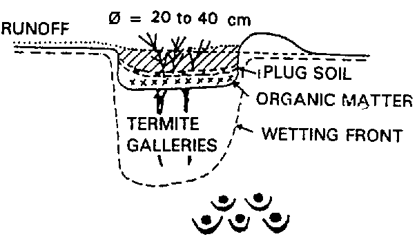
• pit 20-40 cm Ø, 10-15 cm deep. earth on downside in a crescent
(r) runoff harvested on basin 3/1
• water concentration + OM + nutrients
(r) yields > 800 kg/ha on exhausted soil
• action + + of termites on infiltration. The tunnels protect infiltrated water deom direct evapotranspiration
Half-moons (micro-catchment 1/5 to 1/10)
Half-moons
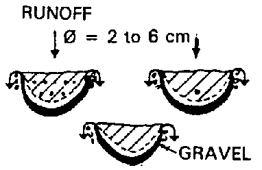
• runoff harvested on 10 to 20 m² on loamy pediments in order to irrigate:
- cereals or
- 1 or 2 trees
• the ends of the bunds are protected by three stones to prevent erosion during overflows
Boulis = a cistern dug at the foot of a pediment on the edge of rangeland
Boulis
• bund built with earth gradually extracted from the centre of the crescent
• fine sediment carried down by runoff clogs the bottom of the cistern
• 3 objectives:
- watering cattle (filtered)
- supplementary irrigation of an early-season garden (1000 m²)
- fine sediment can be recovered
(r) bricks or organic soil
FIGURE 38 Cistern and plot used to test contingency irrigation of a garden (cf. Dugue 1986)
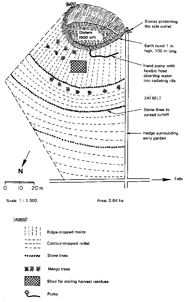
FIGURE 39 Water harvesting: experimental site at Bossomboré (Ziga, near Ouahigouya, Burkina Faso) (cf. Bedu 1986)
A number of risks must be taken into account. Erosion on the pediment above the boulis could progressively fill in the pool, and so measures are needed to keep the soil in place (lines of stones, grass strips) without reducing runoff too much. Another solution is to recover the fresh sediment for brick-making once the water falls (sun-drying them in the dry season). The bund can slide into the pool if not ringed by a paved area about 1 metre wide, and may also be damaged by livestock or rain. It can be helpful to install a paved area (or grassy vegetation) uphill of the bund, pressing the ground down well and protecting it from livestock with a thorn hedge. Livestock must not be allowed to wade in the pool itself for fear of infection from a sick animal. A drinking trough must be set up below the bund, fed by a flexible pipe that siphons the water to a filter (200-litre drum filled with alternating layers of sand and wood charcoal). The bund must be protected by blocks of laterite or tufts of perennial grass (e.g. Andropogon) to prevent erosion of the edges if it overflows.
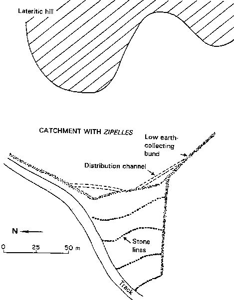
Earth bunds for water harvesting
Runoff from the surrounding hills or rangeland can also be harvested behind an earth bund and used to irrigate a field. A series of stone lines should be laid out every 20 metres (Figure 39), bringing the ratio between catchment and field below one to three in an area with 400 to 600 mm of rainfall, and slowing sheet runoff to under 25 cm/see, thus preventing gullying when a storm spreads additional water over a field that already has a tendency to runoff. However, this method of runoff management has its risks, for in dry years harvesting may not provide enough water for seeds, and in wet years the excessive water can reduce production by temporarily waterlogging the soil (Hudson 1990) and breaking down the bunds.
In the Turkana district of Kenya, Finkel (1985) worked out a simple equation to estimate the ratio between water harvesting area and cropped field:
![]()
In this semi-arid region of Kenya, the ratio (R < 200 mm) ranges from 15 to 40 for sorghum and various pulses (cf. Reij, Mulder and Begeman 1988), but the bunds have recently suffered damage in a year with high rainfall. In the 600-mm rainfall area around Ouahigouya, this ratio would be 1 to 3.
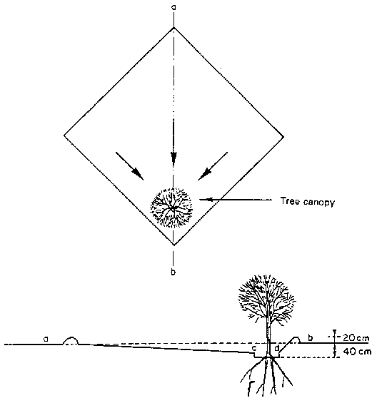
Negarim microcatchments
This is the best known system of water harvesting on short slopes in order to irrigate a tree crop (Figure 40). The basic element is a small hole, forming an absorption basin 40 cm deep, and a rim formed of a V- or half-moon-shaped earth berm 20 cm high. In a new orchard in Israel, the absorption area would be about 4 × 4 metres, while the catchment area would be three to six times larger.
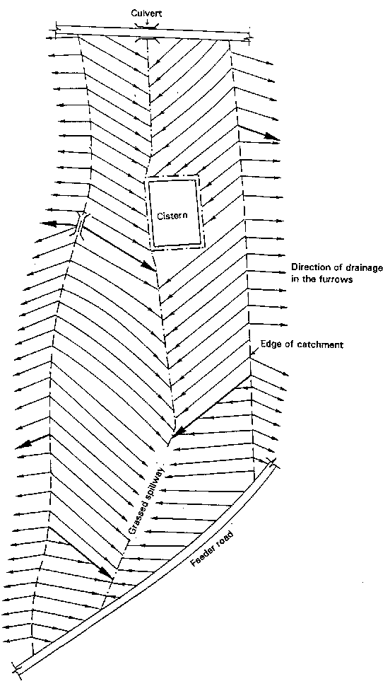
Earthen beds draining excess water into a cistern (on a vertisol)
Vertisols are very clayey and chemically fairly fertile soils extremely difficult to work in the rainy season, when they are muddy. However, they can be tilled in the dry season one month after the end of the rains, dividing the fields into a succession of beds 1.5 metres wide separated by small, gently sloping (0.5%) furrows to carry drainage water to a spillway and into a cistern dug out of the ground (Figure 41). This system allows two crops: a rainy season crop where drainage allows sorghum to grow on the beds prepared and sown before the onset of the rains; then, after the rainy season, the ground is so swollen that it has a reserve of about 400 mm of water when the vertisol is 1 metre deep. The cistern holding the runoff water contains several hundred cubic metres, which can be used only as supplementary irrigation from the fields to make up for a sudden break in the rains or the end of the season. This system, developed by ICRISAT near Hyderabad in central India, allowed farmers to double their income, although requiring considerable work at a time of year when they would rather concentrate efforts on the rice fields in the valley bottoms. This whole approach is suitable only for vertisols rich in swelling clay, and not for red, ferruginous, tropical soils, which cannot hold enough water.
FIGURE 40 Diagram of a microcatchment (cf. Evenari, Shanan and Tadmor 1968)
Conclusions Study of traditional water management methods in a given region makes it possible to choose the methods best suited to focal environmental conditions over a long period, and also closest to the habits of the people concerned. Soil
degradation from cropping probably forces the conclusion
that runoff is inevitable. So before setting up erosion
control structures it is vital to study the origin of
runoff under the different cropping methods observed in
the local area. Agricultural engineers tend to start from
the assumption that the heaviest rain cannot be absorbed,
and they therefore largely neglect cropping techniques
that would allow increased infiltration. Now, if farmers'
expectations - increased efficiency, better returns for
their labour and higher yields - are to be met, the
supply of water and minerals to crops must be enhanced,
implying a major effort to foster total absorption of
rainfall (except in special circumstances in mountainous
areas where this would entail the specific risk of
landslides). Cropping techniques such as tied ridging,
mulching or permanent cover lead to almost total rain
absorption and curb the energy of sheet runoff, in which
cases there is little point in investing in costly and
fairly ineffective erosion control structures. |
FIGURE 41 Beds drained by furrows channelling water to a grass spillway and cistern on a vertisol at the ICRISAT Hyderabad Center (cf. Kampen, Krishna and Pathak 1981)
TOTAL ABSORPTION STRUCTURES
Total absorption structures are used in two cases: when rainfall barely ensures crop evapotranspiration, and in very permeable places.
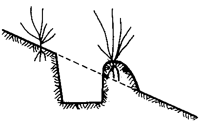
Rwandan blind ditches with grassed risers (or Kenyan Fanya Juu) (Figure 42)
FIGURE 42 Infiltration (blind) ditch with a grassed riser above it
As early as the mid-1930s in Rwanda and Burundi, the Belgians suggested digging contour ditches on slopes of less than 20% where the ferralitic soil cover is deep and very permeable and where there is little risk of landslides.
Runoff water trapped in the ditches is prevented from collecting at a low point (due to construction errors or localized fragility), and carving deep gullies, by 50-cm-thick ties marking off sections of ditch 3 m long and 60 cm deep and broad. The soil must be thrown uphill and fixed with tall grasses (Pennisetum purpureum, Setaria splendida or sphacelata, Tripsacum laxum or Vetiver) to create a gradual concave terrace.
Advantages. Infiltration (blind) ditches provide good dividers for overly-long slopes, with storage of runoff and silt that can be particularly useful in dry regions; the formation of gradual terraces can also be encouraged by throwing the earth and silt uphill and protecting the risers with plants that fix the soil in place. These ditches restock the groundwater and moisten the surroundings, so that bananas and other water-demanding trees can be planted near the ditch.
Disadvantages. This technique is restricted to deep permeable soils and slopes of less than 20% (Tondeur 1950).
• Such ditches have been widely used under the wrong conditions (shallow soils on schist or granite), and where they have failed to receive proper maintenance, gullying and landslides have been the result.
• It takes 300 days' work per hectare to dig the ditches, and 20 to 50 days of upkeep before the farmers see any clear improvement in production.
• The area occupied by the ditches (1 m every 10 to 20 m) amounts to a loss of 5 to 10% of arable land without much increase in production from the cropped strips.
• If the soil cover is shallow (on mica schist or volcanic ash on granite), these ditches increase the risk of landslides by accelerating the water's access to the slide bed-plane.
• If the soil is not very permeable or the ditches are too small, badly kept and silted up, then runoff overflows, creating the very gullies one meant to avoid.
• The vertical risers often tend to be unstable because of failure to maintain the grass strips, and especially where they are undermined by workers preparing the fields below.
FIGURE 43 Mediterranean, bench, or radical terrace
Suggestion. In order to increase stability, the risers must be re-cut, and the humus-rich top part slid down together with its plant cover onto the sterile, uncovered area. In Burundi, it has been seen that water, soil and nutrients tend to collect on these sloping banks, and that these deposits can be protected and improved by intensive forage production on the risers, and by planting trees to drain the foot and reduce the risk of sliding, and lastly by hedges or fruit bushes, cut back each year to keep the height of the riser the same.
Instead, if large trees were planted above the riser, they could easily loosen it in high winds. There is a trend away from such ditches today, with access paths being set up in their place, or those still existing being transformed into compost pits for planting bananas (Roose 1990).
Mediterranean or Bench Terraces (Figure 43)
Bench terraces are most often seen in mountains around the Mediterranean basin, but also in the Peruvian Andes, Bali (Indonesia) and China - in places where there is little level land, or where the population is dense or threatened by an invader (as in the case of the Dogons in Mali), or where work is obligatory or labour very cheap, and where products with high added value (e.g. carnations in Nice, strawberries in Spain and Lozère, kif in the central Rif and kat in the Hararghe region of Ethiopia) can be grown by irrigation and exported.
The benches are made of a subvertical riser reinforced with stones or plants, and a terrace with a slight reverse slope, with a possibility of irrigation and drainage down the slope.
Advantages:
• The benches create flat areas and suppress sheet erosion.
• They allow investment in steeply sloping land leading to greater productivity.
• They increase the available crop water.
• They make irrigation possible by harnessing mountain water and runoff on the risers.
FIGURE 44 (a) Step microterracing (b) Discontinuous forest step terracing
Disadvantages:
• They are very expensive to build, requiring 500 to 1200 days' work per hectare, and then requiring upkeep of the risers.
• They increase the risks of landslides, for they foster absorption closer to the rock; ruling them out on schist, gneiss or very shallow soil, or in areas subject to frequent earthquakes.
• Once they are built, soil fertility must be restored through massive doses of manure, lime and phosphorus if yields are to double or triple after some years; since the risers are not vertical, 20 to 50% of the land area cannot be cropped, although it can still produce forage.
• The risks of leaching of soluble nutrients are increased by reducing surface runoff.
• A lot of the topsoil is concentrated in the clods that make up the banks, which means that soil fertility must be restored before any advantage can be seen.
Proposal. This method is too expensive to be recommended for generalized use, and too hazardous on shallow soils and in areas prone to frequent earthquakes. It is at present viable only in the perspective of mechanized cropping on a site with an average slope of 15 to 30%. It is important to place tracks at the foot of the risers.
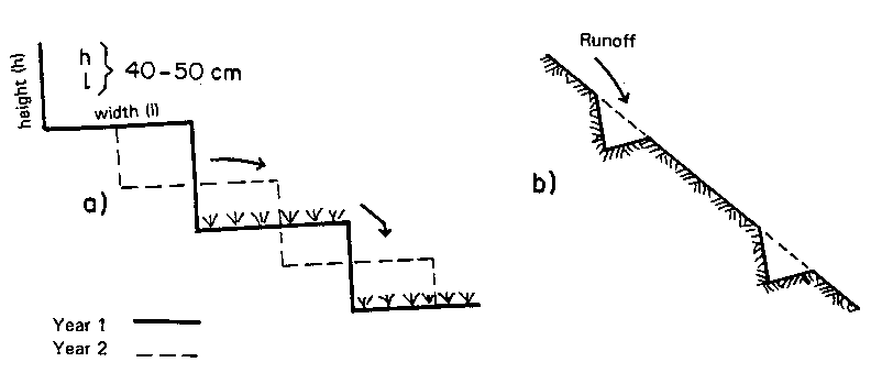
The traditional method of step microterracing (Figure 44) is directly derived from the bench terracing method, and consists of digging steps 50 cm wide, which are then moved 25 cm each year in order to keep a rough surface, and turning in the plants that grow during the fallow period. This method exerts a brake on runoff energy on slopes of up to 80%, but does not prevent the soil cover from slowly creeping downhill due to dry mechanical erosion (Rwehumbiza and Roose 1992, Hudson 1973, Fournier 1967).
There is an arid zone variant in which only part of the slope is terraced to collect runoff on the banks and encourage full absorption of rainwater and the recovery of runoff. This means that the water from most light and average rainstorms is absorbed totally by the strip of cropped soil. However, the method does envisage a drainage system allowing excess water to be evacuated during the exceptionally heavy rainstorms that are so dangerous around the Mediterranean.
Conclusion Total absorption structures offer radical solutions in semi-arid regions where plant production is closely dependent on the availability of water, and also on steep slopes where it is difficult to control runoff without creating gullies. However,
installation and upkeep of such structures require a
heavy investment. Furthermore, they cannot be installed
indiscriminately without increasing the risks of
landslides and the leaching of nutrients. |
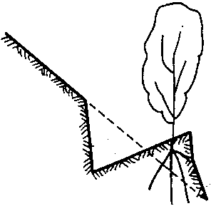
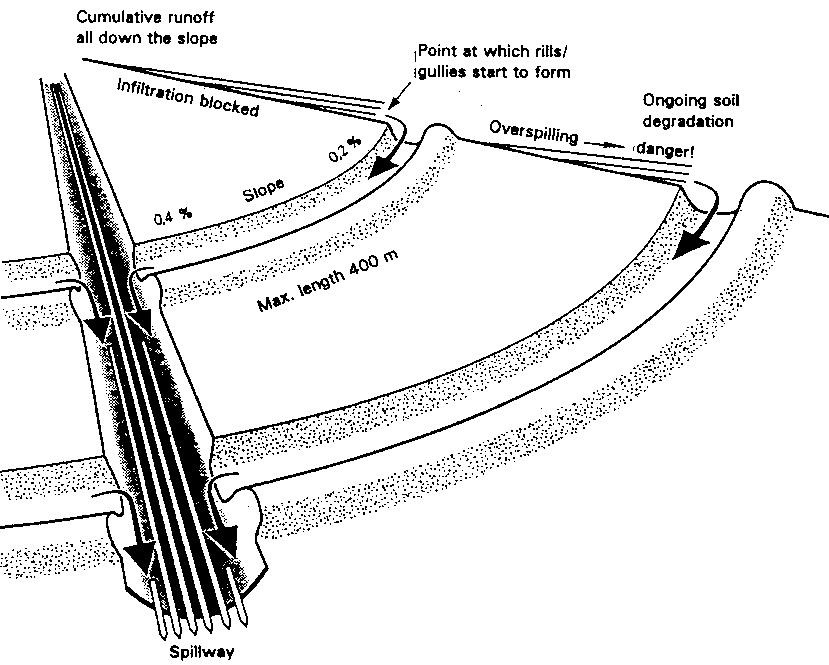
RUNOFF DIVERSION
When rainfall is too abundant or too intense to be stored or totally absorbed by the soil, it has to be drained via diversion ditches, bunds or terraces (Figure 45) in order to trap the sheet runoff before it gathers enough energy to gully the slope. Runoff is then evacuated from the cultivated area toward natural or manmade spillways to allow it to reach the low water point without causing too much damage.
Bennett developed this method of runoff management to counter the degradation of soils subject to mechanization in the Great Plains of the United States, but its application in developing countries is unfortunately fraught with problems.
Advantages. These ditches do drain excess water from cultivated areas.
Disadvantages. The ditches represent a loss of 5 to 15% in arable land.
Sheet erosion between the structures can persist, in which case soil will silt up the ditches (gentler slope), causing overflowing and gullying and ruining the whole installation. The structures require very precise surveying in order to allow the slope of the channels to increase gradually from 0.2 to 0.4%. They are expensive to build and maintain, requiring resources for rapid channel clearance and maintenance.
There are two kinds of gullying risk: on slopes when ditches overflow, and at spillways where water from a whole hillside is concentrated. This means that the problem has simply been shifted: there has been no reduction in soil degradation, nor in sheet erosion between the erosion control structures. In Africa, this system is rarely maintained as it should be, so that it generally ends in failure after four to ten years - and sometimes less - as ditches intended to evacuate runoff fill with eroded soil and subsequently overflow during the heaviest rainstorms.
FIGURE
45
Various runoff diversion
structures
Earth diversion bund
• effective, on slight slopes (1 to 8%);
• requires maintenance and stabilization with grass and shrubs:
• requires control of rodents and burrowing animals which find the soft earth good for tunnelling;
• not suitable for vertisols and other soils that crack in the dry season.
Figure A
Diversion ditch
• effective for draining steep slopes;
• sometimes permits irrigation of pasture through overspill and tying;
• increases the risk of landslides if it increases infiltration.
Figure B
Forest terrace
• suitable for reforestation in degraded mountain zones;
• allows plants to get a good start;
• requires simultaneous planting of an under-storey of booster plants (legumes, clover, Sylla).
Figure C
Algerian terrace
• introduces fruit trees which diversity production on farmland;
• loses 5 to 15% of land area;
• no Yield increases;
• 80%, failure on slopes > 40%;
• very often rejected by farmers because it hampers mechanized farming;
• land is sometimes abandoned because such structures are installed by State SPR departments (fear of expropriation by the State).
Figure D
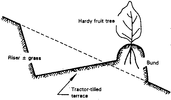
FIGURE 46 Runoff diversion: principles practice and drawbacks
Erosion depends on:
- rainfall energy (constant all down the slops)
- runoff energy (which increases with slope
Terraces:
- can evacuate accumulated runoff energy
- cannot reduce rainfall energy or soil degradation
DRAWBACKS
1. Need for expert surveying teams (high cost).
2. Considerable labour for installation and maintenance, hence generally:
• unprotected bunds
• channels clogged with sediment
• spillways neither grassed nor protected (dug too deep or silted up).
3. Loss of 5 to 15% of cultivated area with no increase in yields.
4. Loss of water and nutrients for fields downstream.
5. The structure will break down in a once-in-a-decade storm.
6. Varied widths of fields (making mechanization difficult).
7. Prevents neither sheet erosion nor degradation.
8. Serious risks of gullying if the bunds are broached (once in 4 to 10 yens).
9. Water concentrates more quickly. causing:
• high flood flows
• erosion of oxbows
• headward gullying
TABLE 34
Diversion bunds and an
intensive motorized system of preparing a shallow ferruginous
soil on gravel sheet have little effect on runoff, erosion and
yields of various crops: Gampela, 25 km from Ouagoudougou
(Burkina Faso) (cf. Roose and Piot 1984)
Plot area (about 0.5 ha) |
Runoff: KR % |
Erosion t/ha/yr |
Yields as % of control |
|
Max 24 h |
Kaar |
|||
Diversion bunds dh (difference in
level) = 40 cm + tillage + weeding hoeing |
31 |
4 |
1.4 |
|
tied |
||||
perpendicular to slope |
37 |
20 |
3.4 |
106 |
not tied |
||||
Idem but ridges parallel to slope,
not tied |
45 |
24 |
5.9 |
98 |
Traditional Mossi = non-tillage
Sod seeding in seed holes, then hoed twice |
43 |
23 |
4.1 |
100 |
Bare soil (standard USLE) (100
m²) |
70 |
40 |
16.0 |
- |
Table 34 shows how little effect diversion bunds have on runoff, erosion and yields for cultivation with intensive mechanized tillage on a shallow, tropical, ferruginous soil on gravel sheet (Roose and Piot 1984). On a broad pediment with a 0.7% slope, the CTFT compared runoff, erosion and yields on four plots between 1967 and 1972: a standard control plot, a traditional untilled Mossi field with sod-seeding in planting holes, and two plots with diversion bunds, using intensive methods of tillage, hoeing and ridging, parallel to the slope and untied on one, and perpendicular to the slope and tied in certain years on the other. The maximum runoff observed during the heaviest rainstorms on bare soil was 70%, while it varied from 37 to 45% on cropped soil, whatever cropping method was used, even falling to 31% when the ridges were tied.
Average annual runoff reaches 40% on bare plots. Plant cover reduces it to 20-24% whatever the cropping system, but only tied ridging brings a real reduction (4%). Erosion on these gentle slopes can be as much as 16 t/ha/yr on bare soil (but is cut to a quarter on cultivated soils), and a little higher on soils with ridging in the same direction as the slope (but significantly lower if the ridging is perpendicular to the slope and tied). However, there is no significant difference in yields under a traditional non-till system or under an elaborate system, with the use of numerous cropping techniques as well as diversion structures. On these shallow and fairly unproductive soils, there therefore seems no point in investing in either tillage or diversion ditches. Runoff reductions are slight, and even if they were sizeable, the soils are incapable of storing the water, so that the nutrients saved from runoff would quite probably be carried off in the drainage water.
Conclusions on diversion structures Following Bennett's manual and other work by American researchers, runoff diversion structures have been built all over the world in the past 50 years, with no prior tests of their effectiveness or suitability under local social and economic conditions. Today
it has become clear how ineffective they are in
Mediterranean areas, Sudano-Sahelian areas (Burkina Faso,
Niger) and the mountains of Central Africa, and on the
long pediments of South Africa. These methods are
expensive (especially the surveying work), reduce arable
land, and fail to prevent either loss of soil fertility
or sheet erosion. They are valid options only under
mechanized cropping systems, but are difficult to
maintain and should therefore be avoided in developing
countries. |
STRUCTURES TO DISSIPATE RUNOFF ENERGY
When rainfall exceeds the soil's absorption capacity, the sheet runoff can be controlled by spreading it across the whole slope rather than concentrating it in channels and outlets, where it can cause problems.
Its energy can be dispersed by keeping the speed below 25 cm/see - the speed corresponding to the energy needed for runoff to detach particles (Hjulström 1935) (Figure 20).
Such dispersion across the slope is achieved partly by cropping techniques that keep the soil surface rough (clods, many grass stalks, effect of weeds and mulching, etc.) and partly by structures such as permeable microdams, which temporarily slow the flow, allow some sedimentation, spread the flood, reduce peak flows and improve absorption.
Grass Strips (Table 35) reduced runoff to 30 or 60% of that on the control plot, and erosion to 30 and even 10%.
Hedges made up of two or three staggered lines of grasses or shrubs also operate as very effective permeable microdams.
On the Ruhande Experimental Station near Butare in Rwanda, König (1992) showed that on a 27% slope where erosion on bare soil can be as much as 550 t/ha/yr isolated trees have very little effect, whereas hedges of Calliandra or Leucaena planted every 10 metres cut erosion to less than 7 t/ha/yr Hedges of Setaria are twice as effective in reducing erosion (0.3 t/ha/yr but are exhausted after being used for forage for three to five years (Table 36).
On the ISAR Rubona Station, 20 km from Butare in Rwanda, Ndayizigiyé (1992) compared the erosion control effectiveness of shrub hedges of Calliandra, Calliandra plus Setaria, and Leucaena (two lines, 50 cm apart), placed 7 metres apart on a 24% slope on a very desaturated, sandy-clayey, ferralitic soil.
For rainfall of 1000-1250 mm (established over ten months), the average annual runoff coefficient (bare soil or traditional cropping) remains moderate (6 to 12%), but tends to increase as the soil surface degrades, and can exceed 45 to 50% with the heaviest rainstorms in the second rainy season on waterlogged soil. On the other hand, on plots protected by hedges, runoff tends to fall to under 2% whatever the type of plants, especially if prunings are spread on the soil surface between crops, and the weeds collected during hoeing are arranged at the foot of the hedges.