Watershed degradation and management
Back to contents - Previous file - Next file
In mountain and hill regions, land development is frequently and appropriately conducted in terms of watershed management planning. It is correspondingly possible to assess land degradation on a watershed basis, classifying watersheds on a range from non-degraded to severely degraded, as a basis for selecting priority areas for action. An estimate of this kind has been made, for example, for 100 watersheds in Nepal (FAO, 1988, p.9). Watershed degradation comprises elements of:
Data obtained from watershed surveys have been included in the above estimates of degradation. The watershed is a suitable basis for planning the control of land degradation in upland areas, particularly steeply sloping lands. Questions of watershed management are discussed in a number of reports for the Asian region (FAO, 1986a, 1988; FAO/RAPA, 1986; Doolette and Magrath, 1990; Magrath and Doolette, 1990; Castro, 1991).
Summary: the severity and extent of land degradation
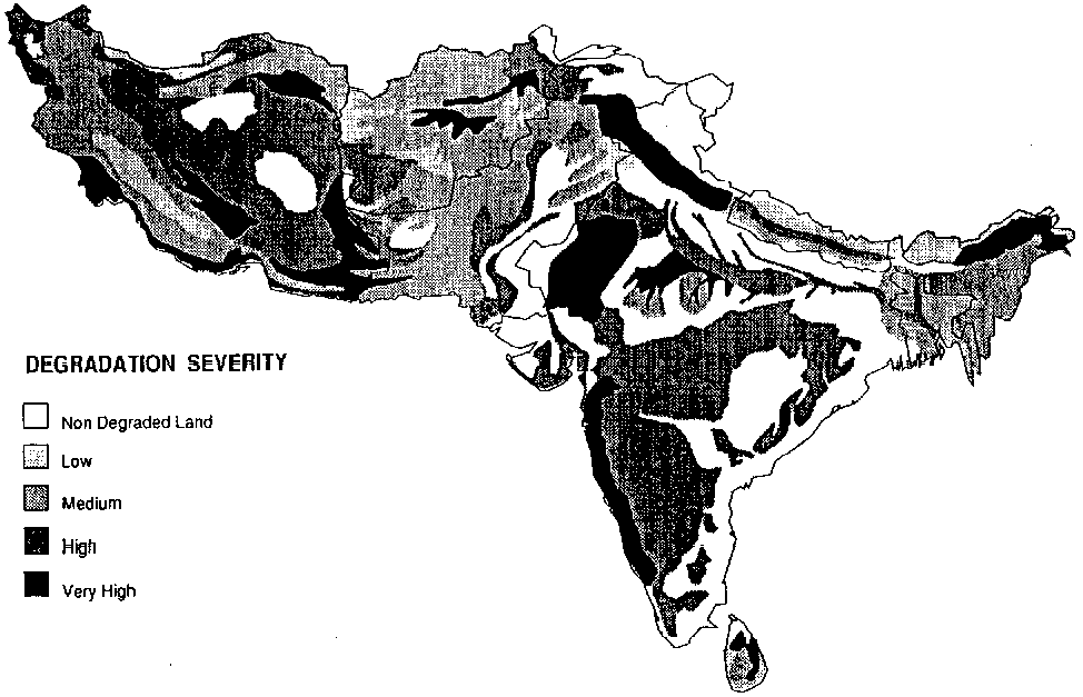
Table 17 and Figure 8 show total degradation according to the GLASOD data. This table and map exclude double counting, that is, areas affected by more than one kind of degradation are included only once in the totals. A total of 43% of the agricultural land of the region is assessed as affected by some type and degree of de gradation . A higher proportion of the dry zone is affected than the humid zone. Most areas of non-degraded land occur either in rainfed lands of the humid zone or irrigated alluvial areas of both zones. All countries except Bhutan are assessed as having over 25% of agricultural land degraded.
Figure 8 - Total degradation severity (GLASOD estimate}
TABLE 17 - GLASOD assessment: total areas by degree of degradation (Unit: 1000 ha)
| Light | Moderate | Strong | Total | Total
as percent of agricultural land |
|
| Afghanistan | 9 811 | 2 597 | 209 | 12 617 | 33% |
| Bangladesh | 6 187 | 1 080 | 0 | 7 267 | 75% |
| Bhutan | 36 | 0 | 4 | 40 | 10% |
| India | 2 935 | 20 128 | 21 941 | 45 005 | 25% |
| Iran | 17 721 | 29 574 | 8 301 | 55 596 | 94% |
| Nepal | 429 | 759 | 0 | 1 188 | 26% |
| Pakistan | 7 530 | 8 243 | 0 | 15 773 | 61 % |
| Sri Lanka | 35 | 158 | 838 | 1 030 | 44% |
| India, dry region | 1 176 | 3 083 | 10 899 | 15 158 | - |
| India, humid region | 1 759 | 17 045 | 11 042 | 29 846 | - |
| Dry zone | 36 238 | 43 497 | 19 409 | 99 144 | 66% |
| Humid zone | 9 338 | 19 042 | 11 883 | 40 263 | 24% |
| Region | 45 576 | 62 538 | 31 293 | 139 408 | 43% |
Note: For areas with more than one type of degradation the most severe type is used for summation.
Table 18 and 19 show the best estimates from the present study, based initially upon GLASOD data but modified for certain types of degradation and particular countries as given above. The totals include 'double counting', i.e. areas affected by more than one type of degradation. Water erosion is the most widespread form of degradation, affecting both humid and dry zones. Nearly 40% of the dry zone is affected by wind erosion. Soil fertility decline is certainly widespread, but its extent is not know quantitatively; the values shown are tentative estimates, and may be longer or higher. Waterlogging, salinization and lowering of the water table are of smaller total extent, but their effect is proportionally more serious in that they affect mainly irrigated lands, which when undegraded have high productive potential.
Areas with the most severe and extensive land degradation include:
These are among the priority areas for action to prevent further degradation. In addition, however, evidence suggests that the problem of soil fertility decline is more widespread, at least to the degree defined as light, and is of increasing severity; besides the large areas of Bangladesh and Sri Lanka given by the GLASOD survey, the problem affects substantial areas of both India and Pakistan.
TABLE 18 - Best estimates of areas affected by land degradation (Unit: 1000 ha)
| Light | Moderate | Strong | Total | Total
as percent of agricultural land |
|
| WATER EROSION | |||||
| Afghanistan | 8.6 | 2.6 | 0.0 | 11.2 | 29% |
| Bangladesh | 0.0 | 1.5 | 0.0 | 1.5 | 15% |
| Bhutan | <0.1 | 0.0 | <0.1 | <0.1 | 10% |
| India* | 2.9 | 17.2 | 12.6 | 32.8 | 18% |
| Iran | 14.5 | 11.9 | 0.0 | 26.4 | 45% |
| Nepal | 0.5 | 1.1 | 0.0 | 1.6 | 34% |
| Pakistan | 6.1 | 1.1 | 0.0 | 7.2 | 28% |
| Sri Lanka | 0.1 | 0.2 | 0.8 | 1.1 | 46% |
| India, dry region | 1.2 | 0.0 | 1.7 | 2.9 | - |
| India, humid region | 1.8 | 17.2 | 10.9 | 29.9 | - |
| Region | 32.7 | 35.6 | 13.5 | 81.7 | 25% |
| WIND EROSION | |||||
| Afghanistan | 1.9 | 0.0 | 0.2 | 2.1 | 5% |
| Bangladesh | 0.0 | 0.0 | 0.0 | 0.0 | 0% |
| Bhutan | 0.0 | 0.0 | 0.0 | 0.0 | 0% |
| India | 0.0 | 1.8 | 9.0 | 10.8 | 6% |
| Iran | 6.6 | 25.7 | 3.1 | 35.4 | 60% |
| Nepal | 0.0 | 0.0 | 0.0 | 0.0 | 0% |
| Pakistan | 4.0 | 6.7 | 0.0 | 10.7 | 42% |
| Sri Lanka | 0.0 | 0.0 | 0.0 | 0.0 | 0% |
| India, dry region | 0.0 | 1.8 | 9.0 | 10.8 | - |
| India, humid region | 0.0 | 0.0 | 0.0 | 0.0 | - |
| Dry zone | 12.4 | 34.2 | 12.3 | 59.0 | 39% |
| Humid zone | 0.0 | 0.0 | 0.0 | 0.0 | 0% |
| Region | 12.4 | 34.2 | 12.3 | 59.0 | 18% |
| SOIL FERTILITY DECLINE | |||||
| Afghanistan | 0.0 | 0.0 | 0.0 | 0.0 | 0% |
| Bangladesh | 6.4 | 0.0 | 0.0 | 6.4 | 65% |
| Bhutan | 0.0 | 0.0 | 0.0 | 0.0 | 0% |
| India | 26.2 | 0.0 | 3.2 | 29.4 | 16% |
| Iran | 0.0 | 0.0 | 0.0 | 0.0 | 0% |
| Nepal | 0.0 | 0.0 | 0.0 | 0.0 | 0% |
| Pakistan | 5.2 | 0.0 | 0.0 | 5.2 | 20% |
| Sri Lanka | 0.7 | 0.7 | 0.0 | 1.4 | 61 % |
| India. dry region | 2.2 | 0.0 | 0.0 | 2.2 | - |
| India. humid region | 24.0 | 0.0 | 3.2 | 27.2 | - |
| Dry zone | 7.4 | 0.0 | 0.0 | 7.4 | 5% |
| Humid zone | 31.1 | 0.7 | 3.2 | 35.0 | 20% |
| Region | 38.5 | 0.7 | 3.2 | 42.4 | 13% |
| WATERLOGGING | |||||
| Afghanistan | 0.0 | 0.0 | 0.0 | 0.0 | 0% |
| Bangladesh | 0.0 | 0.0 | 0.0 | 0.0 | 0% |
| Bhutan | 0.0 | 0.0 | 0.0 | 0.0 | 0% |
| India | 0.0 | 3.1 | 0.0 | 3.1 | 2% |
| Iran | 0.5 | 0.0 | 0.0 | 0.5 | 1% |
| Nepal | 0.0 | 0.0 | 0.0 | 0.0 | 0% |
| Pakistan | 0.8 | 0.4 | 0.8 | 2.0 | 8% |
| Sri Lanka | 0.0 | 0.0 | 0.0 | 0.0 | 0% |
| India, dry region | 0.0 | 3.1 | 0.0 | 3.1 | - |
| India, humid region | 0.0 | 0.0 | 0.0 | 0.0 | - |
| Dry zone | 1.4 | 3.5 | 0.8 | 5.7 | 4% |
| Humid zone | 0.0 | 0.0 | 0.0 | 0.0 | 0% |
| Region | 1.4 | 3.5 | 0.8 | 5.7 | 2% |
| SALINIZATION | |||||
| Afghanistan | 1.3 | 0.0 | 0.0 | 1.3 | 3% |
| Bangladesh | 0.0 | 0.0 | 0.0 | 0.0 | 0% |
| Bhutan | 0.0 | 0.0 | 0.0 | 0.0 | 0% |
| India | 0.0 | 3.5 | 3.5 | 7.0 | 4% |
| Iran | 5.0 | 7.0 | 4.0 | 16.0 | 27% |
| Nepal | 0.0 | 0.0 | 0.0 | 0.0 | 0% |
| Pakistan | 1.9 | 1.0 | 1.3 | 4.2 | 16% |
| Sri Lanka | <0.1 | 0.0 | 0.0 | <0.1 | 2% |
| India, dry region | 0.0 | 3.5 | 3.5 | 7.0 | - |
| India, humid region | 0.0 | 0.0 | 0.3 | 0.3 | - |
| Dry zone | 8.2 | 11.5 | 8.5 | 28.1 | 19% |
| Humid zone | <0.1 | <0.1 | 0.3 | 0.4 | <1% |
| Region | 8.2 | 11.5 | 38.8 | 28.5 | 9% |
| LOWERING OF THE WATER TABLE | |||||
| Afghanistan | 0.0 | 0.0 | 0.0 | 0.0 | 0% |
| Bangladesh | 0.0 | 0.0 | 0.0 | 0.0 | 0% |
| Bhutan | 0.0 | 0.0 | 0.0 | 0.0 | 0% |
| India | 0.1 | 0.1 | 0.0 | 0.2 | < 1% |
| Iran | 12.1 | 7.4 | 0.0 | 19.5 | 33% |
| Nepal | 0.0 | 0.0 | 0.0 | 0.0 | 0% |
| Pakistan | 0.0 | 0.1 | 0.0 | 0.1 | <1% |
| Sri Lanka | 0.0 | 0.0 | 0.0 | 0.0 | 0% |
| India, dry region | 0.1 | 0.1 | 0.0 | 0.2 | - |
| India, humid region | 0.0 | 0.0 | 0.0 | 0.0 | - |
| Dry zone | 12.2 | 7.7 | 0.0 | 19.8 | 13% |
| Humid zone | 0.0 | 0.0 | 0.0 | 0.0 | 0% |
| Region | 12.2 | 7.7 | 0.0 | 19.8 | 6% |
Values of water erosion for India may be substantially higher.
TABLE 19 - Percentages of agricultural land affected by degradation: summary
Percent of agricultural land affected |
|||
| Type of land degradation | Dry zone |
Humid zone |
Region |
| Water erosion | 32 |
20 |
25 |
| Wind erosion | 39 |
0 |
18 |
| Soil fertility decline | 5 |
20 |
13 |
| Waterlogging | 4 |
0 |
2 |
| Salinization | 19 |
< 1 |
9 |
| Lowering of the water table | 13 |
0 |
6 |
The wide range of estimates for the nature and extent of many types of land degradation has been repeatedly noted. Estimates frequently differ by as much as 100%, in some cases more. Reasons for this variation are:
Two recommendations arise from this. First, further efforts should be made to define degrees of severity of land degradation; these should be in terms that permit objective surveys and monitoring. Secondly, field surveys of existing soil degradation and, most importantly, monitoring of soil changes, should be conducted, in order to improve the state of knowledge.
This overall situation raises an important question: should greater efforts, including investment, immediately be made to combat land degradation, or should these await the acquisition of better data? A 'contrary' view exists, which may be expressed as follows:
"Estimates of the extent of land degradation, and/or of their effects on production, may be considerably exaggerated. They may have been magnified by sectional interests in conservation, or by governments. Because the data are so uncertain, we do not know whether degradation is as serious as it is claimed to tee. Unless and until there is a better foundation of evidence, we cannot justify the expenditure of scarce development funds on measures to combat degradation."
This view serves one important purpose, in that it places emphasis on what are, indeed, large uncertainties in estimates of the extent of degradation and its effects.
Whilst it is certainly true that some of the estimates are based on questionable foundations, this view is rejected. Reports from all countries of the region (supported for sample areas by the authors of this study) point to the certain existence of two types of situation:
It is therefore concluded that, although more precise data should be obtained, the total evidence is sufficient to call for immediate action to prevent further land degradation and, where still possible, to reverse the effects of past degradation.