![]()
![]()
![]()
Situated in the northwest corner of India. Gujarat is the seventh largest State in India and comprises three distinct geographic regions, viz., the undulating terrains of Saurashtra, which is a peninsula jutting into the Arabian sea, the Rann (desert) of Kachchh in the north, bordering Pakistan, and the mainland which is essentially the alluvial plains. The latter are drained by the big rivers Sabarmati. Mahi, Narmada and Tapti, and by the smaller rivers Banas, Saraswati and Damanganga. Northern districts are arid with scanty rainfall. In the rest of the State, rainfall varies between 65 to 127 cm. With the tropic of Cancer passing through it. Gujarat has a hot and cold climate. But, the nearness to Arabian sea and the Gulf of Cambay in the West and the forest covered hills in the east moderate the climatic extremes.
All major rivers in Gujarat are west-flowing. The Sabarmati has a catchment of 21 674 km2, 81% of which lies in Gujarat. Similarly 34% of the Mahi basin and 11.5% of the Narmada basin lie in the State, mainstreams of all the three meeting the Arabian sea. A large number of minor streams radiate down from the hills of Saurashtra joining the Arabian sea, Gulf of Kachchh and the Gulf of Khambhat. This network of small rivers and undulating terrain creates ideal conditions for water resource development projects and thus the five districts of Saurashtra, viz., Rajkot, Jamnagar, Junagarh, Amreli and Bhavanagar among themselves share nearly half of the reservoirs in the State (Fig. 9.1). Sabarkantha, Panchmahals and Surat also have large areas under man-made lakes.
The State Fisheries Department of Gujarat has listed 50 reservoirs, covering an area of 242 205 ha. This is in addition to 561 small irrigation tanks, which are actually reservoirs, with a waterspread of 44 025 ha. Thus, the total area under reservoirs in the State is 286 230 ha. More than 95% (in number) of these man-made lakes belong to the small category, although they form only 29% of the total area (Table 9.1). The small reservoirs in the State have an average size of 349 ha. There is a large concentration of these small water bodies (< 1 000 ha) in the western half of the State, mainly the Saurashtra. The Kachchh district and the Saurashtra region together have 85 small reservoirs, out of the total 115 in the State. The medium reservoirs (1 000–5 000 ha) are spread over 12 districts (average size 2 000 ha). Rajkot district with 8 and Sabarkantha with 5 have the maximum concentration (Table 9.2). The seven large reservoirs (>5000 ha) in the State, viz., Dharoi (Mehsana district), Kadana, Panam (Panchmahal district), Kakarapur, Vallabhsagar (Surat district), Damanganga (Valsad district) and Shetrunji (Bhavanagar district) have a total area of 144 358 ha and an average size of 20 622 ha. Among them, Dharoi, Kadana, Kakarapur and Ukai are in the above– 10 000 ha class (Table 9.3).
Very few scientific investigations have been conducted on the reservoirs of Gujarat. The Central Inland Fisheries Research Institute conducted ecological studies on Ukai during the 1970s, as a part of the All India Coordinated Research Project on Reservoir Fisheries. Some information is also available on Sayaji Sarovar in Vadodara.
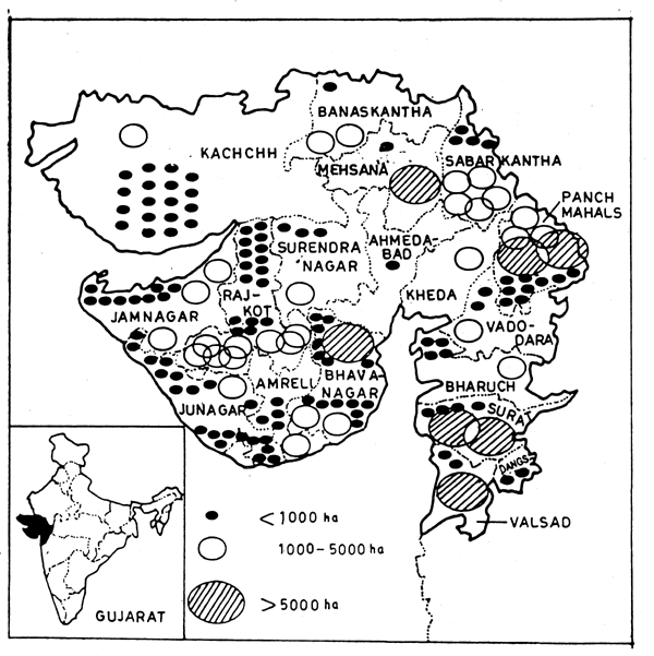
Figure 9.1. Distribution of reservoirs in Gujarat
| District | Small (≤1 000 ha) | Medium (1 000–5 000 ha) | Large (≥5 000 ha) | Total | ||||
|---|---|---|---|---|---|---|---|---|
| No. | Area (ha) | No. | Area (ha) | No. | Area (ha) | No. | Area (ha) | |
| Ahmedabad | 1 | 296 | - | - | - | - | 1 | 296 |
| Banaskantha | 1 | 578 | 2 | 6615 | - | - | 3 | 7 193 |
| Bharuch | 4 | 634 | 1 | 3 677 | - | - | 5 | 4 311 |
| Kheda | - | - | 1 | 2 086 | - | - | 1 | 2 086 |
| Mehsana | 1 | 277 | - | - | 1 | 10 700 | 2 | 10 977 |
| Panchmahals | 9 | 4 915 | 1 | 1 668 | 2 | 25 580 | 12 | 32 163 |
| Sabarkantha | 4 | 936 | 5 | 11 850 | - | - | 9 | 12 786 |
| Surat | 4 | 869 | - | - | 2 | 96 200 | 6 | 97 069 |
| Vadodara | 2 | 697 | 1 | 2 904 | - | - | 3 | 3 601 |
| Valsad | 2 | 674 | - | - | 1 | 5 144 | 3 | 5 818 |
| Dang | 2 | 17 | - | - | - | - | 2 | 17 |
| Amreli | 4 | 1 862 | 1 | 3 285 | - | - | 5 | 5 147 |
| Bhavanagar | 14 | 5 810 | 2 | 2 207 | 1 | 67 34 | 17 | 14 751 |
| Jamnagar | 10 | 2 989 | 3 | 5 018 | - | - | 13 | 8 007 |
| Junagarh | 20 | 5 802 | 1 | 1 581 | - | - | 21 | 7 383 |
| Rajkot | 16 | 5 166 | 8 | 13 798 | - | - | 24 | 18 964 |
| Surendranagar | 3 | 1 963 | 1 | 1 914 | - | - | 4 | 3 877 |
| Kachchh | 18 | 6 614 | 1 | 1 145 | - | - | 19 | 7 759 |
| Total | 115 | 40 099 | 28 | 57 748 | 7 | 144 358 | 150 | 242 205 |
| Irrigation tanks | 561 | 44 025 | - | - | - | - | 561 | 44 025 |
| Grand Total | 676 | 84 124 | 28 | 57 748 | 7 | 144 358 | 711 | 286 230 |
Compiled from the information provided by the Department of Fisheries, Gujarat
| Reservoir | District | Area at FRL (ha) |
|---|---|---|
| Dharoi | Mehsana | 10 700 |
| Kadana | Panchmahals | 16 600 |
| Panam | " | 8 980 |
| Kakarapur | Surat | 44 200 |
| Vallabhsagar | " | 52 000 |
| Damanganga | Valsad | 5 144 |
| Shetrunji | Bhavanagar | 6 734 |
| RESERVOIR | DISTRICT | AREA AT FRL (ha) |
|---|---|---|
| Datiwada | Banaskantha | 4 047 |
| Sipu | " | 2 568 |
| Karjan | " | 3 677 |
| Vanakobori | Kheda | 2 086 |
| Deo | Panchmahals | 1 668 |
| Hathmati | Sabarkantha | 3 236 |
| Meshwo | " | 1 116 |
| Watrak | " | 4 475 |
| Guhai | " | 1 713 |
| Mazam | " | 1 310 |
| Sukhi | Vadodara | 2 904 |
| Sankroli | Amreli | 3 285 |
| Ranghola | Bhavanagar | 1 162 |
| Sukhbhandar | " | 1 045 |
| Sasoi | Jamnagar | 1 468 |
| Uni | " | 1 730 |
| Sani | " | 1820 |
| Amipur | Junagarh | 1 581 |
| Bhandar | Rajkot | 4 400 |
| Moj | " | 1 203 |
| Phophal | " | 1 207 |
| Machhu I | " | 1 200 |
| Machhu II | " | 1 396 |
| Aji II | " | 1 439 |
| Demi II | " | 1 023 |
| Nyari I | " | 1 930 |
| Brahmi | Surendranagar | 1 914 |
| Tapar | Kachchh | 1 145 |
| Total | 57 748 |
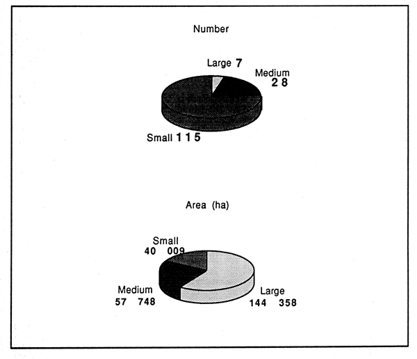
Figure 9.2. Areas under different categories of reservoirs in Gujarat
Ukai also known as Vallabhsagar, is the largest reservoir in Gujarat situated on the river Tapti at 21° 15'N and 73° 35'E. Completed in 1971, this multi-purpose reservoir has a catchment of 62 255 km2 and a waterspread of 52 000 ha at FRL of 105.10 ma above MSL with a mean depth of 11.8 m. Vallabhsagar has a moderately irregular shoreline 9shoreline development index 5.56). The water level fluctuates up to 23 m during different seasons. Information furnished in the following account has been obtained from carious resports of the Central Inland Fisheries Research Institute, Barrackpore (Anon., 1980, 1983, 1984b).
The prevailing climatic conditions have a key role in determining the thermal and nutrient regime of the reservoir. The local precipitation is high, e.g., during 1983–84 it was 156 cm. Ukal witnesses climatic extremes with the air temperature going above 45°C (47.6°C in May 1983) during summer and the minimum of 6.0°C during winter months.
The water is rich in nutrients and dissolved salts, both from the allochthonous enrichments and due to the flooded fertile soil. The catchment area comprises forest land, which received precipitation of79 cm. Apart from the cumulative addition from the inflowing waters, the per se nutrient status of the reservoir bottom is equally high, as 99% of the submerged area is either agricultural (58%) or forest (41%) land. The organic carbon in the flooded soil is high (0.31– 3.6%). with matching available phosphorus (1.2 – 2.0 mg 100 g-1) and nitrogen (12.00 – 32.48 mg 100 g-1). The soil is alkaline in reaction (pH: 7.3–7.9).
Productive potential is also well-reflected in all measurable physico-chemical attributes of water quality (Table 9.4). The pH is uniformly high without deviating much from the mean of 8.3. Transparency, exhibiting a strong seasonality, ranges between 8.5 to 328 cm. The values of bicarbonates and the specific condutivity in consonance with the ions of magnesium and calcium indicate high production potential of the water. Nitrate nitrogen and phosphate phosphorus levels are very high, despite the absence of any anthropogenic sources of organic enrichment. Thus, the reservoir maintains its high productivity due to the allochthonous and intrinsic nutrient loading.
| Parameters | Range in variation (n=24 | Mean±SD |
|---|---|---|
| Water temperature (°C) | 20.0–32.6 | 26.5±3.89 |
| Transparency (cm) | 8.5–328.0 | 102.4±83.98 |
| pH | 8.0–8.4 | 8.3±8.3±0.13 |
| Dissolved oxygen (mg 1-1) | 3.7–14.0 | 8.3±2.97 |
| Carbon dioxide (mg 1-1) | nil–20.1 | *9.5±5.81 |
| CO3 (mg 1-1) | 0.2–30.0 | 9.6±7.53 |
| HCO3 (mg 1-1) | 98.0–366.0 | 166.0±65.01 |
| Sp. conductivity (μ mhos) | 41.0–585.0 | 322.3±191.91 |
| Ca++ (mg 1-1) | 12.0–58.0 | 29.6±10.64 |
| Mg++ (mg 1-1) | 6.7–33.8 | 13.6±7.72 |
| No3N (mg 1-1) | 0.02–0.09 | 0.050±0.02 |
| PO4P (mg 1-1) | 0.012–1.00 | 0.110± |
| Silicates (mg 1-1) | 0.06–0.82 | 0.093- |
| Dissolved organic matter (mg 1-1) | 0.02–28.0 | 11.85±6.60 |
* Mean of eight values only (Anon., 1980)
The sharp difference between the air temperatures of summer and winter seasons notwithstanding, thermal stratification does not occur during summer due to the continuous water uptake. Even during the peak of the dry season of April-May, when the inflow trickles down to 0.63 to 3.45 million m3 (compared to the heavy influx of 5 320 million m3 during September), a steady outflow of 142 to 176 million m3 of water is maintained for various purposes. Thus, instable conditions prevail in the reservoir resulting in a vertical mixing of water.
The tropholytic zone is characterised by the decline in oxygen (7.2 mg 1-1 at the surface to 5.6 mg 1-1 at 16 m). Dissolution of carbonates as bicarbonates in the presence of CO2 is evidenced by the increase in bicarbonates towards the bottom (150 mg 1-1 at the surface to 168 mg 1-1 at 12 m depth). This vertical stratification of chemical parameters indicates high rate of organic productivity.
The gross primary productivity rate during 1977–78 to 1982–83 ranged from 70.92 and 661.44 mg C m-3 day -1 (mean 218.42 ± 122.5). The plankton community of the reservoir is exceptionally rich, the volumetric abundance ranging from 0.3 to 35.5 ml m-3 (Table 9.5).
| Year | Volumetric abundance of plankton (ml m-3) |
|---|---|
| 1976–77 | 5.26 to 6.60 |
| 1977–78 | 12.5 to 22.5 |
| 1978–79 | 2.0 to 35.5 |
| 1979–80 | 1.0 to 6.3 |
| 1980–81 | 0.95 to 11.0 |
| 1981–82 | 0.3 to 6.7 |
| 1982–83 | 0.23 to 12.6 |
The organically rich bottom is favourable for the rapid growth of benthic macrofauna, although the sharp fluctuations in water level are an inhibiting factor. Among the benthic animals, gastropods, which have some ability to adjust with the receding and rising water levels, form the most dominant group. The lentic zone of the lake promotes a better growth of benthic community, than the lotic. Population density of gastropods in the lentic sector during the seven years from 1976–77 varied from 93 to 474 individuals m-2 with a mean of 225. Mean density of all benthic organism for the same period is 453,300 and 178 individuals m-2 for the lentic, intermediate and lotic sectors (Table 9.6).
The indigenous ichthyofauna of the river Tapti before impoundment, comprised mainly the Indian hilsa, Tenualosa ilisha, Tor tor, Aorichthys seenghala, A. aor, Labeo fimbriatus, and Wallago attu (Menon, 1973). The hilsa has a smoth passage from the Arabian sea up to the Ukai dam through the Tapti estuary, though the migratory pathway is threatened to be obstructed by the proposed Navagam dam across the Tapti.
Soon after the impoundment, the fish stock in the reservoir became thinner and stocking was resorted to with Indian major carps for building commercial fish populations which proved to be very useful. The stocked major carps have established themselves firmly and have commenced breeding in the reservoir, contributing to autostocking. The young ones of Indian major carps which escape from the dam through the outlets have helped the stocking of downstream impoundments. The fish catch structure in the main river Tapti, 112 km downstream, has changed in favour of the Indian major carps, by virtue of the stock augmentation from the outflowing waters of Vallabhsagar reservoir.
| 1976–77 | 77–78 | 78–79 | 79–80 | 80–81 | 81–82 | 82–83 | Mean | |
|---|---|---|---|---|---|---|---|---|
| LENTIC SECTOR | ||||||||
| Gastropods | 474 | 189 | - | 237 | 93 | 136 | 221 | 225 |
| Bivalves | 47 | 164 | - | 50 | 71 | 68 | 54 | 76 |
| Oligochaetes | 13 | 49 | - | 20 | 2 | 1 | 826 | 152 |
| LENTIC TOTAL | 534 | 402 | - | 307 | 166 | 205 | 1 101 | 453 |
| INTERMEDIATE | ||||||||
| Gastropods | 292 | 291 | 266 | 185 | 99 | 110 | 100 | 192 |
| Bivalves | 38 | 20 | 157 | 89 | 37 | 52 | 38 | 61 |
| Oligochaetes | - | - | - | 9 | 2 | 2 | 318 | 47 |
| INTERMEDIATE TOTAL | 330 | 311 | 423 | 283 | 138 | 164 | 456 | 300 |
| LOTIC SECTOR | ||||||||
| Gastropods | 199 | 92 | 180 | 133 | 77 | 68 | 99 | 120 |
| Bivalves | 38 | 48 | 50 | 41 | 32 | - | 19 | 33 |
| Oligochaetes | 158 | 20 | - | - | - | -1 | - | 25 |
| LOTIC TOTAL | 395 | 160 | 230 | 174 | 109 | 69 | 118 | 178 |
| MEAN FOR THE YEAR | 420 | 291 | 326 | 255 | 134 | 146 | 558 | 310 |
Stocking of the reservoir was initiated in 1972, when it was still informative stage. After the initial stocking, fishing was not allowed for three years to facilitate building-up of a stock of carps. During the period between 1972 and 1977, more than 5 million fry/fingerlings (30–150 mm) of catla (40.9%), rohu (29.0%) and mrigal (30.1%) were stocked into the reservoir, along with 1 600 of their brooders. In the subsequent years, the stocking rate was erratic, varying between 65 000 to 3 million (Table 9.7). The species composition of 4:3:3 for catla, rohu and mrigal was more or less followed over the years.
Attempts were made to build up a stock of hilsa (Tenualosa ilisha) in the reservoir through stocking. In the year 1979, hilsa eggs fertilised through artificial fecundation were reared into fry in enclosures installed in the reservoir and 5 000 fry were released into the reservoir. Nevertheless, the fish failed to appear in the commercial catches.
| Year | No.stocked (in thousands) |
|---|---|
| 1975–76 | 1 514 |
| 1976–77 | 494 |
| 1977–78 | 1 044 |
| 1978–79 | 65 |
| 1979–80 | 635 |
| 1980–81 | 329 |
| 1981–82 | 272 |
| 1982–83 | - |
| 1983–84 | 200 |
| 1984–85 | 439 |
| 1985–86 | 3 000 |
| 1986–87 | 1 836 |
| 1987–88 | 2 877 |
| 1988–89 | 3 000 |
The success of stocking carps in the reservoir is phenomenal. The bountiful fish food resources in the form of plankton and rich bottom detritus have proved to be a boon for the major carps, Catla catla, Labeo rohita, and Cirrhinus mrigala and the indigenous Tor tor. Apart from contributing 80 to 85% to the total catch, they represented higher year classes. Average size of catla was 5.7 kg. 5.1 kg. 3.0 kg. and 4.2 kg during 1977–78, 1978–79, 1979–80 and 1980–81. Similarly, the size range of L. rohita and C. mrigala were within 1.5 and 2.66 kg during the same period. The size of T. tor in the catches varied from 1.87 kg to 2.83 kg. This suggests that the fish stocks can sustain a good fishery even at a higher level of fishing effort, without risking over-exploitation.
Fisheries
Based on the figures available at the cooperative societies, the fish production from the reservoir ranged from 138 to 240 t during the period 1975–76 to 1979–80 (Table 9.8). This is only a fraction of the actual catch. Large quantity of fish is sent to various destinations bypassing the cooperative societies.
Fishing licences are issued to fishermen on a royalty basis. They pay to the Government Rs. 1 per kg of major carps and Rs. 0.50 per kg of other fishes they catch from the reservoir. A similar amount is charged by the cooperative society to cover their managerial expenses. The royalty charged by the Government is spent on the reservoir management. Banks provide financial assistance to the fishermen for procurement of nylon nets. Nevertheless, a large number of fishermen resort to illegal fishing and sell their catch to private merchants who abet this clandestine operation. Government often finds it difficult to curb this practice due to inadequate supervisor manpower and other logistic problems. At present, 4 069 tribal men are registered under the 12 cooperative societies as fishermen, while about 5 000 others are believed to be operating in the reservoir illegally.
Only a fraction of the catch is channelled through the cooperatives. According to one of the revealing estimates, the fish despatched to the Calcutta market from the railway station during 1975–76 to 1976–77 was 4 000 t, against the official reservoir catch statistics of 444 t. The State Fisheries Department has resorted to sample surveys for a more realistic estimation of catch since 1983–84. Information collected from the railway records, and other sources has also been utilised for this purpose. According to this estimate, the production ranged from 863 to 3 989 t (Table 9.9) and the yield rate touched 109 kg ha-1 during 1988–89. The steady increase in production since 1986–87 is attributed to the improved stocking (Tripathy, 1990). Vallabhsagar, is one of most productive reservoirs in the country.
| 1975–76 | 1976–77 | 1977–78 | 1978–79 | 1979–80 | |
|---|---|---|---|---|---|
| Total catch (t) | 240.0 | 204.3 | 149 | 204 | 138 |
| Catla catla(%) | 16.55 | 20.55 | 33.70 | 38.80 | 22.05 |
| L. rohita(%) | 51.85 | 36.00 | 30.60 | 27.20 | 24.05 |
| C. mrigala(%) | 13.25 | 14.85 | 14.67 | 13.50 | 17.20 |
| Tor tor(%) | 6.55 | 7.90 | 6.01 | 5.05 | 19.06 |
| Misc.(%) | 11.80 | 20.70 | 15.02 | 15.45 | 17.64 |
| Year | Estimated production (t) | Yield rate (kg ha-1) |
|---|---|---|
| 1983–84 | 863 | 23.6 |
| 1984–85 | 1 159 | 31.7 |
| 1985–86 | 1 610 | 44.1 |
| 1986–87 | 2 023 | 55.4 |
| 1987–88 | 2 869 | 78.5 |
| 1988–89 | 3 989 | 109.2 |
Displaced tribals
Vallabhsagar reservoir inundated 170 villages, affecting more than 16 000 families, 90% them belonging to the tribals. All the affected were rehabilitated in 17 clusters of villages on the periphery of the reservoir (Mod et al.,1985). Fisheries has been considered as one of the means to rehabilitate the people who lost their source of livelihood on account of displacement. In the year 1975, when the commercial fishing was initiated in the reservoir, the tribal men were organised into fishermen's cooperative societies, under a tribal development scheme. Apart from distributing boats and nets to the members on a 50% subsidy basis, they were also trained in handling various fishing craft and gear. So far, 800 youths have been trained by the Government. At present, 1 200 fishing boats operate in the reservoir, employing thousands of units of gill nets.
The fact that there is so much interest in entering into fisheries is a testimony to the high remunerativeness of the fishing operations. The successful establishment of the carp populations facilitates the high fish production. The reservoir perhaps holds even a higher potential than what it produces today. The present annual fish landings of nearly 4000 t (1988–89) are only half the production potential of 8 000 t, as estimated by the Central Inland Fisheries Research Institute, based on the primary production rates.
Construction of roads for quick transportation of catch and effective measures to keep the middlemen and unscrupulous merchants at bay are prerequisites for bringing the fisheries operations into the legal fold.
Located at 23°30' N. 24 km distant from Vadodara, Sayajisarovar is a small reservoir covering 145 ha. Despite a low mean depth (3.4 m) and high shore development index (10.19) the reservoir does not show eutrophic tendencies (Ganapati and Pathak, 1969). Exposed to wind action, complete turnover takes place by 0600 hrs every day. Nitrogenous and phosphatic nutrients are in traces and silicate is in very low concentration (0.03 to 0.5 mg 1-1). Plankton population is scanty and photosynthesis is chiefly through the macrophytes, Vallisneria spiralis and Potamogeton natans, which absorb most of the nutrients. Phytoplankton, forming only 5% of the total plankton count, is represented chiefly by Pediastrum simple and, Botryoccocus braunii. Eutrophic species are conspicuous by their absence. Photosynthetic production of oxygen (gross) as estimated by Ganapati and Pathak (1969) was 0.42 to 7.64 g m-2 day-1 in 1963 and 0.45 to 1.57 g m-2 day -1 during 1964. The annual average photosynthetic efficiency during the two years was 0.63% and 1.18% respectively.
Gujarat is an important State from the fisheries point of view. At present, the main emphasis is on marine fisheries. With the longest coastline among the mainland States of India, Gujarat has a flourishing marine fisheries. Against the current (1992–93) marine fish production of 0.61 million t, the inland water bodies produce 51 154 t, or 7.7% of the total fish landings. The State has registered more than 3.5 times increase in inland fish production during the last two decades. During 1971–72, the total production was 14 167 t which increased to 19 323 t in 1981–82 and 51 154 t in 1992–93.
Per capita consumption of fish in Gujarat is one of the lowest in India. In rural and urban areas, the monthly consumption is 0.02 kg, against 1.06 kg (rural) and 1.59 kg (urban) of Kerala. The State needs quantum jumps in fish production in order to increase the availability of fish to its people. The reservoir fish production can assist in achieving this objective.
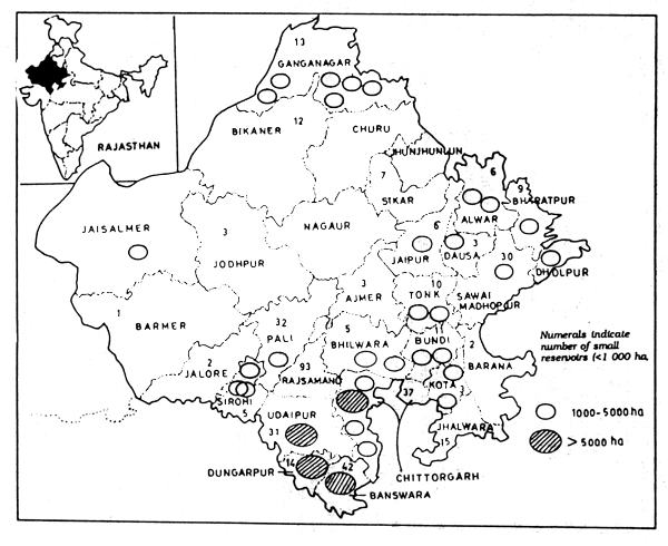
Figure 10.1. Distribution of reservoirs in Rajasthan
![]()
![]()
![]()