![]()
![]()
![]()
| Path/row | Sensor | Date | |
| Recent image | 135/42 | TM | 05 February 1988 |
| Historical image | 145/42 | MSS | 06 December 1981 |
| State assessment results based on the interpretation of the entire recent image | ||||||
| Main Classes | Additional classes | |||||
| '000ha | % | '000 ha | % | |||
| Closed Forest | 1230.4 | 40.3 | c.c.>70 % | |||
| c.c.40 – 70% | ||||||
| Open Forest | 45.2 | 1.5 | ||||
| Long Fallow | 783.2 | 25.7 | ||||
| Fragm.Forest | 189.2 | 6.2 | Forest fraction 40–70% | 189.2 | 6.2 | |
| Forest fraction 10–40% | 0.0 | 0.0 | ||||
| Shrubs | 50.4 | 1.7 | Dense (c.c.>40%) | |||
| Sparse (c.c. 10–40%) | ||||||
| Short Fallow | 0.0 | 0.0 | ||||
| Other Land Cov. | 687.2 | 22.5 | Snowcaps, rocky areas | |||
| Water | 12.0 | 0.4 | ||||
| Man-made woody vegetation | 53.2 | 1.7 | Forest plantations | 0.0 | 0.0 | |
| Agricultural plantations | 53.2 | 1.7 | ||||
| Total visible area | 3050.8 | 100.0 | ||||
| Other non interpreted | 12.4 | Burnt woodland | 0.0 | |||
| Clouds and shadows | 12.4 | |||||
| Mountain shadows | 0.0 | |||||
| Change matrix of Sampling Unit 4409 in North East India 1 Period covered: December 1981 – February 1988 | ||||||||||||
| Interpretation classes of historical image | Interpretation classes of recent image (thousand hectares) | TOTAL historical image | ||||||||||
| Closed Forest | Open Forest | Long Fallow | Fragmented Forest | Shrubs | Short Fallow | Other Land Cover | Water | Plantation | '000 ha | % | ||
| Closed Forest | 1078.0 | 0.8 | 46.0 | 21.6 | 1.2 | 25.2 | 2.4 | 1175.2 | 42.0 | |||
| Open Forest | 0.8 | 40.8 | 0.4 | 1.6 | 1.6 | 45.2 | 1.6 | |||||
| Long Fallow | 0.6 | 683.6 | 80.8 | 12.0 | 47.2 | 0.4 | 830.0 | 29.7 | ||||
| Fragmented Forest | 6.8 | 18.4 | 80.8 | 0.4 | 7.6 | 114.0 | 4.1 | |||||
| Shrubs | 30.4 | 30.4 | 1.1 | |||||||||
| Short Fallow | ||||||||||||
| Other Land Cover | 1.2 | 8.8 | 0.8 | 532.8 | 543.6 | 19.4 | ||||||
| Water | 10.4 | 10.4 | 0.4 | |||||||||
| Plantation | 0.8 | 46.8 | 47.6 | 1.7 | ||||||||
| TOTAL recent image | '000 ha | 1092.8 | 41.6 | 756.8 | 184.4 | 45.6 | 0.0 | 615.2 | 10.4 | 49.6 | 2796.4 | |
| % | 39.1 | 1.5 | 27.1 | 6.6 | 1.6 | 0.0 | 22.0 | 0.4 | 1.8 | 100.0 | ||
RESULTS BY LAND COVER CATEGORIES2
| 1) Changes in CONTINUOUS NATURAL FOREST LAND | ||||||||||
| Classes: Closed Forest Open Forest Long Fallow | ||||||||||
| Conv.to Manm. W. Veg | Amelioration | Unchanged | Degradat. | Fragment. (partial defor.) | Deforestation | Total Cont. Forest land (Dec.1981) | ||||
| To Other Wooded | To Non Wooded | |||||||||
| Change '000ha | 2.8 | 6.8 | 1802.4 | 46.8 | 102.8 | 14.8 | 74.0 | 2050.4 | ||
| Annual '000ha | 0.5 | 1.1 | 7.8 | 17.1 | 2.5 | 12.3 | ||||
| Annual rate % | 0.02 | 0.06 | 0.36 | 0.84 | 0.12 | 0.60 | ||||
| 2) Changes in FRAGMENTED NATURAL FOREST LAND | ||||||||||
| Class Fragmented Forest; composed by a mosaic of Forest / Non-Forest. | Estimated Forest Fraction: | 0.33 | ||||||||
| Conv. to Manm. W. Veg | Natural Affor. | Unchanged | (Partial deforest.) | Tot.Fragm. For.Land (Dec.1981) | ||||||
| To Other Wooded | To Non Wooded | |||||||||
| Change '000ha | 25.2 | 80.8 | 0.4 | 7.6 | 114.0 | |||||
| Annual '000ha | 4.2 | 0.1 | 1.3 | |||||||
| Annual rate % | 3.68 | 0.06 | 1.11 | |||||||
| Estimated area and changes of ACTUAL FOREST AREA within “Fragmented Forest” Class: | ||||||||||
| net area | net aff. | Unch.forest | (Net deforestation) | Net Forest | ||||||
| Change '000ha | 16.9 | 26.7 | 0.1 | 2.5 | 37.6 | |||||
| Annual '000ha | 2.8 | 0.0 | 0.4 | |||||||
| Annual rate % | 7.48 | 0.06 | 1.11 | |||||||
| 3) Changes in OTHER WOODED LAND | ||||||||||
| Classes: Shrubs, Short Fallow | ||||||||||
| Conv. to Manm. W. Veg | Natural afforestation | Amelioration | Unchanged | Degradation | Total Other Wood.Land (Dec.1981) | |||||
| Cont. | Fragm. | moderate | complete | |||||||
| Change '000ha | 30.4 | 30.4 | ||||||||
| Annual '000ha | ||||||||||
| Annual rate % | ||||||||||
| 4) Changes in NON WOODED AREAS | ||||||||||
| Classes: Other Land Cover, Water | ||||||||||
| Conv. to Manm. W.Veg | Natural afforestation | Amelioration | Unchanged | Total Non Wood.Area (Dec.1981) | ||||||
| Cont. | Fragm. | |||||||||
| Change '000ha | 10.0 | 0.8 | 543.2 | 554.0 | ||||||
| Annual '000ha | 1.7 | 0.1 | ||||||||
| Annual rate % | 0.30 | 0.02 | ||||||||
| 5) Changes of MANMADE WOODY VEGETATION | ||||||||||
| Class Manmade Woody Vegetation (inclusive of both forest and agricultural plantations) | ||||||||||
| Tot.New MWVeg (Recent Image) | New Manmade Woody Veg. Created On Previous: | Unchanged | Changed To: | Tot Manm. Woody Veg (Dec.1981) | ||||||
| Cont.or Fragm. Forest | Other Wooded | Non Wooded | ||||||||
| Forest Land | Other W. Land | Non W. Areas | ||||||||
| Change '000ha | 2.8 | 2.8 | 46.8 | 0.8 | 47.6 | |||||
| Annual '000ha | 0.5 | 0.5 | 0.1 | |||||||
| Annual rate % | 0.98 | 0.98 | 0.28 | |||||||
| SUMMARY OF AREA RESULTS | ||
| 6) Gross Deforestation (loss of natural forest) | ||
| Total Gross Deforestation | '000 ha | 163.1 |
| Annual Gross Deforestation | '000 ha | 27.7 |
| Annual Gross Deforestation | % | 1.30 |
| 7) Net Deforestation (loss - gain of natural forest) | ||
| Total Net Deforestation | '000 ha | 136.0 |
| Annual Net Deforestation | '000 ha | 22.7 |
| Annual Net Deforestation | % | 1.09 |
| 8) Net Degradation Of Natural Forest | ||
| Total Net Forest Degradation | '000 ha | 40.0 |
| Annual Net For. Degradat. Rate | '000 ha | 6.7 |
| Annual Net For. Degradat. Rate | % | 0.32 |
| 9) Net Degradation Of Natural Woody Vegetation | ||
| Total Net Degradation | '000 ha | 40.0 |
| Annual Net Degradation Rate | '000 ha | 6.7 |
| Annual Net Degradation Rate | % | 0.32 |
| 10) BALANCE NATURAL FOREST - MANMADE WOODY VEGETATION | |||||
| Natural Forest Continuous & Fragmented | Manmade Woody Vegetation | Total Natural + Manmade | |||
| Area at Dec. 1981 | '000 ha | 2088.0 | 47.6 | 2135.6 | |
| Area at Feb. 1988 | '000 ha | 1952.1 | 49.6 | 2001.7 | |
| Difference | '000 ha | -136.0 | 2.0 | -134.0 | |
| Change Rate | % | -22.7 | 0.3 | -22.3 | |
| Annual simple rate | % | -1.09 | 0.70 | -1.05 | |
| INDICATIVE ESTIMATES OF BIOMASS CHANGES | |||||||||||||
| Estim.ed Biomass '000 T/ha | Classes 1990 | Classes 1980 | Classes 1980 | Biomass in Million Tons | Total Loss4 | Total Gain4 | Net Balance | ||||||
| Loss3 | Gain3 | ||||||||||||
| Biomass 1990 | Biomass 1990 | Biomass 1980 | |||||||||||
| Defor. | Degrad. | Fragm. | Affor. | Amelior | Manm. | ||||||||
| Closed Forest | 0.130 | 142.1 | 144.5 | 152.8 | -3.6 | -3.0 | -1.9 | - | - | 0.3 | -8.5 | 0.3 | -8.2 |
| Open forest | 0.075 | 3.1 | 3.2 | 3.4 | -0.2 | 0.0 | 0.0 | - | 0.0 | 0.0 | -0.2 | 0.0 | -0.2 |
| Long failow | 0.065 | 49.2 | 49.3 | 54.0 | -3.3 | - | -1.8 | - | 0.4 | 0.0 | -5.1 | 0.4 | -4.7 |
| Fragm.Forest | 0.043 | 7.9 | 5.6 | 4.9 | -0.3 | - | - | 1.0 | - | 0.0 | -0.3 | 1.0 | 0.7 |
| Shrubs | 0.025 | 1.1 | 0.8 | 0.8 | - | 0.0 | - | 0.0 | - | 0.0 | 0.0 | 0.0 | 0.0 |
| Short Fallow | 0.015 | 0.0 | 0.0 | 0.0 | - | 0.0 | - | 0.0 | 0.0 | 0.0 | 0.0 | 0.0 | 0.0 |
| Oth.Land Cov. | 0.005 | 3.1 | 3.4 | 2.7 | - | 0.0 | - | 0.7 | 0.0 | 0.0 | 0.0 | 0.7 | 0.7 |
| Water | 0.0 | 0.0 | 0.0 | - | - | - | 0.0 | 0.0 | 0.0 | 0.0 | 0.0 | 0.0 | |
| Manm.W.Veg | 0.105 | 5.2 | 4.9 | 5.0 | -0.1 | 0.0 | 0.0 | 0.0 | 0.0 | 0.0 | -0.1 | 0.0 | -0.1 |
| Total Biomass | 211.7 | 211.7 | 223.5 | -7.5 | -3.0 | -3.7 | 1.7 | 0.4 | 0.3 | -14.2 | 2.4 | -11.8 | |
| % of Loss | % of Gain | ||||||||||||
| Defor. | Degrad. | Fragm. | Affor. | Amelior | Manm. | ||||||||
| 52.7 | 21.4 | 25.9 | 70.8 | 18.0 | 11.1 | ||||||||
| COMPARISON OF AREA CHANGES AND BIOMASS CHANGES | ||||||||
| AREA CHANGES | BIOMASS CHANGES | |||||||
| Natural Forest | tot 1990 | tot 1980 | '000 Ha | % | Million Tons | % of Total Biomass | % of Forest Biomass | |
| Area ('000 ha) | 1952.7 | 2088.4 | ||||||
| % Forest/Land | 70.1 | 75.0 | Net Deforestation | 136.0 | 6.5 | -9.4 | -4.2 | -4.4 |
| Biomass/Ha (Tons) | 103.8 | 103.0 | Net Forest Degradation | 40.0 | 1.4 | -2.6 | -1.2 | -1.2 |
1 Results based on visible common area between recent and historical satellite images.
2 The terms used are discussed in Section 2.2.1 “Definition of forest and forest area changes”.
3 Biomass changes related to Manmade Woody Vegetation of historical image are not accounted under these headings.
4 Inclusive of biomass changes in Manmade Woody Vegetation
| Number of Sampling Units: | 1152 | Land area studied 3: | (million hectares) | 251.33 |
| Results expanded to the total land area of the sampling frame : | (million hectares) | 3068.01 | ||
RESULTS BY LAND COVER CATEGORIES 4
| 1) Changes in CONTINUOUS NATURAL FOREST LAND | ||||||||||
| Classes: Closed Forest Open Forest Long Fallow | ||||||||||
| Conv. to Manm. W. Veg | Amelioration | Unchanged | Degradat. | Fragment. (partial defor.) | Deforestation | Total Cont. Forest land 1980 | ||||
| To Other Wooded | To Non Wooded | |||||||||
| Change '000ha | 4174.6 | 2219.9 | 1607829.9 | 19547.3 | 15441.6 | 31104.8 | 49117.8 | 1729435.9 | ||
| Change Rate % | 0.2 | 0.1 | 1.1 | 0.9 | 1.8 | 2.8 | ||||
| 2) Changes in FRAGMENTED NATURAL FOREST LAND | ||||||||||
| Class Fragmented Forest; composed by a mosaic of Forest / Non-Forest. | Estimated Forest Fraction : | 0.33 | ||||||||
| Conv.to Manm. W. Veg | Natural Affor. | Unchanged | (Partial deforest.) | Tot.Fragm. For.Land 1980 | ||||||
| To Other Wooded | To Non Wooded | |||||||||
| Change '000 ha | 391.7 | 1838.2 | 159328.1 | 1853.1 | 11652.0 | 175063.0 | ||||
| Change Rate % | 0.2 | 1.0 | 1.1 | 6.7 | ||||||
| Estimated area and changes of ACTUAL forest area within “Fragmented Forest” Class: | ||||||||||
| net area | net aff. | Unch.forest | (Net deforestation) | Net Forest | ||||||
| Change '000ha | 262.4 | 1231.6 | 52578.3 | 611.5 | 3845.2 | 57770.8 | ||||
| Change Rate % | 0.5 | 2.1 | 1.1 | 6.7 | ||||||
| 3) Changes in OTHER WOODED LAND | ||||||||||
| Classes: Shrubs, Short Fallow | ||||||||||
| Conv. to Manm. W.Veg | Natural afforestation | Amelioration | Unchanged | Degradation | Total Other Wood.Land 1980 | |||||
| Cont. | Fragm. | moderate | complete | |||||||
| Change '000ha | 324.2 | 1925.9 | 525.3 | 335.5 | 272481.6 | 162.4 | 26848.5 | 302603.3 | ||
| Change Rate % | 0.1 | 0.6 | 0.2 | 0.1 | 0.1 | 8.9 | ||||
| 4) Changes in NON WOODED AREAS | ||||||||||
| Classes: Other Land Cover, Water | ||||||||||
| Conv. to Manm. W. Veg | Natural afforestation | Amelioration | Unchanged | Total Non Wood. Area 1980 | ||||||
| Cont. | Fragm. | |||||||||
| Change '000ha | 462.4 | 1848.2 | 1399.1 | 4053.3 | 837271.9 | 845034.9 | ||||
| Change Rate % | 0.1 | 0.2 | 0.2 | 0.5 | ||||||
| 5) Changes of MANMADE WOODY VEGETATION | ||||||||||
| Class Manmade Woody Vegetation (inclusive of both forest and agricultural plantations) | ||||||||||
| Tot. New MW Veg (Recent Image) | New Manmade Woody Veg. Created On Previous: | Unchanged | Changed To: | Tot Manm. Woody Veg 1980 | ||||||
| Cont.or Fragm. Forest | Other Wooded | Non Wooded | ||||||||
| Forest Land | Other W. Land | Non W. Areas | ||||||||
| Change '000ha | 5352.8 | 4566.2 | 324.2 | 462.4 | 15680.9 | 71.4 | 12.8 | 110.0 | 15875.2 | |
| Change Rate % | 33.7 | 28.8 | 2.0 | 2.9 | 0.4 | 0.1 | 0.7 | |||
1 The Pan-tropical change Matrix and Woody Biomass Flux Diagramis are presented and discussed in Chapter 4.2.1
2 For 2 sampling units out of 117 the change matrix could not be produced due to lack of suitable satellite images.
3 Results based on visible common land area between recent and historical satellite images.
4 All estimated area changes and percentage change rates refer to the 10 year period 1980–1990. The terms used are discussed in Section 2.2.1:
“Definition of forest and forest area changes. The symbol “C” indicates values below the displayed decimal point”.
Analysis of Pan-Tropical Change Matrix (All regions, all ecological zones)
| SUMMARY OF AREA RESULTS | ||
| 6) Gross Deforestation (loss of natural forest) | ||
| Tot Gross Deforestation | '000 ha | 99329.0 |
| Gross Deforestation Rate | % | 5.6 |
| 7) Net Deforestation (loss - gain of natural forest) | ||
| Tot Net Deforestation | '000 ha | 93616.9 |
| Net Deforestation Rate | % | 5.2 |
| 8) Net Degradation Of Natural Forest | ||
| Tot Net For. Degradation | '000 ha | 17327.4 |
| Net Forest Degradat.Rate | % | 1.0 |
| 9) Net Degradation Of Natural Woody Vegetation | ||
| Tot Net Degradation | '000 ha | 39949.5 |
| Net Degradation Rate | % | 1.9 |
| 10) BALANCE NATURAL FOREST - MANMADE WOODY VEGETATION | |||||
| Natural Forest Continuous & Fragmented | Manmade Woody Vegetation | Total Natural + Manmade | |||
| Area at year 1980 | '000 ha | 1787207 | 15875 | 1803082 | |
| Area at year 1990 | '000 ha | 1693590 | 21034 | 1714624 | |
| Difference | '000 ha | -93617 | 5159 | -88458 | |
| Change Rate | % | -5.2 | 32.5 | -4.9 | |
| Annual simple rate | % | -0.52 | 3.25 | -0.49 | |
| INDICATIVE ESTIMATES OF BIOMASS CHANGES | |||||||||||||
| Estim.ed Biomass '000 T/ha | Classes 1990 | Classes 1980 | Classes 1980 | Biomass in Million Tons | |||||||||
| Loss 1 | Gain 5 | Total Loss 2 | Total Gain 6 | Net Balance | |||||||||
| Biomass 1990 | Biomass 1990 | Biomass 1980 | Defor. | Degrad. | Fragm. | Affor. | Amelior | Manm. | |||||
| Closed Forest | 0.225 | 288013 | 290636 | 307790 | -13549 | -2525 | -1525 | - | - | 444 | -17598 | 444 | -17154 |
| Open forest | 0.090 | 26497 | 26328 | 27445 | -1066 | -9 | -162 | - | 115 | 5 | -1237 | 120 | -1116 |
| Long fallow | 0.083 | 5068 | 4506 | 4712 | -337 | - | -27 | - | 158 | ε | -364 | 158 | -206 |
| Fragm.Forest | 0.059 | 10382 | 9784 | 10286 | -654 | - | - | 131 | - | 21 | -654 | 152 | -501 |
| Shrubs | 0.040 | 6401 | 6352 | 6932 | - | -644 | - | 52 | - | 11 | -644 | 63 | -580 |
| Short Fallow | 0.030 | 4499 | 3883 | 3879 | - | -174 | - | 162 | 2 | 14 | -174 | 178 | 4 |
| Oth.Land Cov. | 0.007 | 6446 | 6353 | 5903 | - | -11 | - | 304 | 111 | 47 | -11 | 461 | 450 |
| Water | 52 | - | - | - | 37 | 13 | 2 | 52 | 52 | ||||
| Manm.W.Veg | 0.113 | 2366 | 1778 | 1786 | - | - | - | - | - | - | -22 | 14 | -8 |
| Total Biomass | 349673 | 349673 | 368732 | -15606 | -3361 | -1714 | 686 | 398 | 545 | -20703 | 1643 | -19060 | |
| % of Loss 5 | % of Gain 5 | ||||||||||||
| Defor. | Degrad. | Fragm. | Affor. | Amelior | Manm. | ||||||||
| 75.4 | 16.2 | 8.3 | 41.8 | 24.2 | 33.2 | ||||||||
| COMPARISON OF AREA CHANGES AND BIOMASS CHANGES | ||||||||
| Natural Forest | tot 1990 | tot 1980 | AREA CHANGES | BIOMASS CHANGES | ||||
| '000 Ha | % | Million Tons | % of Total Biomass | % of Forest Biomass | ||||
| Area ('000 ha) | 1693589.8 | 1787206.7 | ||||||
| % Forest/Land | 55.3 | 58.3 | Net Deforestation | -93616.6 | -5.2 | -16633.2 | -4.5 | -4.7 |
| Biomass/Ha (Tons) | 195.6 | 196.0 | Net Forest Degradation | -17327.4 | -1.0 | -2259.9 | -0.6 | -0.6 |
1 Biomass changes related to 1980 Manmade Woody Vegetation are not accounted under these headings.
2 Inclusive of biomass changes in Manmade Woody Vegetation
| Number of Sampling Units: | 47 | Land area studied (million ha): | 104.24 |
| Results expanded to the total land area surveyed (stratum 1,2,3; million hectares): | 1223.96 | ||
| Area transition matrix for the standard period 1980–19901 | ||||||||||||
| Classes at year 1980 | Classes at year 1990 (Million hectares) | |||||||||||
| Closed Forest | Open Forest | Long Fallow | Fragmented Forest | Shrub | Short Fallow | Other Land Cover | Water | Plantations | TOTAL 1980 | |||
| Million ha | % | |||||||||||
| Closed Forest | 324.37 | 4.48 | 1.59 | 4.01 | 0.10 | 8.47 | 3.26 | ε | 1.02 | 347.32 | 28.4 | |
| Open Forest | 0.31 | 175.53 | 0.46 | 4.62 | 0.13 | 1.49 | 5.91 | ε | 0.05 | 188.49 | 15.4 | |
| Long Fallow | 0.18 | 0.13 | 7.88 | 0.02 | 0.04 | 0.65 | 0.27 | 0.01 | ε | 9.19 | 0.8 | |
| Fragm.Forest | 0.28 | 0.49 | 0.01 | 111.82 | 0.08 | 0.11 | 4.02 | 0.01 | ε | 116.82 | 9.5 | |
| Shrubs | 0.01 | 0.10 | ε | 0.03 | 56.33 | 1.77 | ε | 58.24 | 4.8 | |||
| Short Fallow | 0.21 | 0.11 | 0.10 | 0.02 | ε | 68.01 | 1.22 | 0.01 | 0.07 | 69.75 | 5.7 | |
| Other Land | 0.22 | 0.52 | 0.10 | 1.15 | 0.84 | 1.26 | 426.63 | 0.53 | 0.19 | 431.45 | 35.3 | |
| Water | 0.01 | ε | ε | 0.01 | 0.05 | 0.88 | (water) | 0.95 | 0.1 | |||
| Plantation | 0.01 | ε | ε | ε | ε | ε | 0.03 | ε | 1.69 | 1.73 | 0.1 | |
| TOT 1990 | M.ha | 325.60 | 181.37 | 10.14 | 121.67 | 57.53 | 80.05 | 444.00 | 0.56 | 3.03 | 1223.96 | |
| % | 26.6 | 14.8 | 0.8 | 9.9 | 4.7 | 6.5 | 36.3 | ε | 0.2 | 100 | ||
| Woody Biomass Flux Diagram2 |
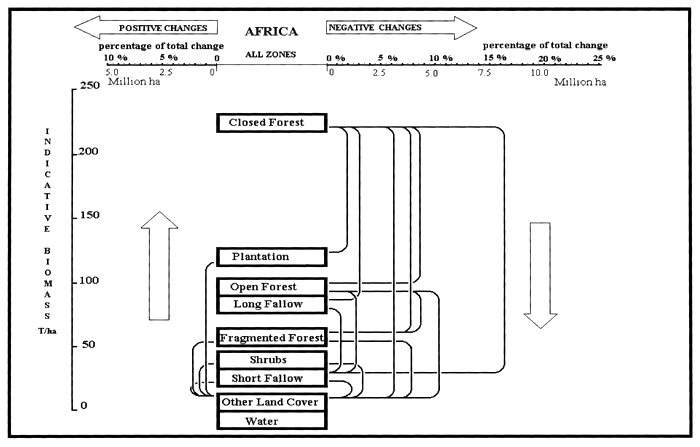
1 Results based on visible common area between recent and historical satellite images. Stable water (ocean, sea, lakes, rivers) has been
excluded from the analysis of changes. The symbol “ε” indicates values below the displayed decimal point.
2 Only class transitions accounting for more than 2 percent of the total change are shown in the diagram.
| Number of Sampling Units: | 39 | Land area studied (million ha): | 87.83 |
| Results expanded to the total land area surveyed (stratum 1,2,3; million hectares): | 1233.56 | ||
| Area transition matrix for the standard period 1980–19901 | ||||||||||||
| Classes at year 1980 | Classes at year 1990 (Million hectares) | |||||||||||
| Closed Forest | Open Forest | Long Fallow | Fragmented Forest | Shrub | Short Fallow | Other Land Cover | Water | Plantations | TOTAL 1980 | |||
| Million ha | % | |||||||||||
| Closed Forest | 742.09 | 2.59 | 3.11 | 3.16 | 1.24 | 6.92 | 24.37 | 1.44 | 0.04 | 784.97 | 63.6 | |
| Open Forest | 0.12 | 81.54 | 0.17 | 0.30 | 0.77 | 0.57 | 3.45 | 0.03 | 0.08 | 87.03 | 7.1 | |
| Long Fallow | 0.12 | 0.11 | 5.63 | 0.10 | 1.00 | 0.14 | 0.01 | ε | 7.11 | 0.6 | ||
| Fragm.Forest | 0.07 | 0.01 | 0.32 | 32.81 | 0.09 | 0.72 | 6.15 | 0.23 | 0.24 | 40.63 | 3.3 | |
| Shrubs | 0.04 | 0.02 | 0.12 | 0.01 | 85.89 | 0.19 | 14.99 | 0.07 | 0.12 | 101.45 | 8.2 | |
| Short Fallow | 0.11 | 0.01 | 0.22 | 0.08 | 0.04 | 13.91 | 3.78 | 0.14 | ε | 18.29 | 1.5 | |
| Other Land | 0.21 | 0.02 | 0.01 | 0.09 | 0.85 | 0.14 | 189.54 | 0.87 | 0.09 | 191.83 | 15.6 | |
| Water | 0.11 | 0.01 | 0.01 | 0.04 | ε | 0.02 | 0.47 | (water) | ε | 0.66 | 0.1 | |
| Plantation | 0.01 | 1.57 | 1.59 | 0.1 | ||||||||
| TOT 1990 | M.ha | 742.87 | 84.32 | 9.60 | 36.49 | 88.98 | 23.46 | 242.89 | 0.79 | 2.15 | 1223.56 | |
| % | 60.2 | 6.8 | 0.8 | 3.0 | 7.2 | 1.9 | 19.7 | 0.2 | 0.2 | 100 | ||
| Woody Biomass Flux Diagram2 |
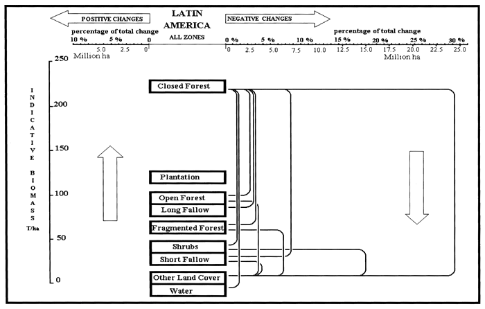
1 Results based on visible common area between recent and historical satellite images. Stable water (ocean, sea, lakes, rivers) has been
excluded from the analysis of changes. The symbol “ε” indicates values below the displayed decimal point.
2 Only class transitions accounting for more than 2 percent of the total change are shown in the diagram.
| Number of Sampling Units: | 29 | Land area studied (million ha): | 59.26 |
| Results expanded to the total land area surveyed (stratum 1,2,3; million hectares): | 610.49 | ||
| Area transition matrix for the standard period 1980–19901 | ||||||||||||
| Classes at year 1980 | Classes at year 1990 (Million hectares) | |||||||||||
| Closed Forest | Open Forest | Long Fallow | Fragmented Forest | Shrub | Short Fallow | Other Land Cover | Water | Plantations | TOTAL 1980 | |||
| Million ha | % | |||||||||||
| Closed Forest | 209.44 | 1.90 | 4.57 | 2.00 | 1.19 | 6.18 | 7.16 | 0.33 | 2.88 | 235.66 | 38.6 | |
| Open Forest | 0.43 | 26.23 | 0.68 | 0.26 | 0.56 | 0.34 | 0.82 | 0.02 | 0.08 | 29.41 | 4.8 | |
| Long Fallow | 0.80 | 0.02 | 35.09 | 1.07 | 0.65 | 0.70 | 1.86 | 0.04 | 0.01 | 40.24 | 6.6 | |
| Fragm.Forest | 0.22 | 0.14 | 0.30 | 14.70 | 0.28 | 0.58 | 1.23 | 0.01 | 0.15 | 17.61 | 2.9 | |
| Shrubs | 0.10 | 0.08 | 0.14 | 0.11 | 10.47 | 0.15 | 2.42 | 0.11 | 0.03 | 13.60 | 2.2 | |
| Short Fallow | 0.24 | 0.17 | 0.15 | 0.28 | 0.12 | 37.86 | 2.30 | 0.04 | 0.10 | 41.26 | 6.8 | |
| Other Land | 0.29 | 0.16 | 0.15 | 0.11 | 0.25 | 0.63 | 218.05 | 0.18 | 0.16 | 219.98 | 36.0 | |
| Water | 0.02 | 0.01 | 0.01 | ε | 0.11 | (water) | 0.02 | 0.16 | 0.0 | |||
| Plantation | 0.04 | 0.03 | ε | ε | 0.01 | 0.07 | 12.41 | 12.56 | 2.1 | |||
| TOT 1990 | M.ha | 211.58 | 28.73 | 41.07 | 18.53 | 13.51 | 46.45 | 234.03 | 0.74 | 15.85 | 610.49 | |
| % | 34.7 | 4.7 | 6.7 | 3.0 | 2.2 | 7.6 | 38.3 | 0.1 | 2.6 | 100 | ||
| Woody Biomass Flux Diagram2 |
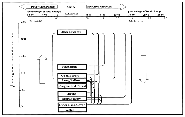
1 Results based on visible common area between recent and historical satellite images. Stable water (ocean, sea, lakes, rivers) has been
excluded from the analysis of changes. The symbol “ε” indicates values below the displayed decimal point.
2 Only class transitions accounting for more than 2 percent of the total change are shown in the diagram.
| Ecological zone | Dominant forest formations | Bioclimatic parameters | ||||
| Mean annual rainfall (mm) | No. of rainy days (length of dry season) | Mean annual air humidity (%) | Mean annual temperature (°C) | Mean temperature of coldest month (°C) | ||
| Zone 1 | Wet and very moist evergreen and semi-evergreen forest | >2000 | >150 (no distinct dry season) | >75 | 22–27 | >23 |
| Wet and Very Moist | ||||||
| Zone 2 | Moist semi-deciduous and deciduous forest, woodlands, and tree savanna | 1000–2000 | 70–170 (2–7 months) | >65 | 22–27 | >23 |
| Moist (with short and long dry season) | ||||||
| Zone 3 | Drought-deciduous and evergreen forests, woodlands, tree savanna; discontinuous thickets, tree/shrub savanna | 200–1000 | 20–120 (7–11 months) | ~50 | 20–30 | >15 |
| Sub-Dry to Very Dry | ||||||
| Semi-arid and Arid zones (not represented within the sampling frame) | Tree/shrub steppe | <200 | <20 (12 months) | <50 | 14–25 | >10 |
![]()
![]()
![]()