![]()
![]()
![]()
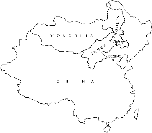
In order to improve the natural environment and social conditions of people in northern China and to speed up the overall development of agriculture, forestry and animal husbandry, in the mid-1970s the Chinese Government began implementing a protection forest development programme in the northwestern, northern and northeastern regions of China, which are seriously affected by sandstorms and soil erosion. The system has come to be known as the "Three Norths" protection forest programme. This article briefly describes the evolution of farm shelterbelt construction in the area and then focuses on specific efforts and the initial results of these interventions, undertaken with the assistance of the Forestry Research Institute, in two townships of Chifeng municipality in Inner Mongolia.
Note: this article has been adapted, with permission, from three papers prepared for the XX IUFRO World Congress, held in 1995: Erosion control development in China: the shelterbelt system in Chifeng, by Zhang Feng and Hou Qing Jiang; Development of farmland shelterbelts in the semi-arid region of northeastern Inner Mongolia, by Fu Jing and Hou Qing Jiang; and Study on water-retaining afforestation in the semi-arid loess hill region, by Zhang Feng. Fu Jing and Hou Qing Jiang. The three authors work at the Forestry Research Institute in Chifeng, Inner Mongolia.
The semi-arid region of northeastern Inner Mongolia (mainly Zhelimu Meng prefecture and Chifeng) lies between the Mongolian high plateau and the Song Liao plain (see Map). The rather broken landscape mainly comprises low mountains and hills, which take up more than half of the total land area, while small plains account for only 25 percent. The average elevation ranges from 500 to 1 000 m. According to the climate division map of China, this region has a semi-arid continental monsoon climate, with quite a distinct spring, summer, autumn and winter. Winter in this region (November-February, <0°C) is dominated by drought, severe cold, strong northwesterly winds and occasional snowfalls. Most of the annual average rainfall of 300 to 450 mm falls in heavy storms during the summer (July-August, >20°C) and is far less than the yearly mean evaporation of 2 000 to 2 300 mm. The dry climate and sparse vegetation have resulted in severe surface erosion and poor fertility of the soil, which has an organic content of only about 1 percent.
Agriculture and animal husbandry are two of the economic cornerstones in the region. Sandstorms, persistent drought and soil erosion are the main limiting factors to agrohusbandry production and overall economic development in the region. To enhance the area's protective capacity against natural damage, ameliorate natural conditions for agriculture and livestock husbandry and increase soil fertility, since the end of the 1940s the local government, under the guidance of forestry researchers, has carried out large-scale afforestation, especially the planting of farmland shelterbelts over large areas.
Three major stages of shelterbelt development can be traced. The first began at the end of the 1940s and continued through to the early 1950s. At that time, shelterbelts were all positioned at 230° from the north, thereby lying perpendicular to the dominant northwesterlies. Each belt was composed of 20 to 30 lines of trees and reached a width of 30 to 50 m. The spacing adopted was 1 x 2, 2 x 1.2 and 2 x 1.5 m, and the distance between belts was about 10 km. Ulmus pumila L. and Populus simonii Corr. were the main species used. It soon became apparent that this technology resulted in wide belts, close spacing and the occupation of too much farmland Farm work was inconvenienced and the individual trees in the shelterbelts became extensively distorted. The choice of species and lack of management led to slow growth and only a slow development of protective capacity. Moreover, as the trees matured, the belts formed a thick, impermeable structure which reduced the maximum protective effect by creating areas of turbulence just beyond the trees.
Co-author Zhang Feng of the Chifeng Forestry Research Institute
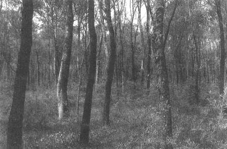
A combination of trees and understorey growth for erosion control on sandy soil
The second stage of shelterbelt development began in the 1950s and continued through to the early 1960s. It was introduced along with broad changes in the management approach to farmland at that time. The belts, which were planted along field boundaries between villages and townships, zigzagged along with divergent widths and spacing. Within an overall shelterbelt, widths ranged from narrow belts of one to two lines to wide belts of 10 to 20 lines. The spacing patterns adopted were still relatively small. Native species such as U. pumila L., P. simonii Corr. and P. pseudosimonii were dominant. Shelterbelts built during this stage were inconvenient for irrigation and mechanization, occupied relatively large amounts of land and, as they followed field boundaries, were only partially effective.
Since the mid-1960s, shelterbelt development has moved into a third stage, where the establishment of windbreaks follows strict scientific principles. In accordance with and as a supplement to principles of agricultural production, instead of small-scale planting along the edges of fields between individual family or village holdings, large blocks of farmland from an entire township or even from several townships have been brought into an overall planning effort. Shelterbelts are interwoven into meshes, forming large-scale networks. At the local level, they are arranged in such a way as to provide maximum protection from prevailing sources of damage. This implies significantly more flexibility than allowed by the rigid approach adopted in the first stage of shelterbelt development. Most of the shelterbelts are planted so as to form 400 x 400 m meshes, with each of the belts comprising three parallel lines of trees planted at 3 x 2 m intervals. This results in a porous structure that provides maximum effective protection with reduced wind damage and debris buildup at the edges of the belt. The species used for the shelter belts are fast-growing, medium-sized crown varieties which give good resistance in the prevailing soil and weather conditions. Populus canadensis Moench, P. euroamericana, P. beijingensis and P. xianohei are among the most widely used species, while a single row of Amorpha fruticosa is often planted on each side of the tree belt to provide understorey protection. A census conducted in 1991 in Chifeng indicated that shelterbelts covered about 26 000 ha, protecting nearly 267 000 ha of fields.
In 1973 (before the Three Norths programme officially began) the Forest Research Institute in Chifeng initiated a research study on planting techniques of water and soil conservation forests on arid loess hills. The research area selected was Cheng-zi township [Ed. note: "township" is used here to refer to an administrative area and not exclusively a "town"], a typical loess hill area which is characterized by drought, frequent cold and strong winds and severe soil and water erosion. Paying equal attention to agriculture, forestry and animal husbandry, researchers combined biological and engineering measures in the establishment of soil and water conservation forest, with grassland and farm shelterbelt networks as the major elements.
Starting with the broad valley area, which extends about 60 km, 102 farmland shelterbelts were established, providing protection for approximately 2 200 ha. Subsequently, an additional 1 600 ha of grassland and farm shelterbelt networks were established on the gentle loess hills surrounding the main valley. The system was based on the formation of shelterbelt meshes in which herbaceous and grass crops were rotated with grain production, primarily for livestock feed. Overall, the township's forest cover increased from 2.9 percent in 1970 to nearly 34 percent in 1994.
Observed benefits
Restoration of soil productivity. Before afforestation, as a result of severe soil and water erosion, the fertility of the hillside fields in Cheng-Zi township was very low. The herbaceous cover, mainly thyme(Thymus sp.), was of very poor quality and low productivity, and some of the fields were abandoned and turned into barren grazing land.
This situation changed with the establishment of various types of shelterbelt networks and the planting of slope protection stands as well as grass or herbaceous crops within the meshes and young trees in the spaces between the networks.
The growing of introduced ground cover species (both herbaceous and grass) in the shelterbelt meshes has greatly raised grass output and soil quality. For example, the output of fresh Daghestan sweet clover (Melilotus suaveoluna) can reach 6 000 to 11 250 kg per hectare and fresh Astragalus adsurgens 7 500 to 15 000 kg per hectare, more than ten times as much as that of natural grassland species. Green manure from Daghestan sweet clover increased organic matter in the ploughing layer from 0.68 to 1.48 percent and the total nitrogen content from 0.068 to 0.14 percent.
After the soil fertility had been raised by the herbaceous ground cover in the meshes, the subsequent grain output on the same area increased from 300 to 1 050 kg per hectare and the total grain output in Cheng-zi township reached four times its previous level, also owing to the fact that the shelterbelt networks permitted grain production in areas where it had previously been impossible. Another result was a 56 percent increase in livestock production.
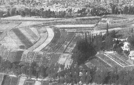
Chifeng municipality located in the semi-arid region of Inner Mongolia
Improved water and soil conservation. The combination of afforestation, herbaceous ground cover cultivation, improved site preparation and water and soil conservation measures has produced clear results: runoff has been reduced by 94 percent and erosion by 98 percent in comparison with the previous bush fallow land use.
Increased tree growth. The cultivation of a herbaceous ground cover together with the trees in the shelterbelt networks has improved the nutritional condition of the trees. Leguminous plants, in addition to their nitrogen-fixation properties, can produce a large amount of roots in the soil, even more than their above-ground biomass. When these roots decompose, the organic material of the soil increases, thereby improving its physical and chemical properties. Populus chenfonii and P. simonii planted on the former grassland showed a height increase of between 59 and 75 percent and a diameter increase of between 67 and 70 percent.
Initial conclusions and observations for future work
The combination of techniques used in the study area appear favourable for forestry, animal husbandry and agriculture. A significant improvement in water and soil conservation has been achieved with a parallel increase in the output and quality of agriculture and animal husbandry. Therefore, not only is the shelterbelt network and its protected farmland and grassland a good ecological system, but it is a better combination of agriculture, forestry and animal husbandry.
Although setting up shelterbelt networks on grasslands and farms is an important measure in speeding up afforestation and expanding the forest area, the shelterbelt networks must be developed in a flexible manner that is appropriate to local conditions and needs. For example, meshed shelterbelt networks should be avoided in places where the topography varies greatly or slopes are more than 15°. On particularly steep slopes or on the ridges of hills, where there is intensive gully erosion and broken topography, corridor-like shelterbelts should be used. These belts run vertically downhill in parallel 5 to 10 m bands and are linked at both ends by gully erosion belts which run across the slope. This kind of shelterbelt can stretch as far as desired and is-suitable for any kind of hillside slope. Corridor shelterbelt networks often occupy as much as half of the total land area. High-density slope protection stands should be established on slopes with heavy soil erosion.
The measures described above have shown that the combination of afforestation and herbaceous ground cover cultivation can restore vegetative cover and enrich the soil rapidly, thus creating favourable conditions for the development of agriculture and animal husbandry. Tree planting on former grasslands and the application of green manure to young trees can promote the growth of trees. According to our observations, the rotation of herbaceous and grain crops can be conducted in the meshes of shelterbelt networks even in the early years after afforestation.
Taiping Di township used to be a poverty-stricken area with bare, poor-quality lands and frequent sandstorm and wind damage. Under the technological guidance of the Forestry Research Institute, in 1966 a total of 401 shelterbelts were planted, forming a mesh of 375 protected areas. As the network began to take shape, various ecological benefits emerged: according to field observations, wind velocity within the belts decreased by 32 to 38 percent compared with unprotected areas; free water evaporation was 660 mm less than in unprotected areas over the course of a year; absolute humidity increased by 7 percent compared with outside the shelterbelts; and the soil moisture content was 3 to 6 percent higher. Winter temperatures inside the belts were 0.5 to 1.6°C higher than those outside, while summer temperatures were 0.1 to 0.7°C lower.
On 10 May 1981, Chifeng municipality was hit by a particularly severe sandstorm, lasting 68 hours. Maximum wind speeds reached up to 10 or 11 grades on the Beaufort scale. During the storm, ground visibility reached zero, road and rail transportation was blocked for three days and a total of 170 000 ha of crop fields were devastated. In contrast to the damage done generally, the 4 300 ha of cropland protected within the meshes of shelterbelts in Taiping Di survived well, while the nearby 3 100 ha of unprotected fields lost 20 to 30 cm of topsoil. This is a positive example of the ecological benefits offered by shelterbelt networks.
The economic benefits of the shelterbelt network have been seen in two areas, crop yield and timber production. Yields of two of the major crop species, maize and millet, were 64.2 and 70.6 percent higher, respectively, inside the belt than outside. As for wood production, the current stand volume of shelterbelts in the whole township is 112 700 m³, with an annual increment of 20 000 m³. Selective cutting began in 1982, with a yearly timber production of 2 500 m³ and annual wood product values of 45 000 yuan renminbi (Y).Wood industries bring in an income of Y 5 000 000 annually.
Social benefits were realized through the direct investment of nearly Y 50 000 in agriculture, education, local industries and rural education. At the same time, nearly Y 150 000 from forestry income were set aside as a fund for further development.
As mentioned earlier, farmland shelterbelt development in northeastern Inner Mongolia has developed in three stages. The approach adopted in the current stage appears to be giving significant positive results. However, continued monitoring will be necessary over a longer period before definitive conclusions may be drawn. Current efforts to refine the approach further include attempts to extend the distance covered by protective belts, increase comprehensive protection, reduce the accumulation of soil and organic matter near the belts and lower costs as well as the minimum amount of land occupied by the tree component of the system. Within the tree component, improved varieties and high-quality clones are being used, thereby increasing the speed at which shelterbelts become effective and also increasing their biomass production. To conclude, farm shelterbelt establishment in northeastern Inner Mongolia is a changing process that should continue to evolve and develop.
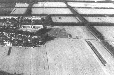
The forest network at the edge of Chifeng city, Inner Mongolia
![]()
![]()
![]()