![]()
![]()
![]()
M. Meunier
M. Meunier works at CEMAGREF, an agricultural engineering and environmental research establishment in Saint-Martin d'Hères, France.
Lessons from the experimental watersheds of Draix and Real Collobrier in France.
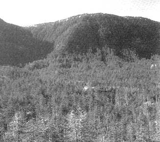
An overall view of the Laval watershed, evidencing the lack of vegetation
It is generally accepted that forests play a major role in many components of the water cycle, and this article focuses on the influence of forest cover on runoff. Although a number of studies have dealt with the forest's impact of forest cover on water tables, cloud formation, snow, etc., these are not covered in this article. The comprehensive bibliographical review by Humbert and Najjar (1992) amply demonstrates the wide range of research topics in this field, regarding both "the impact of forests on the water cycle" and "the role of trees in specific climatic conditions".
It is mainly believed that forest cover reduces runoff, although some assert otherwise (see Humbert and Najjar, 1992). However, merely saying so is not particularly helpful to hydrologists if they cannot quantify the effect. The reduction in runoff varies according to the forest species as well as the season, and is by no means constant for all expanses of area or for all rainfalls. A number of difficult but crucial practical questions thus arise: What is the rainfall threshold at which forests can no longer curb runoff? At what degree of plant cover does the forest begin to have a significant effect on flooding? Is wholesale deforestation in some parts of the world responsible for the widespread devastation caused by major floods? Some scientists actually dispute the fact that forests are very effective in protecting against such events (Ives and Messerli, 1989).
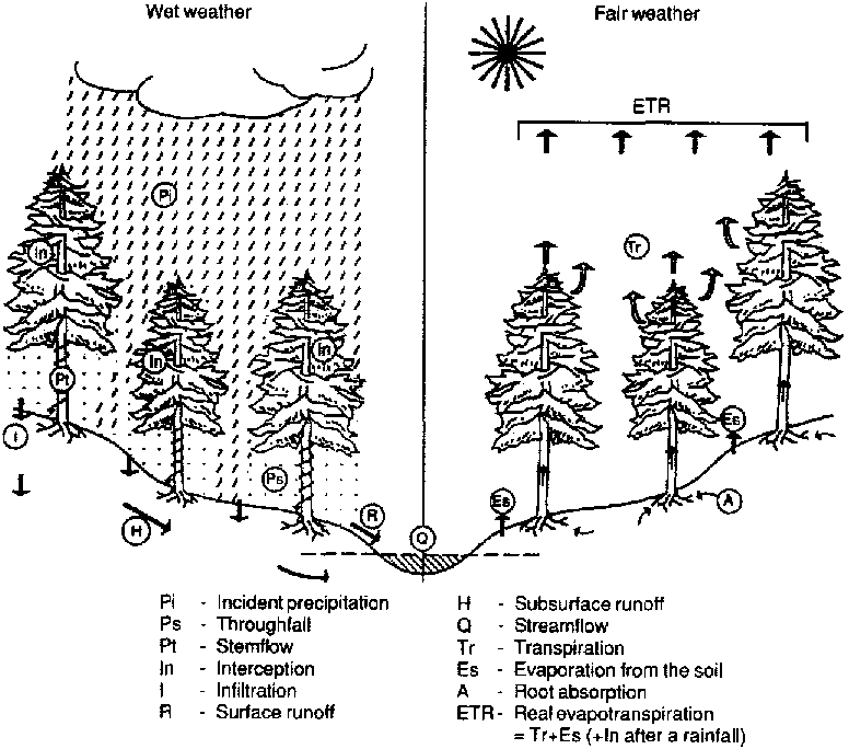
To quantify the reduction in runoff resulting from forest cover, it is necessary to spell out and analyse the processes that produce this effect (throughfall, interception and the storage role of the soil) (Fig. 1). An initial qualitative analysis will pinpoint the size of the areas and time scales involved, as governed by the measuring techniques used. The article will then look at findings from gauging stations in southeastern France to compare small forested and unforested watersheds in mid-altitude mountain zones.
Figure 1 illustrates the basic notions and the exchanges of water in liquid or gas form between the air, subsoil and surface environments. The figure compares two situations, rainy and fair weather, that water circulation differs in each. In this it follows that similar measurements (particularly evapotranspiration) should not be interpreted in the same way for both cases. What happens during a rainy period depends essentially on the rainfall whereas in fair weather it depends on stored water. The period during which the exchanges are studied is therefore very important and it is essential to specify whether the study covers one rainfall or a longer time scale (e.g. a month, season or year), comprising alternating dry and rainy periods. The daily scale, often used for the sake of convenience, can refer to dry or wet weather.
The movement of water between different environments (see Fig. 2) indicates that: the above-ground layer of trees interferes with the path taken by the raindrops. The rain that drips from the canopy and the stemflow make up the throughfall, and these quantities can be measured, unlike interception which is calculated by deduction. In spatial terms, therefore, these are specific measurements while, in temporal terms, they can be taken at any moment. The same applies to interception, a concept which covers several processes, such as evaporation, transpiration and leaf absorption, and which will only be examined here in very general terms.
By interacting with the soil, the forest root system is crucial in transforming throughfall into runoff (Germane, 1994). This process takes place at two levels: at the soil surface, where the rainwater separates into surface and subsurface runoff (determined by infiltration velocity); and at the level of water storage and the subsurface runoff routes (determined by retention capacity and hydrological conductivity). The action of the forest root and soil systems is evident with every rainfall. It is often considered to vary little from one flood to another, provided the groundwater reservoir is identical at the onset of each storm. The forest-soil influence, which naturally determines the development of the forest soil over time, is an extremely slow process, occurring over a period of decades. Rapid and substantial changes (caused by fires or clear-felling) in a watershed's surface mainly seem to affect the interception of rain, but their impact on the forest soil, and hence on runoff, varies widely with the type of watershed. For example, few tangible effects have resulted from clear-felling carried out in the Lamge Brake watershed (Nys, 1959) whereas flash flooding has been very noticeable since there was a forest fire at Rimbaud (Lavabre, Sempere-Torres and Cernesson, 1991).
Quantifying the influence of the subsurface part of a forest is a complex matter, as it entails calculating the difference between runoff and throughfall. However, the throughfall is rarely recorded in forests; ordinary rainfall measurements and rates of flow only show the combined action of the above-ground and subsurface forest layers.
It is difficult to trace the path of subsurface runoff on a slope. Although the flow is gauged at a specific site, it is hard to know the exact source of the runoff being measured. Runoff measurements are generally taken at the level of a large watershed, in which case the natural depression of the slopes may be assumed to cause the subsurface and surface runoff to converge at the gauging station.
FIGURE 1. The water cycle in a forest
Source: Humbert and Najjar, 1992.
FIGURE 2. The forest's influence on the water cycle: above-ground and subsurface
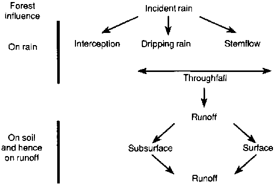
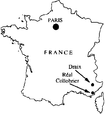
FIGURE 3. Location of the Draix and Réal Collobrier watershed sites
To sum up, when measuring the influence of forest cover on runoff, it is necessary to specify three types of data:
· The time scale referred to: annual, monthly or seasonal; the duration of a particular rainfall, etc.· The spatial scale: one tree or several trees, a measurement parcel such as a Wischmeier plot or an entire watershed, in which case its size needs to be specified.
· The type of action measured: the forest's impact on rainwater alone or its impact on both the rainwater and runoff.
The degree of interception occurring during a rainfall can be measured either by the real event or through rain simulation experiments. The data are often expressed as a percentage of the incident rainfall, with the percentage decreasing when the incident rainfall increases. For the purpose of this paper, which considers the effect of forest cover on flooding, the most important data refer to the amount of interception that occurs during one rainfall, mainly to see whether there is a maximum threshold for the forest's above-ground storage capacity.
To test this hypothesis and to quantify saturation capacity, interception measurements were taken at a specific site in the experimental watersheds of Réal Collobrier (Fig. 3) (Duwig, 1994; Biron, 1994; FAO, 1962) and, assuming a forest cover saturation point, a theoretical model was created (Biron, 1994) and adjusted in accordance with the actual measurements. The conclusion reached was that interception peaks at about 5 mm in northern France (the Biron experiments) and around 12 to 14 mm in the south of France (the Duwig experiments), the difference between them presumably being due to the evaporation difference between the two gauging stations. It would appear that the above-ground layer of the forest cannot possibly account for a sharp decrease in throughfall in the case of heavy rainfalls (tens of millimetres) and much less so in the event of disastrous storms (several hundred millimetres).
This article discusses the effect of the forest on flood formation, but equally important is the role it plays in erosion control owing to the combined effect of:
· the direct effect of reducing rain-splash;· the indirect effect of reducing surface runoff and hence the volume of sediment that is removed and transported;
· the indirect effect on runoff (delayed runoff, increased infiltration, etc.) of forest soil, which blocks and stores solid matter, particularly coarse sediment.
The quantitative results are clearly expressed in terms of the sediment load, measured on the experimental Draix watersheds (the forested Brusquet watershed and the denuded Laval watershed) where the interannual average rate of sediment transport was 177 tonnes per hectare at Laval and only 4 tonnes at Brusquet (Meunier, Mathys and Cambon, 1995).
The next stage is to examine the importance of the subsurface forest layer in the formation of surface runoff. This was done using a rain simulation experiment designed to quantify the influence of vegetation on soil infiltration by measuring runoff on the forested terrain and then taking the same measurement for the same area after having removed all vegetation, including roots (Grésillon, 1994). The results showed quite clearly that soil containing roots is able to absorb virtually all the rain by infiltration (180 mm out of 196 mm per hour for more than two hours) and that the surface run off is therefore virtually zero, even in the case of very heavy rain. Only in the event of soil saturation (which was not measured in the experiment) might the movement of soil water towards deeper strata be altered. When the vegetation and its roots are removed, infiltration is greatly reduced (to a very low level of about 10 mm per hour compared with an incident intensity of 134 mm per hour for 45 minutes). In this case it is surface runoff which predominates.
This experiment has major implications, confirming that the main impact of vegetation on flooding derives from the alterations it makes to the soil through a combination of actions such as root formation and leaf litter and humus formation. It is therefore soil type and soil depth that must be compared to establish the impact of reforestation or replanting on flooding in a specific watershed. Deep, permeable soil can be infiltrated whether it is bare or not. In the latter case, the additional impact of vegetation on runoff will be minimal. However, mountain watersheds often have rather shallow and/or impermeable soil beds, so by allowing a rapid infiltration of rainwater, vegetation plays a critical role.
In conclusion, on a small scale it is possible to consider the hydrological function of mountain soil by ranking it somewhere between the two extremes of soil with and without vegetation:
· Soils without vegetation mainly cause surface runoff, with a minimal rate of runoff delay and infiltration. Consequently, the hydrological behavior of a predominantly bare watershed can be studied on the understanding that it principally creates surface runoff.· Vegetation-covered soil would cause infiltration rather than surface runoff. Hydrological activity at the watershed level therefore depends on subsurface runoff, with the possibility of both a transfer towards deeper water tables (an ambiguous term when dealing with mountain watersheds) and increased surface runoff in thalwegs.
Real life situations fall somewhere between these two extremes; the problem is calculating exactly where. Moreover, the issues facing hydrologists concern what is happening on the much larger scale of an entire watershed or catchment area. However, surveys (Ambroise, 1991) on the isotopic nature of floodwater suggest that, even at the watershed level, the difference between soils with and without vegetation also applies. The following section examines the situation in terms of the rate of flow in two experimental watersheds at Draix.
The contrast between the two extremes of floodwater formation that emerged in the previous section shows that the extent of forest cover is a very important factor. The example of the Draix watersheds will now be used to quantify the effect of forest cover on runoff at a spatial scale of about 1 km² in watersheds consisting of black marl and a badland facies, with an altitude of 700 to 1 200 m and an average annual rainfall of about 800 to 900 mm. The Laval and Brusquet watersheds have been chosen because they are sufficiently small and homogeneous to ensure that one single predominant factor - their vegetation - can explain the differences in their hydrological activity. The extent of denudation is 78 percent for Laval and only 13 percent for Brusquet.
These watersheds, which are managed jointly with the Service de Restauration des Terrains en Montagne des Alpes de Haute-Provence, are in the municipalities of Draix and Brusquet. They are made up of highly eroded black and limestone marl, which is why one of them (Brusquet) was reforested at the end of the nineteenth century. Because the rainfall, flow discharge and sediment load have been measured since the period 1984-1987 (Cambon et al., 1990), the results can be compared to ascertain the overall effect of forestation on floodwater formation.
Several methods may be used to compare flooding in the two watersheds. Two are discussed here.
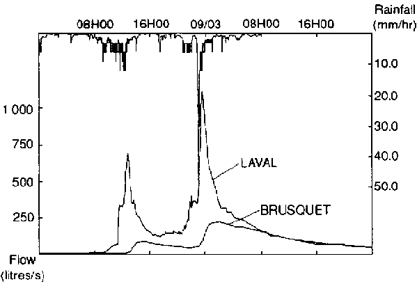
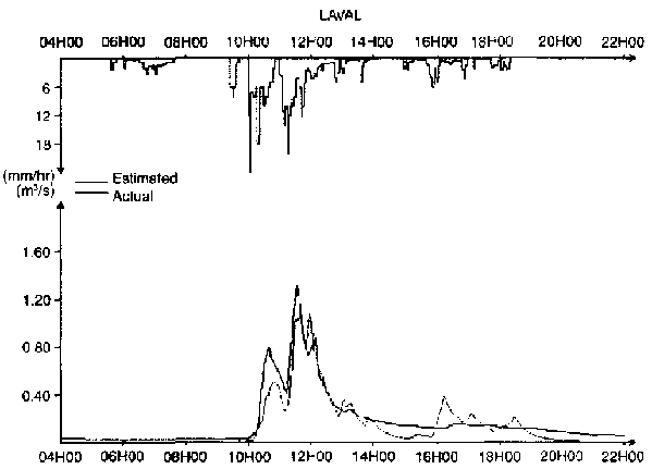
The direct comparative method. This consists of directly comparing the results of actual measurements. To do this, all other things must be equal, meaning at the very least that the rainfall events causing the flooding must be as similar as possible. Figure 4 shows the floodwater hydrographs of 8 and 9 March 1991 for both watersheds. It illustrates clearly that the Laval watershed responded quickly, that the hydrograph immediately picked up the storm profile (a "flash flood" response) and that the floodwater values are higher than at Brusquet. The figure supports, at the watershed level, the same conclusion reached earlier: the concept of surface or rapid runoff may be applied to the deforested watershed, while the concept of delayed or subsurface runoff (whether it be in the upper or lower soil strata) may be applied to the forested watershed. In the Rimbaud watershed of Réal Collobrier, after 80 percent of the vegetation had been burnt (Lavabre, Sempere-Torres and Cernesson, 1991), the same kind of "flash flood" response to rainfall was found, which was very different from the behaviour of the watershed before the fire.
Many other examples of flooding could also be given to illustrate something which is now evident; namely that, for the Draix watersheds, the forest cover delays and reduces the volume of flooding.
FIGURE 4. Floodwater in the Laval and Brusquet watersheds, 8 and 9 March 1991
The linearity hypothesis. A quantitative analysis requires a number of assumptions regarding a watershed's type of reaction to rain, based on the hydrograph produced. The above-ground forest layer, as indicated earlier, stores part of the incoming rain (i.e. interception). The forest soil also plays a complex role by storing water either temporarily or over a longer term. Therefore, the initial state of the watershed is also important, and all these effects suggest that the transformation of rain into flowing water is not linear; in other words, the rate of flow is certainly not proportional to the rainfall. An average rainfall after a period of drought might not give rise to any flow at all, whereas the runoff from a light shower in a saturated watershed might be very close to the total volume of rain.
Consequently, the linearity hypothesis is unrealistic, although it does provide a ready response that is easy to understand. Despite the risks of misinterpretation, it is being adopted here at this stage. The peak flow of the two watersheds considered can be compared either directly, if both watersheds have the same rainfall (in terms of quantity and structure), or by using a coefficient of runoff if the rainfall is different in each case.
Figure 5 gives the result of the first comparison. It shows that most of the flow rates from the forested watershed are less than one-fifth of the corresponding rates (namely, the peak flow during the same rainfall) from the unforested watershed and that, on average, they are of a lesser magnitude. The events of 9 April 1987 differed sharply between them, the reason being the long non-linear character of the floodwater formation process and the relevance of the initial conditions. The rainfall on that occasion was very heavy, and the maximum was reached towards the end during a second flood crest when the first (29 mm of rain) had perhaps saturated the soil. It was therefore natural that runoff considerably exceeded what it would otherwise have been had the soil not been saturated. Conversely, when the flow at Brusquet is very low (as during the 20 August 1988 event) it is because a short, heavy downpour, which will barely cause runoff at Brusquet (23 mm of rain), sets off an intense and rapid runoff at Laval. Moreover, the number of occasions on which there has been runoff at Laval but none at Brusquet points to the existence of a minimum runoff threshold (which would be a non-linear effect, if any) but these events have not been incorporated into this graph.
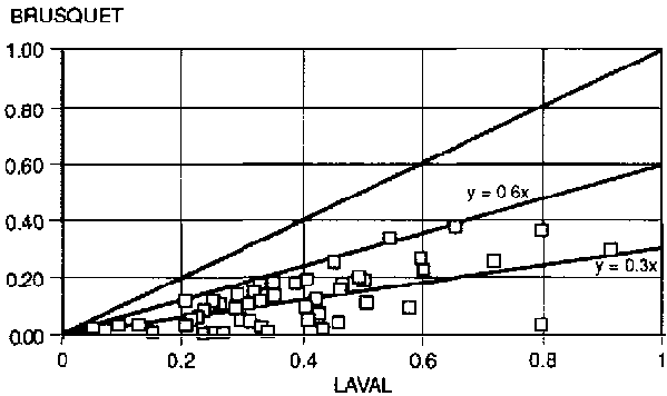
The second comparison (Fig. 6) relates to the coefficients of runoff and also refers to occasions where there was runoff simultaneously in both watersheds. The use of this parameter is much more controversial than the peak flow because a definition of floodwater volume is always ambiguous. Moreover, in the case of the Draix experimental watersheds, the low discharge rates have been measured very roughly. Bearing in this in mind, Figure 6 shows that the forested watershed runoff coefficients were on average only 30 percent of those for the unforested watershed.
In conclusion, comparisons made on the assumption that runoff phenomena are linear allow us to quantify the effect of forest cover compared with a bare watershed. For average rainfalls and for mid-altitude mountain watersheds similar to those of Draix, forest cover probably cuts the peak flow by at least 80 percent and runoff volumes by at least 40 percent.
FIGURE 5. Comparison of peak flow rates (in litres/s) in a forested and unforested watershed
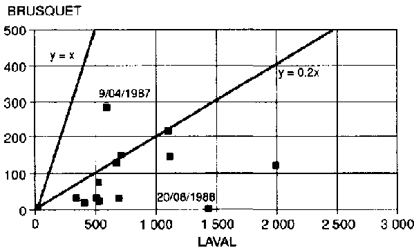
FIGURE 6. Comparison of runoff coefficients in a forested and unforested watershed
There are exceptions, as indicated above, but these can usually be easily explained on the basis of an intuitive model of the overall physical behaviour of watersheds. It thus makes sense to give closer thought to using a model of this kind.
A more physical approach based on a series of assumptions regarding the hydrological activity of watersheds will now be tested and used to compare the two watersheds under study. Many models are available to forecast watershed activity during runoff formation. The GR2 model used here (Michel, 1991) postulates the existence of two reservoirs, A and B, between which the incident rainfall is distributed. Reservoir A represents the mechanisms of subsurface runoff formation while Reservoir B represents the mechanisms of surface runoff (the delay before and the reduction in runoff, etc.). A third parameter makes it possible to take the initial conditions into account (Michel, 1991; Brochot, 1995).
An initial assumption is that distribution between the two reservoirs is determined by the level (a) of Reservoir A. This reservoir constantly receives a fraction of the rain equal to

while the other fraction goes into Reservoir B. The greater the capacity of Reservoir A, the more rain it can hold, the less there is to go into Reservoir B and, consequently, the less there is left to form runoff.
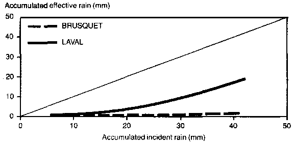
If the GR2 model is applied to the rains recorded at Laval and Brusquet, it gives values for A of 25 mm for the former and 125 mm for the latter watershed. Based on an incident rainfall of 42 mm, Figure 7 shows the evolution of "effective rain", i.e. rain producing runoff, as a function of the accumulated incident rainfall for both watersheds. The figure also shows the huge water storage potential of the Brusquet forested watershed compared with Laval.
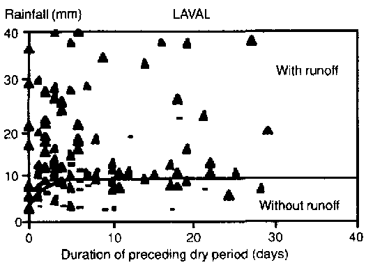
A second set of assumptions relates to the initial soil water content at the beginning of the rainfall. These conditions must be identified and their role in floodwater formation determined. Quantifying the saturation level of the watershed at the beginning of a rainfall is not easy, except in very rare cases where the water content of the soil has already been recorded. The streamflow at the onset of a rainfall is often an excellent indicator of the initial state of saturation. In the case of the Draix watersheds, since the streams are wadis and are therefore dry when not in flood periods, this solution is not always practicable. The "maximum rainfall" curve was therefore used to show the division between the occasions on which surface runoff occurred and those on which it did not. The values of this maximum rainfall vary in terms of the duration of the dry period prior to the rain, and it can therefore be used to represent the initial state of the watershed. A comparison of these two curves for both watersheds (Fig. 8) shows the effect that different percentages of forest cover have on flooding. A rainfall of R 1. max = 9 mm is sufficient to cause runoff at Laval whereas, at Brusquet, after a relatively long dry period, runoff might begin only after R1 max has reached 25 mm. This shows that forest cover multiplies the initial pre-runoff storage capacity by a factor of 2.5.
FIGURE 7. Increase in effective cumulative rainfall in terms of cumulative incident rainfall for a forested and unforested watershed
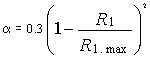
To understand the effect of the initial conditions on the filling of Reservoir A, it was simply assumed that the reservoir was not empty at the onset of the rain but had an initial level of a0 = (x A. This level was adjusted in accordance with the real rainfall records (together with parameter A) and was linked to the maximum values of rainfall (R), indicated by the curves in Figure 8. The correlations are not very strong but it is interesting to note that the ratios obtained (Brochot, 1995) are the same overall for both watersheds:
It is therefore possible to use this formula and the maximum rainfall curves to predetermine the initial level (a0) of Reservoir A.
The last assumption to represent runoff formation in the watersheds relates to the activity of the surface Reservoir B. The GR2 model is based on the assumption that its level (R) rises as it receives the fraction

of the rainwater but, at the same time, it empties at a flow rate of Q which depends on the level (R) of the reservoir (see the following formula):

The b parameter, obtained by applying the formula to real situations, refers to the emptying capacity of Reservoir B: the greater its capacity, the more slowly the reservoir empties. This parameter is inversely proportional to the time scale used for the calculations. The values obtained for b (for a five-minute time scale) are 14 for Laval and 96 for Brusquet (Brochot, 1993), which clearly shows that the reduction in runoff brought about by the forested watershed is far higher than that effected by the unforested watershed. It also shows that the b parameter falls if the intensity of the rain increases sharply.
Figure 9 shows the model applied (for validation and not for practical purposes) to the rainfall of 18 July 1987, for which the gap between the watersheds' peak flows was one order of magnitude. With 23 mm of rain recorded, this fall is quite representative of average rainfall events. The figure shows that the model correctly reproduces both hydrographs for this event but that the curve varies widely from one flood to another.
Statistical comparison
In the preceding sections, the floodwaters of the two watersheds were compared for concomitant events: it is also possible to compare the statistical theorems governing their maximum annual rates of flow. Figure 10 (p. 36) gives the value of these annual maximums in terms of the reduced variable of Gumbel's Law. The samples are quite correctly aligned, which shows that Gumbel's Law illustrates relatively accurately the variation in the time it takes for the floodwater to return in terms of its flow rate. But, above all, it shows that, when the return rate is the same (and hence the value of the reduced variable of Gumbel is the same), the flow rates of both samples are separated by a factor of 10. To conclude, the statistical laws of maximum flow rates faithfully translate the gap of one order of magnitude between the peak flow rates of the forested watershed and those of the degraded watershed.
FIGURE 8. Maximum rain curves for the Laval and Brusquet watersheds
Laval
Brusquet
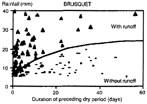
FIGURE 9. Comparison of the actual and estimated hydrographs based on the GR2 model for the rainfall of 18 July 1987
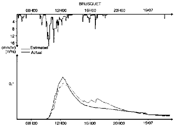
FIGURE 10. Statistical laws of maximum annual peak flow rates for the Laval and Brusquet watersheds
The findings from Draix confirm the fact that forest cover is pivotal in floodwater formation in mountain areas and must not be ignored. Analysing the activity of small mountain watersheds in southeastern France during flooding shows that the peak flow rates of the forested watershed and the degraded watershed vary by a factor of 10. The forest cover plays an effective role in intercepting the rain, acting as a temporary storage reservoir to soak up runoff and reduce the velocity of the flow.
In theory, floodwater formation in mountain watersheds should be easier to understand than in lowland watersheds. The homogeneity of the physical parameters is greater and, in terms of vegetation for instance, watersheds may often be neatly divided into particular types: for example completely unforested or completely forested. Experts faced with the problem of quantifying the floodwater of small mountain watersheds nevertheless find it a particularly difficult task. This is mainly due to the fact that there are only a small number of hydrometric and rainfall measurement stations, which makes it difficult to design reliable hydrological methods. For example, the formulas drawn up in France to estimate ten-year flow rates do not include plant cover as an explanatory variable. This means that the formulas are not necessarily suitable for calculating floodwater discharge rates from small mountain watersheds. Therefore, to predetermine the discharge rates of these small watersheds, it is often necessary to use very simple methods based on a qualitative understanding of floodwater formation. In such cases it is useful to take the two extremes, i.e. the completely forested or completely unforested watershed, as benchmarks. The results obtained from the Draix watersheds show that this is a sound approach because the values for the floodwaters of both watersheds, forested and unforested, differ by one order of magnitude.
These results may therefore be used to predetermine the flow rates of other watersheds that are of a similar type and size. Furthermore, simulation methods may be adopted using very simple models such as the GR2 model discussed in this article. However, it is not easy to extrapolate the parameters of the models. A similar survey of other sites would be needed, including hydrometric and rainfall records, and all the results obtained from the largest possible number of watersheds would have to be compared in order to produce a truly appropriate methodology for small mountain watersheds.
Ambroise, B. 1991. Hydrologie des petite bassins versants ruraux en milieu tempéré Processus et modèles. In P. Stengel, ed. Transferts dans les bassins versants. INRA Un point sur... Series. Paris, INRA.
Biron, P. 1994. Le cycle de l'eau en forêt de moyenne montagne: flux de sève et bilans hydriques stationnels (Bassin versant du Strengbach á Audure Hautes Vosges). Louis Pasteur University, Strasbourg, France. (Ph.D. thesis)
Brochot, S. 1993. Erosion de badlands dans le système Durance-Etang de Berre. Corsica, CEMAGREF-Agence de l'Eau Rhône Méditerranée.
Brochot, S. 1995. Desertification in the Mediterranean area. European DM2E project Final report of Project EV5V-CT91-0039. Grenoble, France, CEMAGREF.
Cambon, J.P., Mathys, N., Meunier, M. & Olivier, J.O. 1990. Mesures des débits solides et liquides sur des bassins versants de montagne. In Symposium: Hydrology in Mountainous Regions. AIHS Publ. No. 194 Lausanne Switzerland, AIMS.
Duwig, C. 1994. Elément de modélisation de l'interception des pluies par quatre espèces d'arbres de type méditerranéen. DEA Mécanique des Milieux Géophysiques et Environnement. UJF. Aix-en-Provence. France, CEMAGREF.
FAO. 1962. Forest influences: an introduction to ecological forestry. FAO Forestry Series No. 9. Rome.
Germann, P.F. 1994. Do forests control runoff? Beitr. Hydrol. Schweiz., 35: 105-110.
Grésillon, J.M. 1994. Contribution à l'étude de la formation des écoulements de crue sur les petite bassins versants. Approches numériques et expérimentales 3 différentes échelles. Diplôme d'habilitation 3 diriger des recherches. Laboratoire des Transferts en Hydrologie et en Environnement. Joseph Fourier University, Grenoble, France. (thesis)
Humbert, J. & Najjar, G. 1992. Influence de la forêt sur le cycle de l'eau en domaine tempéré. Une analyse de la littérature francophone. Strasbourg, France, CEREG.
Ives, J.D. & Messerli, B. 1989. The Himalayan dilemma - reconciling development and conservation. London, Routledge.
Lavabre, J., Sempere-Torres, D. & Cernesson, F. 1991. Etude du comportement hydrologique d'un petit bassin versant méditerranéen après la destruction de l'écosystème forestier par un incendie. Premieres analyses. Hydrol. continentale, 6(2): 121-132.
Meunier, M., Mathys, N. & Cambon, J.P 1995. Panorama synthétique des mesures d'érosion effectuées sur trois bassins du site expérimental de Draix. Compte rendu de recherches No. 3. BVRE de Draix. Série Etudes No. 21. Draix France, Département Equipements pour l'Eau et l'Environnement.
Michel, C. 1991. Hydrologie appliquée aux petite bassins ruraux (2 vole). Antony France, CEMAGREF.
Nys, L. 1959. Remarques sur l'effet hydrologique d'une coupe à blanc. Mitteilungen der Schweizerischen Anstalt für das forstliche Versuchswesen, 35(1): 81-84.
![]()
![]()
![]()