![]()
![]()
![]()
This article considers some emerging information technologies that are becoming important for many forestry organizations as tools to improve strategic and tactical planning and operations management and control.
D. P. Dykstra
Dennis P. Dykstra is Director-General for Research, Center for International Forestry Research, Bogor, Indonesia.
Like all ages in the development of human civilization, in today's world the power of information drives our governments, makes our industries productive and competitive and enriches our personal lives. Humans today are better informed than at any previous time in history, but they are also assaulted daily with a barrage of information which is of no direct relevance to them, cannot be used because of inadequate technology or understanding, or is actually misleading and potentially harmful to them or to their organizations. In today's world it is not enough for managers to understand the business or organization for which they are responsible; they must also be able to manage the relentless flow of information, selecting what is relevant to the proper functioning of their business or organization and ignoring what is irrelevant or misleading for them. They must also recognize information that is needed but is not currently available or able to be used, and they must put in motion the processes that will enable them eventually to obtain and make use of this information.
This is easy to say but difficult to practice. Few foresters have had training in the information sciences. Even for specialists in information systems, the half-life of knowledge in this field is estimated to be about two years. This means that, after two years, half of what is currently considered the state-of-the-art in information management will have become obsolete. This is due principally to the rapid pace of technological development in information systems.
To some extent, of course, this has always been the dilemma of managers; as time passes their technical knowledge risks becoming outdated. In today's world this occurs faster than ever before, as effective management requires an understanding of information technology, and how to make it function on behalf of the manager's organization, as well as technical skills.
Information has always been an important "stock in trade" of forest managers. Knowledge of tree species, stand age, growth characteristics, site quality, soil and terrain classes, logging costs and product markets have all been essential for profitable forest management for many decades. What has changed is the technology for collecting, analysing and presenting this information, and particularly the speed at which this can be done. Whether they like it or not, forest managers must also be information managers. In particular, they must understand the implications for forest management of new types of information and new information technologies and they must understand how information needs will affect both the personnel and structure of their organizations.
Most authorities on forestry information systems recognize three types of information needs (FAO/ECE/ILO, 1992): i) information for strategic planning and analysis; ii) information for tactical (medium and short-term) planning; and iii) information for operational management and control. Each of these has its own requirements, although to some extent the technologies overlap.
For any organization, the most fundamental strategic question is "What business should we be in?" In some cases, such as state forestry agencies, this question has a more or less obvious answer, although some of the details may change from time to time (e.g. some assets may be divested through privatization, or the organization's relative emphasis on production forestry versus amenity forestry may change). In the case of private enterprises, the question has no obvious or fixed answer. As conditions change, enterprises must change also or they will cease to be competitive. Thus, forestry enterprises should always be asking this question and they should always be open to the possibility of new answers.
|
A tale of two companies: "What business should we be in?" In the early 1970s two forest companies in the State of Oregon were both largely dependent on the United States Forest Service for their timber supplies. In response to the above question one company's answer was: "We are a producer of lumber and plywood from timber purchased from the United States national forests. " The other company's answer was: "We are a producer of lumber and plywood, currently from timber purchased from the United States national forests hut, by 1985, we intend to be entirely self-sufficient for raw material supplies." The latter company undertook a difficult and expensive programme of timberland acquisition, both in Oregon and in the southeastern United States. During the 1970s and 1980s, its profits were generally lower than those of the first company. Then in 1991, a United States District Court suspended nearly all timber harvesting from national forests in the Pacific Northwest until the Forest Service could prepare a satisfactory plan for protecting the northern spotted owl and other old growth-dependent wildlife and plant species. This plan has now been delivered and it will reduce timber harvests on the Oregon national forests by two-thirds as compared with the harvest levels of the mid-1980s. The first company has now essentially collapsed and it seems likely that it will eventually file for bankruptcy. The second company is more profitable than ever before and its timberlands have increased in value enormously. What does this have to do with strategic information? Both of these companies had access to the same basic information about the way society was changing in the United States. One company concluded that the environmental movement would have no fundamental effect on the management of the national forests by the United States Forest Service. This company benefited in the short term because its raw material costs were low. The other company concluded that the national forests would eventually become an unreliable source of timber. In the short term this conclusion was costly but in the long term it has enabled the company to thrive in what would otherwise be an almost impossible situation. One major difference between these two companies may have been their use of strategic planning. The first company relied on its board of directors to make strategic policies, virtually without formal inputs other than balance sheets and income statements. The second company employed a full-time planning team to develop a series of simulation models aimed at exploring the consequences of various raw material and production strategies. The planning team also brought in outside consultants who specialized in anticipating societal changes. As a result of both quantitative and qualitative inputs from this planning team, the company's board of directors made the difficult decision to embark on a programme that would eventually lead to raw material self-sufficiency. |
What kinds of information and information technology can help in making strategic decisions? The following paragraphs provide a list which probably applies to nearly all forestry organizations.
Simulation models
These are useful not so much for forecasting what is likely to happen, but rather for making projections of the potential consequences of futures that might happen. If a company can see that bankruptcy is a probable outcome of its current practices, then it might well consider this question more seriously than otherwise.
The availability of general-purpose software such as spreadsheet programs makes the development of computer simulation models much easier now than it was even a few years ago. What has not changed is that an organization that is serious about strategic planning must maintain a full-time effort in this area and ensure it has full support from the highest levels of management.
Forestry data
A forest company or agency that does not have up-to-date, accurate information about its forests cannot make effective strategic decisions. This includes detailed information on forest boundaries, site quality, age classes, conditions of topography and soils and the location and condition of infrastructure. Increasingly, non-timber resource information such as recreation potential and the condition of wildlife habitat is also becoming important for strategic planning. Continuous timber inventories are of course essential, and models should also be developed for projecting growth and yield into the future so that strategy alternatives can be tested using computer simulation models.
From a strategic perspective, forestry organizations require information not only for their own forests but also for the forests of competing and client organizations, or those on which they depend for raw materials.
Market information
Private enterprises, and to some extent also government agencies, rely on markets to set the levels of demand and prices for the goods and services they provide. Information about these markets and how they are likely to change in the future is essential for strategic decision making. Forest companies and agencies should continually ask "What kinds of products and serviced should be providing?". The answer to this question will change as society changes. Market information and analysis is required to anticipate such possibilities.
Information related to policy and socio-economic considerations
Forestry organizations, whether in the private or public sector, are in the "business" of providing goods and services that society values. For proper strategic planning it is thus essential for all such organizations to utilize experts who will help identify trends in the relative values society places on these products and services, and also questions of land tenure, legal status, organizational aspects (unions, associations, etc.), demographics, decentralization, democratization, local governance, etc. In today's fast-changing world, it is becoming clear that forestry organizations that fail to assess this kind of information on a regular basis are increasingly at risk.
Most of what we normally think of as forest planning is really tactical planning (Davis and Johnson, 1987; Dykstra, 1984). Even though foresters are accustomed to thinking in terms of one or more timber rotation periods, their plans typically concentrate on five or ten years into the immediate future, with less-detailed projections beyond that point to prevent surprises.
In its tactical plans, the forestry organization provides a tentative answer to the question "What kinds of operations will we undertake during this planning period and where will they be carried out?". For the most part, this is the type of question that makes the forestry profession attractive in the first place, and professionals spend a major part of their careers working to provide answers to it. The answers are always tentative because unseen factors such as changing markets and natural disasters may force fundamental changes in the plan. This does not negate the importance of the plan's quality. The best tactical plans, in fact, provide for such possibilities and make it easier to accommodate changes.
What kinds of information technology can contribute to better tactical planning in forestry? The easy answer is that most of the "traditional" information sources, such as maps and inventories, as well as nearly all the new crop of information systems, are focused squarely on tactical planning. However, providing a detailed, comprehensive answer is more difficult because the field is changing so rapidly and specialized knowledge is required to keep pace with it. Moreover, it is clearly necessary to figure in socio-economic considerations, not all of which lend themselves to information technology "solutions". Nevertheless, nearly all forestry organizations would probably benefit, most of them in substantial ways, from the information technologies described in the following paragraphs.
Remote sensing imagery
Aerial photography remains, as it has been for more than a generation, a fundamental tool for capturing forestry data remotely. Aerial photographs can be used with relatively inexpensive equipment, together with field sampling, to produce quickly and with satisfactory accuracy maps showing vegetative types, soils, streams and lakes, infrastructure and topography. The technology is well understood and has been fully integrated into many forestry organizations.
Orthophotographs are reproductions made from aerial photographs in which image displacements caused by the camera tilt and topographic relief have been corrected (USDA Forest Service, 1994). When orthophotographs are assembled into a mosaic, the result is a photographic map with both scale and planimetric detail of a high reliability. Orthophotomosaics are often overprinted with topographic contour lines. The production of these orthophotograph maps requires special photomechanical equipment and is usually beyond the capabilities of individual forestry organizations; in most countries there are government or private sector organizations which can produce them.
Digital orthoimagery is a relatively new development in mapping technology (Dams and Larsson, 1992). It is equivalent to orthophotography except that the imagery exists in digital form and can therefore be manipulated by software or used in combination with a geographic information system.
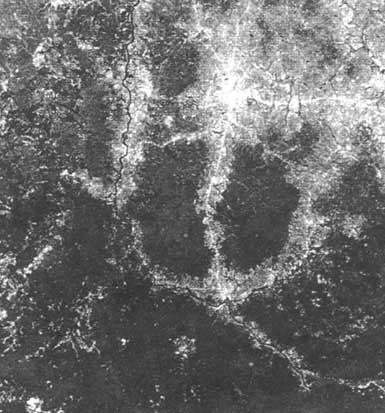
Satellite imagery used in forestry generally comes from one of two satellite sources: Landsat (United States National Aeronautics and Space Administration) or SPOT (French satellite system). SPOT panchromatic imagery has a higher resolution but Landsat Thematic Mapper imagery provides more wavelengths of data. Satellite images are well suited to the classification of digital data into broad land cover classes and to the detection of changes in forest area or condition over time. They are not replacements for aerial photographs because their resolution is so much lower. Furthermore, the analysis of satellite imagery is a relatively specialized field, requiring a considerable investment in computer hardware and software and specially trained personnel. Like aerial photograph interpretation, it requires field verification.
Satellite images are well suited for detecting changes in forest area or condition over time
Geographic information systems
Computerized geographic information systems (GIS) represent an important development in information technology. A GIS is a computer hardware and software system designed to organize, store, retrieve, analyse, display and publish spatially referenced data. Although most GIS are capable of producing high-quality maps, their capabilities go far beyond this. The key to the importance of GIS, in fact, lies in their advanced analytical capabilities which enable managers to analyse complex situations rapidly, sometimes in entirely new ways (Berry, 1986). As an example, with GIS it is possible to "overlay" map layers representing timber classes, soil types, and topography so that a map can be produced which shows all areas of mature timber on fragile soils where the ground slope exceeds 40 percent. Because this "derived" map layer resides in the computer system, its area can be quickly computed. Inventory information can then be combined with the map data to estimate the reduction in the allowable annual harvest volume that would result if this area were removed from the allowable cut base.
GIS represents a tremendously powerful tool that has the potential to enhance greatly the capabilities of forestry organizations in tactical planning. To achieve this potential, the organization must be prepared to commit substantial resources in terms of both personnel and funding.
GIS will be useful for forestry analysis, only if the foresters use it. This means that all professional forestry staff (including top-level managers) should receive at least "awareness" training in GIS, and those who will use the system to extract information and carry out analyses should receive additional, more technical training. Sufficient hardware must also be provided so that each professional who will be using the GIS has convenient access to it. In most cases, the GIS will reside on a high-performance computer workstation, and individual users wills connect to it through a network accessed ' from their desktop personal computers.
Global positioning systems
A recent development in information technology that has managed to capture the imagination of foresters around world is the Navstar Global Positioning System (GPS), an all-weather navigation and position-fixing system based on radio signals transmitted by satellites launched and maintained by the United States Department of Defense. This network comprises a fleet of satellites which, together, provide position-fixing capabilities almost anywhere on earth, day or night. One important application of GPS is to provide data for GIS and, in fact, the system makes it possible to collect certain kinds of spatially referenced data that it would otherwise probably not be economically feasible to obtain.
Like all such technologies, acquiring skill in the use of GPS requires practice, and organizations which adopt the system must recognize that data accuracy will be relatively low at first but will improve over time as field crews become proficient both with the equipment and with the procedures for its correct use.
As important as they are for strategic and tactical planning, advances in information technology are also changing the way forestry organizations manage their day-today operations. As with planning technologies, information systems for operational management and control are of many different types and they are used in different ways by different organizations. Some of the more common information systems currently in use or under development include the following:
Electronic data recorders
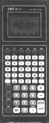
Electronic data recorders (EDRs) are basically hand-held computers which have been developed for recording field electronically. Many are available with software written specifically to enable the collection and-preliminary analysis of forestry inventory data. Those used in forestry must be rugged so that they can withstand exposure to rain, cold and hot temperatures and rough handling. Besides a keypad, screen and memory for recording and storing data. EDRs must generally have some way (typically a serial port) for transferring data to a computer for incorporation into the organization's permanent database (which might, for example, be a GIS).
On-board computers
With the advent of timber processors and cut-to-length harvesting machines, it is becoming more common for such equipment to include on-board computers which can help decide on the optimal crosscutting strategy for individual stems. In the future, it is likely that on-board computers will be connected through radio transmission links to a central computer at the mill. This will permit crosscutting to satisfy order requirements, rather than simply considering each stem independently, and will also permit crosscutting rules to be changed at intervals during the day as new information on product orders becomes available.
Manual crosscutting by computer
In places where trees are large and the topography is rugged, such as the Pacific Northwest of the United States, manual felling and crosscutting still predominates. Even here, through hand-held computers, technology is now available that permits crosscutting decisions to be rapidly optimized (Garland, Sessions and Olsen, 1989). Such practices can routinely increase log values by 10 to 15 percent as compared with conventional crosscutting methods.
Truck-mounted GPS
Some forestry organizations are experimenting with the use of GPS to help improve the efficiency of truck scheduling and routing. Trucks equipped with both GPS and automatic radio-transmitting equipment to send the GPS data to a central receiving point make it possible for transportation equipment to be tracked in real time on a display map of the operating area. The feasibility of such systems depends to a considerable: extent on the availability of reliable radio communications. Such systems have perhaps been implemented most extensively in the Nordic countries.
Electronic data recorders are hand-held computers used to record field data electronically
Real time data transmissions
In an effort to reduce log inventories and improve order responsiveness, some forestry organizations are experimenting with the transmission of production and transport data from the production site to the mill and the transmission of order requirements from the mill to the production site. This is usually done by radio at intervals during the day. The intention eventually is to use automated transmission systems which would require little or no human intervention. Theoretically, it should be possible to maintain almost no log inventory at the mill, and to harvest and crosscut trees in response to specific orders. This will require more reliable radio transmission capabilities than are currently available in most countries.
The management of information technologies is now firmly and irrevocably an essential part of forest management. Forest managers must understand at least the strategic and tactical implications of these emerging technologies and must be ready to make fundamental changes in their organizations in order to take advantage of the potential that can be provided by timely, accurate information. Nearly all of these technologies will require substantial new investments, not only in the technologies themselves but also in the training of personnel and the acquisition and verification of data. A strong and active commitment of managers at the highest levels in the organization is therefore essential if the new technologies are to be implemented to the organization's advantage.
Berry, J. K. 1986. GIS: Learning computer-assisted map analysis. J. Forest., 84(10): 3943.
Bobbe, T., Reed, D. B. & Schramek, J. 1993. Georeferenced airborne video imagery. J. Forest., 90(12) 16-21.
Brice, C. E. 1992 Glossary of GPS terms. J. Forest., 91(8) 10- 14.
Dams, R. V. & Larsson, M. 1992. New fuel to fire the GIS digital orthoimagery In Proc. Joint FAO/ECE/ILO Committee Seminar on The Use of Information Systems in Forestry, 14-18 September 1992, Garpenberg, Sweden Geneva, ECE/FAO Agriculture and Timber Division.
Davis, L.S. & Johnson, K. N. 1987. Forest-management, 3rd ed. New York, McGraw-Hill.
Dykstra, D. P. 1984. Mathematical programming for natural resource management. New York. McGraw-Hill
FAO/ECE/ILO. 1992. Proc. Joint FAO/ECE/ILO Committee Seminar on The Use of Information Systems in Forestry, 14-18 September 1992, Garpenberg, Sweden. Geneva ECE/FAO Agriculture and Timber Division.
Garland, J., Sessions, J. & Olsen, E. D. 1989. Manufacturing logs with computer-aided bucking at the stump. For. Prod J., 39(3): 6266.
Graham, L. A. 1993. Airborne video for near-real-time vegetation mapping. J. Forest., 90(12) 1621
Greer, J. D. 1993 The view from above: an overview of GPS and remote sensing options J. Forest., 91(8): 10-14.
Hellström, C. 1993. GPS/GIS forestry applications in Sweden - experiences and possibilities. Skog Forsk Results No. 5. 4 pp.
Kruczynski, L. R. & Jasumback, A. 1993. Forestry management applications: forest service experiences with GPS. J. Forest., 91(8): 10-14.
Lachowski, H., Maus, P. & Platt, B. 1992. Integrating remote sensing with GIS. J. Forest., 90(12): 16-21.
Lance, K. 1993. Bringing technology down to earth: a GPS consumer's guide. J. Forest., 91(8): 10-14.
Sumpter, C. 1993. Property surveys using GPS. J. Forest., 90(12): 16-21.
USDA Forest Service. 1991. GIS evaluation report. Computer Sciences and Telecommunications. Washington, DC
USDA Forest Service. 1994 National GIS guidebook. Information Systems and Technology. Washington, DC
![]()
![]()
![]()