![]()
![]()
![]()
T. E. Burk, P. J. Cameron, S. D. Lime and S. Lane
Reliable, up-to-date data on resource conditions and equipment and personnel availability is crucial for forest fire prevention and suppression planning. This article describes a system that uses the Internet to distribute such data to field professionals as well as the general public. The system described was intensively utilized during the spring 1996 fire season in the state of Minnesota, United States.
Thomas E. Burk is Professor, Department of Forest Resources, University of Minnesota.
Paul J. Cameron is Research Assistant and Laboratory Coordinator, Department of Forest Resources, University of Minnesota.
Stephen D. Lime and Steven Lane are Area Foresters, Division of Forestry, Minnesota Department of Natural Resources.
The Internet has become a pervasive mode of communicating information. Beginning as a convenient way for United States university researchers to share ideas, use of the Internet has now permeated nearly all aspects of society and commerce. A principal force behind the Internet's rapid and widespread growth has been the World Wide Web (WWW), a communication protocol and software specification that allows data of many types to be delivered from server computers to easy-to-use client front-ends, mainly running on personal computers. Multiple data formats are handled by creating WWW documents using the Hyper Text Markup Language (HTML). HTML documents residing on a server are accessed and displayed using client computer browser software. The power and flexibility of the WWW continue to grow at a phenomenal rate, fuelled by the ever-increasing marketplace for its use.
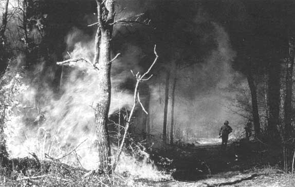
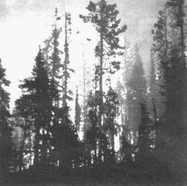
A ground-level view of a forest fire in Minnesota (1996)
Many forestry professionals have realized the power of the WWW and are using it to communicate among themselves and with the public (Burk, 1995). As of November 1996, the Virtual Forestry Library (http://www.metla.fi/info/vlib/Forestry.html) listed several hundred WWW-based resources of direct relevance to forestry and forestry practice. At present, much of this is static information, text, graphics, etc., that could also be provided via print media. Still, the WWW offers several advantages over print media, including a more rapid production turnaround and greater flexibility (e.g. low-cost use of colour) as well as a convenient means of keeping documents current. The hyper text basis of HTML, which allows a seamless connection from part of one WWW document to part of any other WWW document, lends itself to creating very information-rich records.
A less common application of the WWW, but one with far greater power, is the distribution of dynamic data. Here, documents are custom-generated based on the users' specific interests at any particular moment. This use of the WWW requires a marriage of WWW client browsers to other software tools that manage a database and generate browser-ready reports. A simple example of distributing dynamic data is a retailer placing their sales catalogue on the WWW and allowing customers to search the catalogue using keywords that describe products of interest. The ForNet project (http://www.gis.umn.edu/fornet) at the University of Minnesota's College of Natural Resources is exploring use of the WWW for a dynamic distribution of forest management data. Several prototype examples have been developed as part of ForNet. This paper describes one of those examples, a forest fire information system which reports on the status of fires and fire conditions statewide in Minnesota. The system also allows managers to track equipment resources under their direct control as well as equipment potentially available for their utilization.
Forest land management organizations devote significant resources to forest fire prevention and suppression efforts. Reliable, up-to-date information is critical if prevention and suppression tasks are to be carried out effectively and efficiently. Information concerning both the condition of the land resource as well as the status of equipment and personnel for dealing with fire situations is needed. For organizations with a large land base and distributed personnel it is important that relevant information be continually shared among parts of the organization so that efforts can be coordinated. Public agencies with geographically wide responsibilities must also communicate relevant information, such as burning permit status, to the general public. At the peak of the fire season, these communication needs have often been met using radio, telephone or fax. The time-sensitive nature of forest fire planning information makes the WWW a logical substitute for these other communication media.
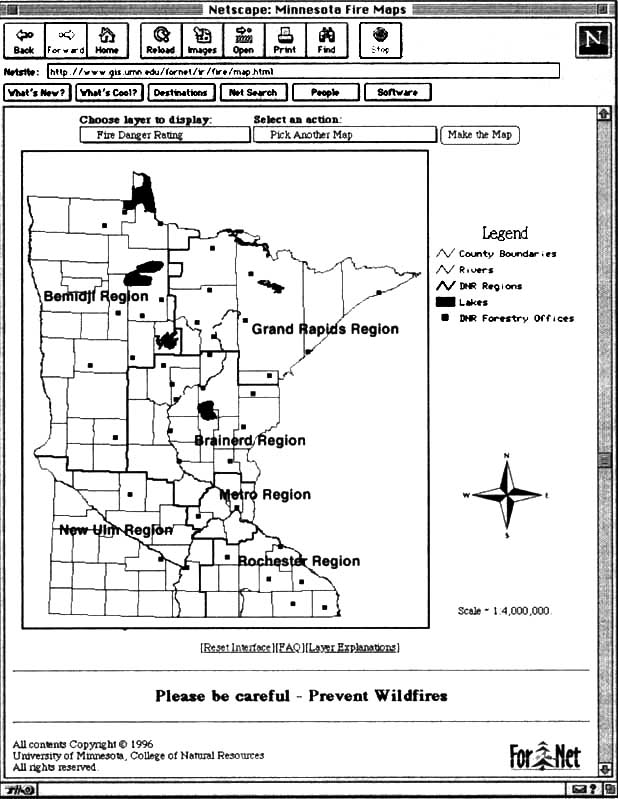
FIGURE 1: WWW interface for the forest fire mapping application
Computers have long played a major role in forest fire prevention and suppression activities, including the study of vegetation and weather conditions leading to successful prescribed fires (Reinhardt, Wright and Jackson, 1989) and computer models for studying the behaviour of fires in certain fuel conditions (Andrews, 1986). It is only logical that forestry professionals again turn to the computer to assist them in other aspects of fire prevention and suppression problems. Towards this end, a source of general information on rural and landscape fires has had a WWW presence for several years (see http://www.anu.edu.au/Forestry/fire/firenet.html).
This article first describes the fire mapping and equipment tracking components of the ForNet forest fire information system. The authors then provide some background on the software tools that are the bases for these applications and discuss the role of forestry field professionals in the development and maintenance of the system. The article concludes by discussing the types of investment required to put such a system in place and also considers the future of this and related efforts.
Readers who have access to the WWW can see the applications described below by going to http://www.gis.umn.edu/fornet/ir/fire, where the complete Minnesota Forest Fire Information System is presented.
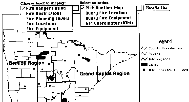
The fire mapping application is a WWW browser-based interface to a geographic information system (GIS) on fires and fire-related intelligence for the State of Minnesota. A user's entry into the system begins with a map of the state (Figure 1). In addition to major water bodies and county boundaries, this base map delineates the working regions of the Minnesota Department of Natural Resources' Division of Forestry (DNR-Forestry), the land management agency with the primary responsibility for forest fire prevention and suppression in Minnesota. The "display" and "action" pull-down menus associated with the map (Figure 2) allow a user to query the GIS for additional map information or specific attributes associated with map elements. For example, choosing the action "Pick Another Map" generates a map of the currently selected display, while choosing "Get Coordinates" retrieves the location of any point clicked on the current map.
Three GIS layers pertaining to broad-based fire information can be chosen for display: fire danger rating, fire restrictions and fire planning levels. The fire danger rating is an index of overall fire danger taking into account factors such as probability of ignition, likelihood of fire spread and potential fire intensity. Fire restriction identifies the status for issuing burning permits, with a higher level of restriction indicating (the possibility of) increasing fire intensity or exhaustion of resources and personnel. Fire planning levels indicate general equipment and staffing needs or availability. The choice of any of these layers produces an up-to-date, multicoloured map providing the data at the detail of a county. The utility of the data lies in communicating within the agency across management subunits and with news agencies as well as directly with the public.
Current fire locations can be viewed by selecting the "Fire Locations" display. Fires are colour-coded by areal extent. With fire locations displayed, the user can query the location (click on it with a mouse) and obtain additional data concerning the fire, for example the precise location, the number of hectares affected, the damage done, etc.
Choosing the display "Fire Equipment" produces a map of the current location of major fire-fighting resources such as helicopters, air tankers, special strike teams, etc. Querying a particular location provides additional details about the resource, including its capability, availability, and exact location.
FIGURE 2: Contents of the pull-down menus for the forest fire mapping application
The utility of these latter two types of information lies in communicating and coordinating within the DNR-Forestry organization itself.
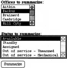
Tracking the location and availability of fire-fighting resources within a land management organization is critical. During the peak of a fire season, such information may change almost continually. Outdated information is of little or negative value in fire-fighting planning. A prototype application addressing the organization and delivery of fire-fighting resource information was developed for one DNR-Forestry Region within the State of Minnesota for use during the spring 1996 fire season. The user of the application is presented with a very simple two-menu interface which provides access to a central server-residing database (Figure 3A). Selecting an office or set of offices in combination with a status type produces a report detailing equipment type, owner and current location for all pieces of equipment that meet the selection criteria (Figure 3B). A map with major roads delineated can also be generated to facilitate the planning of equipment acquisitions.
Two general-purpose software tools provide the capability built into the fire mapping and equipment tracking applications. MapServer software is used by the fire mapping application to set up and process queries to and generate displays of results from the fire intelligence spatial database. MapServer also provides the capability to retrieve attribute data associated with map elements. Sequel software is used for querying the database and generating displays of query results for the equipment tracking application.
Currently, both MapServer and Sequel are running on a College of Natural Resources (University of Minnesota) server computer. Data for the applications also reside on that server, including a Sybase database used in conjunction with Sequel. DNR-Forestry personnel access the applications from their own computers using standard WWW client browsers.
MapServer is a Common Gateway Interface (CGI) program, written in C, that allows use of GIS data from a WWW client browser. CGI programs (Schatz and Hardin, 1994) are a feature of the WWW that greatly extend the capability of simple HTML documents by allowing interaction with data and/or software applications that exist on a WWW server computer. MapServer works directly with shapefiles, an alternative GIS data storage format available in ArcView (ESRI, 1995), so that any ArcInfo-based GIS data can be served over the WWW. MapServer is fully self-contained; it does not rely on any other server software to process data or create reports. Among MapServer's features are: scale-dependent feature drawing and labelling; customizable colour, symbol and scaling values; feature-based access to attribute data; automatic legend generation; and support for tiled data. To apply MapServer to a particular problem requires creating two types of template files, one that specifies what the user interface looks like in the WWW browser and one that describes how a particular map should be put together from the database of shapefiles. The former file would contain the HTML, including form elements, for obtaining Input information: from the user. A great deal of flexibility is afforded in processing and displaying GIS data. MapServer has been successfully applied to six different problems as part of the ForNet project (see http://www.gis.umn.edu/fornet/docs/MapServer).
|
These menus will allow you to summarize the information about firefighting equipment in the Brainerd Region. Leaving a menu blank is equivalent to selecting everything in that menu. We also have maps of the individual areas online. |
WWW client browser contents to the application used for tracking fire- fighting equipment: the results of a query
|
Fire Resources Database Summary | ||||
|
Results # |
Owner |
Resources |
Status |
Location |
|
1 |
Hill City |
Type 6 Engine A |
Available |
Off Unit |
|
2 |
Hill City |
Type 6 Engine B |
Available |
Off Unit |
|
3 |
Hill City |
Type 6 Engine C |
Available |
Off Unit |
|
4 |
Hill City |
Type 6 Engine D |
Available |
Off Unit |
|
5 |
Hill City |
Type 6 Engine E |
Available |
Off Unit |
|
6 |
Hill City |
Type 6 Engine F |
Available |
Sandy lake |
|
7 |
Hill City |
Type 6 Engine G |
Available |
Off Unit |
|
8 |
Hill City |
Type 4 Engine |
Available |
Off Unit |
|
9 |
Hill City |
Helitac |
Available |
Off Unit |
|
10 |
Hill City |
Crew Boss |
Available |
Off Unit |
|
11 |
Backus |
Division Supervisor |
Available |
Off Unit |
|
12 |
Backus |
Type 6 Engine A |
Available |
Backus |
|
13 |
Backus |
Type 6 Engine B |
Available |
Backus |
|
14 |
Backus |
Type 4 Engine |
Available |
Backus |
|
15 |
Backus |
Dozer Type 4 with Plow |
Available |
Backus |
|
16 |
Backus |
Type 6 Engine Utility C |
Available |
Nimrod |
|
17 |
Backus |
Type 6 Engine D |
Available |
Nimrod |
|
18 |
Backus |
Type 6 Engine E |
Available |
Nimrod |
|
19 |
Backus |
Dozer Type 4 |
Available |
Nimrod |
|
20 |
Backus |
J-5 Bombardier |
Available |
Nimrod |
|
21 |
Backus |
6x6 1000 Gallon Tank |
Available |
Nimrod |
Sequel is an interface between the WWW and structured query language (SQL) databases. It differs from similar interfaces in its emphasis on flexibly representing query results. Currently, Sequel works only wide Sybase databases-. To apply Sequel to a particular problem requires writing an HTML form with specially constructed variable names and a template file that identifies which database tables will be queried and how the output from the query should be formatted. The specially constructed variable names are used by Sequel to generate SQL commands, with the results returned to the WWW client browser according to the HTML format outlined in the template file. More information on and examples of using Sequel can be found at http://www.gis.umn.edu/fornet/docs/sequel.html
Field foresters from DNR-Forestry were active participants in the design and implementation of the forest fire information system. The initial problem addressed was the application of current technology to assist field staff in responding to the needs of initial attack forces during high fire activity days. During the peak of the fire season, field offices will often run out of initial attack forces, requiring the prioritization of fires to be responded to or requests for assistance from neighbouring offices. Shortages in resource must be anticipated as far in advance of their occurrence as is possible. Access to current, high-quality fire information is crucial in these instances. Information concerning equipment and personnel resources are both required. Based on earlier work of the ForNet project (Burk and Lime, 1995), DNR-Forestry approached ForNet, seeking an Internet-based solution. It was felt that the Internet would offer a feasible, low-cost approach. Field offices already possessed personal computers and WWW capability could be added with little effort.
Figure 4 WWW client browser contorts for updating the fire-fighting equipment database
|
Resource Update for Aitkin Area | ||||
|
Which resource would you like to update? |
J-5 Bombardier B545 | |||
|
What action would you like to perform? |
Assigned | |||
|
Please enter a location for this item. |
McGrath | |||
|
Hit this button to submit your update. |
Submit update | |||
|
Results # |
Owner |
Resources |
Status |
Location |
|
1 |
Aitkin |
Type 6 E640 |
Available |
Off Unit |
|
2 |
Aitkin |
Type 6 E641 |
Assigned |
Off Unit |
|
3 |
Aitkin |
Type 6 E642 |
Available |
Aitkin |
|
4 |
Aitkin |
Type 6 E643 |
Available |
McGrath |
|
5 |
Aitkin |
Type 6 E644 |
Available |
McGrath |
|
6 |
Aitkin |
1 ton 4x4 Transport |
Available |
Aitkin |
|
7 |
Aitkin |
J-5 Bombardier B545 |
Out of service - Mechanical |
Aitkin |
|
8 |
Aitkin |
J-5 Bombardier B546 |
Available |
McGrath |
|
9 |
Aitkin |
Type 4 E447 |
Available |
Aitkin |
|
10 |
Aitkin |
J-7 Bombardier B748 |
Available |
Aitkin |
|
11 |
Aitkin |
ASV - Possi Track |
Out of service - Unmanned |
Aitkin |
|
12 |
Aitkin |
3 Person MCC Crew |
Out of service - Unmanned |
Off Unit |
|
13 |
Aitkin |
Helitac |
Available |
Aitkin |
|
14 |
Aitkin |
Communication Leader |
Available |
McGrath |
|
15 |
Aitkin |
Extended Attack I.C. |
Available |
Off Unit |
|
16 |
Aitkin |
Staging Manager |
Out of service - Unmanned |
Off Unit |
|
17 |
Aitkin |
Division Supervisor |
Out of service - Unmanned |
Off Unit |
Two DNR-Forestry staff acted as liaisons-between- a committee of field foresters-familiar with fire-fighting information needs and ForNet staff during the application development process. Several iterations of the equipment tracking database were produced until a general agreement was reached on its form, content and format for delivery. The success of the system can be measured by its level of use. During the peak of the spring 1996 fire season, the database was accessed scores of times by field personnel on an almost daily basis.
The ForNet project focuses on delivering spatial data over the Internet. Based on DNR-Forestry interest in sharing forest fire information, discussions began on distributing map-based fire information to field offices and the public. Maps of fire danger rating and related indices had previously been assembled and faxed daily to field offices and news sources that requested them. It seemed clear that the Internet offered a better solution. The forest fire mapping system evolved from those discussions, initially focusing on simple maps that were updated as needed to create a complete map and query system where fire and large fire-fighting equipment status data could be updated continually.
A key to the effectiveness of the forest fire information system is the timeliness of the data it provides. Although all the data for the system resides on server computers maintained at a central site, the most appropriate maintainers of the data are the field foresters themselves. This necessitated building capability for off-site updating into the forest fire information system.
An updating system for the equipment tracking database was built using the same WWW tools used in implementing querying of the database itself (Figure 4). Access to this system is via a password, for obvious reasons. Each area field office designates a staff member responsible for keeping track of equipment and location and updating the on-line database accordingly. Simple pull-down menus ease the process of updating. Once a change is made, all users of the database have access to up-to-date data. This same updating system allows field personnel to upload HTML and graphics files to the central server to share additional situation and status information with their colleagues. Mechanically, this is easy to do, as it can be accomplished from a WWW browser; practically, it can be difficult as it requires additional knowledge of the structure of the WWW site. A simple bulletin board system for general announcement posting was also implemented at the request of DNR-Forestry users.
Updating of the fire mapping system is also completed in the field. During the spring 1996 fire season this was done by a staff member of DNR-Forestry. Each morning the necessary data were collated from regional office field personnel. An ArcView database was updated and shapefiles representing the data exported and transferred via file transfer protocol to the central WWW server. Attribute data associated with fire and equipment layers were uploaded at the same time. Users of the fire mapping system have WWW access to this updated information immediately. During the peak of the fire season components of the mapping system were updated in this manner several times per day.
Flames reach the tree crowns in a forest five in Minnesota (1996)
The successful implementation of the forest fire information system is due to the presence of a real problem and the enthusiastic involvement of real users throughout the whole development process. Although fire activity level was low for much of the spring 1995 fire season, users were impressed with the utility of the system. Significant advantages were recognized in terms of time-use efficiency, effectiveness in public communication and degree of preparedness. The continued success of the system obviously requires that the system become an everyday part of the field forester's job. The "early adopters" involved in implementation have been actively evangelizing the system's utility to their colleagues and DNR-Forestry administrators who control funding. Their success, or lack of it, will determine the long-term usefulness of the system.
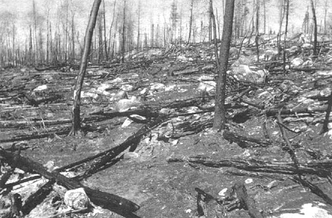
The aftermath of a forest fire in Minnesota (1996)
At present, the server computers that implement the fire mapping and equipment tracking applications, as well as the data which support are located at the College of Natural Resources (University of Minnesota). DNR-Forestry will soon be putting the necessary hardware and software on-line to take over this role of serving. At that point the software tools will be turned over and maintenance will become the full responsibility of DNR-Forestry staff. The technology transfer aspect of the project will be complete.
The ForNet software tools that enabled implementation of the forest fires information system will be made freely available. Basis WWW server software can also be obtained at little or no cost. For an organization to implement a similar system would require a server computer (80686 class) and the presence of a wide-area network. The wide-area network itself represents a very large investment, one not solely justifiable on a single information system. Sybase database software and usage licences would constitute the greatest server-side software cost field sites would need to be connected to the network (some DNR-Forestry sites use high-speed modems and Internet service providers) and possess computers powerful enough to run browser software (80486 class or better) effectively. Browser software constitutes a moderate investment. The power of the server computer(s) and the size of the network would be scaled to the size of the client base to be served. Personnel resources would be needed to set up and maintain the system. An information technologist with WWW and GIS experience and a subject matter expert would each invest one to three months' time in setting the system up. Maintenance could eventually become part of general server support. Data served in the forest fire information system come from simple maps maintained in a GIS and from manual tracking of equipment locations and status; they represent little incremental cost increase. For other information systems, data may constitute a significant new investment.
ForNet project staff are pursuing one additional component of the forest fire information system. This component will provide flexible Internet delivery of regionwide vegetation indices computed from Advanced Very High Resolution Radiometer (AVHRR) data. Users will be able to access the most recent data and compare it with historical averages from similar dates or create animations showing the temporal development of vegetation in their area. Recent research (Burgan, Hartford and Eidenshink, 1996) has shown that such data are useful for predicting fuel moisture conditions in forested cover as well as the associated fire danger level. The
high temporal- and medium spatial resolution of AVHRR data make them ideal for statewide fire planning applications. An early prototype of this work can be seen at http://www.gis.umn.edu/~pcameron/avhrr/avhrr.html
The forest fire information system is one simple example of how the Internet and well-designed software tools can be applied to deliver dynamic data to a dispersed user community. Related forest management problems that could be effectively addressed in a similar manner include providing inventory data and analysis tools, timber sale information, forest use permit availability, forest pest updates and status information on the implementation of forest plans, to name just a few. As with the forest fire information system, a potential for improved communication with the public will be a driving force behind much of this. Wide-area networks, including the Internet, will become an increasingly common component of organizations' and countries' information infrastructures. Use of technologies built on the WWW (or its successor) to distribute data will become standard practice in forestry.
Andrews, P. L. 1986. BEHAVE: Fire behaviour prediction and fuel modeling system - BURN subsystem, Part 1. Gen. Tech. Rep. INT-194. Washington, DC, USDA Forest Service. 130 pp.
Burgan, R. E., Hartford, R. A. & Eidenshink, J. C. 1996. Using NDVI to assess departure from average greenness and its relation to fire business. Gen. Tech. Rep. INT-333. Washington, DC, USDA Forest Service. 8 PP
Burk, T. E. 1995. Forestry on the Internet: an introduction. J. Forest., 93: 6-7, 50-54.
Burk, T. E. & Lime, S. D. 1995. Distributing tactical forest planning information via the Internet. Proc. IUFRO Workshop on Internet Applications and Electronic information Resources in Forestry and Environmental Sciences. (available at http://dendron.fr.umo.edu/joen/main.html)
ESRI. 1995. ArcView shapefile technical description. ESRI White Paper Series September 1995. 14 pp. (available at http:www.gis.umn.edu/fornet/docs/MapServer/av_shape.pdf)
Reinhardt, E., Wright, A. H. & Jackson, D. H. 1989. An advisory expert system for designing fire prescriptions. Ecol. Modelling, 46: 121-133.
Schatz, B. R. & Hardin, J. S. 1994. NCSA Mosaic and the World Wide Web: Global hypermedia protocols for the Internet. Science, 265: 895901.
![]()
![]()
![]()