![]()
![]()
![]()
J. Fairhead and M. Leach
This article suggests that the extent of deforestation that has occurred in West Africa during the twentieth century is currently being exaggerated. It presents key findings of detailed research into vegetation change over the past century in Côte d'Ivoire, Sierra Leone, Liberia, Ghana, Togo and Benin.
James Fairhead is with the International Development Centre Of the University of Oxford, UK Melissa Leach is with the Institute of Development Studies, University of Sussex, Brighton, UK.
Many estimates of West African forest cover change have been made during the twentieth century. In this article, which very briefly summarizes a more extended and fully referenced work (Fairhead and Leach, in press), we argue that recent estimates have hugely exaggerated the extent of forest decline since 1900. Forest loss during this period may be only one-third of the figures currently circulating in international scientific works. While analyses of present vegetation cover and of change over the last decade might be increasingly precise, making use of multiple data sources and remote sensing (FAO, 1996; Sayer, Harcourt and Collins, 1992), the same cannot be said for the assessments of past forest cover with which these analyses are compared. We suggest that, when investigating past cover, forest loss assessments have either used historical sources uncritically or have not used historical data at all. Indeed, most authors find it acceptable to make suppositions concerning the nature and extent of earlier vegetation or to make uncritical reference to other studies that do this. In particular, it has become acceptable to deduce the nature and extent of past forest cover and the time scale of its loss, from observations of present vegetation, coupled with several presumptions: i) that everywhere that forest could exist today (under given climatic and soil conditions), it originally did exist in a pristine form until it was degraded to today's state or lost completely to savannah; that this loss was principally caused by people's land use activities; iii) that inhabitation of forest land is relatively recent (generally since around 1900); and iv) that earlier farming and land management were either insignificant or benign for the forest.
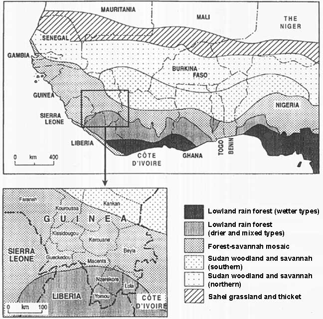
Analyses of forest cover change are beset by problems of definition, and much forest can be lost or gained in the translation between definitions. One aim of our analysis has been to identity instances in which academics or policy-makers have been misled (or have misled others) by such "definitional deforestation" (or afforestation). Nevertheless, in this study, following Hall (1987), forest is generally characterized as "vegetation dominated by trees, without a grassy or weedy understorey, and which has not recently been farmed'. Thus defined, forest includes logged-over areas but is readily distinguishable from savannahs. We also circumscribe our concern to forests characteristic of West Africa's humid and semi-humid zones. This general definition is broadly in keeping with analyses incorporated into FAO's 1980 Forest Resources Assessment (FAO, 1981), but not with its 1990 assessment (FAO. 1993). The latter incorporates as "moist forest" very large areas which are not conventionally defined as such in West Africa, rendering the figures totally incomparable with earlier sources. Instead, for 1990 data we draw principally on other recent assessments synthesized by the World Conservation Monitoring Centre (Sayer, Harcourt and Collins. 1992).
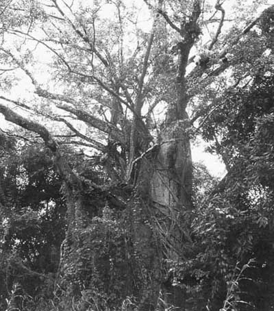
We have attempted to seek more precision concerning vegetation cover at different dates by using early landscape descriptions, air photographs and maps and oral evidence. Our aim has been to shed light on forest loss and forest ecology from historical sources rather than to interpret forest history from ecological sources. This endeavour was prompted by our earlier study in Guinea (Fairhead and Leach, 1996) which revealed a striking contrast between the assessments of vegetation change in scientific and policy documents and historical evidence. In Guinea's Kissidougou prefecture, during the past century - the period in which today's analysts consider there to have been the most forest destruction forest areas had actually increased at the expense of savannah.
Historical and social anthropological research showed that the same observations that scientists and policy-makers had been taking to indicate deforestation were properly interpreted as indicating anthropogenically assisted forest establishment. In particular, forest islands located in savannah were found to owe their existence to inhabitants who had encouraged them to form around savannah settlements. Forest patches were therefore not the relics of a larger past forest, as they had been taken to be. Our research also showed how farmers had established forest fallow (farm bush) in what had earlier been grassy savannahs and that forest thicket fallows, therefore, were not degraded forest as had been thought. Furthermore, we found how oil-palms were being established in savannahs, rather than being relics left after the conversion of forest to savannah.
Drawing on these insights and historical works we have examined critically the evidence for forest loss during the twentieth century in several West African countries. Here we briefly review our findings concerning forest cover change in Côte d'Ivoire as a way of exemplifying the problems in forest cover data and then, even more briefly, summarize our findings from Sierra Leone, Liberia, Ghana and Benin.
Following FAO's 1980 Forest Resources Assessment (FAO, 1981), Côte d'Ivoire acquired the reputation of having the highest rate of deforestation in the tropics. Numerous articles appeared between 1978 and 1984, using the same data-summarized in Table 1 - and drawing the same conclusions (Monnier, 1981; Bertrand, 1983; Arnaud and Sournia, 1978; Myers, 1980). These works continue to influence more recent statements concerning Ivorian forest cover change during the present century (Parren and de Graaf, 1995; Sayer, Harcourt and Collins, 1992; Myers 1994).
TABLE 1. Dense humid forest cover change in Côte d'Ivoire
|
Date |
Area |
|
c.1900 |
14.5 |
|
End 1955 |
11.8 |
|
End 1965 |
9.0 |
|
End 1973 |
6.2 |
|
End 1980 |
4.0 |
|
End 19901 |
2.7 |
|
Total loss since 1900 |
11.8 |
1 Figure from Sayer. Harcourt and Collins (1992).
Source: FAO (1981)
The data for forest area in 1955 and 1965 were produced following a major evaluation of national timber potential by the Centre technique forestier tropical (CTFT, 1966; Lanly, 1969). The data for 1980 were based on the 1966 analysis but updated in the light of agricultural land use statistics. FAO (1981) supplies no evidence for the figure for 1900, it being the presumed area of the "forest zone", considered then to be more or less intact by the authors. Yet, neither the figure for 1900 nor those produced for 1955, 1965 and 1980 can be accepted. All subsequent analyses, therefore, have serious shortcomings in their assessment of past vegetation cover.
The 1966 study used the complete air photographic cover of Côte d'Ivoire for 19541956, as well as maps based on it, to calculate the area of the forest zone and the percentage of dense forest. The forest cover for 1966 was then calculated by comparing the proportion of land under forest in a sample of comparable 1956 and 1966 photos. It was concluded that the Ivorian forest cover had declined from 75 to 54 percent of a 13.1 million ha zone (Lanly, 1969). The study did not cover the extreme southwest, containing a higher proportion of forest than the rest of the country, but when this had been taken into account it was found that the forest cover had declined from 11.8 million ha in 1955 to 9 million ha in 1966.
There are, however, several reasons to doubt this figure. First, it seems hard to match the assertion that 75 percent of Côte d'Ivoire's forest zone was forest in 1955 with the observations made in the 1950s by both Aubreville and Mangenot, colonial foresters who knew Côte d'Ivoire well. Mangenot (1955, p. 6-7) suggested that, except for the southwest (about 2 million ha of forest), 'the reserves of the forest department represent almost the only intact specimens permitting today the study of the dense forest"... and that... "botanists often have some difficulty finding mature forest". Forest reserves (then 4.5 million ha) and forest in the southwest together represented only 6.5 million ha (40 percent of the supposed forest zone). Significantly, Aubreville himself estimated the area of Ivorian forest in 1950 to be only 7 million ha (Aubreville, 1959).
These authors were, it seems, distinguishing forest (whether it was logged-over or not) from other land uses. Mangenot (1955) was explicit about the illusions that the incautious observer might hold about Ivorian forest cover. He wrote:
"Seen from the summit of a hill, the landscape appears as a sea of trees... but when one.. travels over it following the tracks, one sees that over vast areas this actually corresponds with a corpse: the forest has been destroyed, with only a few large trees surviving, in whose shade are palm, coffee, cocoa, and cola plantains, and fields of manioc and yam. Each village is therefore at the centre of a zone not dewooded - large trees exist everywhere, and species cultivated are small trees, bushes and giant fortes, but deforested. High forest has been replaced by a mosaic of plantations, fields and bush fallows of small secondary woods."
That the CTFT-derived study exaggerated forest cover in 1955 is also suggested by several other sources. A second analysis of Ivorian forest cover was conducted almost simultaneously in 1967 (Guillaumet and Adjanohoun, 1971), from whose maps an estimate of forest cover could be made (although the authors themselves do not make such an area estimation). FAO (1981) and the United Nations Environment Programme [Ed. note: UNEP supported the 1980 Forest Resources Assessment] argue that the data from this study confirm the assessment in Lanly (1969) because, from its maps, it appears that a similar forest cover of approximately 8.8 million ha can be inferred. Yet the forest cover map in Guillaumet and Adjanohoun (1971) was actually drawn up from the 19541956 air photographs. Thus, rather than supporting the figure for 1966 in Lanly (1969), they undermine its figure for 1955 by suggesting that, in 1955, Côte d'Ivoire had approximately 8.8 million ha of forest.
A further reason to question FAO estimates of Ivorian deforestation derives from early colonial assessments of forest cover. While certain global forest analysts such as Breschin (1902) and Zon and Sparhawk (1923) assumed that the majority of the Ivorian forest zone was forest works which have misled certain modern authors - other early Ivorian specialists were not as naive. Meniaud (1930) was explicit. Under the heading "Statistical errors concerning the surface of 'Grand Forêt', the empty spaces in the interior of the extreme limits, and the reasons for these spaces," he suggested that: "The areas generally given in statistics as being occupied by the high forest are calculated according to the extreme limits, [that is] 11 million ha for the high forest of Côte d'Ivoire." By taking into account farmed and savannah areas in the forest zone, Meniaud calculates that "the primary forest, or that which is exploited only by the export timber industry" totalled only 8 million ha. Lower figures still were suggested by Chevalier (1909), who estimated only about 6 million ha, and by Gros (1910), who estimated between 7.2 and 7.8 million ha.
Consideration of the relationships between population and land use should also force us to question assertions of such high forest cover in 1955. To the west of the Bandama River, rice is a major crop and, in these regions, Chevalier (1909) calculated that population densities of only about seven people per km2 were sufficient to cultivate the entire territory under rotational bush fallowing with preferred fallow lengths of 12 to 15 years. As he said, "this is no exaggeration as, around villages of about 200 people, the forest is destroyed in a radius of between 5 and 7 km2. In 1955, three regions west of the Bandama River far exceeded such population densities: Daloa, 7.2/km2; Man, 10.6/km2; Gagnoa, 16.4/km2. The other two regions in the extreme southwest (Sassandra, 2.2/km2 and Tabou, 1.6/km2) had smaller populations, in keeping with descriptions of these areas which were the last forest reserves. Even allowing for the fact that Chevalier may have be exaggerating, these densities must have had a significant impact on forest cover. The east also had significant populations. In the Moronou region around 1900, there were at least 62 villages in an area of approximately 350000 ha (Ekanza, 1981). If each village only used land within a 4 km radius, the entire land area would be used. Similar village and population densities were found throughout the Aoussoukrou and the Ouellés regions of the forest zone between the Nzi and Comoe Rivers. Some areas would have been more and others less inhabited, leading to a vegetational mosaic of forests and fallows of different ages, merging with cola, palm, plantain and other plantations. However, it would be completely incorrect to consider this region to have been merely forest.
Furthermore, it is unlikely that forest cover in 1900 was much more than it was in 1955. Quite possibly it was less. Large parts of the forest existing in the mid-twentieth century may have been regrowth on land that had been under farming earlier. Many parts of the forest region were depopulated between 1900 and 1912 during the colonial wars between French forces and the Baoulé, Dan, Bete, Guro and Dida peoples. These peoples inhabit a huge region of the Ivorian forest zone. The effect of these wars on the Baoulé people who live on the forest margins is the best documented. Their population suffered an enormous decline from about 1.5 million in 1900 to 225000 in 1916 (Weiskel, 1980, p. 208-209), a huge loss when compared with official population figures for the entire country in 1921, which stood at 1.5 million, rising to only 2.5 million in 1955.
It was not only the Baoulé whose population fell. For example, a third of the population of Guiglo in the southwest fled into Liberia at the time of the French occupations, and the depressed populations in that part of the southwest did not increase between 1906 and 1972. The demographic shocks of the early colonial period were compounded by illnesses such as the 19181919 flu epidemic, and labour shortages engendered by the conscription of soldiers for the First World War forced labour for porterage and road-building. Farming areas thus abandoned would have succumbed to forest regrowth. While many observers noted huge forest losses near roadsides before independence, this is largely because the colonial regime had forced the Ivorian population to move to roadside villages and to abandon earlier settlements.
Each of these historical sources might be questioned, whether it be on the grounds of subjectivity, site-specificity or ambiguity of definitions. But, together, they certainly challenge present-day assertions that Côte d'Ivoire had 14.5 million ha of forest in 1900 and also seriously question the figure of 11.8 million ha for 1955.
One further question emerges concerning the area of the "forest zone". By 1909, Chevalier asserted that the limits of the Ivorian forest zone were known and the area was about 12 million ha, while others provided figures of between 11 million and 13 million ha. All modern analysts, however, suggest that the forest zone is significantly larger, at about 15.7 million ha.
This discrepancy can be explained partly by early authors' tendency to consider a strip of land (1 million ha) situated 20 km inland from the coast as lying outside the forest zone because it lacked forest owing to its lagoons, littoral savannahs or farmlands. More important, about 2 million ha on the northern margins of the forest zone, which carry savannah or a forest-savannah mosaic, are today considered to lie within the forest zone (as they "ought to carry forest"). Yet, in 1912 they were classified as being outside it. Early descriptions of the landscape clearly show that these areas did not carry extensive forest at the turn of the century. To say that they have been deforested since 1900, as many modern authors assert, is therefore erroneous.
Moreover, there is evidence that the area of the zone dominated by forest (and forest fallow) vegetation in Côte d'Ivoire has been increasing in recent centuries, not contracting, in relation to savannahs. Several oral accounts suggest that areas that are now well within the forest zone have been savannah in the recent past. Ekanza (1981), for example, could not believe his informants who suggested that the Moronou region, within the forest zone, was savannah around 300 years ago. But such a vegetation history is entirely consistent with recent ecological findings in Côte d'Ivoire. In the Baoulé savannahs, villagers say that "where one cultivates, the forest advances", and research on forest dynamics at the forest savannah boundary show just that (Spichiger and Blanc-Pamard, 1973), while elders affirmed to Adjanohoun (1964) that savannahs that once existed within the dense forest have today disappeared under forest. Rather than undergoing "savannization", "it is the forest which gains on the savannah, and this despite their action" (cf. also Spichiger and Lassailly, 1981).
Each of these issues forces one to question orthodox figures concerning deforestation since 1900. On the basis of the critique outlined above, we forward tentatively the alternative forest cover scenario elaborated in Table 2. This suggests that forest cover loss in Côte d'Ivoire during the present century may have been only half of what present authors consider it to have been.
Several authors have asserted that Sierra Leone has been deforested recently (Sayer, Harcourt and Collins, 1992; Nyerges, 1987). Myers (1980), for example, asserted that "as much as 5 million ha may still have featured little disturbed forest as recently as the end of the Second World War. It is a measure of the pervasive impact of human activities that the amount of primary moist forest now believed to remain is officially stated to be no more than 290000 ha." Yet such assertions are absurd, and with it the implied damning of African farmers, as several foresters at the turn of this century estimated forest cover even then to be only 100000 to 200000 ha, or approximately 1 percent of the land area (Unwin, 1909; Lane-Poole, 1911).Other modern assessments of forest cover change have been aware of this and date deforestation to a period between 1816 and 1860, when Sierra Leone became a timber exporter (Dorward and Payne, 1975; Millington, 1985). Such analysts treat supposed timber-led deforestation in Sierra Leone, with farmers settling in its wake, as a nineteenth century precursor to a phenomenon followed elsewhere in West Africa in the twentieth century. Yet neither analysis of the quality and quantity of timber exported nor of demographic movements can uphold this conclusion (Fairhead and Leach, 1997). Insufficient timber was exported to account for even 2 percent of the supposed area afflicted. In short, if there was little timber following timber felling, this is simply because there was little there in the first place, a conclusion fully supported by accounts of the coast and interior early in the nineteenth century. The whole question of "deforestation" in Sierra Leone needs to be radically rethought.
TABLE 2. Alternative forest cover change estimations for Côte d'Ivoire
|
Date |
Area1 |
Reconsideration (approx.) |
|
c.1900 |
14.5 |
7-8 |
|
End 1955 |
11.8 |
7-8.8 |
|
End 1965 |
9.0 |
6.3 |
|
End 1973 |
6.2 |
5.5 |
|
End 1980 |
4.0 |
|
|
End 19902 |
2.7 |
2.7 |
|
Total |
11.8 |
5.3-7.3 |
1
Data from FAO (1981)
2 Data from Sayer, Harcourt and Collins (1992).
Several authors assert that "within living memory", i.e. around 1900, the vast bulk of Liberia was covered with mature forests (Dorm-Adzobu, 1985), and such exaggerated claims of past cover have inflated deforestation estimates. Gornitz and NASA (1985) suggest that, around 1900, forest cover was 6.5 million ha, and Parren and de Graaf (1995) 7.3 million ha. But evidence from analysis of complete and ground-truthed air photographic cover in 1947 suggested: i) that there was a 3.5 million ha area of high forest and 1.9 million ha of broken bush (a forest of broken canopy partially cut for agriculture), adding up to an optimistic figure of 5.4 million ha of something that could reasonably be called forest; and ii) that forest areas had been increasing, not decreasing, over the first half of the century up to that date, as they: also had been over the previous 300 years as populations had declined (Mayer, 1951, p. 16). Indeed, Mayer's impression of Liberia, then, was of an "over-used, worn-out country of great antiquity". Some works have exaggerated deforestation by underestimating present forest cover. For example, FAO (1981) estimated Liberian high forest cover to have been 2 million ha (and to have been 1.7 million ha in 1985), whereas several more recent analyses based on air photographic and satellite imagery put the figure at 4.4 million to 4.8 million ha - forcing us to question the reasoning behind the FAO (1981) calculations. In short, rather than having lost between 4 million and 4.5 million ha of forest this century, with only 17 percent remaining (Gornitz and NASA, 1985), it is likely that Liberia may only have lost 1 million ha, with more than 44 percent remaining.
Many published works and national and international policy documents suggest that Ghana's forest zone (now defined as 8.6 million ha) was intact forest around 1880 (Fair, 1992; Ebregt, 1995; Parren and de Graaf, 1995). The fact that there are only about 1.7 million ha of forest today, that this exists only in reserves and that only about half of these are themselves in "reasonable condition" suggests a precipitous decline. As for Liberia and Côte d'Ivoire, that there has been a decline this century is undeniable, but has it been on this scale? Data from the early colonial period suggest that the area defined within the closed forest zone was about 7 million ha, of which no more than 5.5 million ha could have been forest. Furthermore, most of the forests early in the twentieth century were not in good condition. For example, when Thompson surveyed Ghana's forests in 1909, he found that "comparatively few tracts are covered with so-called primeval or virgin forest, the majority... consist of secondary irregular growth that has sprung up on areas previously cleared for farms" (Thompson, 1910, p. 147). Furthermore, as in Côte d'Ivoire, there is evidence that the area of the forest zone has increased in recent centuries. In the transition zone, many reserves that are closed forest today were savannah woodland early in the century, and oral accounts suggest that areas now well within the moist, semi-deciduous forest zone (e.g. 30 km south of Sunyani) had extensive grasslands around 1700. Furthermore, historical sources suggest that, owing to depopulation in many zones (linked perhaps to climatic rehumidification), the area of forest in 1900 may have been larger than it had been in 1600-1700.
Gornitz and NASA (1985) are not alone in suggesting that Benin's forest was intact up to 70 km inland from the coast at the turn of the century (approximately 1.1 million ha). Yet sources from the beginning of the century suggest otherwise. A 1:100000 map detailing dense vegetation exists for 1893 and suggests that only about 30 percent of this area was then covered in dense vegetation. When ground-truthed contemporaneously with the accounts of early botanists in the region, one finds that this dense vegetation was not forest, but palm grove. As Chevalier noted, "the palm covers all the land.... In some places, the uncultivated bush seems to dominate, but when one examines it closely, one finds that this bush covers land in fallow, and among the trees and bushes, live oil palms in close ranks" (Chevalier, 1912). Furthermore, Chevalier and, later, Aubreville describe how farmers established much of this palm grove in savannah. While those arguing for deforestation suggest that its relics remain in the occasional patch of forest that can be found, these forest islands are generally associated with sacred groves, and a good case can be made that most of these forests have either been established or enriched artificially and/or have grown on the abandoned sites of towns or villages where habitation has made the soils extra fertile. Equally, as in the other countries discussed, analysts who have seen species of trees characteristic of forest (e.g. Milicia excelsa, Antiaris toxicaria, Ceiba pentrandra) standing alone with tall straight boles have incorrectly deduced that these trees acquired their form when growing within a forest of which they are therefore a relic. Yet these (and many other) forest trees can acquire a forest form even when growing in isolation, and they are among those frequently encouraged by West African farmers for growing in fields. A debate has already raged over the extent to which Benin was deforested between the sixteenth and nineteenth centuries (Cayihor, 1986; Blanc-Pamard and Peltre, 1987), and assertions of massive forest loss over this period can be rejected.
TABLE 3. Suggested revisions to deforestation estimates since 1900
|
Country |
Orthodox figures |
Suggested figures |
|
Sierra Leone |
0.8 - 5.0 |
c. 0 |
|
Liberia |
4.0 - 4.5 |
1.3 |
|
Côte d'Ivoire |
13.0 |
4.3-5.3 |
|
Ghana |
7.0 |
3.9 |
|
Togo |
0.0 |
0.0 |
|
Benin |
0.7 |
0.0 |
|
Total |
25.5-30.2 |
9.5-10.5 |
1
Since 1820.
Deforestation during the twentieth century has, we suggest, been significantly exaggerated in every country covered by our research. As Table 3 summarizes, it may well be only about one-third of currently orthodox estimates. It also seems likely that the period from 1900 to 1920 was a high point in forest cover in several countries (certainly for Liberia and Ghana and perhaps also for Côte d'Ivoire) following the decline of earlier farming populations, and forest loss might therefore appear to be even less were it possible to take an earlier baseline.
The forests of the West African countries studied here form only a fraction of Africa's and the earth's totals. Presumably, the same methods which have led to the exaggeration of deforestation in West Africa this century are used elsewhere. We would also argue that the institutional structures of today's forestry and conservation circles seem to favour the production of exaggerated statistics for forest loss. This implies that data on deforestation everywhere need to be examined more critically and compared with the evidence that a close examination of historical sources can provide.
Exaggerated claims of deforestation have misled ecologists. They obscure how far present forest ecology and composition may reflect "nature and its degradation" less than real histories of climatic fluctuations in interaction with past land management. In particular, in West Africa, claims of one-way deforestation have completely obscured what seems to have been a large increase in the area of the forest zone in recent centuries. Moreover, exaggerated estimates of deforestation on this scale will also mislead regional and global climatic modelling. And exaggerated estimates of deforestation have other more problematic consequences: they obscure appreciation of how farmers may have been enriching and stably managing their landscapes; they obscure the historical experience of inhabitants and the origins of their claims to land; and, most significant, they have often unjustly supported Draconian environmental policies that further impoverish people in what is already a poor region.
Adjanohoun, E. 1964. Végétation des savanes et des rochers découverts en Côte d'Ivoire centrale. Mémoires ORSTOM, 7.
Arnaud, J.-C. & Sournia, G. 1978. Les forêts de Côte d'Ivoire: une richesse naturelle en vole de disparition. Cahiers d'Outre Mer, 127: 281-301.
Aubreville, A. 1959. La flore forestière de la Côte d'Ivoire. CTFT publication No. 15 (3 vols). Nogent-sur-Marne, France, CTFT.
Bertrand, A. 1983. La deforestation en Zone de Forêt en Côte d'Ivoire. Bois et Forêts des Tropiques. 202: 3-17.
Blanc-Pamard, C. & Peltre, P. 1987. Remarques a propos de "Ecologies et histoire: les origines de la savane du Bénin". Cahiers d'Etudes Africaines, 107-108 (XX-VI-1-3-4): 419-423.
Breschin, A. 1902. La fores tropicale en Afrique, principalement dans les Colonies françaises. La Géographie.
Chevalier, A. 1909. Les végétaux utiles de l'Afrique tropicale française: Première étude sur les bois de la Côte d'Ivoire. Etudes Scientifique et Agronomiques. Fascicule V. Paris, Challamel.
Chevalier, A. 1912. Rapport sur une mission scientifique dans l'ouest Africain (1908-1910). Missions scientifiques, 12 janvier (Paris).
CTFT. 1966. L'évaluation du potentiel de bois d'oeuvre de la Côte d'Ivoire. Paris.
Dorm-Adzobu, C. 1985. Forestry and forest industries in Liberia. An example in ecological destabilization. International Inst. fur Umwelt und Gesellschaft pre-85. Berlin.
Dorward, D.C. & Payne, A.I. 1975. Deforestation, the decline of the horse and the spread of the tsetse fly and trypanosomiasis (Nagana) in nineteenth century Sierra Leone. J. Afr. Hist., 16(2): 241-256.
Ebregt, A. 1995. Report on tropical rainforest and biodiversity conservation in Ghana. The Hague, the Netherlands Ministry of Foreign Affairs Directorate General for International Cooperation.
Ekanza, S.-P. 1981. Le Moronou a l'époque de l'administrateur Marchand: Aspects physiques et économiques. Ann. Univ. Abidjan (Série 1, Histoire), 9: 55-70.
Fair, D. 1992. Africa's rain forests - retreat and hold. Afr. Insight, 22(1): 23-28.
Fairhead, J. & Leach, M. 1996. Misreading the African landscape: society and ecology in a forest-savanna mosaic. Cambridge, UK, and New York, Cambridge University Press.
Fairhead, J. & Leach, M.1997. Deforestation in question: dialogue and dissonance in ecological social and historical knowledge of West Africa. Cases from Liberia and Sierra Leone. Paideuma.
Fairhead, J. & Leach, M. Forests of statistics: reframing environmental history in West Africa. Global Environmental Change Series. London, Routledge. (in press)
FAO. 1981. Tropical Forest Resources Assessment Project (in the framework of the Global Environment Monitoring System GEMS). Forestry Resources of Tropical Africa. Rome.
FAO. 1993. Forest resources assessment 1990 - tropical countries. FAO Forestry Paper No. 112. Rome.
FAO. 1996. Forest resources assessment 1990 survey of tropical forest cover and study of change processes. FAO Forestry Paper No. 130. Rome.
Gayibor, N. L. 1986. Ecologie et histoire: les origines de la savane du Bénin. Cahiers d'Etudes Africaines, 101-102(XXVI-1-2): 13-14.
Gornitz, V. & NASA. 1985. A survey of anthropogenic vegetation changes in West Africa during the last century - climatic implications. Clim. Change, 7: 285-325.
Gros, C. 1910. Mission forestière a la Côte d'Ivoire (1908-1909). Bulletin de la Société de Géographie commerciale de Paris, p. 289-308.
Guillaumet, J. L. & Adjanohoun, E.1971. La végétation de la Côte d'Ivoire. Le milieu naturel de la Côte d'Ivoire. Mémoires ORSTOM, 50: 156-263.
Hall, J. B. 1987. Conservation of forest in Ghana. Universitas. 8: 33-42 (University of Ghana, Legon).
Lane-Poole, C. E. 1911. Report on the forests of Sierra Leone. Freetown.
Lanly, L.-P. 1969. La régression de la forêt dense en Côte d'Ivoire. Bois et Forêts des Tropiques, 127: 45-59.
Mangenot, G. 1955. Etude sur les forêts des plaines et plateaux de la Côte d'Ivoire. Etudes Eburneennes, 4: 5-61
Mayer, K. 1951. Forest resources of Liberia. Washington, DC USDA Forest Service, Agric. Inf. Bull., 67.
Meniaud. J. 1930. l'Arbre et la fores en Afrique noire. Academie des Sciences Coloniales: Comptes Rendus des Séances Communications, Vol. 14,1929-1930.
Millington, A. C. 1985. Soil erosion and agricultural land use in Sierra Leone. University of Sussex, UK. (thesis)
Monnier, Y. 1981. La poussière et la cendre. Paysages, dynamique des formations végétales et stratégies des sociétés en Afrique de l'Ouest. Paris, Agence de coopération culturelle et technique.
Myers, N. 1980. Conversion of tropical moist forests. Washington, DC National Academy of Sciences.
Myers, N. 1994. Tropical deforestation: rates and patterns. In K. Brown & D.W. Pearce, eds. The causes of tropical deforestation: the economic and statistical analysis of factors giving rise to the loss of tropical forests. London, UCL Press.
Nyerges, A. E. 1987. The development potential of the Guinea savanna: social and ecological constraints in the West African "Middle Belt". In P.D. Little & M.M. Horowitz eds. Lands at risk in the Third World: local level perspectives. Boulder CO, USA, and London, Westview Press.
Parren, M. P. E. & de Graaf, N. R. 1995. The quest for natural forest management in Ghana, Côte d'Ivoire and Liberia. Wageningen, the Netherlands, Wageningen Agricultural University.
Sayer, J., Harcourt, C. S. & Collins, N. M. 1992. Conservation atlas of tropical forests: Africa. Cambridge, UK, World Conservation Monitoring Centre and IUCN.
Spichiger, R. & Blanc-Pamard, C. 1973. Recherches sur le contact forêt-savane en Côte d'Ivoire: Etude du recru forestier sur des parcelles cultivées en lisière d'un îlot forestier dans le sud du pays baoulé. Candollea, 28: 21-37.
Spichiger, R. & Lassailly, V. 1981. Recherches sur le contact forêt-savane en Côte d'Ivoire: note sur l'évolution de la végétation dans la region de Beoumi Côte d'Ivoire centrale). Candollea, 36: 145-153.
Thompson, H. 1910. Gold Coast: Report on forests. Colonial Reports-Miscellaneous No. 66. London, HMSO.
Unwin, A. H. 1909. Report on the forests and forestry problems in Sierra Leone. London, Waterlow.
Weiskel, T. C. 1980. French colonial rule and the Baoulé peoples, 1889-1911. Oxford, UK Clarendon Press.
Zon, R. & Sparhawk, W. N. 1923. Forest resources of the world. New York, McGraw-Hill.
![]()
![]()
![]()