![]()
![]()
![]()
Eric Patrick, Geography Department, University College London
and School of Oriental and African Studies, University of London, London, UK
Une m�thodologie est propos�e pour l'�valuation des r�gions semi-arides sous l'angle de l'agriculture sous impluvium [`Water Harvesting, WH]. Elle �tudie la concentration de ruissellement d'une zone impluvium vers une zone adjacente au sol assez profond pour retenir l'eau re�ue pendant la saison agricole. La m�thodologie consiste en deux �tapes. D'une part elle �value la pertinence en termes de g�n�ration de ruissellement, d'autre part elle �tudie son rapport avec l'agriculture. Chacune de ces deux �tapes passe par trois `filtres', qui se forcent de d�limiter les zones prometteuses, selon des tests de pr�cision variable, des plus simples mais moins co�teux aux plus avanc�s mais plus chers, correspondant, respectivement, aux tests sur terrain et aux tests en laboratoire.
La m�thodologie propose l'int�gration des connaissances sur l'environnement � partir de deux sources que l'on affirme comme fondamentalement compatibles; la t�l�d�tection et le savoir indig�ne de populations locales. La t�l�d�tection nous donne une vision � un instant donn�, tandis que le savoir local a accumul� une `v�rit� terrain' durant plusieurs ann�es. Tous deux sont bas�s sur des ph�nom�nes effectivement visuels, ce qui donne la cl� pour les int�grer. Le savoir local est obtenu au moyen d'un syst�me d'expert, ALES, bas� sur la structure FAO, qui sert de cadre conceptuel pour la m�thodologie propos�e. Ainsi on a un outil qui peut � la fois d�finir la structure d'une mani�re concr�te et qui offre la possibilit� d'incorporer la connaissance des experts locaux. ALES est jumel� � un SIG raster � prix r�duit, IDRISI, qui fournit une repr�sentation visuelle et g�or�f�renc�e moyennant laquelle on peut travailler avec la population locale pour s'assurer que les int�r�ts des diff�rents groupements sociaux sont repr�sent�s. Ceci est facilit� par l'utilisation des techniques d'investigation rurale venant de l'anthropologie.
La logique de la m�thodologie est r�sum�e dans les figures 1 et 2. La figure 1 repr�sente la proc�dure d'�valuation en sa totalit�, la figure 2 est un extrait qui illustre l'usage des filtres en consid�rant l'�valuation du potentiel en termes de ruissellement et en termes de zones de culture. L'usage d'un simulateur de pluie � co�t r�duit et � faible consommation en eau comme outil privil�gi� est trait� dans le texte; ainsi que le probl�me du passage entre les mesures sur petites parcelles (test par simulateur) et les r�gions susceptibles de reconnaissance par images satellitaires. En r�sum�, les r�sultats sont prometteurs, mais concernent un travail en cours. Il n'est pas encore possible de se prononcer sur l'utilit� finale des mesures ni sur la logique de la m�thodologie employ�e.
This paper presents the indicative results of ongoing research aimed at developing an operational methodology with which resource professionals and project planners can assess the suitability of a given semi-arid area for water harvesting [WH]. WH is basically the concentration of rainfall runoff from a runoff zone to a runon zone, effectively multiplying rainfall. It is argued that WH has great potential because it mitigates the primary source of risk in drylands, the spatial and temporal variability of rainfall, but that this potential remains underexploited due to a failure to take social factors and local knowledge into account. A distinction is drawn between Macro and Micro WH, the former being easier to assess from remote sensing [RS] but having more demanding social implications in terms of collective action and land tenure. A lack of environmental data also hampers successful design. The need for practical and operational guidelines for assessing WH suitability is articulated.
The FAO Framework for Land Evaluation is explained and the logic adapted for WH assessment. A computerized expert system based on the Framework, ALES, is described and the application to WH discussed. ALES allows data input from local experts, facilitated by Participatory Rural Appraisal [PRA], and output in commonly understood map form by linking to a Geographical Information System [GIS]; both encourage participation by local resource managers. It is suggested that PRA be used to stratify the local population into homogenous `Social Response Units' [SRU] which have common resources and/or anticipated impacts with respect to WH introduction; furthermore, GIS should be used to build scenarios with each SRU in order to assess differential costs and benefits of WH..
An example of one environmental requirement to be assessed, sufficiency of water, is outlined in order to illustrate the logic of the methodology. A nest of `filters' is proposed which correspond to degrees of precision and commensurate costs; land is evaluated at a level which corresponds to its emerging potential for WH while the assessment procedure runs in an iterative manner, and as a function of objectives and resources. A range of assessment tools are discussed, each associated to a certain level of investigation. The methodology proposes separate tools for runoff and runon areas. For the former rainfall simulation [Rsim] is emphasized, and for the latter a variety of tests based on the single ring infiltrometer. The relevance of indigenous knowledge [IK] to assessment of runoff and runon is examined. The problem of upscaling from 1m2 Rsim plots is considered, and in particular the Partial Area Contribution phenomenon. The ways in which ground investigations can be linked to remote sensing are explored and the prospect of using RS to extend the spatial validity of IK suggested. It is argued that RS and IK are fundamentally compatible because both deal with surface, visual characteristics of the land and the latter can add a temporal dimension missing from the former.
It has been estimated that 200 - 500 million cubic meters of rainfall is lost in the form of runoff in the Sahel every year, which could potentially irrigate up to 40 000 hectares (Ben-Asher and Berliner, 1994). Some of this runoff could be utilized by arresting the runoff at suitable points in the landscapes--pockets of deeper, more fertile soils--by means of soil and water conservation structures. This paper is concerned with the potential of one form of soil and water conservation technique, known as water harvesting [WH] and proposes ways of assessing the potential of WH in any semi-arid area under consideration . WH is of particular relevance to semi-arid areas, as the emphasis is on the collection and storage of water.
There are many types of WH and many applications of the water which is collected. This paper is concerned only with WH in which water is stored in the soil, and for crop, tree or range applications. WH can also be used for the provision of water for people or animals, and in these cases stored in some form of reservoir and often collected from rooftops. WH basically consists of a runoff and runon zone, adjacent to one another, where runoff is delivered either as channel or overland flow. The former can be called `MACRO' WH because of the relatively large--usually natural--catchments, and involves water spreading in the runon zone. In the latter case, called `MICRO' WH because the catchment area is rarely larger than a few hectares, and runoff is concentrated into the runon area. WH, and particularly Macro WH, has been used widely in the Middle East for at least 2 500 years, but is not as common in Subsaharan [SSA] Africa (Pacey and Cullis, 1986), where it is largely an introduced technology by way of development projects. There are, however, also many SSA cases of `indigenous' WH, particularly Micro WH (Reij et al., 1996). For a general review of WH see, for example, Siegert (1994).
A review of promising low external input technologies for SSA by the US Office of Technology Assessment rates WH as the top option in terms of effectiveness and potential adoptability (OTA, 1988). One of the great advantages of WH is its potential risk mitigation effect by integrating spatially poorly distributed rainfall [in the case of Macro systems]; and by making maximum use of the rains in spite of their poor temporal distribution, which extends the cropping season and spreads labour demand peaks.
Yet ironically, in a systematic survey of the experience of projects introducing WH in SSA, Reij et al. (1988) and Critchley et al. (1992) found the results to be disappointing in terms of adoption, a central reason being an inadequate attention to social factors. Similar findings have been reported for soil and water conservation in general (Hudson, 1991). In terms of the environmental aspect of WH schemes, Critchley et al. (1987) noted that trial and error is the predominant design practice, which is attributed principally to lack of rainfall-runoff data. This can lead to bund breakage, which undermines farmer confidence, or conversely to overdesign, which may require excessive labour. Furthermore, many of the attempts to transfer WH from a successful area to an untried area have failed, due to the potential effects of different social and/or physical conditions not having been taken into account.
There is clearly, therefore, a need for a generic, flexible methodology which allows planners and users (from national to local level) to assess in a systematic, practical, and informed manner the potential for WH for semi-arid areas, as well as against other possible development interventions. (Patrick, 1996a) Furthermore, a critical analysis of the nature of the problem being addressed and a careful assessment of the degree to which the proposed intervention matches the component requirements and limitations is necessary in order to avoid wasted investment when considering rainfall conservation schemes (FAO, 1995).
An appropriate tool within which to structure such a methodology would be the FAO Land Evaluation Framework (FAO, 1976). The Framework is a usefull conceptual planning tool because it is explicitly structured around the concept of matching `demand' and `supply'; a proposed Land Use Type [LUT] and its Land Use Requirements [LUR] on the demand side, and Land Qualities [LQ] on the supply side. LQ's are complex attributes of land such as `ability to supply water', which is a composite of constituent Land Characteristics [LC], which are measurable properties of the land such as soil depth. The other attractive aspect of the Framework is the implicit recognition of socio-economic factors in the planning process; the definition of a LUT could be, for example, `low input maize, rainfed, good market access'. A LUT can be current or proposed. More recent `versions' of the Framework idea (FAO, 1993) deal more explicitly with the social context of land use and planning.
FIGURE 1
Assessing water harvesting suitability: using an iterative decision tree
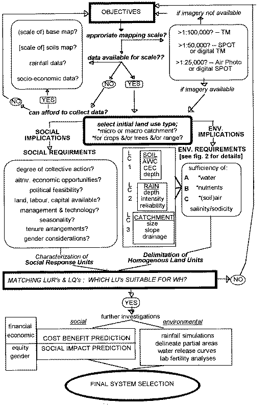
If the Framework is just that, a framework, the Guidelines series offer some practical advice on content as regards a particular LUT. The most relevant Guidelines for WH suitability assessment are for rainfed agriculture (FAO, 1983), and irrigated agriculture (FAO, 1985). WH is nebulous in that it has attributes of both, and in varying proportions as a function of the type of WH system being evaluated. Thus there is a need for guidelines specifically for WH for those involved in natural resource management in semi-arid lands, and in a format which accomodates the range of WH options available, applications possible, and actors involved. An EC review of SWC/WH (Catizonne, 1995) recommends the development of a GIS and/or expert system that can aid resource professionals considering WH. Quantitative land evaluation is currently tending towards a linkage of GIS, expert systems and crop simulation models (Wopereis et al., 1994). An example of such an approach specifically for WH, using the FAO Framework as a conceptual structure but operationalized within a GIS and Expert System, is outlined as Figure 1, in the form of an iterative decision tree developed as this research.
A tool within which to operationalize an assessment methodology for WH would be the Automated Land Evaluation System [ALES] (Rossiter et al., 1995). ALES is a useful practical planning tool because it is based on the FAO Framework, which has been widely used/emulated by natural resource professionals, but is structured as an expert system [ES], facilitating the involvement of `local experts' - i.e., land users - in the information generation process. Furthermore, it can be outputted in a map format that is widely understood by interfacing with a geographic information system [GIS].
GIS is a powerful tool which can be used in the field, to ensure relevance through client participation; results can consequently be achieved quickly and at low cost by using GIS for participatory mapping (Holme and Tagg, 1996; Hutchinson and Toledano, 1995). Further-more, certain GIS's such as Idrisi (Eastman, 1995) can accomodate uncertainty in decision making, using fuzzy sets and Baysian probabilities to represent and propagate uncertain facts and beliefs, which can be taken advantage of by `tagging' data generated by local experts with a degree of confidence provided by the expert. One should note, however, Burrough and Frank's (1995) caveat that GIS's implicitly embody a cultural concept of space; as such GIS can `impose' a way of viewing the landscape onto the local expert. Nevertheless, by using an ES in WH evaluation the gap between outside and local experts, probably the primary cause of the failure of WH to live up to its potential, can hopefully be diminished.
Expert Systems purport to emulate the human reasoning process (Chidely et al., 1993). By using an ES one hopes to elicit the heuristics [rules of thumb] local experts use to arrive at decisions, in this case regarding land use. This information is of great value for understanding the society in which the expert operates, both for potential application in situ and for ascertaining the validity of exporting expert knowledge to other semi-arid areas.
Linking indigenous knowledge and remote sensing in participatory survey
Indigenous soil classification [ISC] is based on visual characteristics [including crop results]. Remote sensing is generally restricted to the landscape surface; because both RS and ISC are `visual', they are potentially compatible. And not just compatible, but fundamentally complementary, as the former deals with a visual, spatial phenomenon as a snapshot in time, while the latter deals with the same type of phenomenon but continuously through time.
Indeed, RS could and should be used to test and extend the spatial validity of ISC beyond the current, generally ethnically defined, territorial limits. Assuming that physical conditions are sufficiently similar--as indicated by RS--[and the social conditions, as indicated by fieldwork] then the value of the knowledge of one particular group about environmental management, acquired at the cost of many decades of observation and trial and error, can be multiplied by utilizing it elsewhere. There is also great potential in working together with local people to interpret satellite imagery (Mutandi,1996; Patrick, 1996b). Mapping with RS, using indigenous knowledge [IK] as ancillary data, including rules of thumb about probable land use, Bronsveld et al. (1994) found land cover classification to be as accurate as by other methods. Furthermore, indigenous temporal data in the form of crop calendars were used to reconstruct vegetation cover for the dates of the RS imagery, enhancing interpretation.
Operationalizing the interaction with indigenous knowledge
All of which leads to the question of how to elicit IK: the first step in an expert system, a potential complement to RS, and essential in order not to waste the vast--and generally unrecorded--experience of local people for development in drylands. Neimejer (1995) rightly argues that it is not the fact of but manner in which IK is elicited that determines whether one acquires a true `insider' perspective or just a reclassification in terms of the interviewer's [subconsciously or consciously] imposed categories and interpretations. In anthropological jargon, emic and etic knowledge, respectivley.
Practical tools; participatory rural appraisal
Though no guarantee of emic or `insider' knowledge, Participatory Rural Appraisal [PRA] can help to avoid gross errors. PRA is basically a `toolbox' of techniques designed to help outsiders understand local circumstances, but in less time than by the traditional anthropological method of participant observation. PRA originally consisted essentially of interviews but has more recently evolved into a myriad of `games' and exercises such as walking transects together with farmers. The advantage of the latter is that an etic grill is less likely to be imposed, and serves as a useful mechanism to gain insight into the reasoning process itself, which is clearly central in constructing an ES (Freudenberger, 1995; Guillet et al., 1995). For a good collation of the available tools, see Schonhuth and Kievelitz (1994). A methodology for assessing WH potential should utilize PRA type tools as a proven way to operationalize the need to interact with and make use of the knowledge acquired by local communities and to understand the social circumstances into which a new technology is being introduced. A population is usually stratified into relatively homogeneous groups when using PRA. In this case these have been denoted `Social Response Units' [SRUs] and are analagous conceptually to the Framework concept of Land Units, in that they are defined on the basis of a presumed typical social effect of/response to WH.
This paper reports ongoing research in the form of a pilot study of limited scale in which the concepts and tools outlined above are being tested. The pilot study is being carried out at a mapping scale of 1:25 000, based on digital SPOT imagery, over an area of 1 000 km2 around Lake Baringo, Kenya. The study is now in its third year. Mean annual rainfall is 650 mm, but is bimodal in distribution, limiting the effective length of the growing season. There are three principal ethnic groups in the area; one solely pastoral, one agropastoral, and one principally agricultural. Participation in the market economy has been growing rapidly since the paving of the road to Nakuru in the early 1980s. There is a lack of grazing, at the same time as decreasing herd movement due to labour shortages as children are sent increasingly to school and hence great pressure on natural resources. Land adjudication, on a group ownership basis, is currently taking place. Over the last 15 years there have been three major WH projects in the area, for crop, tree, and range production. This unusual concentration, variety, and range of approaches in one place, and dealing with ethnic groups of different degrees of pastoral orientation, makes the study site particularly attractive for methodology development.
As most of the fieldwork so far has concentrated on the development of methodological tools for assessing physical suitability, substantive conclusions cannot yet be reached on the social side. Interaction with local people, however, along with visits to project sites clearly indicates that the WH projects in the study area succumbed to many of the planning errors listed above in the social arena. Current research is concentrating on testing the operational viability of the principles, techniques and software outlined above. In particular, the link between ALES and IDRISI is being explored, incorporating comparative, interactive and iterative image interpretation with different strata/interest groups among the local populace in the field, as well as the decision making under uncertainty tools which are an impressive asset of IDRISI. The main problem in fully taking advantage of ALES is the requirement of economic data in order to decide between LUTs on financial grounds, as such data [and particularly anything related to livestock] has proven to be a very sensitive issue and thus difficult to quantify.
The usefulness of `scenario building' with each social response unit is also being explored, in order to compare concepts of the landscape/resources and perceptions of space between SRUs [delimited principally on ethnic/degree of mobility grounds, but also within each ethnic group on the basis of age set, etc.] using IDRISI. Scenario building is also being used to hopefully predict the effects of different outcomes on each SRU for a range of possible WH systems in the form of georeferenced Cost Benefit Analyses and Social Impact Assessments [see fig. 1].
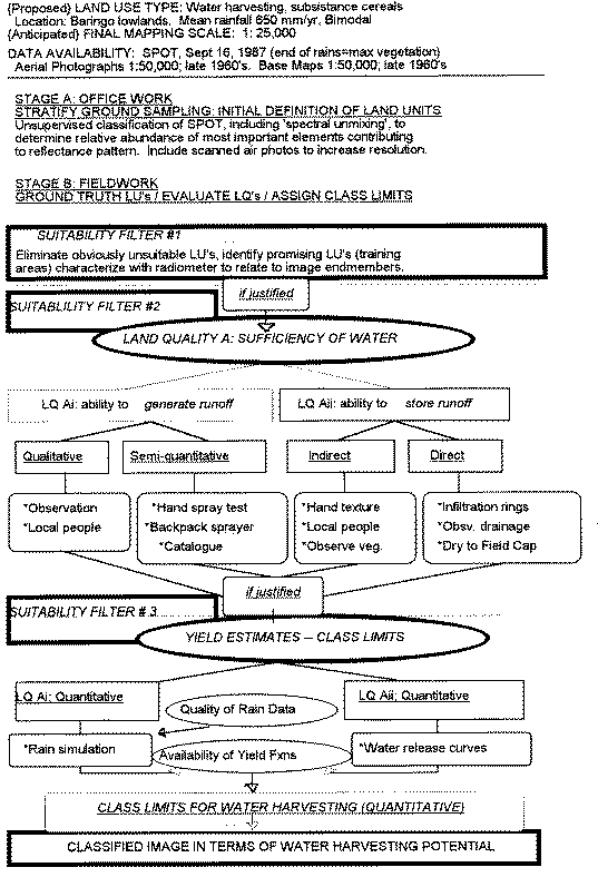
FIGURE 2
Assessing environmental suitability for water harvesting: example using the land quality `sufficiency of water'
The main concern on the environmental side of this research has been to operationalize the prediction of the key physical factor in WH, runoff. This is being attempted by linking rainfall simulation [RSim] to remote sensing of surface characteristics in order to be able to identify and characterize the range of runoff generating units in the study area and then extrapolate these to a nearby test zone to validate them.
Simultaneously, attempts are being made to reduce costs and increase practical usability by testing simpler means of, at least qualitatively, ranking LUs' runoff potential as well as by working with local people to manually classify hardcopy imagery. The relevant characterisitics of runon zones and their amenability to detection by RS is also being explored; the runon zones have LURs similar to that for irrigated agriculture, except that drainage is even more important in the case of WH because of the significant depth of ponding after large storms. Finally, assessment of environmental suitability has been systematized conceptually by fitting it into the Framework structure and in practice by using ALES and IDRISI [see figs. 1 and 2]. The system is conceived as hierarchical, though more in terms of cost of data collection than scale, though the two are related. Further and more precise but expensive modes of data collection are carried out only if and to the degree that cheaper, indicative results prove promising [see fig. 1 and in particular fig. 2 {note `Suitability Filters' 1-3}].
Working through Figure 2 as an example of options for and levels of assessment of LQ's
As WH systems are composed of runoff and runon areas irrespective of the particular proportions and degree of complexity of a given system, the basic principle for suitability assessment remains the same across systems. Nonetheless, there is a fundamental difference between Macro and Micro WH in that the former is a) more amenable to RS because it involves larger surfaces and b) entails more complex hydrology because it likely involves several or even many types of runoff contributing constituent surfaces. Furthermore, Macro WH likely involves a mixture of overland and channel flow; and probably requires the estimation of the partial area contribution (PAC) which, in semi-arid areas (Tauer and Humborg, 1992) is due to the short duration of the convective rainshowers, meaning that most runoff is lost before it reaches the drainage system.
The runoff area is assessed in terms of its ability to generate runoff, and the runon area principally but by no means exclusively in terms of its ability to store [and make available] the runoff generated. Fertility is usually the second most important limitation in the semi-arid areas in which WH is normally applied (Critchley et al., 1991). Furthermore, WH can potentially leach what nutrients are available (Stroosnidjer, pers. com., 1995), an often overlooked risk in WH. On the other hand, WH makes investment in nutrients [manure or inorganic] more worthwhile, as the fertilized crops are more likely to receive water (Tabor, 1995).
Figure 2 outlines the stages and options for defining LUs, assessing LQs and--if possible--setting class limits. Setting class limits for the LCs which constitute LQs implies a quantification of the effects of LCs on yield, for which data may not be available. The FAO originally hoped to specify class limit for LCs when creating the Guidelines for LE for Rainfed Agriculture, but this did not prove possible for this very reason (FAO, 1983). Now, however, FAO has produced Ecocrop 2, which is effectively a computerized database of effects on yield of a range of environmental factors, and represents a very important data source. The procedure outlined in Figure 2 is necessary in order to be able to match the LURs of WH LUTs to the LQs of the LUs delineated in the survey. Note that Figure 2 represents the structure of the assessment methodology for every LQ, but that the content in this case is only for LQA: ability to make sufficient water available, for the LUT under consideration [crop/tree/grass.]
As can be seen from Figure 2, LQ Ai can be assessed in a qualitative and/or semi-quantitative manner as a first attempt, depending on the initial degree of knowledge about the area, the objectives of the survey, and the resources available [see Figs. 1 and 2].
Suitability Filter Level 2: Qualitative asssessment of runoff potential
There are many simple, visual indices of erosion status and/or hazard which include tips on recognizing telltale signs of runoff which assign qualitative rankings or values for attributing -in combination with other factors - erosion classes. One of the more systematic guides and specifically developed for semi arid areas [rangeland in Australia] is the CSIRO Rangeland Soil Condition Assessment Manual (Tongway, 1994). Local people can also be an excellent fount of knowledge about soils.
Suitability Filter Level 2: Semi-quantitative assessment of runoff potential: `Catalogues' of rainfall-runoff relationships
If working in the Sahel, one has access to the brilliant `Catalogue des �tats de surface' (Casenave and Valentin, 1989). The Catalogue, from a user's perspective, is essentially a collection of photographs of typical surface types found in the Sahel, with associated diagnostic features, and for each surface type an equation is given which allows one to calculate runoff solely from rainfall depth and antecedent moisture; the non meterological parameters are implicit because each equation is an empirical relationship tied to a particular surface type.
In practice, Puech (1994) found that in many areas the catalogue gave runoff values up to 300% different from rainfall simulations he carried out in situ, within the zone of validity. The Catalogue is perhaps overambitious in hoping to provide models valid for a large part of the Sahel. It would be preferable to apply the Catalogue concept, but on a local scale, using Rsim in situ; indeed this is a necessity in semi-arid areas outside the Catalogue's `zone of validity'.
The assessment of suitability as runon areas is similar to assessing suitability for rainfed and particularly irrigated crops. The key hydrological Quality, ability to store runoff and denoted Aii in this case, is essentially the available water capacity [AWC], ie the quantity of water held between field capacity [FC] and the permanent wilting point [PWP]. AWC is basically a function of soil texture and depth [with a volume reduction for stoniness], and although PWP is set at an `average', somewhat random value, it should be crop specific. The most applicable methods by which to determine crop water requirements and yield reduction as a function of water shortage are outlined in FAO (1986). These have been applied to WH planning by Critchley and Siegert (1991), who also uses them as a basis to calculate runoff : runon area:
![]() (1.1)
(1.1)
For WH purposes, the crop [and development stage] specific AWC required in the potential runon zone to satisfy the crop water requirement can be given as :
![]() (1.2)
(1.2)
where:
RAWCmin is the minimum required water holding capacity [at available tensions]in mm/m
Dpmax is the longest period between two storms of a selected size, for a chosen probability exceedance [from rain records] days
ETO is potential evapotranspiration mm/d
KCmax is the maximum evapotranspirative coefficient for the crop, dimensionless
RDeff is the effective rooting depth, ie to a hardpan or parent material and deducting stone volume m
FCDp is the permitted water deficit, as a proportion of AWCmax, there is a yield reduction due to water stress, dimensionless
(Adapted from Tauer and Humborg, 1992)
AWCmin is a LUR which must be met or exceeded in a matching procedure to the AWCmin of available LUs. AWCmin for each LU can be assessed by a number of methods, depending on the stage in the assessment procedure [see Fig. 2] and finances available. Ideally the soil samples from each LU would be sent to the lab to determine the water release curves and from these the AWC directly. However, in the earlier stages or if this would be too expensive, it is also possible to estimate, or at least rank, AWC for each Land Unit.
Suitability Filter Level 2: Indirect assessment of runoff storage
AWC can be estimated to an order of magnitude from texture (Landon, 1991), and texture determined with suprising accuracy from simple hand tests, as demonstrated in the study area by comparing our field results with lab particle size distribution analyses. Because hand soil textural determination is tactile, visual and intuitive it is a `bridge concept' to local perceptions of the soil. AWC can also be deduced from associated vegetation if local vegetation water requirements are known or can be learned from local people. Using relevant PRA tools, it is always important to inquire of local people regarding which soils are considered `thirsty' and why.
Indigenous soil classification is generally based on several axes such as crop suitability, labour requirements, associated vegetation and position in the landscape, whereas scientific soil classification [SSC] is hierarchical and soil type is deduced from predetermined, systematic, and - ideally - quantifiable indices (Kerven, 1995). As IK is largely visual, ISC is almost solely based on topsoil characteristics. Sikana (1994) notes that in Zambia farmers recognized three soil classes - based on topsoil - where SSC recognized only one, based on subsoil. SSC is based on subsoil properties in the interest of universal applications of the results. ISC is in almost always related to specific uses and circumstances; in this sense the logic used by local people to match crop and available resources to soil type is very similar to the logic of the Framework; hence the two are potentially compatible and mutually comprehensible and an appropriate logic on which to build a WH assessment methodology.
It should be remembered, however, that in spite of often possessing great local environmental knowledge, local people should not be seen as some sort of `noble savages' with innate knowledge of `mother earth'; ISC is fundamentally practical and is limited by the experience of the individual. Furthermore, as Ryder (1994) points out, farmers rank soils better than justified for familiar uses. The best role for IK when assessing the potential for introducing new techniques is to derive information about the LCs known to be critical for WH from the experiences of local experts with WH in areas in which it is already practiced. This, then, should be the primary role of the outside professional when assessing WH potential; as a bridge between knowledge from the outside world - primarily in written form - and local knowledge and aspirations, primarily in oral form.
Suitability Filter Level 2: Direct assessment of runoff storage
The most direct assessment of AWC is of course in the lab, which may be a justifiable expense at suitability assessment level 3, for areas already selected for WH, as this data are required for calculating C:C ratios for project implementation. When still selecting promising areas however (i.e., level 2 assessment) there are cheaper `direct' ways of observing the behaviour of a potential runon area under simulated conditions of ponding behind a bund. This can be achieve using a single or double ring, which although rightly criticized - as a means of assessing infiltration under rainfall due to surface disturbance and a standing head - is perfectly suited to assessing infiltration behind a bund, which has a standing head up to 30 cm, and over a disturbed area due to cultivation. Although technically a double ring is preferable because, by reducing boundary effects, it more accurately reflects the theoretical definition of infiltration as vertical movement into the soil, in practice it is unlikely to be worth the extra water involved under difficult survey conditions. In fact the lateral movement can be an advantage, as the shape of the wetting front is an indication of subsoil texture and alerts the observer to the presence of less permeable layers if the soil is dug away at the end of the test (Roose et al., 1995); which is critically important to predict drainage problems, which would lead to waterlogging given the large inundations received with WH.
Filter level 3: Assessing LQ Ai (Ability to Generate Runoff)
Quantitative Ways of Assessing Runoff
Moving on now in Figure 2 to the final level in terms of precision but also cost, local rainfall simulation would be the appropriate technique at this stage in the methodology. The choice to use Rsim would likely be made after an initial selection of promising LUs on which further, quantified, data are required, or in the case of a small area/large scale survey being carried out from the beginning. The goal of Rsim is to obtain a value which is a best estimate of actual R-R, for the chosen storm intensity and duration, from which to calculate Catchment:Cultivated area ratios for WH feasability assessment or implementation, assuming that the necessary rainfall data are available or can be estimated.
Forty-eight rainfall simulations have been carried out at 15 sites so far, at intensities of 10 to 30 mm/hr, for durations of at least one hour each. Contrary to the typical use of Rsim for erosion studies, which is interested in erosive events involving intensities greater than an erosive threshold [generally taken to be 25 mm/hr for the tropics, but often using much higher intensities in order to ascertain the effects of extreme events], Rsim for WH requires knowledge of the threshold depth and intensity which produces runoff. In order to help assess the effects of the crust and of depression storage, the experiments were repeated with the crust perforated, roughened, and completely removed. It should be noted that there can be a `threshold intensity' at which the crust appears to break (Patrick, 1993), which may explain a `wave effect' sometimes observed with runoff readings using Rsim in the area.
The rainfall simulator design chosen for this study is a `drip type', whereas the most commonly used simulator design is a `spray type' because it attains more realistic KE at lower simulator heights as the drops emerge at velocity and/or can be sprayed upwards to increase effective fall height. The drip type was chosen in this case because of the much lower water consumption; to carry out two simulations of one hour each at 30 mm/hr onto a 1m2 plot would require approx 80 L versus approx 2 000 L for an average spray type. As water is obviously in short supply in semi-arid areas, the drip type is more practical for remote areas, provides greater control over water source and therefore quality, is much more portable and is much cheaper for developing country use. A spray type typically costs $5-10 000 (Ben Asher and Berliner, 1994); the one used in the pilot study costs less than $500 to make.
In short, rainfall simulation can be a valuable tool for runoff response when assessing WH potential, however availability of the rainfall data required to make the exercise worthwhile by allowing one to select a realistic design intensity, and the limitations of the particular simulator chosen, must be borne in mind before deciding whether to assess runoff potential by this method and when interpreting the results.
The question of the validity of upscaling from a m2 Rsim plot to a macro catchment which can be thousands of times larger is obviously not straightforward. This is a massive topic which will not be discussed here except to outline a key concept of relevance to assessment of runoff potential for Macro WH. The partial area concept [PAC], originally developed for humid climates (Betson, 1964), denotes the differential contribution of different zones within a catchment to runoff at the outlet. The explanation proposed for humid areas is the existence of more saturated belts of reduced infiltration capacity around the drainage network, which therefore contribute a greater proportion of the final runoff. The PAC phenomenon has also been observed for arid climates (Yair et al., 1978). The explanation in this case proposed by Tauer and Humborg (1992) is that the short duration of rain events means that rain falling on the `catchment' at a distance from the drainage network will infiltrate in situ and therefore not contribute to runoff.
Predicting runoff by additive calculation from Catalogue surface types on eight Sahelien catchments of various sizes was found, on average, to yield double the actual runoff (Puech, 1994). Similarly, on a 114 ha rocky catchment in Mali, Ben Asher and Humborg (1992) found that not taking PAC into account led to overestimates of up to 600% compared to straightforward upscaling from Rsim on and Catalogue values for the surface types constituting the catchment. Furthermore, they found that there is very little change in the size of the partial area in response to rainfall. It should, therefore, be possible to delimit a partial area for a given catchment when assessing runoff potential for Macro WH, within a reasonable margin. The position and slope of the drainage network can be calculated from digital photogrammetry of scanned air photos, from satellite imagery using newly developed processing techniques (Ichoku et al., 1996), by direct measurement or, if available, from digitized topo maps.
The development of a methodology for assessing the physical potential for WH has two goals: a) to develop or test the utility of existing inexpensive field based tests and to compare their accuracy to more expensive procedures and b) to characterize LUs in terms of runon and runoff potential in order to determine which types of LUs and which characteristics of the LUs are discernible from optical remote sensing. Some of the tests have been described above. The rest will only be listed.
At Level 2 of Figure 2, qualitative and semi-quantitative assessment, 56 sample sites have been characterized by:
--Hand texture analysis; consistence--hand plasticity and stickiness, strength using penetrometer at three shallow depths; pH using colorimetric method [can be >1 unit different from glass electrode (Stocking, 1987) but sufficient for survey purposes (Landon, 1991)]; carbonates [10%HCL]; average aggregate size; pore abundance and type with hand magnifier; visual evidence of water movement and erosion; micro and macro topography; basal and aerial cover; soil colour (Munsell, dry); hand sprayer, with and without crust; surface stoniness; GPS location; hand spectoradiometry; evidence of crust--depth and nature; cracking; photograph.
At Level 3 of Figure 2, quantitative assessment, at 18 sites where Rsim carried out, the above plus the following.
--Bulk Density; Field Capacity; Air Filled Porosity; Total Porosity; Backpack Sprayer; Single Ring--and dig under to describe wetted area and to check effective depth, stoniness and roots; Drainage under undug Ring after 24 hours; Rainfall Simulation--photographing suface changes [especially aggregate breakdown, closing of cracks and incipient ponding], digging under for wetting depth, returning after 24 hours to determine if change in strength.
In summary the physical tests, mostly selected for their rapidity, simplicity and low cost, have proven to be satisfactory to Level 2 accuracy requirements when validated against published lab data; they allow for a semi-quantitative ranking of LU's. In addition, they have proven to be practicable under tough field conditions and manageable for field assistants. In terms of limitations, fertility, salinity/sodicity, and Permanent Wilting Point in particular are important and cannot quickly and/or cheaply and/or accurately be determined outside the lab; a cost benefit analysis should be used to ascertain at Level 3 whether lab work is justified.
From the sky down: techniques relevant for assessing MACRO WH suitability
Assuming that it has been possible to set some class limits for LCs, and therefore that LUs have been defined in some semi-quantitative manner and matched to WH LURs for potential runoff and runon areas, the question is now how to extrapolate the results from the few sampled ideal types assumed to be representative of the study area as a whole. This constitutes the last box in Figure 2. There have been many attempts to take advantage of RS to predict runoff from ungauged catchments. The most common approach in semi-arid regions has probably been to use RS to map land use/cover to help determine the SCS Curve Number (Sharma, 1992; Zevenbergen et al., 1988). These report very good results and without taking the PAC phenomenon into account.
Nonetheless, Tauer and Humborg (1992) caution that the CN system is not relevant for the Sahel because it is callibrated for extreme events in the USA and generates virtually no runoff below 40 mm rainfall, which is larger than most rain events in the Sahel. In any case, the size of catchments amenable to this approach are larger than the catchment area commonly used in WH. The fundamental irony in attempting to use RS to map WH potential is that the scale `visible' to satellite sensors is suited to assessing Macro WH, but the most widely used and socially realistic system is Micro WH because it is based on individual ownership, which involves catchment areas invisible to RS.
From the ground up: techniques relevant for assessing MICRO WH suitability
The other approach taken specifically in the Sahel to WH starts from the ground and aggregates upwards to the `point of visibility' on RS imagery and is of greater relevance to WH because it deals with surfaces as small as 100 m2, still within the Micro WH category. This approach in semi-arid Africa has been the work of French scientists and driven by the opportunity to take advantage of an existing resource, the Catalogue, by linking it to RS. As the Catalogue is based on `elemental surfaces' of 1 m2 the problem has been how to aggregate up to about the 1 ha minimum discernible area or `effective pixel' on SPOT or TM [once various georeferencing errors add up]. There are a number of possible ways of doing this.
Casenave and Valentin (1989) established a relationship between a classic classification of `visible features' of the landscape by RS in terms of geomorphic features such as `rocky slopes' visible on the imagery and their constituent surfaces. The surfaces typically linked to each RS class are grouped in a manner analogous to soil associations and consist of, for example, 75% surface type A and 25% surface type B. The relationship allowed prediction of runoff on an unmapped catchment by calculating from the Catalogue the net runoff as a function of the proportion of the catchment occupied by each association and the presumed proportion of surface types within each association as previously determined from training areas. PAC was not considered but gave a regression coefficient of 0.80 with respect to measured runoff. The other approach would be to try to pick up the reflectance characteristics of the elemental associations directly where they occur in large enough patches to serve as training areas. This was attempted by Puech and Laily (1990) but only four of twelve associations could be distinguished. In response, an effort was made to correlate the associations to vegetation and soil types, as these are visible to RS (Puech, 1994) and this has proved to be feasible. Their current research involves the development of quick transect based surveys based on the Catalogue, designed to furnish a large enough sample to accurately interpret imagery on an operational basis (Lamach�re and Puech, 1995).
Yet another possibility is to start on the ground not just with Rsim but also with radiometric reflectance; ie to relate the two in situ, and then relate this correspondance to satellite imagery. A hand held spectoradiometer is being used in the pilot area to determine whether a relationship can be established between propensity to generate runoff and spectral signature either directly or via proxy measure(s).
The results of the study so far indicate that there is substantial potential for the assessment of WH suitability for semi-arid areas. Any assessment methodology must be demand driven in terms of social and environmental suitability. An appropriate logic by which to match supply and demand is the FAO Framework for Land Evaluation. The `matching' logic is similar to that by which local people classify soil; with respect to a specific use, and in terms of requirements and limitations for a given use. The Framework can be operationalized within an expert system, which allows input of data from local resource experts and output--by interfacing with a GIS--in map form, a commonly understood representation and basis for land use planning with local people. Furthermore, GIS can be used to create scenarios with different local `interest groups', stratified into `Social Response Units' using PRA tools. These concepts and techniques are currently being explored in the study area, comparing in particular groups statified on the basis of degree of pastoral orientation, on the hypothesis that the concept of investment in land/a fixed location is a critical factor for predicting WH suitability. This hypothesis is derived from a study of the experiences of three major WH projects in the area.
On the environmental side, assessment of WH suitability involves different techniques for runoff and runon areas but the same approach in that `Suitability Filters' corresponding to progressively more precise, quantified but costly techniques are applied to the most promising Land Units [as they are defined, on an iterative basis]. The appropriate level at which to begin and end an investigation is determined on the basis of specified objectives and corresponding scale, data availability and resources [Figure 1]. A clear but flexible statement of purpose from the beginning of data collection therefore is important. For assessing runon suitability simple tests have proven to be very promising and cost effective, and can be related to local soil knowledge because they are primarily visual. Assessing suitability for runoff necessitates more quantitative data and involves larger unit areas, and thus amenable to rainfall simulation and remote sensing. Rainfall simulation has proven to be a useful and cost effective tool in this research.
Image interpretation provides a natural link to indigenous knowledge because both are fundamentally visual phenomena and complementary to IK because the former is time static but the latter time dynamic. Furthermore, remote sensing can potentially be used to extrapolate the spatial validity of indigenous knowledge beyond the territorial boundaries of the group which has acquired this knowledge through many years of trial and error. This possibility is currently being explored.
Ultimately the degree to which suitability for WH can be assessed depends on the degree to which a critical analysis of past experience of WH signals the key social and physical factors which define whether and which type of WH system is feasible and beneficial and for whom and under what circumstances. Technology is not socially neutral and thus Micro and Macro WH have different social requirements and implications and both must be viewed in a dynamic context of trends in the larger economic environment. The degree to which suitability can be assessed also depends on amenability to the tools by which they are assessed; for example, Micro WH may not be amenable to remote sensing. Thus a range of potential tools is being examined by this research in order to assess suitability for suitablility assessment.
On the basis of an extensive general literature review of factors explaining WH adoption and the experiences of projects in the study area, in addition to social and environmental data sets being collected for this pilot study and by a variety of methods, the current research is attempting to operationalize the prediction of social and environmental suitability for WH and in a manner which incorporates local views and knowledge and in a rapid and cost effective way. Initial indications are promising, however the data analysis has not yet reached the stage whereby a final judgement of the usability of the methodology can be made.
This research is made possible in part by: The Harold Wingate Foundation; The Royal Society; The British Geomorphological Research Group of the Royal Geographical Society + IBG; The Committee of Vice-Chancellors and Principals of the Universities of the UK; The Univ of London Central Research Fund; The Graduate School, UCL; SOAS; Geography Depts, UCL and SOAS. [And in kind:] GRID-UNEP, Nairobi; DRSRS, Nairobi; The Regional RS Centre, Nairobi.
Thanks are due for valuable discussions of parts of the material constituting this paper to: Mr. W Critchley, UK; Prof A Dietz, Prof A Imeson, Prof P Jungerius, Univ of Amsterdam; Ir W Hoogmoed, Prof L Stroosnijder, Dr M Mulders, Dr G Epema, Dr H Lovenstein, Prof R Feddes, Wageningen; Prof D Prinz, Karlsruhe Univ; Dr C Puech, Dr JM Lamachere, Prof E Roose, Montpellier; Prof M Girard, INA- Paris; Prof J Ben-Asher, Dr P Berliner, Dr A Karnieli, Desert Research Institute, Israel; Prof A Yair, Hebrew Univ; Dr K Siegert, Dr R Brinkman, FAO, Rome; Dr R Escadafal, ISPRA, Italy; Dr M McCall, ITC, Holland.
Ben-Asher, J., and Berliner, P.R. 1994. Runoff irrigation, in Tanji, K. K., and Yaron, B., eds., Advances in Agricultural Sciences [Vol. 22 ed.]: Berlin, Springer Verlag, p. 127-154.
Ben Asher, J., and Humborg, G. 1992. A partial contributing area model for linking rainfall simulation data with hydrographs of a small arid watershed: Water Resources Research, v. 28, No.8, p. 2041-2047.
Betson, M.A. 1964. What is watershed runoff?: Journal of Geophysical Research, v. Vol.69, No.8, p. 1541-1552; N.
Bronsveld, K., Chutirattanapan, S., Pattanakanok, B., Suwanwerakamtorn, R., and Trakooldit, P. 1994. The use of local knowledge in land use/cover mapping from satellite images: ITC Journal, v. 1994-4, p. 349-358.
Burrough, P.A., and Frank, A.U. 1995. Concepts and paradigms in spatial information: are current geographical information systems truly generic: International Journal of Geographical Information Systems, v. 9, No.2, p. 101-116.
Cattizone, M. 1995. Synthesis of EC workshop on indigenous soil and water conservation and water harvesting techniques., in Cattizone, M., ed., New Challenges for Research on Use and Management of Natural Resources EUR 15717: Luxembourg, EC DG12, p. 23-36; N.
Chidley, T.R.E., Elgy, J., and Antoine, J. 1993. Computerized systems of land resources appraisal for agricultural development. World Soils Resources Reports no. 72: Rome, FAO, 245 p.
Critchley, W. 1987. Some Lessons From Water Harvesting In Sub-Saharan Africa. Report from a workshop held in Baringo, Kenya, 13-17 October 1986: Washington DC, The World Bank, 58 p.
Critchley, W., Reij, C., and Seznec, A. 1992. Water harvesting for plant production. Vol II: Case studies and conclusions for Sub-Saharan Africa. World Bank Technical Paper Number 157: Washington, D.C., World Bank, 134 p.
Critchley, W. and Siegert, K. 1991. Water Harvesting: Rome, FAO, 133 p.
FAO. 1976. A framework for land evaluation. FAO Soils Bulletin No.32: Rome, FAO, 72 p.
FAO. 1983. Guidelines: land evaluation for rainfed agriculture. FAO Soils Bullletin No. 52: Rome, FAO, 237 p.
FAO. 1985. Guidelines: land evaluation for irrigated agriculture. FAO Soils Bulletin No.55: Rome, FAO, 229 p.
FAO. 1986. Yield response to water, FAO Irrigation and Drainage Paper No. 33: Rome, FAO, 193 p.
FAO. 1993. Guidelines for land-use planning [FAO Development Series ed.]: Rome, FAO, v. 1, 96 p.
FAO. 1995. Agricultural investment to promote improved capture and use of rainfall in dryland farming [FAO Investment Centre Technical Paper ed.]: Rome, FAO, v. 10, 46 p.
Freudenberger, K.S. 1994. Challenges in the collection and use of information on livelihood strategies and natural resource management, in Scoones, I., and Thompson, J., eds., Beyond Farmers First; Rural people's knowledge, agricultural research and extension practice: London, ITDG Press, p. 124-132.
Guillet, D.W., Furbee, L., Sandor, J., and Benfer, R. 1995. The Lari Soils Project in Peru-A methodology for combining cognitive and behavioural research, in Warren, D.M., Slikkerveer, L.J. and Brokensha, D., eds., The Cultural Dimension of Development: Indigenous Knowledge Systems: London, Intermeditate Technology Publications, p. 579.
Holme, D. and Tagg, J.G. 1996. Remote sensing and GIS in community based natural resource management in Namibia in Proceedings of an International Conference on the Application of Remotely Sensed Data and GIS in Environmental and Natural Resources Assessment in Africa, Harare, March 15-22, 1996: Harare, ERSI, 391-394 p.
Hudson, N.W. 1991. A study of the reasons for success or failure of soil conservation projects, FAO Soils Bulletin No. 64: Rome, FAO, 65p.
Hutchinson, C.F. and Toledano, J. 1993. Guidelines for demonstrating geographical information systems based on participatory development: International Journal of Geographical Information Systems, v. 7, no. 5, p. 453-461.
Ichoku, C., Karnieli, A., Meisels, A. and Chorowicz, J. 1996. Detection of drainage channel networks on digital satellite images: International Journal of Remote Sensing, v. 17(9), p. 1659-1678.
Kerven, C., Dolva, H. and Renna, R. 1995. Indigenous soil classification systems in northern Zambia, in Warren, D.M., Slikkerveer, L.J., and Brokensha, D., eds., The Cultural Dimension of Development: Indigenous Knowledge Systems: London, Intermeditate Technology Publications, p. 579.
Lamach�re, J. M. and Puech, C. 1995. T�l�d�tection et cartographie des �tats de surface. In Pre-Proceedings of the International Workshop on Remote Sensing and Water Resources Management, Montpellier, 29.11-01.12.1995: Montpellier, FAO, B1;1-16 p.
Landon, J.R. (ed.) 1991. Booker Tropical Soils Manual: Harlow, Longman, 474 p.
Mutandi, R. 1996. Down to earth: A framework for integrating RS data into indigenous knowledge systems for land resource management in southern Africa in Proceedings of an International Conference on the Application of Remotely Sensed Data and GIS in Environmental and Natural Resources Assessment in Africa, Harare, March 15-22, 1996: Harare, ERSI, 51-52 p.
Niemeijer, D. 1995. Indigenous soil classifications: Complications and considerations: Indigenous Knowledge and Development Monitor, v. 1: January 1995, p. 20-21.
Office of Technology Assessment 1988. Enhancing Agriculture in Africa [OTA-F-356 ed.]: Washington DC, US GPO, 328
Pacey, A. and Cullis, A. 1986. Rainwater Harvesting: London, Intermediate Technology Press, 216p.
Patrick, E. 1993. Rainfall Runoff Analysis at Wadi Mashash. Unpublished report: Sde Boker, Desert Research Institute, Ben Gurion University.
Patrick, E. 1996a. Mapping water harvesting suitability by integrating remote sensing with indigenous knowledge in Proceedings of an International Conference on the Application of Remotely Sensed Data and GIS in Environmental and Natural Resources Assessment in Africa, Harare, March 15-22, 1996: Harare, ERSI, 385-388 p.
Patrick, E. 1996b. Underutilized ephemeral water resources: identifying resource and management potential in semi-arid environments in Proceedings of the European Seminar on Water Geography; Perceptions of the values of water and water environments: London, SOAS University of London, 61-64 p.
Puech, C. 1994. Du m2 au bassin versant: La difficult� du passage d'�chelle, in Journ�es Hydrologiques de l'ORSTOM 09.1994: Montpellier, ORSTOM, p. 10.
Puech, C. and Laily, B. 1990. Utilisation de la t�l�d�tectionsatellitaire pour la caract�risation hydrologique de neuf bassins versants au Burkina Faso: Ouagadougou, PNUD-CIEH, 80 p.
Reij, C., Mulder, P. and Begemann, L. 1988. Water harvesting for plant production [World Bank Technical Series ed.]: Washington DC, The World Bank, v. 91, 98 p.
Reij, C., Scoones, I. and Toulmin, C. 1996. Sustaining The Soil: Indigenous soil and water conservation in Africa: London, Earthscan, 260 p.
Roose, E., Blancaneaux and Luiz de Freitas, P. 1994. Un simple test de terrain pour �valuer la capacit� d'infiltration et le comportement hydrodynamique des horizons p�dologiques superficiels: m�thode et examples: Cahier ORSTOM Pedol., v. 28, 2, p. 10.
Rossiter, D.G., Tolomeo, M. and Van Wambeke, A.R. December 1995. Automated Land Evaluation System, ALES, Ver. 4.6,: Ithaca, N.Y., Agronomy Dept., Cornell Univ.,.
Ryder, R. 1994. Land evaluation for steepland agriculture in the Dominican Republic: The Geographical Journal, v. 160, Part 1, p. 74-86.
Schonhuth, M. and Kievelitz 1994. Participatory Learning Approaches; An introductory guide [Schriftenreihe der GTZ ed.]: Eschborn v. 183, GTZ, p. 248.
Sharma, K.D. and Singh, S. 1992. Runoff estimation using Landsat Thematic Mapper data and the SCS Model: Hydrological Sciences, v. 37, No.1, p. 39-51.
Siegert, K. 1994. Introduction to water harvesting: some basic principles for planning, design and monitoring in Proceedings of the FAO Expert Consultation, Water Harvesting for Improved Agricultural Production, Cairo, 21-25 November, 1993: Rome, FAO, 9-22 p.
Sikana, P. 1994. Indigenous soil characterization in Northern Zambia, in Scoones, I., and Thompson, J., eds., Beyond Farmers First; Rural people's knowledge, agricultural research and extension practice: London, ITDG Press, p. 80-82.
Stocking, M. 1987. Field and Laboratory Handbook for Soils: Norwich, Univ. of East Anglia, 85 p.
Stroosnidjer, L. 1995. Personal Communication
Tabor, J. and Hutchinson, C. 1994. Using knowledge, remote sensing and GIS for sustainable development: Indigenous Knowledge and Development Monitor, v. 2 No.1, p. 2-6.
Tabor, J.A. 1995. Improving crop yields in the Sahel by means of water-harvesting: Journal of Arid Environments, v. 30, p. 83-106.
Tongway, D. 1994. Rangeland Soil Condition Assessment Manual: Canberra, CSIRO, 69 p.
Wopereis, M.C.S., Kropff, M.J. and Bouma, J. 1994 Soil data needs for regional studies of yield constraints in water-limited environments using modeling and GIS, in Wopereis, M., Kropff, J., Bouma, A., van Wijk, A., and Woodhead, T., eds., Soil Physical Properties: Measurement and Use in Rice-Based Cropping Systems: Los Banos, IRRI, p. 86-104.
Yair, A., Sharon, D. and Lavee, H. 1978. An instrumented watershed for the study of partial area contribution of runoff in the arid zone: Z Geomorphol, v. 29, p. 71-82.
Zevenbergen, A.W., Rango, A., Ritchie, J.C., Engman, E.T. and Hawkings, R.H. 1988. Rangeland runoff curve numbers as determined from Landsat MSS data: International Journal of Remote Sensing, v. 9, No. 3, p. 495-502.
![]()
![]()
![]()