![]()
![]()
![]()
Tuomo Häyrinen1
1
Senior Ranger in Finnish Forest and Park Service, Eastern Finland Park Area, Mikkeli, Finland.
Abstract
Landscape is partially formed by the law of nature and partially by the actions of human beings. How one interprets a forest road within a landscape is influenced by one's own personal experiences, objectives, hopes and attitudes.
Landscaping is very much a matter of aesthetics. Anyway in forestry and forest road building a planner is faced with the task of optimizing economics, ecology and aesthetics at the same time.
As an example some noticeable features in landscapes are listed when planning forest roads. A very important point to notice is the effects of the consequent functions and features of a road after it has been built. That is why forest management planning, forest road planning and landscaping are always bound together.
The planning method and the tools in forest road planning, with special concern for landscaping, depend on each planning case and available resources. Very often a visual method with a "multi-professional good insight" is the best method. The numerical methods for landscaping come in later, especially for some routine road planning cases.
In this presentation some advantages of advanced methods and tools are discussed. It is also pointed out that a planner in practice must make careful observations on the ground level. The observations in landscaping have to be done from many different look-out spots and different view distances.
The beauty of landscapes reflects the tones of each era. Cultural backgrounds and development phases of societies have a remarkable influence on landscape values. Landscaping in forestry and in road building is the mirror of the surrounding values in societies. When producing proper beautiful landscapes, a forest road planner must nowadays use various skills besides the technical know-how. Many constraints and public awareness require that conflict management and public participation come into the forest road planners' "tool-box".
Introduction
In the different phases of planning forest road networks and single roads there are multiple needs, besides wood transport, that must be taken into consideration. These are, for example, biodiversity, key biotopes, endangered species, entity of wilderness and protection areas, hunting, fishing, other local recreational and socio-economic needs and landscaping.
In this presentation, landscaping is looked upon not only as part of different management planning approaches but is also examined separately. The use of three cases is intended to show some personal perceptions that the author of this paper has faced at a practical level in Finnish forestry.
Personal interpretation of landscapes
The landscape is a natural complexity observed through the senses. It is primarily visual, observed through the sense of sight. Other sensory observations also affect one's experience of the landscape.
Forest roads have remarkable influence on landscape. In the extremist's attitude a forest road is generally a negative feature for natural landscape. That "philosophic" attitude is not discussed in this presentation. On the contrary, in some cases a forest road makes it possible for people to get a sight over a beautiful landscape. It can be generalized that a newly built road is worse for the landscape than a settled road because of excavation, transported materials and scraped vegetation.
Exactly how one interprets a forest road within a landscape is influenced by one's own personal experiences, objectives, hopes and attitudes. Consequently, different people's assessments of the same road in a landscape can vary widely.
Some definitions of landscaping
Landscape is formed of different parts: bedrock, soil, water, air, flora, fauna and man-made particles. Landscape has a structure that is formed partially by the law of nature and partially by the actions of human beings. Landscape is primarily perceived visually but at the same time other sensory observations affect one's experience of the landscape. The visual outlook of a landscape is dependent upon different features of the comprising parts: quality, form, mutual order, size, colour, etc. (Iisakkila 1977).
Quite often landscape is divided into two categories: near-distance and far-distance landscapes. This division is based on the fact that the three-dimensional sight reaches approximately up to 100 m. This area is called near-distance landscape. In this area a human being can see single objects, their position with respect to each other, colours, shapes and light sources. Distances of over 100-200 m are classified as far-distance landscapes. This range of vision depends on the viewer's position and visual obstructions (Iisakkila 1977 and Higuchi 1988).
The terms "near-distance and far-distance landscape" are important elements in landscaping, because they determine the precision and scaling of plans. For example, a forest road, which people is viewing from very far or is in fast motion, does not need very sensitively detailed plans. This is because those details are out of vision.
Approaches in forest road planning
Generally it is possible to see some megatrends which have arisen lately in forest management and forest road planning: environmental assessment, various numbers of goals and multiple usage of natural resources. When combining proper landscaping with forest road planning and making compromises between different goals, the planning system itself must also be economically reasonable. (The organizational matters are discussed in other presentations.)
Different approaches in forest road planning:
A. Traditional planning:· forest plotwise proposals in the site
· based on guidelines and professional experiencesB. Economic method:
· different goals are measured with the same scale
· economic analyses (marginal profit)C. Numerical optimization
· mathematical programmes and heuristics
· an optimal combination to be foundD. Combinational approaches
· case-wise combinations of the above
· traditional planning must be joined with the "more sophisticated methods" - the planner must interpret and control the planning in practice.
When a certain input and effort is to be invested in landscaping in the road building exercise, one must classify different types of landscapes. In different cases landscape classification varies. Usually large entities are studied first - smaller scale and detailed planning are studied later.
As an example the following points must be considered in near and far-distance landscapes (Finnish FPS 1994 and Niemelä 1995):
· high elevations in the terrain· lake and river systems
· small-scale formations like tiny hills and rocky surfaces
· swamps and other wet sites
· heritage landscapes, like old meadows, old homesteads
· geomorphologic formations, like ridges, gullies or small canyons
· areas visible from a lake, from another road, from a human settlement, or from a scenery stop-spot
· a silhouette of hilltops and shoreline.
All the consequent functions and features of a planned road must be taken into consideration in the planning phase as well. A very important point to notice is the effect of the following:
· Possible consequent constructions:- electric/telephone lines with poles by the roadside
- look-out spot and other communal services etc.· Subsequent forestry operations
All those consequent features of the landscape may have a greater influence than the road itself. That is why forest management planning, forest road planning and landscaping are always bound together.
Aesthetics
In road planning, as well as in forestry generally, there are always three major subjects to be optimized: economics, ecology and aesthetics. For example, if the most beautiful place for a road is at the bottom of a valley, this may cause other problems. Ecologically this location may be probably insufficient. It may also cause extra costs for road building considering bridges, pipes, and other materials. Another consideration to be aware of is the increase in the length of terrain transportation.
Aesthetics, "the beauty", is clearly an abstract subject and it has even less features of quantitative measures than ecology. Despite this fact, there are practical efforts to measure the aesthetics of landscapes. Aesthetically beautiful landscape can be determined either numerically or visually. Both methods are valuable, but numerical systems can appear more objective.
The type of landscape (e.g. near, medium and far-distance landscape) determines a possible numerical method to be used. A formula must be created: The Beauty = f(A,B...). A number of people must classify landscapes with the help of photos and evaluate a certain beauty-index: "this is more beautiful than the other one". In medium or far-distance landscape another formula should be determined: The landscape value = the beauty x the visibility.
In visual methods there are various methods or tools to be used: observations in the nature, photos, videotapes, digitally manipulated photos, paintings and computer graphics.
Case 1: Thematic maps, landscapes and road networks
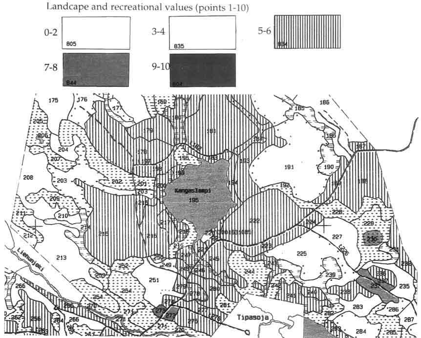
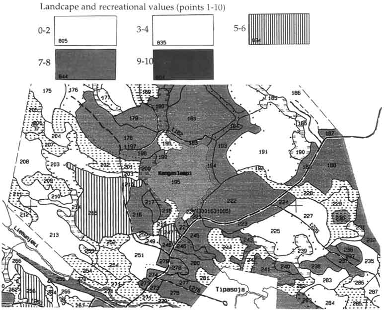
The Finnish Forest and Park Service in the province of Kainuu used the following system in 1995 to evaluate and describe two non-monetary values, landscape and recreational, in state-owned forests. This system is part of the regional planning system and can provide classified information for goal setting in a large-scale forestry. Besides the information on the allocation of wood harvesting sites, these thematic maps (Figures 1 and 2) are a good source of material on forest road planning (FPS documents 1995).
The values of landscapes and recreational attractiveness are evaluated with the models of Dr. Timo Pukkala of the University of Joensuu (Prediction of the amenity of a tree stand, 1988). The basis for the models was a set of DIA-slides. All together 121 people went through 100 scenery slides and evaluated their landscape beauty and recreational attractiveness. The grading varied in the scale between zero (very poor) to ten (superior). The models predict the average opinion of those people.
In addition to those qualitative figures, some quantitative figures were also used. Those figures describe tree stands and site types. The formulas are the following:
Landscape value = 4.471 + 0.06450*dg - 0.0001745N + 0.006439VmD + 0.005733VkD
Recreational attractiveness value = 3.551 + 0.02988tg - 0.0001712N + 0.006600VmD + 0.003783VkD
|
dg |
= |
mean diameter of basal area (cm) |
|
N |
= |
number of trees (number/ha) |
|
Vm |
= |
volume of pine (m3/ha) |
|
Vk |
= |
volume of birch and European aspen (m3/ha) |
|
tg |
= |
age of the stand (yrs) |
|
D |
= |
1 when dominant height > 10 m, in other case D = 0 |
Data processing was done only in the areas where the growth was more than 0.1 m3/ha. Those that were excluded are typically open bogs where one cannot measure tree ages.
In the models it is remarkable to note that Finnish people in general appreciate both mixed stands and stands of deciduous trees. Young stands and pure coniferous stands, especially "dark" spruce stands, are not felt so attractive.
This kind of presentations can be used for planning environmentally sound forest roads. At least the presentation can give hints on which areas or sites should be outlined with special concern to landscape values.
In Figures 1 and 2 it can be noted that the recreational and landscape values are not always the same on each site, but the ranking is quite parallel. The scale is 1:20 000 and the classification is the following:
Figure 1. Values of landscapes
Beauty of landscapes reflects the tones of each era
It is obvious that "optic entity" - visualization or feeling of a landscape - has a different meaning to each individual of the same era. But in the history of mankind there are some similarities in each era as to what constitutes a beautiful landscape. Cultural backgrounds and development phases of societies have had remarkable reflections on social atmospheres and on internal human tones (Kinnunen ed. 1983).
For example, the "general tone" in Finland in the 1920-1930s was functionalism. It can also be referred to as a time of matter-of-factness. Straight lines were appreciated, many things were very rational. This tone is clearly noticeable in the architecture of that time.
One can notice the influence of functionalism at this time: what is rational is also beautiful. It was during this time that the straight line came into Finnish forestry. Compartment lines (and in some cases forest roads) were thought to beautiful when they were as straight as an arrow. This trend of thought carried through the 1950s and later when forest road construction increased. Roads were lined very straight whenever it was possible.
Now in the 1990s it has been noted that landscapes consisting predominantly of rational and functional trends are not considered beautiful any longer. Many say that a new trend of romanticism has started again after an absence of 100 years.
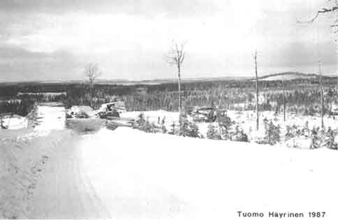
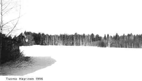
Photo 1 shows a quite typical Northern Karelian landscape during the mid-1980s in large-scale forestry. Very rare was the professional who criticized that kind of landscape, but now after ten years the landscape does not look so good any longer. The tone in landscaping has changed.
A forest road itself is not so often "the big thing" in the landscape, but all the forest operations which follow are more remarkable. Locating and sizing of clear-cut areas are much more dominant in the landscape than the road itself.
This open 1980s-type of landscape (Photo 1) should not be present today in the 1990s for tones and trends have changed. Careful landscaping is nowadays tightly involved both in forest and in road planning.
An example of these new environmental and landscaping attitudes is the guidelines of a manual entitled Forestry Environment Guide (by FPS). It has been launched and implemented by training FPS personnel, from loggers to district managers, from special planners to road building contractors, including everyone in forestry planning and implementation. From the advice contained in these environmental and landscaping guidelines it is possible to see the essential changes in Finnish forestry.
In summary, the beauty of a landscape is reflected in the tones of an era. The foresters of certain eras acquired a sense of what constituted a beautiful landscape from particular tones and trends of that time. It is in accordance with these tones and trends that the foresters have planned, led forest operations and produced landscaping.
Case 2. Check the landscape from many look-out spots
The planning systems in forest management and separately in road planning in a Northern Karelian forest district were at a good Finnish level during the 1980s. The practice went smoothly and road targets were achieved (yield around 320 000 m3, 100 km new 1-3 class roads built annually, total 2000 km network, 165 000 ha forest land). During this time, the field manager of the district (presently the author of this paper) learned a valuable lesson. This information was simple and an essential mean for all road planners.
A planner who explained his medium-range management and working plans presented the lesson. First he showed all the necessary maps and other documents (where to allocate major operations: harvesting, new roads). Secondly, the planner showed the same area in nature from many different look-out spots and different view distances.
This presentation on ground level - with the aid of maps - was much more concrete and illustrative than any other presentation with maps only "from up to down".
After this simple and practical lesson the author of this paper was convinced that the best means to make aesthetically proper landscaping is to "walk, walk and walk in the nature" and observe the landscape thoroughly from different look-out spots and from different distances.
More constraints to traditional forestry
In recent years more accurate constraints have come into traditional forestry. The road planners and, generally, the foresters, have to take in consideration new legislation (discussed in other presentations) and public awareness. This has brought in new dimensions to road-planners' SWOT-analyses: Strengths, Weaknesses, Opportunities and Threats are something else than they were some years ago. In the next case these aspects are discussed.
Case 3. A forest road through a multi-protected estate
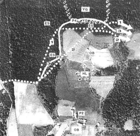
The author of this paper faced a road-planning task, which is quite unusual, but provides "the whole rainbow" of different values which may be faced in traditional forestry as well. In this case the neighbouring estate had the right to build a road through the estate of Pyhäniemi (Figure 3), which had the following protection features:
1. The estate was a heritage landscape (one out of 20 in the provincial lists) (Tahvanainen ed. 1994).2. The estate had been bought for the protection of a very endangered species in the Finnish fauna - the white-backed woodpecker,
3. The 22 buildings or ruins in the estate were in the list of protected old buildings by the Finnish Museum Authority.
In September 1994 the neighbour informed that he was going to build the road. Due to the multi-protection status of the estate, forest road planning had to be carried out very carefully and professionally. Many road building cases through stands of existing or proposed status of protection had been in the headlines of nation-wide newspapers.
According to the law, the cancellation of the right of road (county land surveying office) was not possible. Neither was any alternative major direction possible. After these clarifications the following steps were taken:
1. On the site the writer as well as the planner noticed that the legal outlining for the road was poor both in sense of protection and from a technical point of view of road building.2. The County Counsellor of the Environmental Protection was informed that the existing legal place for the road was inadequate. The Counsellor was well aware of the protection status of the estate and gave the right to outline the road differently than in the documents.
3. The planner put the best effort, used enough time, marked the new outline, documented the plan and let the private road-builder start to open up the 10 m wide and 1.8 km long terrain base.
What happened next was not expected. Some local nature protection activists and the Finnish branch of a world-wide nature protection organization sent to the planner a very strongly flavoured letter stating that irreplaceable mistakes had been done with the new outlining. The argumentation was rather offensive.
All the same the planner felt quite safe and self-confident by answering with the following facts:
1. The Counsellor, who is also a respected Grand Old Man among the bird protectionists (professional author, etc.) had given his approval to the changes.2. The subsequent characteristics were now better than in the right of road or in the previous plan of the birdmen.
HL = heritage landscape, ES = protected stands of endangered species, OB = protected old buildings, YG = young growth
1 = legal right of road, 2 = outlining for specie protection, 3 = the final road
P2 = look-out spot (photo 2), P3 = look-out spot (photo 3), P4 = look-out spot (photo 4)
A. The right of road and previous plans of the birdmen were inadequate because of the following reasons:
· The number of old deciduous trees cut was higher than in the final plan and old decayed birches and decaying fallen trees are necessary for the white-backed woodpecker.· The farming site would be destroyed in certain places.
· The new road would be visible from the edge of the old stand and from the farming site.
· The natural thicket on the stand edge would be destroyed.
· Too many windfalls were to be expected.
· The stonewall formations made by former farmers would be destroyed.
· The new road would be visible from the yard of the old buildings, which was the main look-out spot of the heritage landscape.
· Both alternatives required technically heavier road building than the final plan.
· More new ditches would be needed which would obviously affect the hydrobiological balance of the protected stand.
· More transported material (gravel, culverts. pipes) would be needed.
B. The final plan was proper for the following reasons:
· In the heritage landscape the new road would hidden on the back of the old stand (look-out spot, photo 4).· The farming site and the heritage landscape would not be split, the stonewalls would be protected, and a smaller number of old deciduous trees would be cut (look-out spot, photo 5).
· The outlining would be in the less dense part of the tree stand (look-out spot, photo 6).
· The surrounding of an old barn and a close by a meadow would be saved.
· Fewer new ditches would be needed than in the other alternatives since the sides of the existing main ditches would be used for the road base.
· The road would be lined from the most valuable stand (wet terrain) to the young growth of hard mineral ground (YG, not seen in the 52 years' old aerial photo) as soon as possible (the other alternatives go along the wet land longer).
· Technically this would be the cheapest alternative with the lowest impact.
Besides the planning itself the planner supervised the actual road building to ensure detailed quality of the contractor's work. Some advice was given, but the overall quality of the work was very satisfactory.
After showing the careful preparation of the road plan, the argumentation faded.
Various skills and public participation into landscaping
The lesson of Case 3 and the planning process from the planner's point of view (SWOT-analyses) are
Strengths of the planning process:
1. Enough effort was put into the planning process.
2. All essential documents were studied.
3. Careful site surveys were carried out.
4. The highest provincial environmental authority supported the project.
Weaknesses:
1. The argumentators (the protection activists) did not know all the protection constraints of the estate.2. The argumentators did not have any know-how of road building.
3. The activists (who turned to be the argumentators) did not get involved in the final planning.
Opportunities:
1. To plan and build a road without disturbing nature protection, heritage landscape and other protection values.2. To show that multi-professional skills and overall sensitivity are more essential than expertise in a single subject (e.g. birds) in this kind of planning
Threats:
1. To damage the protection area and get unfavourable national attention.2. To disturb the slowly built peaceful coexistence and understanding between those in charge of forestry/nature protection and voluntary based protection organizations/activists.
In summary, it is worthwhile pointing out that nowadays technical skills are not always enough in road planning. In many cases other authorities and public awareness must be taken into consideration. Road planners and foresters are on the phase to step in to conflict management and public participation.
References
In Finnish (partially in Swedish):
Finnish Forest and Park Service. Different planning and working documents.
Iisakkila, Liisa. 1977. Perustietoa maisemaan vaikuttavista luonnontekijöistä. Espoo. Otakustantamo.
Kinnunen, Aarne & Sepänmaa, Yrjö, eds. 1983. Ympäristöestetiikka. Helsinki. Gaudeamus.
Komiteanmietintö- Kommittebetänkande 1980: 44. 1980. Maisematoimikunnan mietintö, Landskapskommissionens betänkande. Helsinki -Helsingors. Valtion painatuskeskus.
Niemelä, Hannu. 1995. Metsätiet ja metsäluonto. Metsäkeskus Tapion julkaisu 9/1995. Helsinki.
Tahvanainen, Päivi, ed. 1994. Ympäristön tila Mikkelin läänissä. Helsinki. Vesi-ja ympäristöhallitus.
In English:
Finnish Forest and Park Service. Forestry. 1994. Environment guide. Helsinki.
Higuchi, Tadahiko. 1988. The visual and spatial structure of landscapes. Cambridge. The MIT Press.
Sessions, John, ed. 1992. Workshop on computer supported planning of roads and harvesting. Feldafing, Germany. IUFRO and University of Munich
![]()
![]()
![]()