![]()
![]()
![]()
The Part 1 Guidelines gave a menu of alternative options for the management of floodplain fisheries, designed for a range of different spatial management units - VMAs, CMAs and so on. The selection of one or more of these options in a given locality depends on three factors: (1) the objectives of the various policy making agents, from national government down to the community; (2) the state of the fish stocks and the actual need for management; and (3) the practicalities of alternative options, given local ecological conditions and the capacity and resources of management agencies.
Guidelines on the use of the different management tools were provided in the How to manage section of Part 1, in addition to their key advantages and disadvantages. The guidelines do not give cook-book style instructions on exactly how to use each tool, preferring instead to encourage the detailed investigation of local conditions, and the development of an appropriate management plan (a suite of locally-adapted tools) designed to achieve the stated objectives. The fine details of the plan (e.g. the numbers of licenses to be issued, the areas of reserves to set aside etc) may then be clarified by using an adaptive management approach (Part 1). This localised, adaptive style of management is recommended for floodplain fisheries in recognition of their great variability between different locations, and the importance of local environmental and socio-economic conditions on the outcomes achieved.
Many of the management tools recommended in Part 1 require mainly common sense for their initial implementation. Local fishers will know, for example, the approximate likely impacts of alternative closed seasons on the different gears used in the fishery; or which barrier and hoovering gears may potentially over-exploit whitefish and blackfish stocks. They will probably also know which habitats need to be maintained or restored to ensure the access of fish into local waters and their successful spawning. The main challenge to managers of floodplain fisheries is how to decide who may fish, and to find socially acceptable mechanisms for the implementation of those management tools which would involve benefits for fish stocks and some community members (those using certain gears), but also have disbenefits for others.
Reflecting this challenge, this final Management section begins with illustrations of the alternative mechanisms used to control access to fishing rights at the project sites. This is followed by a multi-species, multi-gear modelling analysis which demonstrated the potential trade-offs in benefits which may arise from different management tools in these interactive fisheries.
The use of reserves or ‘refuges’ is increasingly being recommended for fisheries throughout the world as a precautionary measure against excessive exploitation. Reserves are particularly being used in the marine zone, both in open oceans (Shackell and Willison, 1995), and coastal areas (Polunin et al, 1983; Roberts and Polunin, 1991; Dugan and Davis, 1993). Reserves are more rarely used in river systems, but are becoming more common (Pinedo-Vasquez et al, 1992; McGrath et al, 1993). Section 5.3 discusses how reserves may be used in river fisheries in various ways to provide a highly visible, easily understandable and relatively enforceable means of controlling fishing effort, particularly for blackfish resources in the most locally controlled ‘VMA’ units.
The management of hydrologically modified (impounded) floodplains provides particular challenges for management due to the competing demands of agricultural and other sectors. It was shown in Section 3.4 that the PIRDP flood control scheme in Bangladesh limits the access of fish but does not significantly reduce the productive potential of fish inside the scheme. Section 5.4 briefly reaffirms that effective control of sluice gates could allow more fish into flood control schemes. A fish production model adapted to floodplain hyrdology is then demonstrated to show that, where water levels could be maintained by flood control schemes over the dry season, fish survival could potentially be increased, leading to greater spawning, recruitment and catches in the following year.
Finally, this section provides advice on the use of fish stocking for the enhancement of floodplain fisheries, based on the analyses of Project R6494. This approach was recommended in Part 1 particularly for management areas in which the heavy investments required in seed fish could be most effectively recovered.
Floodplain fisheries operate in a highly spatial environment comprised of many different habitat types. Some locations on the floodplain - especially channels along which fish migrate, and waterbodies where they survive the dry season - are potentially much more productive than others. Access to these locations is usually in strong demand by floodplain fishers. To avoid the potential conflicts of open access exploitation with large numbers of fishers, many Asian fisheries have evolved systems for the effective control of access to fishing.
Access control essentially limits the numbers of fishers. This may lead to several benefits, including:
improved economic returns to fishers, due to increased catch-per-unit-effort (since the catch is divided between less fishers);
increased efficiency of exploitation, when catch rates are high enough to justify the use of expensive but highly efficient gears such as barrier traps;
improved sustainability of fish stocks (this may not be guaranteed if fishers still use highly exploitative gears, particularly if they perceive that fish may attempt to emigrate from their waterbodies to other surrounding ones);
reduction of conflicts between fishers; and
collection of revenues (either to the government or to the local community) from those fishers granted access to fishing.
On the other hand, access controls may be seen as unfair by those fishers who are denied access to the fishery, especially where alternative employment opportunities are limited.
This section describes the different access-control systems in use at the project study sites, with comments on their implications for the ecological and socio-economic performance of the fisheries, their perceived equity, and the mobility of fishers. Both formal government-led systems are described and other traditional systems used by communities. Each of the alternative systems are well adapted to local conditions, having clear reasons for their development. No single system may be recommended for universal use, but much may be gained from building on local practices, perhaps by combining them with beneficial features found elsewhere. The implications of alternative approaches should be clearly understood by managers attempting to choose priority objectives for their fisheries.
The spatial licensing of fisheries is used in many Asian waters, including all of the Bangladeshi and Indonesian study sites of projects R4791 and R5953. This section initially describes the licensing systems used at the Bangladesh PIRDP study site and the Indonesian River Lempuing and Jambi sites. The features of the different access control systems are then compared, including their implications for the fishing opportunities and mobility of fishers and on the sustainability of fish stocks.
In Bangladesh, many natural waterbodies are leased as ‘jalkars’ by the Ministry of Land's Revenue Section7. Larger waterbodies ('8ha) are administered by the district level offices, and smaller waterbodies by the thana or union level offices. Man-made canals, in contrast, may be leased more informally by their builders, including the Water Development Board and the Roads and Highways Department of the Ministry of Communication. Some small waterbodies are privately owned, following historical claims, and either leased or fished by their owners. Jalkar and other leases usually run for one year, though some waterbodies are occasionally leased for three year periods.
In leased waterbodies, the leaseholder either fishes the most effective gears himself or sub-leases the rights to fish these gears to other (usually professional) fishermen. Gears in this category may include the stationary lift nets, bag nets and katha, and mobile drag nets and seine nets. For gears taking relatively small catches, fishing in the Pabna region is generally free, reflecting the difficulty of controlling their use, and possibly also the generosity of the leaseholders towards community members operating on low profits margins. Free fishing may also be had on virtually all floodplain waters over the flood season, including lands privately owned for farming during the dry season. This accessibility has resulted in the strong mobility of Bangladeshi fishermen, as discussed in Section 5.1.4.
In the Pabna study site, 14 defined waterbodies are leased as jalkars (Figure 5.1). These jalkar waters include three long sections of the main rivers (approximately two-thirds of all the secondary rivers), 15% of the beels (especially the deeper, permanent beels), and 10% of the canal locations. Floodplain waters are not included in any jalkars in Bangladesh. Fishing in jalkars was at its highest during the dry season months February to June (71% of the gear-days fished by respondents at this time), particularly within the main river jalkars. Other jalkars in respondent's home regions were fished during the drawdown months. Jalkars were least fished during the high flood season (25% of the gear days fished from July to September 1995), when more fishing is done on the unlicensed floodplains. All of the fishing gear categories recorded in 1995 were used both in jalkar waterbodies and in unleased waters, indicating the relatively open access of Bangladeshi leasing units to all types of fishermen.
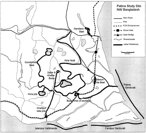
Figure 5.1 Locations of the fourteen licensed ‘jalkar’ waterbodies at the Bangladesh PIRDP study site, licensed for access to fishing by the Bangladesh Government's Ministry of Land (from MRAG, 1997).
The license fees for Bangladeshi jalkars in the project area range from only Tk725 to over Tk150,000 for the largest jalkar in the main river. Total license fees collected at the PIRDP site were Tk201,000 and Tk374,800 respectively in 1995 and '96. Based on a low-season, mean, wholesale fish price of Tk50/kg8, the total fish catches at the PIRDP study site were estimated to have first sale values of approximately Tk95m and Tk108m in 1995 and 1996 respectively. Total government jalkar license fees at the PIRDP site then amount to only 0.21 and 0.35% of total catch values in 1995 and '96 respectively.
A waterbody licensing system was established in the Lempuing River system by the leaders of the Palembang kingdom in 1822, to avoid conflicts developing among fishermen (Depati H. Muh. Rawas, ex-head of Kayuagung marga administration, personal communication, 21 May 1996). In the Lempuing area, the current Indonesian administrative system was introduced in 1983, with the old marga being replaced by a more hierarchical government system. The Lempuing waterbodies defined in 1822 were maintained, however, for licensing by the new administrators, and are still used in today's auctions9.
The waterbody auctions, or lelang, are now held on an annual basis and conducted by the head of each administrative district (kecamatan) under the supervision of Department of Fisheries regional (kabupaten) staff. The Indonesian auctions now appear to be viewed by local administrators mainly as a means of raising revenues. In 1983, the new administrators thus introduced a ‘commodity flow’ tax (usually applied for cars / toll roads) of 15%, on top of the auction fees. Minimum sale prices are also raised deliberately by administrators in some years by a standard percentage, often of 10–15%. Substantial revenues are then raised in the productive Lempuing auctions, and up to 50% of kabupaten incomes may be derived from the licensing of these fisheries.
The Lempuing auctions are open to any bidders, including outside investors, and demand for licenses has traditionally been high. Fishery license fees for Kabupaten Ogan Komering Ilir (OKI, which includes the Lempuing River) rose dramatically by 290% from 1992 to 1996, having shown only gradual increases before that time (Dinas Perikanan Fisheries Service, Kabupaten OKI annual reports, data not presented). Based on a very rough calculation, using an average fish price of Rp1,500/kg, total license fees for Lempuing waterbodies in 1995 and 1996 were estimated to be 8.6 and 15.3% respectively of the total catches in those years. With such high fees, both the numbers of waterbodies licensed and the numbers of fishermen in them have declined in the most recent years (MRAG, 1997). Total license fees for the Lempuing also peaked in 1996 at Rp164.9m (approx. US$30,000), and declined in 1997 to Rp156.1m
In other localities in Indonesia, different systems exist for the management of floodplain river resources, under the traditional leadership of local village communities. Such systems include both spatial licensing components and other mechanisms for ensuring the acceptability of the system to the community members. These systems have been reported in depth by Hoggarth et al, in press (a) and are discussed further in Chapter 7. This section makes a brief comparison of these community-based systems with the government-based licensing and leasing systems described above.
Spatial licensing at villages in Jambi province (case study sites 3–5 in Figure 2.3) was found to be based on a desire to preserve local long-term benefits, rather than to simply raise revenues. Each of the three villages studied in Jambi had smaller floodplain resources than the Lempuing system, but all of the floodplain waterbodies were closely associated with their local village. With such local powers, some of the communities had developed management approaches designed for the long-term sustainability of the resources, and for social gains. Some villages restricted bidding at auctions to village members only, preferring local social benefits over the maximisation of revenues. Other villages used ‘sacred’ reserve waterbodies, sometimes associated with traditional, ceremonial fishing days to ensure some local survival of blackfish stocks. To further avoid over-exploitation, fishers were represented on licensing committees to advise on local resource potentials and the state of stocks. Main river habitats were not protected in any way, though, and local communities clearly perceived their actions as benefitting local resources, especially of blackfish species, rather than the more shared riverine whitefish species (Hoggarth et al, in press (a)).
The details of the licensing systems determine the accessibility of different fishing grounds to fishers, and their spatial behaviour throughout the seasons. Reflecting the different licensing approaches, this section shows that fishers in Bangladesh are far more mobile than those in Indonesia. This mobility (and particularly the regular presence of ‘outsider’ fishers) may create particular challenges for the effective implementation of local management mechanisms.
In the River Lempuing, fishermen pay for licenses to fish in the discrete and defined auction units of the river system. The Lempuing has 35 such fishing units (illustrated as ‘temporary fishing settlements’ in Figure 2.3). These waterbody units, or perairan are sometimes further divided into sub-units for fishing by separate groups of fishermen. Individual fishermen are then sometimes sub-licensed by the groups to fish with certain small gears. At the Lempuing, all these fishermen fish almost exclusively within their own waterbodies (some free fishing is available in January of each year, and in the unlicensed section of the River Lempuing flowing through the main town Pedamaran).
The situation in Bangladesh is in complete contrast to that in Indonesia. Though the larger waterbodies have traditionally been licensed for restricted fishing as ‘jalkars’, many waters, especially over the flood season, are freely available to all. At the PIRDP site, in each of the Adjacent, Inside and Outside study regions, the greatest catches were usually taken by respondents fishing within their own region (Figure 5.2). Such localised fishing was concentrated during the drawdown and early dry seasons (the second half of the year) when fish are most easily caught. Fishermen did, however, also fish outside their own localities: in all four fishing regions, at least some of the catch was taken by fishermen from all three of the other regions of residence (Figure 5.2). Fishermen from both the Inside and Outside regions took significant portions of their catches (26% to 46%) from the Main River habitat, especially over the dry season. At this time, both fish and fishing places are scarce on the floodplain, and many fish (especially Hilsa hilsa shad) are available outside. These results indicate a significant mobility of fishing labour among the four fishing zones in Bangladesh, compared to negligible mobility in Indonesia, where licensees fish only in their own auction units.
Most waterbodies in both Indonesia and Bangladesh are licensed for only one year periods, as preferred by fishermen due to the uncertain profitability of future seasons. Longer licensing periods have been considered for these fisheries to give fishermen a greater incentive to manage their own resources and achieve conservation goals. It is, however, questionable whether such approaches would achieve their objectives in open floodplain waters.
Though Indonesian fishermen hold exclusive rights for fishing within their licensed waterbodies, the behaviour and mobility of fish (see Section 3.2.1) is such that they do not hold exclusive rights to the fish within their waterbodies. In competition with fishermen in other waterbodies, fishermen clearly perceive a strong incentive to catch as much as possible from their waters each year.
No evidence was ever observed in the River Lempuing waterbodies, for example, of fishers exercising any form of restraint over the dry season period.
While long licensing durations may give sustainability benefits for self-contained waterbodies such as ox-bow lakes (Middendorp et al, 1996), it is now seen that they would provide little benefit for the more interactive floodplain waterbodies due to the strong migratory behaviour of floodplain fish species.
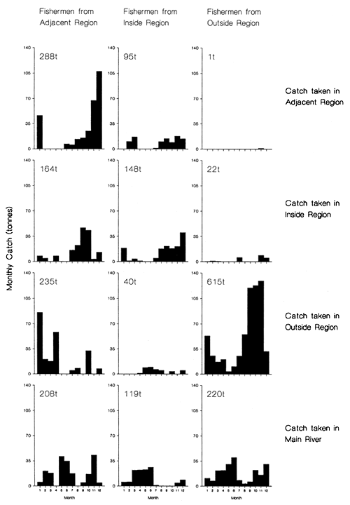
Figure 5.2 Estimated monthly catches (tonnes) during 1995, taken in the four capture regions by fishermen from the three residence regions, at the Bangladesh PIRDP study site (from MRAG, 1997).
Spatial licensing systems are used as the main current management tool at both the Bangladesh and Indonesian study sites, though with subtle local differences. In comparison to floodplain fisheries in both Bangladesh and other Indonesian catchments (see next section), the River Lempuing fishery may be seen as strongly commercially oriented, both from the view of the fishers and the licensing authority. The complete licensing system used in this catchment thus creates opportunities for very high catch rates per fisherman, by keeping the numbers of fishermen low, which in return allow much higher percentages of the catch values to be taken by administrators as licence fees. Such a system may be justified for the extensive River Lempuing catchment, where catches are large and the deeply flooded ‘lake district’ is not associated with any single village. The high licence fees may also be seen as a fair way of distributing resource benefits more widely around the community from the relatively small group of licensed fishermen.
Alternative licensing systems were seen in the other Indonesian fisheries in Jambi. Where waterbodies were closely associated with villages, auctions were still used but steps were taken to ensure that license fees did not become excessive, and reserves and other measures were used to ensure the sustainability of the resources for future users. In Bangladesh, waterbodies appear to be less clearly associated with particular villages and only partial licensing is used for the largest waterbodies. Fishing is then much more freely available, especially over the high water period, and taken advantage of by the poorest fishers, usually using chasing and set-and-wait gears. License fees in Bangladesh are then a small component of the total catch values reflecting the lower marginal benefit of having a license when many opportunities are also available for free fishing. Lower license fees may also be seen as fair in such a fishery, in which the benefits are already widely distributed among the population.
With clear benefits to both fishermen and licensing authorities, it is interesting that the licensing systems are currently under dispute in both countries. Since both systems may be seen as fair, given the variable demands of the two countries, and since they also prevent conflicts between resource users and generate income, it may be recommended that the license systems should be maintained at both sites. However, since neither of the two main license systems provide any conservation incentives, it is also evident that they should be supported with additional measures, as traditionally used in other localities (e.g. in the Jambi villages), and recommended in Part 1.
As described in Chapters 1, 4 and 5, floodplain fisheries are both multi-species and multi-gear in nature. This section is about the ‘technical interactions’ which occur between different floodplain fish species and fishing gears, and the importance of these effects for the management of floodplain fisheries. These issues were particularly studied at the Bangladesh, Thai and Indonesian study sites of Project R4791, as reported by Hoggarth and Utomo (1994); Hoggarth and Kirkwood (1996) and Hoggarth (1994).
These studies modelled the effects of four management strategies - effort limitations, closed seasons, mesh size increases and gear bans - on the catches of different species in different gear types. Due to the strong technical interactions between the gears, it was predicted that the management strategies would give substantial re-allocations of yields between gear types. However, due to the balance of benefits to some gears and losses to others, no overall gains were achieved from any of the scenarios. Such management tools should thus be used mainly to redirect benefits to preferred gear categories, rather than to attempt to increase overall yields.
Sensitivity tests were carried out on these management predictions by using alternative inputs for model parameters. Model predictions for closed seasons and gear bans were found to be robust and uncomplicated, confirming that they could be qualitatively anticipated for other sites from simple information on catches by gear type and species. As might have been expected, closed seasons benefit those gears which are most used in the seasons which are not closed; gear bans benefit those gears which competed with the banned gear for the same fish species! These simple results argue for a common sense approach to the assessment of floodplain fisheries management options, as recommended in Part 1.
A technical interaction may be defined as “competition between two fishing gears over a unit stock of one or more species of fish”. Depending on their mesh sizes and selectivities, two gears may either compete directly, catching fish at the same time and place, or sequentially, with one gear reducing the potential catches taken later by the other gear. Such interactions are associated with fishing gears, and contrast with purely ‘biological interactions’ between fish species, such as competition for food or predation. Technical interactions are far easier to study than biological ones (Hilborn and Walters, 1992) and multigear fishery models are now common stock assessment tools (see e.g. Daan and Sissenwine, 1991). Technical interactions are particularly strong in floodplain river fisheries, due to the strongly seasonal use and effectiveness of different gears (see Section 4.2).
The existence of technical interactions at the study Indonesian River Lempuing study site may be clearly seen in the length frequency data collected by project R4791 (see Hoggarth and Utomo, 1994). These data showed that the catches of two species, Notopterus notopterus and Helostoma temminckii are comprised of more than one age class (Figure 5.3). The clear bimodalities in their distributions show that both species survive the dry season in large enough numbers to support significant fish catches in their second year of life. Each species is exploited by different gear types as they grow to larger sizes, and as the seasons pass.
Both species are assumed to spawn mainly at the beginning of each flood in approximately November of each year. Small putak, N. notopterus then first appear in small numbers among the rod and line catches from the lebak in April. Young putak then form the main catches of the large tuguk, empang and ngesek gears fished in June, July and August. Putak are also caught by the individual fishermen both in August as small fish and then next year as larger one year old fish from both hooks and portable traps. These results show that the availability of putak to the large-meshed traps and hooks of the individual fishermen is limited by the much smaller-meshed tuguks, empangs and ngeseks of the group fishers (the mesh sizes of the different gears are given in Table 4.2).
Tembakan, Helostoma temminckii are the third most common species caught in the River Lempuing, being taken in all the trap gears in the lebak and the riverine habitats. Like putak, they are first caught in large numbers as young fish in the small-meshed, large gears at the end of their first growth season on the floodplain (Figure 5.3). Very few are caught at this age by the larger meshed traps and gill nets of the individual fishermen, who take most of their fish in the next year's high water (January/April). This conclusion assumes that the unimodal distributions early in the year, compared to the later bimodal catches, indicate that the youngest fish are too small to be caught at this time. Tembakan aged around 19–20 months then have a second period of vulnerability to the empangs and ngeseks resulting in the second mode in the sampled length frequencies (Figure 5.3). Clearly, the availability of both tembakan and putak to large-meshed and late-season fishing gears, depends strongly on the catches taken either earlier in the year, or by smaller meshed gear types.
As illustrated above, technical interactions between different fishing gears are partly determined by their mesh sizes and seasonalities. They are also determined by the species which they catch - if empang traps did not catch putak for example, they would not compete with the subsequent rod-and-line fishery, at least for that species. Certain gears are more specific than others, and many of the smaller gears such as fish traps and hooks are strongly targeted at individual ‘guilds’ of fish (see e.g. Figure 5.4 for the River Lempuing). Other gears such as the barriers and seines in Indonesia (Figure 5.4) and the gill nets in Bangladesh and Thailand are less specific and take virtually any species they can intercept (MRAG, 1994). With the various gears catching the same fish both within and between the different seasons, it is clear that both direct and sequential technical interactions are likely to be pronounced in these fisheries.
BEAM4 methodology
The importance of these technical interactions for the management of floodplain fisheries was investigated using FAO's ‘BEAM4’ methodology (Sparre and Willmann, 1991; Hoggarth and Kirkwood, 1996). BEAM4 is a cohort based, multispecies, multigear simulation model using standard equations for exponential mortalities and von Bertalanffy growth. Each species in the model is assigned its own biological parameters (K, L?, t0, Z and M in standard notation), and each gear type is assigned a specified selectivity ogive for each species, determined approximately from the length frequency data. The seasonality of the fisheries is modelled by inputting the actual monthly fishing efforts of each gear. The number of recruits and the gear/species catchability coefficients are then tuned to give the best possible approximation to the observed catches. Such a model is capable of detailed outputs on the seasonal patterns of catches of each species by each gear type (MRAG, 1994). Since recruitment is assumed to be constant, regardless of mortality rates, BEAM4 is equivalent to a multispecies, multi-gear ‘yield-per-recruit’ model.
Floodplain fish species are highly variable in terms of their maximum sizes, reproductive behaviours, feeding preferences and migration patterns (see Section 3.2). The vulnerability of different fish to different gear types is particularly determined by the latter two characteristics.
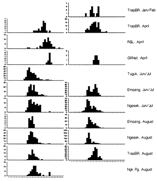
Figure 5.3 Length frequencies of Notopterus notopterus (left) and Helostoma temminckii (right), taken from six different commercial gear types during four sampling periods, in 1993, from the River Lempuing in Indonesia (length scale from 1 to 35cm; TrapBR = combined bamboo and rattan traps, R&L = single hooks fished on rod and lines, Ngk Pg = ngesek pinggiran - see gear descriptions in Table 4.2; from Hoggarth and Utomo, 1994).
For the BEAM4 modelling, each species was assigned to one of five or less fish ‘guilds’ on the basis of its biological characteristics and gear vulnerability. Approximate biological parameters were assigned to each guild, based on the results of the length-frequency sampling programme. A slightly different selection of guilds was used at each site, reflecting the dominance of different species in the catches. All the sites contain similar guilds of large predators (mostly snakeheads including Channa striatus), medium-sized blackfish (eg Notopterus notopterus), Anabas testudineus and Clarias spp) and medium-sized or small whitefish (eg Puntius spp, Rasbora spp). The Bangladesh model included a separate guild of the large major carps including Labeo rohita and Catla catla, and the Indonesian model included a separate guild of riverine predators, particularly the catfish Mystus nemurus. Shrimps are common catches at all three sites, but the Bangladesh fishery takes small Palaemon species while the Indonesian fishery has access to the much larger Macrobrachium rosenbergii. Input growth rates (von Bertalanffy Ks) and natural mortality rates (Ms) ranged from 0.3 and 0.6 respectively for the guild of the largest major carps in Bangladesh, to 0.5–0.7 and 0.9–1.5 for medium sized fish, and up to 3.0 for the guild of the smallest shrimps. An average annual fishing mortality rate of F = 2.0 was entered for most guilds as the average difference of Z-M.
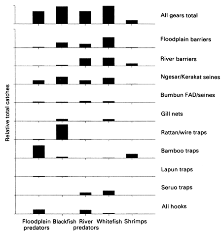
Figure 5.4 Comparison of the total catches of five fish species guilds by the ten most important gear types at the River Lempuing study site (see Section 4.1 and Table 4.2 for gear descriptions; from Hoggarth and Kirkwood, 1996).
BEAM4 results
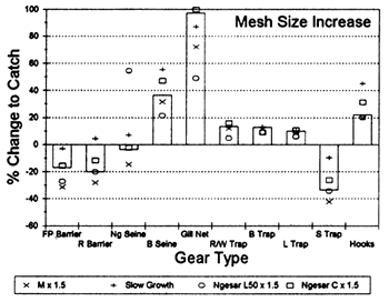
The effects of the four management scenarios on each gear type at each site are illustrated in Figure 5.5, as predicted by BEAM4. In terms of the total yield from these fisheries, none of the management strategies investigated would either increase the catches by more than 6%, or alternatively decrease them by more than 22%. While total yields are thus very insensitive to management, the impacts on the catches of individual gears can be much more pronounced: the average change to catches of individual gears is 22% while the catches of certain gears are more than doubled by the different management strategies. The greatest benefits are available for those gears which presently exploit fish either late in the year, or with large mesh sizes. The greatest management potential for these highly interactive fisheries is thus in the re-allocation of fish catches towards target fishing gears. The relative effects of the different management strategies at each study site depend on the mesh sizes and seasonalities of their most important gears (see details in Hoggarth and Kirkwood, 1996).
Management implications of BEAM4 predictions
Without raising overall yields, the distributive effects of these management scenarios may still alleviate poverty among fishermen, if the gears used by poorer fishermen are the ones which benefit. In the Hail Haor study site in Bangladesh, an analysis of ‘wealth points’ showed that the brushpile seine is particularly used by richer fishermen: this gear is used in the dry season to catch the large major carps and is expensive to build and to fish. The gears used by the poorer fishermen include seine nets (fished in open water without the high access fees and costs of the brushpiles), push nets and large (‘L’) hooks (Figure 5.5). Unfortunately, all four management scenarios in Bangladesh would benefit the brushpile traps far more than these gears of the poorer fishermen (Figure 5.5). The high water closed season would especially benefit the brushpiles and the dewatering gears used in the drought. A reduction in overall effort would increase the catches of larger fish (mostly by brushpiles and large hooks) but reduce the catches of the smaller fish taken by seines and pushnets. A ban on gill nets is already in force in certain parts of Bangladesh to ensure that stocked carps are not caught until the brushpile fishery begins. This analysis confirms that the brushpile catches should be almost doubled by this measure, but shows that the other gears of the poorer fishermen benefit far less (and the gill net fishermen, of course, are strongly disadvantaged). Similar results may be seen for the other fisheries in Thailand and Indonesia (see Hoggarth, 1994).
It is possible that other management approaches, such as banning brushpiles, or all dry season fishing in Bangladesh, could benefit the poorer fishermen. In reality, however, the complexity of social structures regulating access to fishing rights might offset the anticipated benefits. The poorer sub-licensees in Bangladesh and the individual fishermen in the Lempuing often only gain access to fishing rights by the patronage of the richer leaseholders above them. Any benefits they are perceived to gain by policy changes could thus be lost by increases in the tolls they are charged to fish. The redistribution of yield from the richer to the poorer fishermen may, therefore, not be attainable without significant changes to the social structures of these communities, particularly the access to credit among poorer fishermen. To alleviate poverty in these communities, it may be more profitable to develop alternative employment opportunities than to search for restrictive management strategies which would be difficult to implement and may have little real benefit.
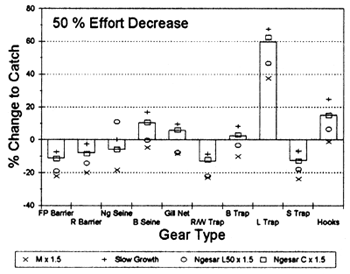
The parameters used in the BEAM4 models were estimated from the length frequency data with low precision, and averaged to cover several species grouped as fish ‘guilds’. To investigate the validity of these predictions, their sensitivity was tested on the model for the Lempuing site. Alternative values were used for two biological inputs: natural mortality rates and growth rates, and for two gear-based inputs: selectivities and observed catches. The observed catches determine the importance of each gear in the model, but may be inaccurate if sampling is poor, or if the catches of certain gears are deliberately misreported. Confidence intervals were not available for most of the input parameters due to the simple assessment methods used. Sensitivity tests were thus performed with mortality, selectivity and catch parameters changed by a standard 50%, as an upper limit to the likely level of uncertainty. Tests for slower growth rates, however, have been made by multiplying K and L? by 0.65 and 1.35 respectively, based on the goodness of fit scores from the ELEFAN length frequency fitting method.
The percentage changes to the catches caused by applying the management scenarios in the Lempuing model with the alternative plausible inputs are shown in Figure 5.6. The mostly small effects caused by a 50% effort decrease are shown to be least robust, particularly for changes in M, as may be expected. The effects of mesh size increases are also predictably sensitive to growth rates, and particularly to the selectivity (1.50) as tested on the ngesar gear.
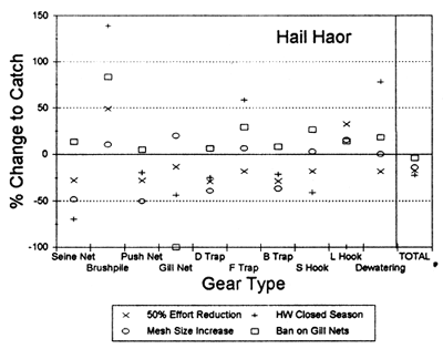
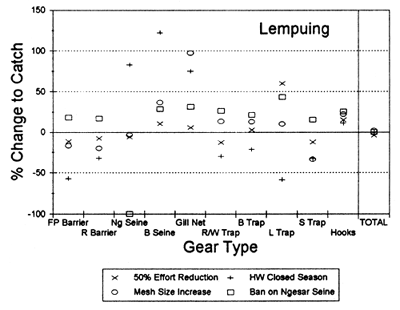
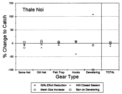
Figure 5.5 BEAM4 predictions on the % changes in the catches of different gear types caused by the four management scenarios (symbols, as denoted in legends) at the three R4791 study sites (from Hoggarth, 1994).
The model predictions for the high water closed season and the ngesar gear closure, in contrast, are robust to all the tested inputs (Figure 5.6). The effects of closed seasons presumably depend more on the seasonalities of the different gear types, than on the parameters tested. The closure of a gear in BEAM4 can only either benefit, or have no effect on, the other gears, depending on whether or not they compete for the same species. As shown in Figure 5.6, the most influential input in this case is the present catch size of the gear being banned; if the ngesar fishery took 50% more of the present catches than estimated, its closure would benefit the other gears far more.
 |  |
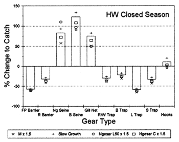 | 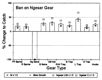 |
Figure 5.6 Sensitivity of the BEAM4 model predictions for the Lempuing fishery, as indicated by the % changes to the catches of each gear type in the base model (bars), and with four altered inputs (symbols, as denoted in legends, with M = natural mortality, L50 = length at 50% selectivity, C = observed catch; from Hoggarth, 1994).
The sensitivity tests have shown that the predicted impacts of closed seasons and gear bans in these fisheries are more robust to the uncertainties studied than they are for the other two management strategies. The impacts of these strategies are uncomplicated; a closed season will thus be harmful to those gears which are most effective at the time of the proposed closure, but beneficial to those which are effective at other times; a gear ban would disadvantage the fishermen using that gear, but benefit any other gears which compete with it for the same types of fish. Bearing in mind the substantial experience and time required to estimate growth and mortality rate inputs needed by BEAM4, it is suggested that the effects of these uncomplicated strategies could be qualitatively predicted for other floodplain fisheries from much more basic information. This would include the relative catches of each species by each gear type - an ‘interaction matrix’ - and the seasonalities of the fishing gears as obtained from basic catch/effort sampling programmes. A tool such as BEAM4 will remain useful to quantify more complex interactions and optimise recommendations, but, as shown in the previous section, an understanding of the social structure of the fishery is likely to be more important than a fully quantitative but still possibly imprecise prediction.
Reserves may be used in various ways for the management of natural resources. Some river reserves are now established on vast scales, such as the 11,000km2 Projeto Mamiraua national park reserve in central Amazonia, and the 800km2 Danau Sentarum forest reserve on the River Kapuas lake district in West Kalimantan, both partially supported by DFID (ODA) funding. Such approaches are expensive but provide the maximum conservation value to the most threatened species within a single catchment area. At both sites, traditional fishermen are encouraged to continue exploitation at sustainable rates, while acting as guardians of the resource.
Reserves may also be used on a much smaller scale, and for the deliberate purpose of enhancing fisheries. Enhancement may either be achieved by increasing the production of larvae and recruits, or by optimising exploitation rates on the overall stocks. In theory, little overall gains are possible in ‘yield-per-recruit’, but substantial gains may be achieved in ‘spawning-stock-biomass-per-recruit’, with potential increases in recruitment and stock stability (Polacheck, 1990).
To protect spawning capacity and maximise recruitment, reserves should be located in areas of critical life cycle phases, especially over the high-mortality dry season period, when fish are maturing in advance of flood season spawning. It is with this objective that reserves are recommended by this research within dry season waterbodies of floodplain habitats. Restraints on fishing activities towards the end of the dry season, which would reduce catches by only a few tonnes, could potentially increase recruitment levels substantially for the forthcoming season. Furthermore, since dry season restraint and year-round reserves are already used as traditional management measures in some Indonesian communities (in Jambi and West Kalimantan), it is evident that reserves are an acceptable means of management in these societies, which would not have persisted without some benefits.
The empirical benefits of year-round reserves have been reviewed for relatively simple coastal areas by both Roberts and Polunin (1991) and Dugan and Davis (1993): gains due to reserves have been observed in some cases in both fish abundances and sizes. The potential of reserves for fish catches (allowing that some fish become unaccessible to the fishery in the reserve) depend on the reproductive output of the protected stock and the resulting recruitment to surrounding areas. The potential benefits to outside fisheries depend largely on the ‘transport rates’ of fish between the reserve and the fishery (Polacheck, 1990; Carr and Reed, 1993; DeMartini, 1993). Fish with minimal transport rates (mobility) are thus likely to be highly protected by a reserve, but to provide no benefits to outside fishermen. Conversely, fish with high mobilities may not be protected by small reserves because their migrations take them too frequently into exploited areas. Fish with intermediate mobilities show the greatest potential to produce benefits for fisheries outside.
At the project sites, fish have been observed with both low and high levels of mobility. It is clear that year-round reserves would do little to conserve floodplain fisheries, except for the most resident blackfish species, unless applied on a large scale (as for example at Mamiraua and Danau Sentarum) to provide full protection to all life history stages (McDowall, 1984).
While year-round reserves may not be justifiable in fishing areas, temporary restrictions over the dry season may be recommended both to ensure that some fish do survive, and to enhance the next year's catches. The potential increases in reproductive output of fish in reserved dry season waterbodies has been shown to be high in Bangladesh floodplains from the ratio of natural and fishing mortality rates. The distributions of new recruits from such waterbodies is also a natural process following the waters of the new flood. At an intuitive level, reserves are therefore recommended for dry season waterbodies of floodplain rivers both to protect spawning stocks for precautionary conservation, and potentially to enhance floodplain catches due to increases in recruitment.
The absolute numbers or areas of reserves required for floodplain resources has not been investigated in this project, nor by other workers, due to the complexities of the multispecies, multi-habitat floodplain resources. In general, however, the optimum design for reserves depend on transport rates and the objectives of the reserve. For recruitment enhancement of fish with relatively low mobility, many small reserves are recommended by Polacheck (1990) for their high boundary to area ratios, giving the maximum possible output. When conservation is the objective, one large reserve may give better protection than many small ones (Diamond, 1975; Picket and Thompson, 1978; Shafer, 1990). For practical and social reasons in floodplain resources, it is recommended that many small dry season reserves would be most likely to produce significant enhancements of fish stocks. Since the fisheries are strongly interceptory, and blackfish mobilities were usually not observed over a few kilometres, it is concluded that reserves would only ‘seed’ surrounding areas up to a small distance away from them. As an initial recommendation, reserves at least every 5km or so would probably be worthwhile.
For social reasons, since both fish and fishermen are mobile on floodplain waters of Bangladesh, it would also be most equitable for all communities to contribute in some way to the reserved dry season stock. With a recognised programme of ‘local action for national benefits’, more communities would be likely to consider sacrificing some of their dry season catches (knowing that some of their fish would migrate to adjacent villages next year), if they knew that their actions were being complemented by equivalent actions (and return recruitments next year) from other nearby villages. Unilateral declaration of reserves would provide some benefits to local fishermen but would, no doubt, also attract fishermen in from other surrounding areas, if catches were seen to be improved.
The optimum locations for dry season reserves are obviously in waterbodies where fish are known to survive over the dry season, and also from which fish subsequently distribute into the exploited stock in the following year. In Bangladesh, the larger perennial beels and river sections have been identified as key survival habitats, both inside and outside the PIRDP embankment (Section 3.2.5). In Indonesia, the wider downstream Savanna river sections provide higher survival than the upstream Forest river, the large waterbodies in the Lake district also allow good survival. Interaction between the lake and river habitats is limited to a subset of the fish community, however. The existing Fisheries Service year-round reserve at Teluk Rasau in the Lake region (Figure 2.3) may thus provide conservation and enhancement of species such as H. temmincki and O. hasselti, but probably gives little gains for other whitefish species. Additional reserve waterbodies are thus also recommended in riverine habitats, particularly in the downstream areas. In general, due to the habitat preferences of different species, and their variable migrations and distributions across catchments, dry season reserves should be implemented in several different perennial waterbodies throughout the catchment. A catchment with only a single reserve waterbody - even a large one - is unlikely to achieve benefits across its full area.
Flood control schemes such as the PIRDP may give significant social and agricultural gains while also giving negative impacts on fish stocks. The PIRDP appears to have reduced fish productivity by limiting the accessibility of migrant fish. Though fish numbers are reduced, the inherent capacity of floodplains inside the flood control scheme remains high for those fish actually present. Measures are therefore recommended in this section to maximise the recruitment of fish inside flood control schemes to make best use of their productive potential.
It was shown in Section 3.4.2 that fish have strong migratory tendencies to enter the PIRDP, and are able to pass through both large and small sluice gates. The biodiversity of fish stocks inside the PIRDP was also implied to be largely maintained by the entry of fish from outside waters. Fish were found to enter the PIRDP both passively at the start of the flood and also actively at the start of the ebb season. The latter fish were presumed to be mistakenly entering flood control schemes due to their positive attraction for flowing waters, while attempting to migrate upstream towards spawning grounds further up the catchment (Halls et al, in press (b)). Such migratory behaviour creates opportunities for the natural enhancement of modified floodplain fisheries by appropriate sluice gate management procedures. Maximising the entry of major carps during the early ebb active immigration phase would increase the unit value of the ‘inside’ fish community. Allowing additional fish to enter flood control schemes should also be supported by additional survival locations inside, in the form of dry season reserves.
The tendencies of fish to enter the PIRDP could presumably be encouraged by particular modes of operation of the sluice gates to allow fish entry. Such modes have not been determined by this project beyond the obvious conclusion that fish only pass through the gates when they are open rather than closed. Catches in 1996 were thus raised in the PIRDP when the sluice gates were open. Fish larvae and fry were shown by FAP 17 (1994b) to be available in main rivers outside the PIRDP at highest densities just below the water surface. Since both the large and small sluice gates at Talimnagar are of ‘undershot’ design, this may restrict the entry of some fry. Other fish, including some of the larger tagged specimens are clearly able to penetrate such sluice gates. Further studies are recommended on optimum strategies for the management of sluice gates for fish accessibility (see also FDL, 1992).
The PIRDP sluice gates are currently managed purely for the purpose of maintaining water levels for agricultural production. Sluice gate management committees do not include any voice from the fishing communities, but sluice gates are sometimes opened unofficially with or without the permission of the Water Development Board, in response to requests from fishermen. At the study site, the unattended Baulikhola sluice gate was also opened by fishermen in 1995, without the knowledge of the WDB. To improve this situation, the placement of a representative of the fishing community in the management committee for the sluice gates would be a significant first step to recognising their additional potential for fishery enhancement.
While significant gains may be achieved, it must also be recognised that sluice gates could not be opened permanently due to their function as flood protection devices. During the 1995 flood, the sluice gates were mostly kept shut because local rainfall had already raised inside water levels to a point where extra waters from outside could have threatened rice production. In years where water levels are less threatening to crops, requests could be made by the fishermen's representative to open the sluice gates, particularly at times when maximum fry numbers were observed in outside waters, e.g. in the catches of lift nets and savar carp fry nets.
The importance of hydrological conditions on the dynamics, production and catchability of floodplain fish has been well recognised since as early as 1910 (see Welcomme 1985 for review). Numerous attempts (with varying degrees of success) have been made to simulate these effects on catch using simple and multiple linear models relating annual catch in a given year to some hydrological variable or flood index (FI) in the same or previous years. However, inter-correlation among flood indices (eg between flooding intensity and severity of drawdown) can diminish the utility of these types of models for predicting the effects of hydrological modification or manipulation.
In support of the PIRDP impact assessment studies (Section 3.4), Halls (1998) developed a more flexible floodplain fisheries simulation model (FPFMODEL) to explore further the effects of hydrology and hydrological modification on floodplain fisheries productivity building on the work of Welcomme and Hagborg (1977). Similar to the model of Welcomme and Hagborg (1977), the FPFMODEL also describes the dynamics of a single species or a group of species having common characteristics in which growth and natural mortality rates and recruitment are assumed to be density-dependent. The model is also based upon the same weekly iterative interaction of water height (and therefore the area and volume of water upon the floodplain) and exploitation, with a fish population (Figure 5.7).
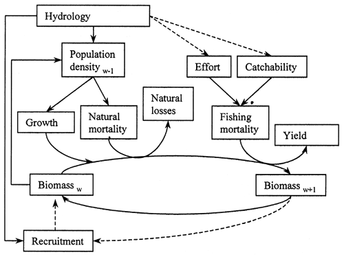
Figure 5.7 Schematic representation of the FPFMODEL showing the process by which the biomass in week w becomes the biomass in the following week w+1. The weekly process is repeated for the 52 weeks of the year, after which recruitment is added in week 52. The process is then repeated iteratively over several years until equilibrium is reached. Solid lines indicate direct influences or operations and broken lines indicate indirect influences or occasional operations (adapted from Welcomme and Hagborg 1977).
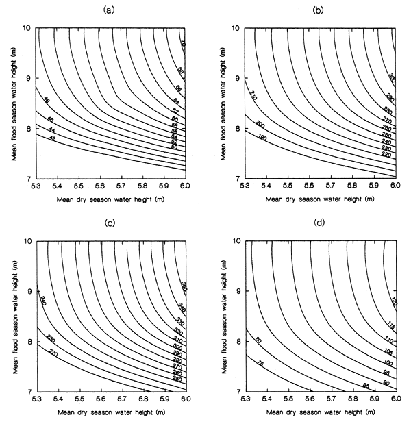
Figure 5.8 Contour plots of equilibrium yield (t) for P. sophore at the PIRDP generated by the FPFMODEL for different combinations of mean flood and dry season water height and for a range of fishing mortality, F rates (a) F = 0.2; (b) F = 1; (c) F = 2; (d)F = 3. (from Halls 1998).
The main differences between the two models concerns the specification of the sub-models describing hydrology, growth, recruitment and mortality (see Halls 1998 for further details). The strength of the FPFMODEL lies in its simplicity, generality and flexibility. It may, for example, be easily modified to include other species (without interaction), analogous to the BEAM4 model of Sparre and Willman (1991). No doubt as more tropical floodplain-river systems become modified by hydraulic engineering, this type of simulation model will become increasingly pertinent to multi-sectoral planning and management.
The FPFMODEL simulations indicate that floodplain fish production (and yield) is most strongly dependent upon recruitment and therefore on the (density-dependent) survival of the spawning stock. The survival of the spawning stock is most sensitive to the hydrological conditions during the drawdown and dry-season period when fish densities are at their highest, although flood season hydrological conditions become increasingly important with increasing dry season water heights (Figure 5.8). These predictions are consistent with those of Welcomme and Hagborg (1977) and suggest that: (i) yield can be taken under various combinations of high and low water regimes, and, therefore, (ii) the loss of yield associated with hydrological modifications during the flood season may be compensated by maintaining greater dry season water heights, and (iii) the most important measure for increasing yield is the retention of the maximum possible water height during the dry season.
![]()
![]()
![]()