


Christoph Kleinn is Head of the Statistics Subunit, Tropical Agriculture Research and Higher Education Center (CATIE), Turrialba, Costa Rica, and is Technical Coordinator of a project funded by the European Union on the assessment of tree resources outside forests.
Definitions and survey options for large-area inventory and assessment of trees outside forests.
Trees outside forests (TOF) comprise tree formations ranging from single discrete trees to systematically managed trees in agroforestry systems. At the latter end of the spectrum they serve a number of ecological and economic functions which may be similar to those of forests in principle although different in extent. TOF are little recognized in natural resources assessments, particularly for large areas, and it is only recently that this topic has emerged as a significant research issue.
This article deals with the inventory and assessment of TOF - inventory being the process of finding out quantitatively and qualitatively how much of a resource there is, and assessment the process of putting the inventory data into a context and assigning values to the resource. The focus is on inventories for large areas such as provinces, countries or regions, as opposed to the more common studies for smaller areas such as farms or groups of farms. After discussing definition and classification of TOF, the article outlines survey options. Particular reference is made to experiences and examples from Latin America.
A clear definition of the resource to be inventoried is always required in order to guarantee consistency and comparability with other studies and to make sure that the results can be communicated easily. FAO defines TOF as "trees on land not defined as forest and other wooded land" (Finnish Forest Research Institute, 1996; FAO, 1998). Thus the definition of TOF depends on the definition of forest and other wooded land. FAO definitions for tree, forest and wooded land and TOF (Finnish Forest Research Institute, 1996; FAO, 1998) are summarized in the Box.
|
Definitions FAO has defined the category of "Trees outside forests" in reference to trees and tree systems occupying lands other than those defined as "forests and other wooded lands". The relevant FAO definitions are as follows: Tree A woody perennial with a single main stem, or in the case of coppice with several stems, having a more or less definite crown. Includes: bamboos, palms and other plants meeting the above criterion. Forest Land with tree crown cover (or equivalent stocking level) of more than 10 percent and area of more than 0.5 hectares (ha). The trees should be able to reach a minimum height of 5 m at maturity in situ. May consist either of closed forest formations where trees of various storeys and undergrowth cover a high proportion of the ground; or open forest formations with a continuous vegetation cover in which tree crown cover exceeds 10 percent. Young natural stands and all plantations established for forestry purposes which have yet to reach a crown density of 10 percent or tree height of 5 m are included under forest, as are areas normally forming part of the forest area which are temporarily unstocked as a result of human intervention or natural causes but which are expected to revert to forest. Includes: forest nurseries and seed orchards that constitute an integral part of the forest; forest roads, cleared tracts, firebreaks and other small open areas; forest in national parks, nature reserves and other protected areas such as those of specific scientific, historical, cultural or spiritual interest; windbreaks and shelterbelts of trees with an area of more than 0.5 ha and width of more than 20 m; plantations primarily used for forestry purposes, including rubberwood plantations and cork oak stands. Other wooded land Land either with a crown cover (or equivalent stocking level) of 5 to 10 percent of trees able to reach a height of 5 m at maturity in situ; or a crown cover (or equivalent stocking level) of more than 10 percent of trees not able to reach a height of 5 m at maturity in situ (e.g. dwarf or stunted trees); or with shrub or bush cover of more than 10 percent. Trees outside the forest Trees on land not defined as forest and other wooded land. Includes: trees on land that fulfils the requirements of forest and other wooded land except that the area is less than 0.5 ha; trees able to reach a height of at least 5 m at maturity in situ where the stocking level is below 5 percent; trees not able to reach a height of 5 m at maturity in situ where the stocking level is below 20 percent; scattered trees in permanent meadows and pastures; permanent tree crops such as fruit-trees and coconuts; trees in parks and gardens, around buildings and in lines along streets, roads, railways, rivers, streams and canals; trees in shelterbelts of less than 20 m width and 0.5 ha area. |
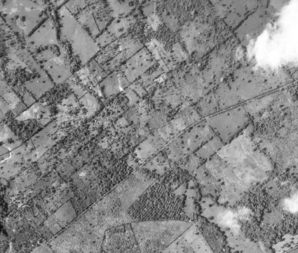
Since the definition of TOF depends on the definition of forest and other wooded land, different definitions will affect the evaluation of how many there are in a region. The extent to which the results vary with different definitions depends on factors such as the spatial arrangement of trees and forest patches (Kleinn, 1991), the precision of the data and the land use practices. Delineation of the boundaries is difficult in many cases (as exemplified by the difficulty of separating forest and non-forest in the Photo). Most forest definitions do not clearly define how to draw the border between forest and non-forest.
Aerial view of different TOF configurations: a tree-covered but almost non-forested landscape
- CATIE
The development of a classification system for the highly diverse TOF resource is expected to remain a main TOF issue in the near future. Such a classification is primarily needed for the better understanding of the structure and composition of the resource. It thus facilitates evaluation of the resource and comparison among different TOF studies. A formal classification system is particularly necessary to enable presentation in maps, where for large areas not every single tree can be depicted.
Comprehensive classification schemes have been elaborated in agroforestry (for example Nair, 1987; Sinclair, 1999), but there is not yet any classification system that embraces all TOF. A key question is whether TOF constitute an area (i.e. are geometrically defined) or whether, because of disaggregation, the resource must be described in other ways, such as biomass per unit of area in agricultural land. Both options are valid and allow map representations of the resource that are useful for different purposes.
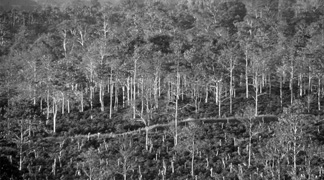
In classifying TOF and the land where TOF are found, one of the main difficulties is that both land cover (biophysical: how much of the land is covered by tree crowns?) and land use (socio-economic: is the land used mainly for forestry?) should be taken into account. There are plenty of possibilities for confusion. Many cacao plantations, coffee fields and pastures, for example, would qualify as forest if classified according to their tree cover. Another example is shown in the Photo: it is not easy to decide whether the image shows a timber plantation (forest) or a fruit-tree orchard (TOF). Whether this distinction can be made depends on the knowledge of the area and the information sources available. Moreover, in their early years timber plantations are occasionally used as pasture, temporarily mixing forestry and other land uses.
For a large-area inventory, classification must be practical above all, so that clear and consistent decisions can be made using the data sources available. Two general criteria are considered useful (see the Box for examples):
- the land use where TOF are found;
- the geometry of the resource.
Examples of classifications of TOF
According to geometryLittle or no direct intertree interactions:
Zoned, exhibiting a more or less clear shape (Sinclair, 1999):
|
Of course, the two criteria are not mutually exclusive but can and should be incorporated into a single classification system, with one or the other considered the principal criterion, depending on the information requirements.
Along with the attempt to design a TOF classification system, a major current issue is the development of a list of attributes that characterize the resource (trees) physically and functionally, as well as the land where the resource is found, so that classification can be done according to the requirements of the particular inventory.
- E. SOMARRIBA
Natural resources assessments are expensive and therefore require an objective justification, which usually embraces the economic and ecological role of the resource, the potential use of the information and the potential users of the information.
Considerable overlap is found between the economic and ecological functions of forest trees and of TOF: both forest and non-forest trees provide wood and non-wood products, living space for animals and plants and thus a role in species conservation, protection of soil and water resources, contributions to the scenic beauty of the landscape and carbon storage functions. Of course, non-forest and forest differ in the degree to which the different functions are present, and many ecosystem functions are specific to the forest and cannot be provided by TOF.
But it is also instructive to look at TOF without making the direct comparison to forest trees. The TOF resource is often independent of the forest, forming a relevant component of non-forest landscape that should be taken into account in large-area natural resources planning, from both an ecological and an economic point of view.
In some countries (for example, Colombia and Costa Rica), forest legislation also extends to TOF (e.g. as regards felling permits). While there is some tradition and experience in, as well as a recognized need for, sustainable management of forests, little is known about the dynamics of the tree resource outside forests. Data are therefore important as a foundation for developing management options to help sustain tree cover. They are also useful for planning, e.g. of wood production from TOF.
In Central America, as a case in point, large-area information on TOF is wanted to respond to the following questions:
- What is the role of TOF in the context of carbon sequestration?
- What is the role of TOF in the context of conservation of biodiversity and the implementation of biocorridors?
- To what extent do TOF contribute to soil conservation, water protection and erosion control, particularly on cultivated slopes?
- What is the role of TOF in the context of timber production?
- Can some non-forest land with trees be considered a potential reserve of forest land?
Besides these technical justifications, there are a number of international agreements (e.g. the Forest Principles of Agenda 21, the Convention on Biological Diversity and the Framework Convention on Climate Change) that emphasize that a sound data base is a prerequisite for good management of natural resources worldwide. While these agreements generally refer explicitly to forest, the idea of sustainable management of natural resources applies to TOF as well. The United Nations Conference on Environment and Development (UNCED) called for inventories of all lands (Lund, 1996).
The form of inventory and assessment depends on the specific objectives. In order to respond to the information needs, a TOF inventory can provide quantitative data or maps of the resource. Overall and regionalized statistics are of interest in the context of carbon sequestration, for example; while mapping of the tree cover (the spatial configurations and the diversity) is crucial in the assessment of TOF in biological corridors, again to give one example.
Of the various approaches to inventory of natural resources, biophysical assessments and analysis of other available information sources, or a combination of the two, appear to be the most adequate for TOF. Other practices such as extrapolation from former surveys, expert estimates or inquiries of experts or land managers are less promising, given the limited experience in the field.
Few studies involving direct large-area assessments of TOF have been published. As with forest inventories, it might be assumed that many surveys are not published and are inaccessible.
Sylvander (1981) reported on forest cover mapping for Costa Rica carried out in 1967 and 1977 as part of a forest inventory project. Five classes (strata) were distinguished and mapped, with tree cover and land use as the guiding criteria, where forest was classified in five categories following FAO (1974). For all classes the percentage of crown cover was determined, including all trees in or outside forests. The results indicated that in 1967, 23.7 percent and in 1977, 30.4 percent of tree cover was outside the class comprising large, closed forests. Another 13.4 percent in 1967 and 18.1 percent in 1977 were in the class comprising areas with greater forest complexes, including areas of agriculture and pasture, i.e. only partially in forests.
Sylvander's mapping approach is interesting because he focused on trees and not only on forest, and he did not restrict his mapping and cover estimation to different forest types, but included the entire country.
Holmgren, Masakha and Sjöholm (1994) surveyed tree resources on farms in Kenya, analysing the status and trends for woody biomass outside traditional forests in the approximately 20 percent of Kenya's area that is classified as having high agricultural potential and which hosts about 80 percent of Kenya's population. They did a direct biophysical survey following a classical forest inventory design of two-phase sampling; aerial photos were used in the first phase and field measurements in the second. This design was found to be suitable for the inventory of the scattered tree biomass in farm forestry. Combining their results with other sources of information, the authors concluded that only one-third of the woody biomass in Kenya was found within true forest.
In the context of TOF three levels of tasks can be distinguished: land use classification and mapping; identification of classes of tree cover; and measurement of tree characteristics. Satellite imagery and aerial photos are particularly suitable for the first two. The new gen-eration of high-resolution satellite imagery is likely to allow the identification of single trees (or crowns) and thus holds promise as a data source for large-area TOF inventory.
Since for TOF both land use and land cover have to be observed, classification rules must be context driven, taking into account the immediate surroundings of the area to be classified. Classification will be difficult in many cases. Field checks and/or validation with large-scale aerial photos are indispensable when satellite images of standard resolution are used, as for example Landsat thematic mapper (TM) data. As for the measurement of tree characteristics, only a limited set of attributes can be measured through remote sensing, and only when the spatial resolution is appropriate. Crown cover, tree density and spatial arrangement of trees (or better yet, crowns) can readily be determined if the geometric resolution of the image allows it. Other important attributes such as species and stem and crown dimensions are more reliably observed in the field, and non-biophysical variables such as ownership and type of tree management can only be observed in the field.
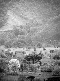
Landscape with forest and single trees near the Pacific coast, Province of Puntarenas, Costa Rica
- C. KLEINN
A pilot study carried out in six countries of Latin America (Kleinn, 1999) showed that data from direct assessments are the exception in that region - or are not accessible. However, the subject of TOF touches on several sectors - most importantly the agricultural sector, but also the urban, forestry and conservation sectors - from which diverse data are available that could possibly be used to produce a large-area estimate.
For example, data on the area of coffee fields are found in agricultural statistics and in statistics of the national coffee institutes. However, the shade tree cover in the coffee fields is heterogeneous, both with respect to density and percentage of area covered and with respect to species composition. In addition, the data are not readily available for large areas, but would have to be taken from a multitude of research studies usually carried out on a limited number of farms. Such small-area studies often provide detailed and high-quality data on species composition, size, volume, biomass, sequestered carbon and spatial arrangement of the tree component, as well as information on its socio-economic relevance. However, it is hard to judge whether the available research studies represent the situation in a larger region and whether it would be methodologically valid to use them for modelling and extrapolation.
Similarly, information on the area of permanent pastures is found in land use statistics, but data on the tree component are scattered. Guevara, Laborde and Sánchez (1998) reported mean numbers of trees per hectare in 45 selected pastures in Los Tuxtlas, Mexico, finding clear differences with respect to slope. Van Leeuwen and Hofstede (1995) measured tree numbers on farms in the Atlantic Zone of Costa Rica; they found it impossible to assess the average number of dispersed trees on pasture through interviews, as the farmers usually underestimated it. This is an interesting finding, as agricultural surveys have been based largely on interviews with farmers.
Existing data alone are unlikely to provide a complete and consistent picture of the TOF resource for large areas, as they come from a variety of data sources and studies, usually conducted in a limited number of smaller areas. However, the data and their usefulness should be analysed as ancillary information for the planning of assessments. This is particularly true for land use statistics and maps, as well as for tree models such as volume functions that are used in forest and agroforestry inventories.
Group of trees, San Andrés Semetabaj, Sololá departament, Guatemala
- G. GÓMEZ
The gross structure of a large-area TOF assessment appears straightforward: a land use map, readily available or, for example, produced from satellite images, identifies the classes or strata where TOF are found. Subsequent efforts then concentrate on estimating the desired TOF attributes in these classes, where different techniques will have to be employed according to the objectives.
Given the particular characteristics of the resource, it is therefore likely that efficient inventory designs will integrate the use of satellite images, aerial photos (or high-resolution satellite images) and field plots. The satellite images are the basis for a land classification, possibly related to the presence of TOF. In addition, they provide complete coverage and make it possible to produce maps of the inventory region using a model-based extrapolation. Aerial photos, where available on an appropriate scale, or high-resolution satellite images help to identify TOF and TOF configurations, support mapping and spatial analysis and assist in fieldwork planning. Detailed field sampling, i.e. more than the verification of satellite image classification, is required if the inventory is to provide more than a mere mapping of tree cover. If species composition, tree dimensions, management practices, ownership, etc. are among the variables of interest, field plots have to be established.
The ownership and the geometry of TOF are major issues in the field phase. The diverse spatial distribution (scattered individual trees, trees in lines, trees in clusters) calls for the development of an adjusted design of sample plots, combining for example fixed-area plots, line samples and distance samples, as known from ecological surveys and forest inventories. The development of such a sampling scheme is currently the subject of a European Union-funded research project technically coordinated by the author. It might be expected that the fieldwork would be easier in a TOF inventory than in a forest inventory, as physical access is simpler and visibility much better. However, TOF occur mainly on cultivated land, and thus in private ownership. It turns out to be extremely time consuming to request permits to enter the private land and do the measurements, particularly where the farms are small and the field measurements are to extend over several farms. This is a major disadvantage in contrast with small-area research studies, which usually involve protracted work in the same area and therefore benefit from a familiarity with the area and the people there. Large-area TOF inventory obviously carries a number of severe organizational difficulties.
The field plots might be distributed according to a land classification (coming from satellite image interpretation or from existing maps), or - in the absence of a suitable pre-stratification - they could be distributed over all lands regardless of tree or forest cover, an approach similar to that of Sylvander (1981). Tree cover in the landscape is then seen as a continuum, and no class of cover is excluded from the outset. This approach points in the direction of comprehensive landscape inventories.
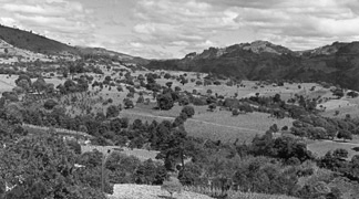
Landscape with dispersed trees, San Andrés Semetabaj, Sololá departament , Guatemala
- G. GÓMEZ
Assessments of TOF have marked differences from traditional forest surveys. The most striking is the higher heterogeneity, which makes it difficult to reach generalized conclusions. The resource itself, its forms of occurrence in different land use classes, the sectors touched and the dynamics of the resource are heterogeneous. The property size and land tenure structure of land where TOF are found are also heterogeneous, and generally very different from those of forest land.
Who, then, should be involved in large-area TOF inventories? A number of government bodies, institutes, projects and non-governmental organizations (NGOs) are immediately indicated if baseline information is to be collected for TOF on all non-forest lands. Integration into large-area forest inventories, i.e. extending forest inventories to non-forest land, would be one solution. However, integration into agricultural censuses, i.e. extending the target variables of the censuses beyond agricultural crops, would be equally sensible, at least for cultivated lands. Perhaps the best solution would be a landscape inventory with the participation of all the relevant sectors (although even this would be likely to have some practical drawbacks - such as higher cost and disagreement over proprietorship of the data, for example). Members of the forestry sector, with their experience in forest inventory and tree mensuration, can play a key part in these activities. Cross-sectoral activities are always a challenge. In TOF inventories, however, their synergy is essential for efficient provision of broadly useful results. In the planning of a TOF inventory it is therefore good practice to contact other possibly interested parties. They might have good information ready in their archives - or they might show interest in participating actively in the new inventory.
TOF inventories depend on and benefit highly from a multitude of ancillary information. Therefore, comprehensive and accessible information systems have a key role - be they digital systems or national or regional centres that archive information on natural resources.
Holmgren, Masakha and Sjöholm (1994) in their study on off-forest trees in Kenya state that there must be forest policy implications when a considerable share of the wood resources of a region is in non-forest. This is certainly true for many regions worldwide, and can be extended to natural resource policies in general. What is still incomplete at the moment is a sound database and an understanding of the particular dynamics of the TOF resource on large areas.
Bibliography
FAO. 1974. Manual of forest inventory with special reference to mixed tropical forests, by J.P. Lanly. Rome.
FAO. 1998. FRA 2000 - terms and definitions. Forest Resources Assessment Programme Working Paper No. 1. Rome.
Finnish Forest Research Institute. 1996. Proceedings of FAO Expert Consultation on Global Forest Resources Assessment 2000 in cooperation with ECE and UNEP with the support of the Government of Finland (Kotka III), Kotka, Finland, 10-14 June 1996, ed. A. Nyyssönen & A. Ahti. Research Papers No. 620. Helsinki, Finland.
Guevara, S., Laborde, J. & Sánchez, G. 1998. Are isolated remnant trees in pastures a fragmented canopy? Selbyana, 19(1): 34-43.
Holmgren, P., Masakha, E.J. & Sjöholm, H. 1994. Not all African land is being degraded: a recent survey of trees on farms in Kenya reveals rapidly increasing forest resources. Ambio, 23(7): 390-395.
Kleinn, C. 1991. Zum Waldbegriff in Forstlichen Großrauminventuren (On forest definitions in large-area forest inventories). Allgemeine Forst und Jagdzeitung, 162: 201-210. (English summary)
Kleinn, C. 1999. Compilation of information on trees outside the forest. Regional Special Study for Latin America. Final report to FAO. Rome.
Lund, G. 1996. Generalities and necessary tangents: considerations for designing agroforestry inventories. In R.K. Kohli & K.S. Arya, eds. Proceedings of the IUFRO-DNAES International Meeting on Resource Inventory Techniques to Support Agroforestry and Environment Activities, Chandigarh, India, 1-3 October 1996, p. 1-12. Chandigarh, India, HKT Publications.
Nair, P.K.R. 1987. Agroforestry systems inventory. Agroforestry Systems, 5: 301-317.
Sinclair, F. 1999. A general classification of agroforestry practice. Agroforestry Systems. (in press)
Sylvander, R.B. 1981. Bosques del país y su distribución por provincias. San José, Costa Rica, Universidad Estatal a Distancia.
Van Leeuwen, A.C.J. & Hofstede, A.M. 1995. Forests, trees and farming in the Atlantic Zone of Costa Rica. An evaluation of the current and future integration of trees and forests in farming systems in the Atlantic Zone of Costa Rica. Technical Series, Technical Report No. 257. Turrialba, Costa Rica, Tropical Agriculture Research and Higher Education Center (CATIE).
