4.5 Comparison of land use with land
The focal point in the evaluation procedure is that at which the various data are brought together and compared, the comparison leading to the suitability classification. These data are:
- The relevant kinds of land use and their requirements and limitations
The comparison of land use with land is here described separately from economic and social analysis, although in practice there may be considerable overlap between them.
4.5.1 Matching of Land Use with Land
At an early stage in the evaluation a provisional selection has been made of those kinds of land use which appear to be relevant in the light of the objectives and the overall physical and socio-economic conditions. Once systematic surveys and studies have accumulated further data the broad indications of the kinds of land use and their requirements will need to be reconciled with more precise information on the land qualities. This process of mutual adaptation and adjustment of the description of land utilization types and the increasingly known land qualities is named matching.
Matching represents the essence of the interpretative step following the resources surveys in the land evaluation procedure, and is based on the functional relationships that exist between the land qualities, the possibilities for land improvement and the requirements of the land use. In its simplest form matching is the confrontation of physical requirements of specific crops (or grasses, trees, etc.) with the land conditions to give a prediction of crop performance. Matching becomes more complex when the production factor is complemented by other performance conditioning characteristics of the land utilization type, including non-physical aspects like labour intensity and capital intensity.
Suppose, for example, that one of the land utilization types is growth of a perennial tree crop such as oil palm. It is essential that soil moisture should remain above wilting point within some part of the rooting zone throughout the year and, in addition, yields are depressed or made irregular by moisture stress. Thus moisture availability is identified as a relevant land quality for this land utilization type. The moisture availability of each land unit on which oil palm cultivation is being considered is determined from their land characteristics, such as rainfall regime, rooting depth and available water capacity. The crop yield under optimum moisture conditions, for specified standards of management, is estimated. The probable depression in yields caused by specified deficiencies in moisture is then assessed. In a qualitative study some rather arbitrary depression in yield, 50 percent for example, may be taken as the criterion separating land Suitable and Not Suitable for this kind of use. In a quantitative study the economic consequences of yield reductions are calculated.
A similar sequence is followed with respect to land qualities which affect inputs. Maize cultivation, for example, is a form of land use involving periods in which the soil surface is bare. Erosion resistance is therefore a relevant land quality. The optimum conditions include level land, requiring no soil conservation works. Using such land characteristics as slope angle, soil permeability, structural stability and rainfall intensity, a parameter representative of erosion resistance is calculated for each relevant land unit. In a qualitative study, the erosion hazard might be divided into classes such as nil, slight, moderate and severe, and at least the last of these classed as Not Suitable. In a quantitative study the costs of construction and maintenance of soil conservation works for each degree of erosion hazard are calculated, and the economic consequences of these costs, for the project and the farm, are assessed.
Among the purposes served by matching are:
- To check the relevance and refine the descriptions of land utilization types
- To permit systematic determination of the management and improvement specifications of each land utilization type on each land mapping unit to which it is suited, and thus of the required inputs (in terms of capital, labour, etc.)
- To estimate the magnitude of the benefits from each land utilization type on each suitable land mapping unit.
The process of matching is further discussed by Beek (1975).
4.5.2 Diagnostic Procedures
Among procedures for estimating inputs and benefits are the following:
- Direct measurement, e.g. from a number of trial sites located or to be established on different types of land within the survey area or nearby
- Simulation methods using mathematical models which establish relationships between benefits (e.g. crop yields) and diagnostic criteria
- Empirical assessment based on assumed relationships between benefits and diagnostic criteria.
The first procedure is to be preferred. It may be possible to obtain information from agricultural trials, unit farms, forestry trials, or pilot development areas for different farming systems already in existence. Where such sites do not exist, steps should be taken to establish them at an early stage. These trial sites are a means of obtaining standards for the second and third procedures. To obtain rapid results crop cuttings may also be taken.
To date, the second procedure has been used relatively little, but it has a potential for the future when more precise data on quantitative environment-land use relationships is obtained.
The third procedure is frequently carried out by construction of a conversion table, in which diagnostic criteria are related to different classes of land suitability. The suitability rating of land depends on the degree to which the land qualities satisfy the land use requirements. In the past, such conversion tables were frequently based on land characteristics; for example, land with a slope angle over 5° could not fall into the highest one or more land classes. The framework recommends that conversion tables should relate suitability classes to limitations based on land qualities; for example, land with an erosion hazard rated as "moderate" might be excluded from the two highest suitability classes for arable use. Supplementary tables, relating diagnostic criteria to combinations of land characteristics, may be constructed.
The first procedure, being based on quantified expressions of the cause-effect relationships between land qualities and the performance of the land utilization type, is one of quantitative matching. The second procedure is also at least potentially quantitative. The third procedure, however, although it may give a quantitative impression through use of numerical values for diagnostic criteria, is essentially one of qualitative matching. For matching to be quantitative, the inputs and benefits must be related to land qualities in numerical terms (usually economic, sometimes production volume).
Systematically arranged information on the relationships between land qualities and productivity (e.g. crop yields, livestock carrying capacity, rates of tree growth) is scarce. A first attempt to improve this situation should include collection of data and the preparation of conversion tables, programmes or formulae for specific uses and especially for individual crops, which indicate defined levels of land qualities for different kinds and amounts of necessary inputs and levels of productivity. Initially, such data will be in physical terms. When required, it can be translated into economic terms on the basis of prevailing costs and prices. Provided that data of this nature can be obtained, it is thus possible to ascribe specific economic values to given levels of land qualities or limitations. Some diagnostic procedures aimed at obtaining estimates of crop yields, under given management practices, specific to soil types are given by Young (1973; 1976, pp. 369-73), and methods for estimating the carrying capacity of grazing lands by Condon (1968). Relationships between land conditions, management practices and crop responses are discussed by Vink (1975, pp.145-168). Examples, including conversion tables, are given in Chapter 5.
4.5.3 Estimation of Benefits and Inputs
One of the main means to assess the desirability of proposed changes in land use is a comparison between the benefits obtained and the inputs or costs required to obtain them.
The benefits may consist of produce, services and other intangible benefits. Produce includes crops, harvested pasture, livestock products, timber and forest extraction products. Intangible benefits include the creation of employment, provision of recreational or tourist facilities, nature conservation (flora and fauna), and aesthetic considerations. The benefit of water conservation, whether by vegetation conservation in catchments or through flooding of land by reservoir construction, might be regarded as either produce or intangible benefits.
Benefits are first assessed in physical terms, e.g. volume of production, estimated numbers of tourists. These are then, so far as practicable, translated into economic terms, on the basis of stated assumptions about prices, etc.
The evaluation of intangible benefits presents special problems. Land used for recreation or protected as a nature reserve does not necessarily produce directly measurable benefits, and in particular it is difficult to translate such benefits into economic terms. In place of a purely commercial approach, a political decision may be needed to set aside areas of land for aesthetic, health, educational and conservational needs. This calls for methods of rating land in terms of land qualities which have a positive or negative effect on its use for recreation or conservation. For example, sustained carrying capacity expressed as man-days per year per unit area could be one measure of land suitability for recreation. Scarcity of land of a given type (2.4.2) and distance from centres of population are frequently relevant. Techniques for evaluating environmental intangibles with special reference to recreation have been reviewed by Comber and Biswas (1972), and the evaluation of aesthetic factors by Leopold (1969).
It is as necessary to assess inputs, or costs, as it is to estimate production. These consist of recurrent and non-recurrent (capital) inputs.
As with benefits, inputs are first described in physical terms, which are subsequently translated into costs. In the case of recurrent inputs, it is first necessary to specify the management techniques, possibly amplifying the details of these already given in descriptions of land utilization types. The goods and services required are then listed. These will frequently include:
- Recurrent material inputs, e.g. seed, fertilizer
A similar estimate is made of inputs needed for capital works, including those needed for major land improvements where intended. Both the recurrent and non-recurrent inputs are then converted into costs.
4.5.4 Assessment of Environmental Impact
Consideration of the environmental impact, or probable consequences of change for the environment, should permeate the matching process and, indeed, the evaluation as a whole. To provide environmental safeguards, it is essential that land suitability shall normally be assessed on the assumption that the kinds of land use proposed will be sustained, that is, capable of being continued over an indefinite period of time. This requires that any adverse changes to the environment shall be neither severe nor progressive.
Environmental effects are not necessarily unfavourable; for example, if irrigation is established in an arid region, the soil organic matter content may be improved. In Europe, some soils have been improved by prolonged application of fertilizers and farm-yard manure; an extreme example is the "plaggenboden" of the Netherlands, the product of transferring livestock wastes to arable land over several centuries.
The most important aspect is to assess the possibilities of environmental degradation, for example soil erosion, soil salinization or pasture degradation. Many changes in land use necessitate to some degree adverse effects on the environment, for example the lowering of soil organic matter levels when forest is cleared for agriculture. What is essential is that environmental degradation shall be neither severe nor progressive. Severe degradation is that in which the land resources are largely and irreversibly destroyed, as for example in severe gully erosion. Progressive degradation refers to the condition in which a resource is being continuously depleted by a land use practice; degeneration of vegetation by systems of pastoralism in which there is no control of livestock numbers is an example.
Where a hazard of severe or progressive degradation is identified, the technical measures necessary to prevent it are determined and their cost calculated. Frequently such land is classified as Not Suitable since sustained use of the type concerned is not possible or the cost of preventing degradation is excessive.
In special circumstances, it may be that some degree of land degradation is accepted as unavoidable. In such cases, the evaluation should state that only short-term use is foreseen, and should give information on the nature and extent of the degradation and on the expected condition of the land when the use ends.
In considering environmental impact, off-site effects, i.e. consequences for the environment outside the area under study, should be considered. Examples are the effects of forest clearance upon river flow regimes, of changes in river water and sediment content caused by reservoir construction upon navigation, fisheries, etc., and the influence of saline drainage water on the quality of irrigation water downstream.
4.6 Economic and social analysis
In qualitative studies, economic and social analysis is only in generalized terms. It may cover, for example, an inventory or analysis of government development objectives, available macro-economic tools and macro-economic data; general information on the present agricultural and other rural economy, including recent trends; an inventory of the technical and institutional infrastructure; available information on population and its present and probable future rates of change; and sociological information, such as land tenure systems, labour potential, educational levels, etc. Constraining problems identified at this stage might include, for example, seasonal labour shortages, adverse tenure conditions, or poor access to markets and services. The market prospects of commodities are assessed and the comparative advantages of the survey area with other regions in relation to these commodities. Much of the information is likely to derive from discussions with farmers, traders and officials, and from publications by government, international and other development agencies.
In quantitative studies, economic analysis plays an important part, although the nature of the analysis varies according to the land utilization type under consideration, and whether the study is at the semi-detailed or detailed level of intensity.
The analysis is often concerned with feasibility studies and project formulation. In land development projects, the economic viability of the development proposals is assessed in two ways: with respect to the users of land and with respect to the country as a whole. In the first of these, analysis is concerned with the economic viability with respect to farmers, firms, or executing government agencies; that is, whether the proposed uses will pay their way from the viewpoint of the users of the land. The second form of analysis is into whether the proposed development will benefit society, i.e. the people of the country as a whole. This is frequently examined by social cost-benefit analysis, in which costs and prices are adjusted in such a way as to reflect the true scarcity value (opportunity cost) of resources to the community. Economic estimation procedures supply an important part of the data required for quantitative suitability classification.
At the semi-detailed level of intensity it will usually be helpful to carry out cost-benefit analysis on a tentative basis, so as to provide guidance on the economic prospects for the kinds of land use considered. This exercise involves making explicit assumptions about the main attributes of the land use (e.g. man-days of labour required, crop yields obtained). By requiring these data it raises the level of analysis and makes the suitability ratings explicit in economic terms.
Where applicable a farm survey confined to the structure of the farm enterprise will be carried out. Linkages between land utilization types and farming systems will need to be established. Stratified sampling based on ecologically and agriculturally homogeneous zones is necessary to make the results usable for land evaluation. This general survey may be supplemented by detailed farm surveys with emphasis on the production processes.
At the detailed level of intensity, economic analysis is based on data relating to the availability of resources and their allocation by producers, input-output relationships, sales patterns, prices and costs, and credit needs and availability. Cost-benefit analysis or other quantitative methods of economic analysis will be employed. At the farm level, optimization techniques may be used to give guidance on realistic farm planning; techniques such as budgeting, programme planning or mathematical programming may be selected, depending on the degree of sophistication that is appropriate.
At all levels of intensity, analysis is not confined to production-oriented objectives nor to return on capital invested. Changes in land use have consequences for other national, or local objectives, such as employment, reduction in numbers of landless people, regional development, or changes in income distribution between sectors of the community. Consideration of these consequences forms a further branch of the analysis. For example, in deciding whether poorly-drained valley-floor land was to be allocated to grazing by livestock or to rice growing, it might be found that the former gave a higher return on investment, but the latter would certainly provide greater employment or take up more settlers; in cases such as this, where there appeared to be a conflict between different objectives, the consequences of each alternative would be assessed and presented as an output from the evaluation.
4.7 Land suitability classification
The results of the matching process are combined with those of assessment of inputs and benefits, environmental impact, and economic and social analysis to produce a classification, showing the suitability of each land mapping unit for each relevant kind of land use.
4.7.1 The Field Check
A field check of the land evaluation is essential in order to ensure that the suitability classes arrived at by the above procedures are in accord with experienced judgement. Field checking is particularly important where a conversion table has been employed in the matching process, since rigid application of such tables can occasionally produce results at variance with common sense. The field checking should normally be carried out by a party including a natural scientist and one or more people experienced in the types of land use concerned, e.g. farmer, agriculturalist, forester, engineer.
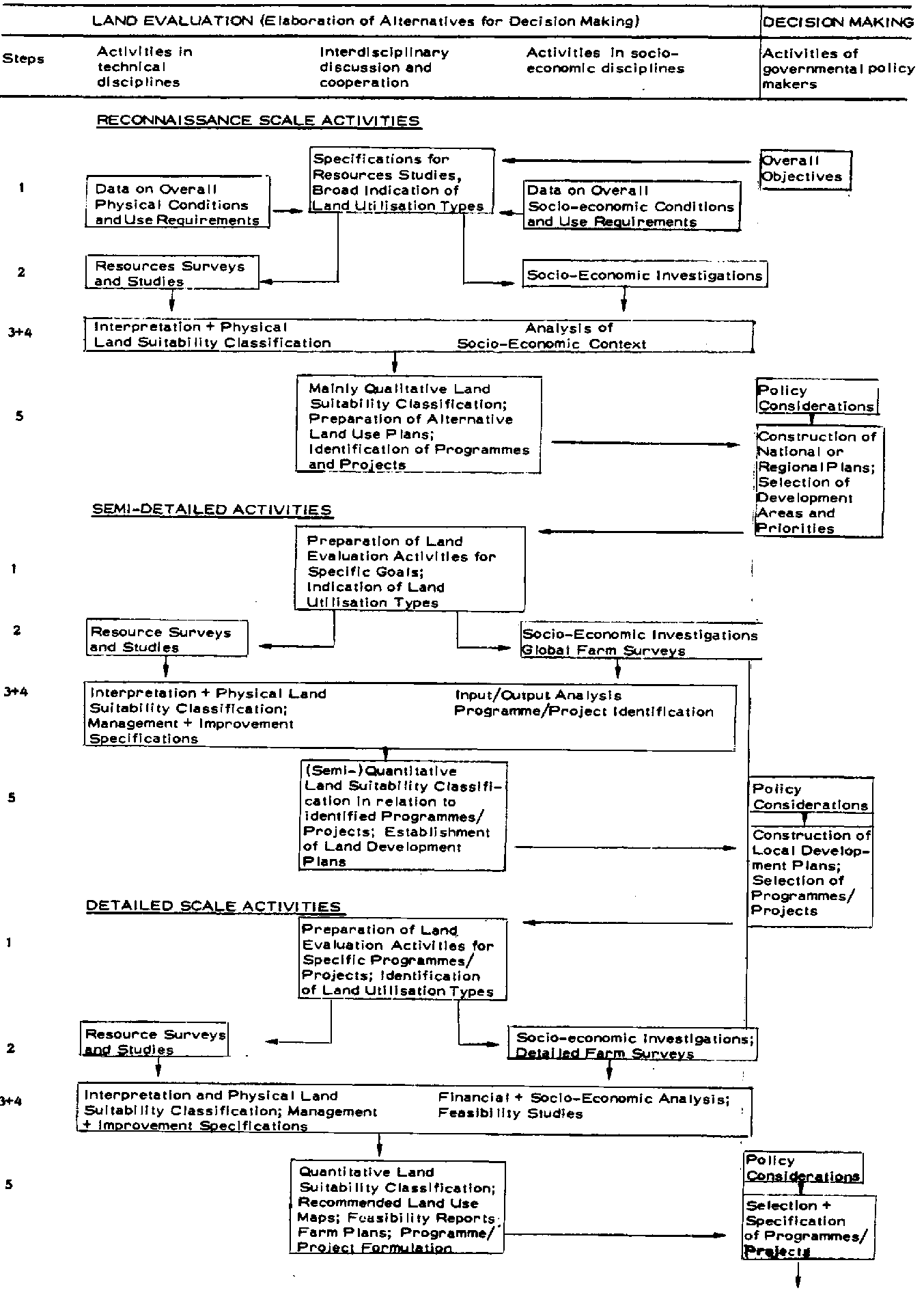
Figures 4 and 5 (from Beek, 1975) show the procedures of land evaluation as a part of land use planning at three levels of intensity according to the two-stage and parallel approaches. These diagrams are necessarily complex, for such is the nature of land use planning, and the precise sequence of interactions will vary with circumstances. Decision making, or the activities of government policy makers, is separated from evaluation activities which supply information for these decisions. The evaluation activities are divided into those in technical disciplines (resource survey and interpretation), those involving economic and social analysis, and interaction between these types. Although shown separately, it is possible that the two-stage procedure will be followed at one or more levels of intensity, usually including that of reconnaissance, and the parallel procedure at others.
The results of the land evaluation are presented in the form of a report and maps, giving the types of information already described. Information on more than one use should always be given.
Land suitability maps, with explanatory legends which may include tables, usually provide the most satisfactory means of conveying the results of evaluation to the user in summary form. A supporting text is always required, to explain the procedures used, to give descriptions of the types of land use, their management and improvement specifications, and their economic and social consequences, as well as to record the data and assumptions on which the evaluation was based.
FIG. 4 TWO - STAGE APPROACH TO LAND EVALUATION
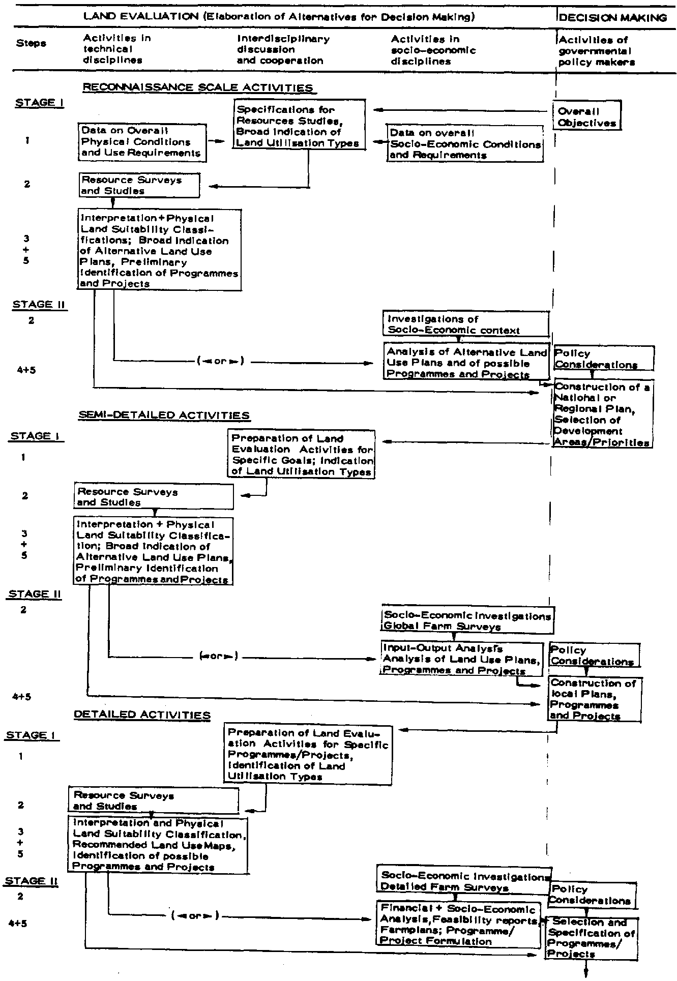
FIG. 5 PARALLEL APPROACH TO LAND EVALUATION
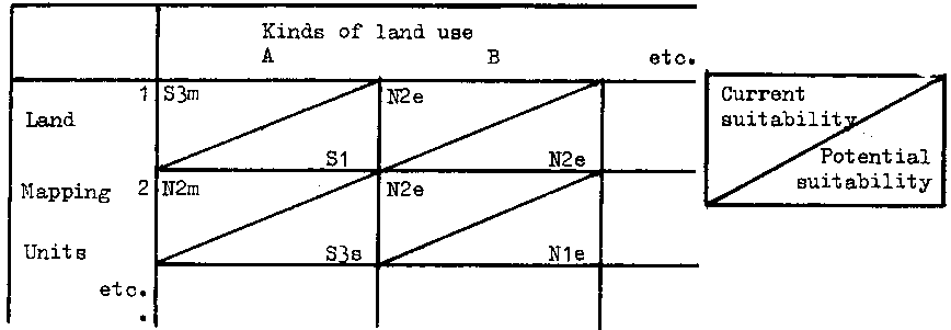
Where suitabilities for several different kinds of land use are to be shown there are two alternative methods. The first is to produce a series of maps showing suitability for each use separately (cf. Fig. 1). In that case, the land suitability map will show land mapping units, each with a shading or colour and a symbol indicating its suitability for that use. The second method is to produce a single map showing boundaries of the land mapping units and indicate their suitability for each kind of land use by means of a table. A convenient form for such a tabular legend is given as Table 3A. Such a legend could show either current or potential suitability and may include suitability subclasses and units in addition to the classes shown.
Table 3A TABULAR LEGEND TO LAND SUITABILITY MAPS 1/
1/Adapted from Mahler, 1970.
Kinds of land use | |||||||
A | B | C | D | E | etc. | ||
Land | 1 | S1 | S1 | S3 | S1 | N2 | |
2 | S2 | S1 | S2 | N1 | N2 | ||
Mapping | 3 | S4 | S2 | S2 | NR | S3 | |
4 | N1 | N1 | S3 | NR | S2 | ||
Units | 5 | N2 | N2 | N2 | S3 | S1 | |
etc. | |||||||
In some cases both current and potential suitability classifications could be given in a single tabular legend, either by showing two tables side by side or by dividing each cell in the manner shown in Table 3B. The nature and extent of the major land improvements should be indicated with the table.
Table 33 TABULAR LEGEND TO LAND SUITABILITY MAPS 1/
1/Adapted from Mahler, 1970.
In cases where land mapping units are not homogeneous, the map or its legend should normally indicate the suitabilities of each type of land within the mapping unit.
Tables can frequently be used to present data in a manner more concise and easy to interpret than text. Tables can be used, for example, to:
- summarize the physical characteristics of land mapping units;
- summarize the characteristics of land utilization types, together with their management and improvement specifications;
- present the suitability classification itself, as in the map legend but in greater detail;
- list the physical, technological, economic and social data employed in each classification;
- present the information used in comparison of the productivity and profitability of each kind of land use.
The text should be as brief as possible and conceived in a supporting role for the maps and tables.
Besides presenting the results of the evaluation itself, it is valuable to record in permanently available form the basic data collected for the purpose of making it. This will often include a soil map with supporting text, and data on geology, geomorphology, climate, hydrology, vegetation, demography, etc. Where the results of the evaluation are presented mainly in economic terms as costs, income and profitability, it is important to record the physical quantities from which income and costs have been derived; this permits reappraisal, leading where necessary to changes in suitability classification, e.g. in the event of substantial changes in relative costs and prices.