![]()
![]()
![]()
By RAPHAEL ZON
The New Fifteen-Year Conservation Plan of the U. S. S. R.
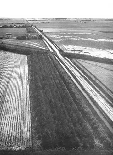
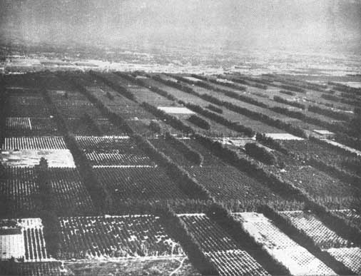
A farm in Nebraska with shelterbelts around the farm buildings and the cultivated fields.
The fifteen-year conservation plan recently announced by the Union of Soviet Socialist Republics makes no claim to new or revolutionary methods. Crop rotation, strip cropping, water impounding, planting of forest strips, reforestation and fixation of shifting sands are well-known methods, successfully tried in many lands. What makes the plan sensational is the scale on which it is being attempted, the limited time (15 years) for bringing it to completion, and the bold purpose of changing the climatic and water conditions of a vast region.
The most significant feature of the plan is the integrated approach to the problem, the realization that all factors which contribute to the highest productive use of land are interrelated and that in order to effect a lasting land improvement the problem cannot be taken up piecemeal but must be attacked as a whole, simultaneously on all possible fronts, with every means at the command of science.
No region can sustain for long a stable productive agriculture if its forests are allowed to deteriorate and become waste land. Neglect the forests and a Pandora's box of disastrous effects is opened. Snow and rainfall permeate the ground under the protection of dense forest cover and enrich the subsoil with moisture; without forest protection they run off as flood waters damaging agricultural land, impeding navigation, causing property damage, and endangering human life. Poor sandy soils when overgrazed or improperly cultivated become blowing sands encroaching upon good agricultural land. As a result of excessive erosion by wind and water, deep gullies scar the land; the ground waters sink lower. Deprived of the moderating influence of the forest, the land is exposed to the extreme fluctuations of the weather. Droughts occur more frequently. The whole environment becomes less hospitable to human life. There are, unfortunately, only too many such degraded regions throughout the world bearing tragic testimony to the folly of man.
A clear and concrete purpose has motivated the U.S.S.R. in undertaking this gigantic project. The Ukraine and Central Russia, with their black soils (chernozem), and the fertile fields of the Volga region and the Northern Caucasus comprise the richest agricultural lands. They are Russia's bread basket; yet, because of their proximity to the Kizel Kum and Kara Kum deserts and the prevailing dry easterly and southeasterly winds that blow from the direction of those deserts, the whole region is exposed to periodic droughts. In 1946 the region suffered from a severe drought, and as recently as 1948 serious crop failures resulted from drought in many parts of the Volga River Basin.
Through its present plan the U.S.S.R. is seeking to insure itself against the uncertainties of weather and to build up in the region a dependable, highly productive, and diversified rural economy. The territory covered by the plan embraces the prairie (steppes) and semiprairie (prairie intermingled with groves of natural forest) region, mostly land lying along the middle and lower stretches of the Volga River in the southeastern part of European U.S.S.R. Asiatic Russia is not included in the plan. While the conservation measures are to be concentrated in the east and southeast, they are chiefly intended to provide a protective barrier as a defense for the agricultural land lying farther west.
The plan calls for five principal activities each supplementing the other and all aiming at the same goal: to reduce the threat of drought and increase agricultural production.
Creation of protection forest zones or barrier
These zones, distinct from shelterbelts around cultivated fields and orchards, are to be established on divides, ridges, slopes of ravines, river banks, and lake shores, and around ponds and reservoirs. The greatest project of this nature is to be the planting by the
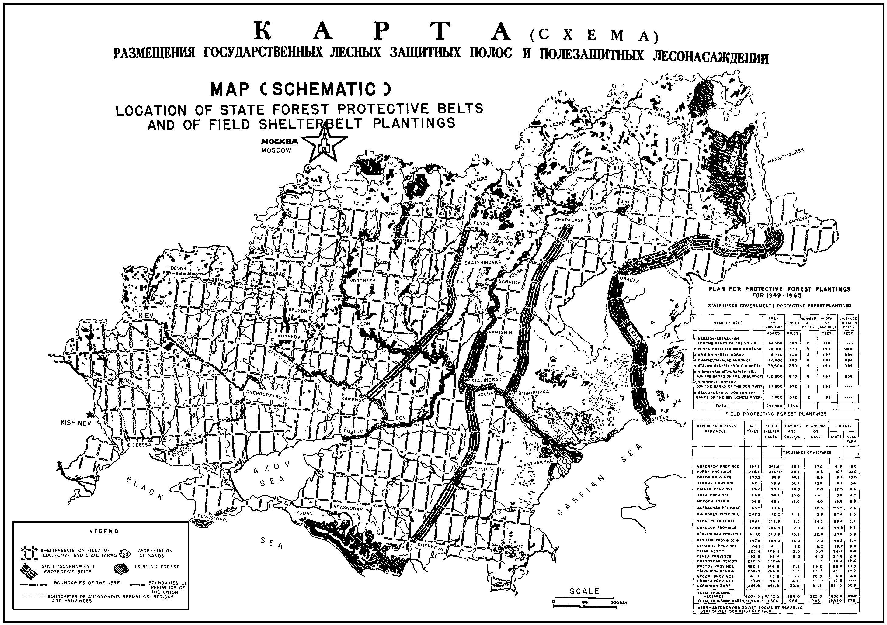
Ministry of Forestry of the Federated Republic of eight long, continuous protection zones oriented at right angles to the prevailing dry southeasterly and easterly winds. Each of these eight protection forest zones is to consist of 1 to 6 parallel narrow belts of trees, each belt from 30 to 60 meters wide, with a distance of about 300 meters between the belts. The total length of all eight protection zones will be over 5,300 kilometers divided as follows:
One forest zone, 100 meters wide and 900 kilometers long, will extend from Saratov to Astrakhan along both banks of the Volga River. Another belt will extend in the direction of Penza to Kamensk on the northern Donetz River. This zone, which is to consist of 3 parallel tree belts, each belt 60 meters wide with 300 meters between the belts, will be 600 kilometers long. A third zone, stretching 170 kilometers in length from Kamishin to Stalingrad along the divide between the Volga River and one of its small tributaries, the Ibovly, is to consist of 3 parallel belts of trees, each belt 60 meters wide, with 300 meters between the belts. A fourth zone 580 kilometers long, will run from Chapayevsk, near Kuibishev, to Vladimirovka-on-the-Volga. It is to be made up of 4 parallel narrow belts each 60 meters wide with 300 meters between the belts. A fifth zone from Stalingrad to Cherkessk (Northern Caucasus) of 570 kilometers length will be in the form of 4 narrow belts each 60 meters wide with the usual distance of 300 meters between the belts. The sixth zone, the widest and the longest, is to run from the southern spurs of the Urals to the Caspian Sea along the banks of the Ural River for 1,080 kilometers. It is to contain 6 parallel belts (3 on the right and 3 on the left bank of the river). Each belt is to be 60 meters wide, but the distance between the belts only 100 to 200 meters. A seventh protection zone is to be extended along the banks of the Don River for 920 kilometers between Voronezh and Rostov-on-Don, and will consist of only one 60-meter-wide belt. The eighth forest zone will be located along the banks of the northern Donetz River for a distance of 500 kilometers from Belgorod to the Don River and will consist of only one belt 30 meters wide. The widest forest zone will be only a little over 2 kilometers wide.
The purpose of these forest zones is to break the force of the hot dry winds from the deserts, to prevent wind and water erosion of the fertile soils of the Volga area and Northern Caucasus and of the black soils of Central Russia, to improve moisture conditions, and generally to temper the climate of the region. The vast undertaking is to be completed by 1965.
Location of state forest protective belts and of field shelterbelt plantings
The corollary of the measures for the planting of forest protection zones is the decree prescribing special methods in the management of the more or less extensive natural forests which occur in the prairie and semiprairie sections of the region. Such stands are found in a number of specially favored areas. They are not to be taken out of utilization, but cutting is to be restricted; no clear cutting is allowed; fellings and thinnings must be made in accordance with the best forest practice in order to improve the remaining stands and increase their density and growth.
Establishment of forest strips or shelterbelts around croplands and orchards on collective and state farms
This is an extension on a greatly increased scale of a policy that has been in effect for some time. Russian agronomists and soil scientists, on the basis of long-term studies and experience, lay great emphasis on the efficacy of strip planting in protecting crops against desiccating winds, in increasing yields, in conserving moisture in the soil, and in reducing loss of soil by wind and water under the climatic conditions of the treeless and semi-treeless regions. Such planting in the next 15 Years is to spread over an area of 5,709,000 hectares of collective and state farms. The total area occupied by the shelterbelts themselves will be only about 5 or at most 10 percent of the area to be served. The collective farms are to be responsible for planting forest strips on the largest portion of the area, namely, 3,600,000 hectares, and for the entire cost of the work. The Ministry of Forestry is responsible for planting on an area of 1,500,000 hectares, and the Ministry of State Farms for planting on the remaining 600,000 hectares.
An interesting and novel feature is the payment of a bonus to the members of the collective farms proportionate to the success of the plantation. If not less than 80 percent of the trees or shrubs planted survive the first year, 10 labor-days per hectare will be added to the regular pay received for such work. If survival after the first year is more than 85 percent, 15 labor-days will be added for each hectare thus planted. If 2- and 3-year-old plantations show not less than 80 percent survival of the trees and shrubs, both the original stock and the later plantings in blanks, 8 labor-days will be added. This is to encourage the growing of sturdy nursery stock as well as careful planting and subsequent care.
Specific instructions are given concerning the species of trees and shrubs to be planted on the 19 different types of soil and under the different climatic conditions. The width of the strips should be determined by the lay of the land and by the purpose the plantation is to serve. For instance, to protect level land chiefly against dry winds, the strips may be only from 10 to 20 meters wide; to protect the fields against erosion by the washing away of the top soil the planting should be done along contour lines in strips from 20 to 60 meters wide; and so on for every set of conditions. The list of trees and shrubs suitable for planting in the treeless and semi-treeless region is varied and long, but emphasis is laid on the desirability of using oak, wherever it is at all possible, as the principal species. To produce an early and lasting effect, the forest strips should contain a balanced combination of fast-growing and slow-growing species. It is laid down as a general rule that the forest strips should contain from 10 to 15 percent fruit-bearing trees and shrubs. While the creation of new shelterbelts over the vast territory is getting under way, the collective and state farms are directed to restore to full effectiveness within the next two years (1949-50), by their own means and labor, all previously existing shelterbelts which were cut down, burned, or otherwise badly damaged during the war.
Fixation and afforestation of shifting sands
To protect the fertile fields of the Volga region, Northern Caucasus, Ukraine, and Central Russia from encroachment by sand drifting in from the dry prairie and semidesert lying close by to the east and southeast, the plan demands that all lands from which the moving sand originates be stabilized as quickly as possible through afforestation and revegetation. Some 322,000 hectares are to be planted within the next six years (1949-55) with drought-resisting forest trees and shrubs adapted to sandy soils, namely, 22,400 hectares in 1949, 43,110 in 1950, and 256,500 in 1951-55. To expedite the process of stabilization, a large area is to be sown immediately with hybrid sorghum and certain grasses so as to convert the sandy areas into grazing and hay land. Provision is made for obtaining enough sorghum seed in 1949 to sow an area of 300 hectares, in 1950 for an area of 20,000 hectares, and in 1951 for 100,000 hectares.
The planting of the contemplated protection forest zones, the creation of forest strips around fields and orchards, and the afforestation of the easily blown sandy soils present a vast reforestation project. An enterprise of such magnitude will require the collection and storage of thousands of tons of tree and shrub seeds, the establishment of many forest nurseries, an enormous supply of tools and mechanical equipment, and great numbers of technical personnel. The plan calls, for instance, for the growing of close to 34,000 million seedlings within the next six years. Some 3,000 million are to become available during 1949, 4,000 million in 1950, and the rest between 1951 and 1955. To supply this number of seedlings, some additional 230 government forest nurseries are to be established in 1949-50; special forest nurseries are also planned for the collective farms to meet their own needs for planting material, one forest nursery for each 5 to 10 collective farms; and all other phases of the work are projected on a similar large scale.
Adoption of a system of crop rotation suited to prairie and semiprairie conditions
While the planting of protection zones and forest strips is destined to create more favorable conditions for agriculture and insure its stability, the general adoption of the most improved agricultural practices, especially of a proper crop rotation, is considered essential for obtaining higher yields, for developing animal industry, livestock breeding, and other branches of diversified farming, thus increasing the whole output of farm products. The plan therefore dwells in great detail on the need for the introduction on all state and collective farms in the treeless and semi-treeless regions of crop rotations with summer fallow and two or more years of perennial legumes and grasses or five to seven years of perennial legumes and grasses followed by about two years of grain and other crops.
Although the directive calls for initiating crop rotation on state farms by 1949 and on collective farms by 1950, the adoption of the crop rotation system by all state and collective farms in the prairie region must be gradual. Leguminous and other fodder seeds are lacking and until a large supply of such seed becomes available, progress will be slow. It is expected, however, that by 1955 the transition will be completed on all state farms and also on the 77,509 collective farms. The crop rotation system when fully applied to the farms of the prairie and semiprairie sections of the European part of the U.S.S.R. will embrace an area of some 120 million hectares.
Hand in hand with the introduction of the crop rotation system, definite soil conservation measures are prescribed, such as plowing, planting and cultivating on contours (across the slope), the use of contour buffer strips of perennial grasses known as strip cropping, and so forth. Stress is also being laid on use of high-grade selected seed for planting, application of proper organic and mineral fertilizers, and measures for eliminating disease, insect pests, weeds, gophers, and field mice. Since the present bottleneck is the shortage of seed, efforts are to be made to increase the supply, especially of leguminous and grass seeds. Large stocks of perennial grass seeds are being ac cumulated, and more than 116 special farms have been organized for the cultivation of selected seed of perennial grasses.
Water Conservation
In order to utilize to the fullest extent all local waste water, the plan calls for the creation of numerous ponds and reservoirs on collective and state farms: in natural depressions, at river sources, in ditches and ravines. The impounded water is to be used for irrigation, fisheries, and hydroelectric power for the needs of agriculture. In all, some 44,230 ponds and reservoirs are to be created on collective and state farms. The surveying, designing, and technical direction are to be provided by the government, but the actual construction is to be done by the farmers themselves and out of their own resources.
A Central Administration for Protective Forest Planting is to be established under the Council of Ministers to coordinate, direct, and control the activities of the three ministries (Forestry, Agriculture, and State Farms) responsible for the actual carrying out of the plan in its entirety. It will also co-ordinate the collection of scientific data and results and interpret the findings. It will be charged with building up the large staff of trained technicians necessary for the work. Finally, it is to publish a monthly technical journal devoted to the discussion of questions of agricultural improvement.
Priority is given to the manufacture of special agricultural machinery and other equipment and implements to facilitate and expedite the realization of the plan. Some 570 stations are to be created in the next two years to perform the mechanical tasks connected with engineering, planting, cultivating, and other phases of the work.
To carry out such a gigantic plan successfully requires a stupendous number of trained technicians. Training is therefore being undertaken on a large scale: in colleges, schools of agriculture and forestry, and universities at the professional level; and also at the farm level. Some 100,000 leaders trained in forest planting, and in grass and crop rotation are being given special two- and three-week courses this winter. Many colleges have increased the enrollment of students specializing in farm-forest management and more than 4,000 specialists are expected to graduate in 1949.
The plan will be watched with considerable interest in North America because the prairie and plains of Canada and the United States present similar conditions and therefore similar problems, although possibly in less aggravated form. The solution also lies along similar lines.
If a map of the United States or of the U.S.S.R. is turned at right angles, the same succession of climate and vegetation is evident. In the United States this succession proceeds from east to west, in the U.S.S.R. from north to south.
On the Atlantic coast of the United States some swampy areas lie close to the shore. Then appear the forests, first a belt of spruces and pines, and then in the Appalachian and Allegheny Mountains region to the west a dense forest of oaks, maples, birches, and similar hardwoods. Farther westward, the hardwood forest gradually thins out, grassland openings appear in it, and the forest gives way to the great treeless prairie and plains region. At first the prairies are covered with tall grass but farther westward as the climate becomes drier the tall grass is replaced by short grass and the prairies by plains. These extend westward to the foothills of the Rockies, Cascades, and Sierras. The slopes and heights of the mountains are covered with dense forests of pines, spruces, and firs. The forest becomes particularly luxuriant on the western slopes of the mountains facing the Pacific Ocean.
In the Arctic region of the U.S.S.R. there is a zone of perpetual frozen swamp, known as tundra. South of it is a wide belt of pines, spruces, and firs - the taiga. This is followed by another forest belt, a forest of oaks, maples, and beech. Farther south the hardwoods gradually peter out and are succeeded by flat grass country - the steppe. Becoming more arid to the south, the steppes extend to the foothills of the Caucasian Mountains. The slopes and heights of these mountains are covered with a dense forest of fir, similar to the Douglas fir, spruces, and pines of the Rockies, Cascades, and Sierras. Beyond the mountains lie the waters of the Azov and Black Seas.
The Russian steppe, like the American prairie, is the bread basket of the country. Yet both the steppes and the prairies are largely flat regions with deficient rainfall ranging from 350 mm. to 525 mm. (14 to 21 in.) a year. They suffer from frequent droughts and are constantly exposed to strong winds. In Russia the prevailing and most damaging winds come from the east, while in the United States they are largely southerly and southwesterly winds. Both regions possess very fertile black soil, known as chernozem, in Russia. It is natural that the people in both regions should seek means to counteract the unfavorable climatic conditions and to improve living conditions. One method used was the planting of trees, protective forest strips, windbreaks, or shelterbelts around farmsteads and cultivated fields.
Russian steppes were settled much earlier than the American prairies. Although tree planting in the steppes dates back to the early nineteenth century (1830), not much progress was made until the end of the century. In 1891 the Russian Government, after a severe drought and famine, appointed a Commission of soil experts headed by Professor V. V. Dokuchayev, originator of the genetic classification of soils now universally accepted, to study the causes of the periodic crop failures in the steppes and to recommend measures for improving conditions. Among other things, the Commission recommended planting protective forest strips or shelterbelts which it believed would (1) protect the farms against the winds: (2) aid in ripening grain; (3) decrease evaporation; (4) effect a more uniform distribution and retention of snow; (5) raise the water table; (6) decrease the range of temperature fluctuations; (7) attract rains; (8) raise the productivity of waste and unused lands; and (9) control soil erosion and shifting sand.
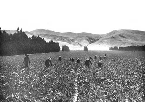
Fields of sugar beets in California protected from unfavorable winds by shelterbelts.
As a result of these recommendations, the first forest experiment station in Russia was established, paradoxically enough, in the treeless region. The experimental plantations were large and numerous and some of them attained international renown. Among these are the Kammenaya Steppe, Derkul, and Mariupol plantations situated in south-central Russia north of the Sea of Azov. These plantations were maintained continuously until the Germans overran the territory. They provided information of great scientific and practical value in regard to the effect of shelterbelts on crops, species most suitable to plant, and methods of planting. The results were so encouraging that the Soviet Government, especially after the famine of 1921, urged the planting of shelterbelts, particularly in the central and lower Volga regions. Between 1928 and 1932 the area of planted shelterbelts rose from 2,000 to about 14,000 hectares (5,000 to 35,000 acres), and the Second Five-Year Plan provided for planting over an area of 350,000 hectares (865,000 acres) around cultivated fields and orchards.
The United States of America has also had considerable experience in this field. Shelterbelt planting began with the settlement of the prairies. Early settlers planted groves of trees around their houses, and some of the plantations were remarkably successful.
In 1873 the U. S. Congress passed the Timber Culture Act. Under this Act any settler who planted 16 hectares (40 acres) of trees on his 65 hectares (160 acres) became the owner of the land. The vastness of the territory, the sparseness of the population, the lack of effective administrative control and of experience prevented in many eases the enforcement of these requirements. Still, as a result of the Timber Culture Act, the prairies are dotted today with shelterbelts around individual farmsteads. American settlers, unlike Russian settlers, did not settle by villages, but each farmer on his own land, separated from his nearest neighbors sometimes by several miles. The country was still under virgin sod and only a small part was brought under the plow. The need for planting protective strips around fields was less urgent than planting for the protection of the houses and barns.
Conditions in the United States, however, have changed radically within recent years. High prices during the First World War stimulated the cultivation of thousands of acres of grassland although large areas were distinctly unfit for farming. The increased area of plowed land forced thousands of herds of cattle and sheep onto other and poorer areas. This led to overgrazing and consequent destruction of the protective grass cover. The stage was thus set for a large-scale national calamity.
As a result of severe droughts that prevailed in the United States in the early 30's, large areas, deprived of their protective vegetative cover and exposed to the drying action of the sun and wind, became a vast breeding ground for destructive dust storms which blanketed almost the entire eastern half of the United States and ruined thousands of farms. As a result, there arose an insistent public demand for measures to remedy the situation. Planting protective forest strips around fields and orchards in the prairie-plains regions was one of the measures proposed.
It was not until 1934 that shelterbelt planting in the United States assumed national importance as a part of the huge program of relief and rehabilitation inaugurated in that year for the relief of the inhabitants of the drought-stricken prairies and plains. In June 1931 the Government made public a proposal to plant shelterbelts on about 512,800 hectares (1,282,000 acres) of farmland within a 160 kilometer (100 mile) wide zone extending through the prairie-plains region from the Canadian border to southern Texas approximately along the 100th meridian. The area to be planted in ten years under this plan compares fairly closely with the 350,000 hectares (865,000 acres) in the 5-year period in the Russian program. Since the planting was undertaken as a relief measure, the entire cost of establishing shelterbelts was at first borne by the Government; later, however, the farmers on whose land the planting was done were to contribute half of the cost in the form of labor, maintenance, and care. With the start of World War II, the shelterbelt project was temporarily discontinued and still remains in a quiescent state. From 1935 to 1942 96,400 hectares (238,200 acres) of field shelterbelts, or 29,900 kilometers (18,600 linear miles) of belts were planted on some 33,185 farms.
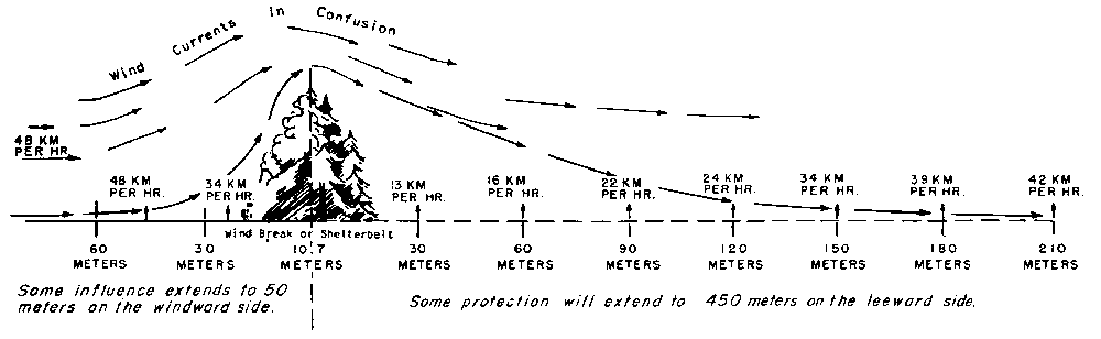
In the United States, farm homes protected on the north by a good windbreak such as is illustrated in this drawing will save 25 percent of the fuel requirements for the winter. When a windbreak protects both on the north and the west, a saving of 34 percent can be expected. Fields protected by shelterbelts made up of 5 to 10 rows of trees help to control wind erosion, contribute substantially to the saving of moisture, and protect crops from damage by high winds. Cattle and horses that are protected by windbreaks require less feed and gain in weight more rapidly. A survey made in the State of Iowa discloses that stock feeders are convinced that a windbreak enables them to save from $5.00 to $10.00 on the cost of feeding every steer.
The Russian scientists, after more than 50 years of experimentation and observation on forest strips planted around fields, have come to very strong and definite conclusions as to the efficiency of such plantings in minimizing the ravages of wind and drought, increasing the yield of crops, preventing erosion, and increasing the moisture in the soil. They found, for instance, that on fields surrounded on four sides by forest belts from 16 to 20 meters (52 to 65 feet) wide, or 10 percent of the enclosed area, the wind velocity decreased 35 to 40 percent and the loss of water by the plants, 30 percent. The snow was 1 ½ to 2 times as heavy within the forest belts as on the open steppe; and surface drainage, when the forest belts were in best condition, was reduced to nothing. These improved conditions are reflected in increased yields. For instance, in the open steppe on fields which are not protected by forest strips but which previously were under legumes and grasses, the yield of spring wheat (with fertilizer) was about 21.2 quintals per hectare (31.5 bushels per acre); a spring wheat field treated in exactly the same manner, but within forest belts yielded about 30.5 quintals per hectare (45.4 bushels per acre). Oats in the open steppe, previously under grass, yielded about 18.6 quintals per hectare (51.9 bushels per acre); similar-fields within a forest belt yielded 21.7 quintals per hectare (60.5 bushels per acre). Winter wheat under similar conditions in the open steppe, yielded 18.2 quintals per hectare (27.1 bushels per acre), within a forest belt, 23.4 quintals per hectare (34.8 bushels per acre).
These findings are confirmed in general terms by numerous observations on shelterbelts planted in the United States of America. When the Russians speak of the value of shelterbelt planting, they are on solid scientific ground and are backed up by long experience. A most concrete and striking demonstration of the effect of shelterbelts was furnished during the severe drought of 1946 - admittedly the worst drought in 50 years. Although the yield of grain at the Kammenaya Steppe Experiment Station where the fields are well protected by forest strips was only about half of the normal yield, it was still 3 to 4 times greater that year than on the adjoining unprotected fields. One state farm which has some 600 hectares of well-developed shelterbelts produces on an average each year more than 25 quintals of winter wheat per hectare.
Planting of forest strips around fields is only a part, though an important part, of the Russian plan. There is also the work under way on the Volga River and its tributaries which is aimed at improving navigation, developing electric power, maintaining the water level of the Caspian Sea, and bringing millions of acres of now dry land into cultivation by irrigation. In a sense, these projects constitute a "Volga River Authority" similar to, but more comprehensive than, the Tennessee Valley Authority or the proposed Columbia River or Missouri River Authorities in the United States.
No specific estimates of the cost of the enterprise are given in the blue print of the plan. The project for the most part is still largely in the planning stage, and there is usually a wide gap between the plan, no matter how thoroughly it is thought out, and its realization. So many of the factors entering into the plan are essential to its harmonious and successful execution that a failure in any one of them may endanger a large segment of the plan itself. A cycle of dry or wet years, for instance, might retard or expedite the plan. A failure of tree-seed crops, an epidemic disease in forest planting stock - things that foresters know only too well do happen - might upset the plan considerably, at least as to the time of its completion.
But no matter whether the Russian conservation plan will be or will not be completed in 15 years, whether it will succeed fully or only in part, whether it will bring all the benefits that are expected from it or not, it is an inspiring thought that man need not always be a destroyer and plunderer of the riches of the earth, but that he can also be a builder and master of his own environment.
Photographs accompanying this article and chart on page 60 were furnished by courtesy of the Soil Conservation Service, U. S. Department of Agriculture.
![]()
![]()
![]()