![]()
![]()
![]()
Forest and Range Aspects in the United States
by V. L. HARPER
Assistant Chief, U. S. Forest Service
In Charge, Branch of Research
WATERSHED management problems in the United States can more readily be understood by first getting a picture of the water supply situation.
The eastern part of the country is relatively humid With annual precipitation ranging from 30 to 80 inches1 and more - fairly well distribute throughout the year. In the western part conditions are quite different. Its interior region gets less than 20 inches2 of precipitation per year, with most of that falling during the winter mouths. This general aridity is modified, however, by high mountains which intercept moisture from prevailing air currents moving eastward from the Pacific Ocean and northward from the Gulf of Mexico. These mountains are the "humid islands" that provide the source of most of the perpetually flowing streams. Precipitation on the mountains varies from about 20 inches3 at the lower-slope elevations to about 80 inches3 at the high altitudes. Much of it falls as snow.
1
760-1,870 mm.
2 500 mm.
3 2,000 mm.
The North Pacific coastal region, west of the Cascade Range, has abundant precipitation. But the South Pacific coastal region, west of the Sierra Nevada, has a Mediterranean climate. In this area intensive agriculture is possible only by irrigation.
Except for localized summer storms, most of the western part of the country has a long, dry season. Throughout the mid-continent area, the summer discharge of streams is about 25 percent of the average flow. In the North Pacific coastal region and throughout the eastern part of the country, the summer discharge of streams is commonly not less than 50 percent of the average flow.
The seventeen western states comprise about 60 percent of the land area of the country, but they have less than 25 percent of the total water supply. The water yield of the West as a whole is less than 4 inches4 per year; that of the East is about 16 inches5. Forest and range land comprises about two-thirds of the total area of the United States. Since forests occupy the regions of heaviest precipitation, it is probable that 70 to 75 percent of the nation's total water yield is from forests and ranges.
4
100 mm.
5 400 mm.
About 12 percent of the nation's total water yield is withdrawn for consumptive uses. Of this water, 40 percent is used for irrigation, 40 percent for industrial purposes, 8 percent for municipal water supply, and 2 percent for rural water supply other than irrigation.
Fifty years ago, the consumptive withdrawal amounted to about 5006 gallons per caput per day. By 1950 it had increased to 1,1007 per day. Demand is increasing at a rate that may reach 2,000 gallons8 per caput per day by 1975. A large part of the water with drawn for industrial and municipal uses does return to the streams, but much of it is loaded with wastes and other impurities. The greater part of the water withdrawn for irrigation is lost through evaporation and transpiration.
6
1,900 liters.
7 4,160 liters.
8 7,570 liters.
The consumptive withdrawals, of course, do not include a much larger volume of water used for generation of hydroelectric power for inland navigation, for fish and wildlife habitat, and for recreational purposes. Conflicting demands for use of water are major economic and political problems in many localities. These will grow sharper as more of the available supply is withdrawn for consumptive uses.
Improvements and projects of various kinds for the use and control of water represent a present investment of about $50 billion9. About one-fourth of this total has been invested by the Federal Government. Plans now in the making contemplate an additional 50 billion of Federal expenditure. If these plans materialize, along with other plans of private interests and of local government a further investment of $75 billion to $100 billion is to be expected in the next fifty years.
9
$50,000 million.
Recognition of the public interest in watershed lands began to take definite form in the United States about sixty years ago. An Act of Congress passed in 1891 directed the President to establish forest reserves out of the forested public domain lands remaining in the western states. While this law made no direct reference to watershed values, the Congressional debates which led up to its passage show that its sponsors included the restraining of floods and the protection of streamflow and water supplies as one of the important purposes to be served. A subsequent law passed in 1897 provided for permanent Federal administration of these lands and specified the "securing of favorable water flows" as one of the purposes they were intended to serve.
Some 138,000,000 acres10 of public land were set aside as forest reserves during the period 1891-1907 under authority of these two laws. During this interim the reserves came to be known as national forests. Their administration was assigned to the Forest Service, a bureau of the Department of Agriculture. A management policy was developed based on the principle of multiple use in which timber production, watershed protection, grazing, wildlife habitat, and recreational values were all given recognition.
10
55,850,000 ha.
This approach to the watershed-management problem, however, had limited, even though important, application because by 1891 the only large areas of forested public domain land were in the western states. The next important development came in 1911 with the passage of the so-called Weeks Act11. This law authorized the Federal Government to purchase forested, cut-over, or denuded lands within the watersheds of navigable streams for the specified purpose of "regulation of the flow of navigable streams or for the production of timber." Largely under this authorization, some 22,000,00012 acres of forest watershed lands have thus far been acquired - mostly in the eastern states. All these lands are managed as part of the national forest system
11
An Act of Congress often takes the name of the member or members who introduce it. This one was introduced and sponsored by Senator Weeks of Massachusetts.
12 8.900,000 ha.
The Weeks Act also initiated a co-operative Federal-State program for protection of private and other non-Federal forest lands from fire. Protection of water resources is one of the stated objectives of the act. This program was greatly strengthened by the Clarke-McNary Act of 1924 which authorized the Federal Government to supply up to one-half of the funds spent by the States for prevention and suppression of fire on such lands. In order to qualify for this financial assistance, a state fire protection system must meet certain minimum standards prescribed by the Secretary of Agriculture. The state contributions to its financing have usually exceeded those made by the Federal Government to a considerable extent. The co-operative system of fire protection now covers about 400,000,000 acres13 of non-Federal forest land, but there are about 60,000,000 acres14 of such land still without organized protection. The unprotected area has, however, been shrinking rapidly in recent years. Coverage may soon be almost complete. The Federally-owned forest lands have been under organized fire protection for a long time.
13
162,000,000 ha.
14 24,300,000 ha.
Forest-insect and tree-disease epidemics destroy timber growth and increase fire hazards. Their control, therefore, is another important aspect of forest protection. In this field, however, progress has lagged chiefly because the damage is not so readily visible until it has become extensive, and because the control job is more difficult. Losses to forest pests have recently exceeded those due to fire by a substantial amount. A desire for more effective control led to the passage of the Forest Pest Control Act of 1947. This lays down a policy of strong Federal leadership in formulating and carrying out control programs. One of the several stated objectives of the new law is to "conserve forest cover on watersheds."
Other features in the development of the forestry program which contribute to conservation of watershed values include the McSweeney-McNary Forest Research Act of 1928 authorizing, among other things, studies of the best methods for "maintaining favorable conditions of waterflow and the prevention of erosion;" and the Cooperative Forest Management Act of 1950 authorizing Federal financial assistance to states for a program of technical assistance to private landowners. A number of other laws that have some bearing on the protection or improvement of forest and range watersheds could be cited.
Although recognition of the public interest in watershed lands began with the forests, it has gradually been extended to other lands. Some 235,000,000 acres15 of unappropriated public domain land remained in the West after the national forest withdrawals had been completed. Most of such land was used for livestock grazing by whomsoever wanted to make use of it. The result was a progressive deterioration of the soil and forage cover, often followed by serious erosion and flash floods. The Taylor Grazing Act of 1934 authorized the Secretary of the Interior to establish grazing districts in order to bring about more orderly use of such land under a permit system. The law recognized the direct tie between water and land by authorizing the Secretary to "continue the study of erosion and flood control and to perform such work as may be necessary to protect and rehabilitate such areas." Unfortunately, the funds that have been made available for this use have not been sufficient to do more than a small amount of rehabilitation work.
15
95,100,000 ha.
The sense of urgency to do something about soil erosion control became manifest in 1933 with the establishment of a Soil Erosion Service in the Department of the Interior. This was a part of the national effort to relieve unemployment. Funds were made available and a considerable amount of work was started. The initial attack was greatly strengthened with the passage of the National Erosion Control Act of 1935 in which Congress declared its policy "to provide permanently for the control and prevention of soil erosion and thereby to preserve natural resources, control floods, prevent impairment of reservoirs, and maintain the navigability of rivers and harbors, protect public health, public lauds, and relieve unemployment." This law transferred responsibility for erosion control work to the Department of Agriculture and authorized the establishment of a Soil Conservation Service to conduct surveys, carry out preventive measures, and furnish technical and financial assistance to suitable districts set up under state lay. All states now have such laws, and the pattern of Soil Conservation Districts is nation-wide and includes about three-fourths of the total land area of the country.
Federal appropriations for the work of the Soil Conservation Service have recently been about $ 60 million per year.
Direct financial aid to farm owners and operators to help them carry out soil-conserving practices has been available since 1936. This was authorized by the Soil Conservation and Domestic Allotment Act, which among other things, sought "diminution of exploitation and wasteful and unscientific use of national soil resources and the protection of rivers and harbors against the results of soil erosion in aid of maintaining the navigability of waters and water courses and in aid of flood control."
While the primary objective of this law was the restoration of farmers purchasing power, the direct payments made to each individual farmer were measured by whatever previous-year improvements he had made in the management of soil and water. These payments are a partial return to him for the costs of terracing sloping fields, for contour cultivation and strip cropping, for establishment of sod waterways to dispose of excess water, for revegetation of severely eroded land, for pasture reseeding and fertilization, for planting trees, and for various other improvements of similar character Appropriations to early out this program have been running at about $ 250 million per year.
The first direct tie-in of these various land-use programs with the program of engineering works for Hood control came in the Flood Control Act of 1936, Declaring that investigations and improvements of rivers and other waterways including watersheds thereof, for flood control purposes are in the interest of the general welfare, Congress directed that the control of floods by engineering works should be expanded to include investigations of watersheds and measures for run-off and waterflow retardation and soil erosion prevention. Responsibility for these watershed investigations was assigned to the Department of Agriculture. Two years later, the Secretary of Agriculture was authorized to install works of improvement for measures of run-off and waterflow retardation and soil erosion prevention on watersheds for which the Department of the Army had been authorized to install flood control engineering works or improvements16.
16
The Department of the Army is the agency with principal responsibility for construction of engineering works for flood control purposes.
Under the authority of these laws, the Department of Agriculture has carried on surveys (completed or in progress) which cover about one-third of the country. The program, as the Department has developed it, calls generally for a speed-up and intensification of land-and-water-conserving measures that have been developed over the years. In addition it includes construction of small water-retarding and silt-detention structures on headwater tributaries, streambank stabilization, and channel-clearance work. An action program, in accordance with survey plans, is in progress on eleven small watersheds located in various parts of the country Survey reports covering quite a number of additional watersheds are being considered by the Congress
While the evidence of public concern about watershed conditions in the United States is ample enough, the practice of the art of watershed management is still in its infancy This is due in large part to scarcity of technical knowledge of the ways in which vegetative cover and soil-mantle conditions affect the behavior of water prior to the time that it enters streams, lakes and aquifers. There are still wide differences of opinion as to the practicability of attaining substantial modifications of run-off and streamflow, especially on large drainage basins, by watershed management. There are people who contend that any kind of vegetative cover is about as good as another for purposes of retarding run-off. This point of view is common in the eastern part of the country. In the West, where water yield is of major concern, there are others who urge that vegetation on the mountains be reduced to a minimum in order to increase run-off impoundment in reservoirs. There are still others who look upon any insistence upon watershed protection as undue interference with their private right to use land entirely for profit-making purposes, such as grazing or timber production. These issues are not easily resolved.
The soundest possible course is to undertake scientific investigations and to be guided by the results in developing policies and programs. Research and experimentation and large-scale tests on pilot watersheds began in 1909 when the Forest Service and the Weather Bureau established cooperatively small experimental watersheds at Wagon Wheel Clap in the Rocky Mountains of Colorado. Since that time, the Forest Service has established two specialized watershed research units the San Dimas Hydrologic Laboratory in the chaparral region of southern California and the Coweeta Hydrologic Laboratory in the deciduous forest area of western North Carolina17. Each of these experimental-watershed areas was first subjected to intensive calibration including topographic and vegetation surveys, measurements of the amount and character of the precipitation volume, and distribution of streamflow and its sediment loads fluctuations in groundwater levels, and various other related factors. After these characteristics were determined, it was then possible to make changes in the forest, inrush, and herbaceous cover and to measure the hydrologic effects of such changes. Similar experimentation on a less intensive scale or on special aspects of the watershed management problem is underway on about a dozen other experimental forests and ranges. The Soil Conservation Service has likewise set up a number of research units to study the hydrologic effects of cover and soil conditions on crop and pasture lands.
17
See Unasylva, Vol.V, No 1, C.R. Hursh, "Research in Forest-Streamflow Relations."
Quantitative evidence concerning the influences of various types and conditions of forest and range cover and their associated soils upon the hydrologic behavior of watersheds has been accumulating. Some of the highlights of that evidence will now be summarized.
The specific measures to be applied to any forest or range watershed depend, of course, upon the principal objectives that are sought. In the eastern part of the country, where precipitation is generally adequate anti well distributed over the year, the main objective is to reduce the severity of floods caused by sudden heavy storms by prolonged rainfall, or by rapid snow melting. Another important objective is to improve the quality of water by reducing its turgidity and sediment loafs. Periodic water shortages caused in part by rainfall deficiencies also arouse interest in the application of watershed management
The first and most obvious effect of forest or range cover on a watershed is the interception of precipitation by foliage and branches before it reaches the ground. The amount of water intercepted varies greatly - depending on whether it falls as rain or snow, whether the forest is coniferous or deciduous and upon the density of the crown canopy. Studies show that forest cover intercepts from 10 to 25 percent of the average annual precipitation, depending on the size and character of the storms and the nature and density of the cover: in certain areas it may he as high ax 35 percent. The highest interception occurs in dense coniferous stands in regions of heavy snowfall, and in dense broadleaf stands in regions of frequent summer rains. The deciduous broadleaf species, of course, intercept little precipitation during their leafless season. Where rapid melting of deep snow pack or heavy summer rainstorms contribute to floods - and total water yield is not of pressing concern - a high ratio of interception by the watershed e over is desirable. Herbaceous and brush cover, such as found on range lands, also intercept precipitation, but not as much as forest cover.
Dense stands of coniferous timber retard snow melt to an appreciable extent. By shading the ground from a large part of the sun's rays, the timber stand maintains a blanket of cool moist air over the snow. It also reduces Final velocity across the Snout Surface. Snow often lingers under heavy timber stands front one to two weeks or even longer than in the open. This, of course, means a slower and prolonged yield of water from the snow pack.
These same factors that retard snow melt also reduce the evaporation of moisture from the forest floor. But in addition to the effects of shading and reduced wind velocity, the litter (leaves, needles, twigs and other organic material) on the forest floor is an effective insulator that retards evaporation of moisture from the soil. Precise measurement of what the reduction of evaporation losses may be is, however, very difficult because plants also transpire water to the atmosphere. An elm tree of average size, standing where soil moisture is plentiful, may transpire about 1,800 gallons18 of water from its leaves in a hot, dry, summer day. Such evidence as we now have, indicates that annual transpiration of upland forest stands in the United States varies from a minimum of about 5 inches19 up to about 15 inches20 - but may go as high as 35 inches21 in heavy stands in the more humid parts of the country.
18
6,800 liters.
19 127 mm.
20 380mm.
21 890 mm.
It is well established that transpiration is an important factor in the disposal of water after it enters the forested soil. If the objective of watershed management is to get rid of excessive precipitation which would otherwise cause flood damage, a high rate of transpiration is not at all objectionable. If, on the other hand, a maximum yield of water from the watershed is desired, reduction of the forest cover will generally increase the volume of water reaching streams. This point will he discussed more fully later.
The various factors so far mentioned (interception, rate of snow melt, evaporation, and transpiration) are, however, not any more important than the influences that vegetative cover has upon the relationships of water and soil. In other words, what happens above ground on the watershed is not more vital than what happens below the surface of the soil mantle. The one affects the other.
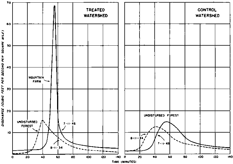
The violent effects of a complete removal of forest and herbaceous cover from mountain land has been demonstrated at the Coweeta Hydrologic Laboratory. Figure 4 shows the hvdrographs of two neighboring small watersheds. Prior to 1939 both of these watersheds were covered with a 40-year old stand of timber. The dotted lines show the close similarity of stream discharge front the two watersheds from a storm that occurred on August 11, 1934. Peak discharge for one watershed was 15 cubic feet per second per square mile22 of the watershed; for the other it was 12 cubic feet per second23.
22
0.0016 m.3 per ha.
23 0.0013 m.3 per ha.
This relationship was typical for similar recordings that had been made over a period of years. Beginning in 1939, one of these experimental watersheds was cleared of timber and converted to a mountain farm. About one-fourth of this farm was plowed and planted to corn; half of it was used for cattle pasture; the remainder was too rough for farming use. For several years the farming was moderately successful but signs of accelerated erosion increased as the organic content and porosity of the top soil diminished. Productivity began to decline. The hydrologic effect of the change from forest to farm use was rather dramatic. A storm occurring on 11 July 1946 produced a peak run-off of 68 cubic feet per second per square mile24 from the farm, but only 16 cubic feet25 from the neighboring watershed still in forest cover. This heavy runoff from the farmed watershed carried a large quantity of sediment and left the cultivated land in a gullied condition, so bad that further effort to grow crops on it for commercial purposes was no longer possible. The unhappy results of improper land use, here demonstrated experimentally, are typical of what has occurred on millions of acres of land throughout the United States.
24
0.0074 m.3 per ha.
25 0.0017 m.3 per ha.
Detailed knowledge of what takes place when vegetative cover is destroyed or removed from the soil has been accumulating. The first effect is a reduction of infiltration capacity - the sustained rate at which water can pass downward through the topmost inch or two of the soil. Where, for one cause or for many, the possibility for quick infiltration is impaired, overland flow results and this causes rapid run-off frequently accompanied by erosive action. A deep layer of forest litter or a mat of herbaceous growth on top of the soil absorbs a large part of the mechanical force of falling raindrops which otherwise strike the bare soil and start the movement of its particles. Such movement causes the finer particles to be washed into the minute openings, thereby blocking the downward movement of the water. The covering of litter or grass on top of the soil feeds the moisture more gently to the underlying soil surface and prevents the clogging of its pores.
Decaying organic matter (because of its sponge-like properties) also promotes the passage of water through the upper layers of a soil. Infiltration is also aided by the activity of soil flora and fauna (partly microscopic) which thrive in it under the forest litter - especially under the litter laid down by the broadleaf trees and by shrubs and herbaceous growth These organisms are continually making passageways through the soil, which serve as openings for the entrance of water. The roots of trees and of grasses and other plants also loosen the soil, and as they die and decay they leave humus-filled conduits for the downward movement of water.
Certain factors inhibit infiltration. One of the worst of these is compaction of the soil surface, caused most frequently by excessive grazing of the land or by use of heavy logging machinery. Another hindrance to infiltration is soil freezing, which occurs in several forms - concrete, honeycomb, granular and stalactite. The concrete type of soil freezing is the only one that is impervious to water Experiments have shown that concrete freezing occurs earlier and goes deeper in open land than in forest-covered land. The older timber stands have less of it than Young stands. It forms more readily under coniferous stands than under broadleaf stands.
Disturbance of the forest floor by fire, grazing or logging is conducive to the formation of concrete frost. In the northeastern, central, and southeastern parts of the country this soil freezing factor is of considerable importance in watershed management because floods are often caused by rapid snow melt or by heavy rain on frozen ground. One of the worst inhibitors of infiltration is a severe fire which consumes all of the organic material on top of the soil as well as the humus that is near the soil surface. Excessive runoff and erosion is often the result of severe burns, especially on land that is burned over repeatedly in the space of a few years. The worst effects usually occur in the more arid sections where vegetative cover is naturally light and the organic content of the top soil is low. If vegetation is slow in getting re-established, the damage done to the watershed by fire is likely to he serious. Watersheds bearing a heavy stand of timber or other plant growth are often not seriously damaged by a single fire, providing the organic matter on the ground is not entirely consumed and providing the plant cover is restored rather promptly.
Soil exposed by the cuts and fills in road building usually has a low infiltration capacity and is often a serious source of run-off and erosion. Roads also act as gutters to intercept subsurface flow and thereby accelerate the concentration of water that has fallen on the land. An experiment carried on at the Coweeta Hydrologic Laboratory showed that the road and skid-trail system commonly used in logging operations caused a considerable increase in peak discharge of a logged-over watershed. The turbidity of the water flowing from this watershed averaged 94 parts of suspended solids per million. The water from a neighboring undisturbed watershed averaged 4 parts per million. The maximum turbidity acceptable for drinking water is 10 parts per million. Much remains to be learned about the roadbuilding methods and location that will cause the least damage to watershed values, and about methods for stabilization of road cuts and fills. The proper disposal of water from road drainage is also an important problem that has received too little attention. Too little of the knowledge we do have is being applied. In the forest-range country, heavily-used livestock driveways are also a critical watershed problem. Trampled to a dust bed during the dry season, they are then easily eroded during the wet season. This sequence is repeated year after year. Meadows and lands bordering the streams are often badly damaged by overgrazing.
After water has entered the soil, some or all of it is held there by the molecular attraction of the soil particles (depending on the dryness of the soil); any additional water moves under the force of gravity to some surface outlet or aquifer. Water retained in the capillary soil pores against the force of gravity is said to be in retention storage. The amount so held depends on the depth and other physical properties of the soil mantle. Clay soils, because of the greater surface of their smaller soil particles, retain more water than sandy soils. A soil rich in organic matter retains more water than one with a low organic-matter content. On the average, a clay loam soil retains about 3 inches of water for every foot26 in depth. A soil mantle of this kind six feet27 deep will be likely to retain about 18 inches28 of water. Water held in retention storage is not available for stream flow. It is available for use of plants - in fact, it is their principal source of water most of the time. Water in retention storage is also subject to depletion by evaporation.
26
250 mm, per m.
27 1.8 m.
28 460 mm.
In areas where flood control is the main watershed problem, a heavy cover of deep-rooted plants not only prevents surface runoff and erosion and induces infiltration and percolation, but also serves as a pump to put water back into the atmosphere by transpiration. This process goes on all the time but speeds up during the season when the plants are in leaf and growing. The soil reservoir is therefore continually being drawn down and put into condition to hold more storm water. When all the retention-storage space is fully occupied, the watershed is said to be at field capacity. After this occurs, there is still storage space for moving water.
This water that moves as underground flow is, of course, the source of all the perpetual-flowing streams and recharging aquifers. In contrast to overland flow, which is intermittent with the recurring storms and is usually silt-laden, the underground flow is more constant and is clear and cool. It is the more valuable part of the water yield. The yield of a watershed in underground flow is partly dependent upon geological and other factors that cannot be modified by watershed management. But it also depends to a substantial extent upon infiltration and percolation, depth of soil mantle, humus content of the soil, and upon the extent to which retention storage has been depleted. All of these last-named factors can be influenced in a significant way by land-use practices.
The most important achievements of forest and range watershed protection and improvement in the United States are in those measures that also serve other purposes protection of forests from fire and pests, reforestation of denuded and poorly stocked land, timber cutting practices that permit prompt natural regeneration of timber stands logging practices that minimize destruction of the residual stand and minimize soil loss through erosion. Varying progress has been made in getting these practices adopted hut we still have a long way to go before any of these are adequate for good watershed management
On range lands there have also been some improvement measures that c contribute to watershed management even though designed principally for other purposes. Considerable effort has been made to obtain more even distribution of grazing animals and thus prevent overgrazing of land adjacent to natural sources of water. This has been clone, to a limited extent, by development of supplementary watering places, by fencing, and by various other measures. Some progress has been made in the timing of grazing on range lands in order to prevent undue trampling of wet ground and to allow adequate seeding of range plants. A start has been made in the reseeding of range land on which natural forage has been badly depleted All of these measures contribute to soil stability and more satisfactory streamflow conditions.
Our main interest at this point, however, is to, describe some of the more specialized efforts that have been made to remedy certain critical watershed conditions that have developed in various parts of the country. Three projects of this kind will now be described:
North-central Utah
The project whose results are most striking is located in north-central Utah about fifteen miles29 north of Salt Lake City. This area was settled about a hundred years ago. Several small towns and about fifty farms were established on alluvial soil near the base of the Wasatch Mountains. The farming land and townsites were located on what was once the bed of Lake Bonneville - a large ancient body of water which receded from ten to twenty thousand years ago to the remnant which is now known as Great Salt Lake. A supply of fresh water for these towns and for irrigation of the farm lands came from several small creeks that drain some 25 square miles30 of steep mountain land lying immediately east of the settlement. These streams maintained their flow throughout the year, with some increase as the snow on the mountains melted during the spring. Heavy summer storms on the mountains are a normal occurrence but these produced only minor increase of the flow.
29
24 km.
30 6,480 ha.
Beginning about 1910, the water regimen began to change. Instead of the gentle increase of streamflow coming from these summer storms, the streams began to carry larger volumes of water heavily laden with muff, rocks and other debris. This trend got worst year after year bringing increasing damage to the towns and farm land. In 1923 great quantities of mud and boulders spewed out of the stream mouths causing heavy damage to homes, farms, highways and irrigation ditches. Six persons were killed. In some places the debris was so deep that it could not be cleared away. Other floods of similar nature followed. By 1930 the accumulated damages were estimated at $1,000,000. Property was being abandoned and people were moving away. At this juncture the Governor of Utah appointed a commission to investigate the flood situation.
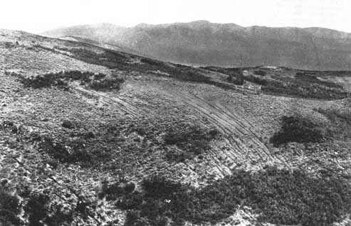
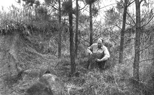
The Commission found no evidence to show that the summer storms were any worse than normal and no evidence that floods of this kind had occurred in the long interim between the recession of Lake Bonneville and recent years. Examination of the watershed high UP On the mountains showoff that the flood waters came and chiefly from areas on which the plant cover and litter had been destroyed by fire and by excessive grazing These flood-source areas amounted to only about 10 percent of the entire watershed but they were enough to dump large volumes of water into the stream channels and thereby produce the floods (Figure 1).
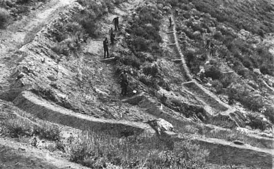
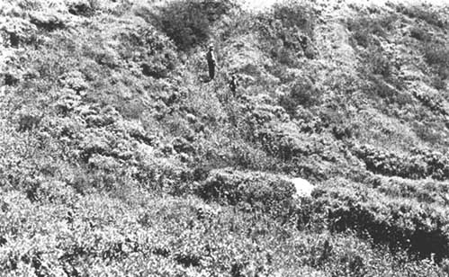
Once the causes of the floods were understood it was easier to find the remedy. Some rather drastic measures were necessary and the people proceeded to take them. The first involved exclusion of all grazing. This was done by purchase of the watershed land, partly by private initiative and partly by public agencies. The publicly-acquired land was made a national forest unit. The next step was an intensification of fire protection to prevent any further destruction of the vegetative cover. The final, and by far the most costly step, was a treatment of the flood-source areas. This involved the construction of contour trenches at intervals of about 25 feet31, each large enough to hold about au inch and a half of run-off (Figure 2). On slopes of less than 50 percent, these were roughed out by bulldozer and then finished by hand work with cross dams every 20 to 40 feet32. On the steeper slopes the work had to be done with horse and plow and then finished by hand As the contour trenches were installed, they were sown with a mixture of perennial grass seeds by broadcasting on the loose soil and raking the seed in. This new vegetation took hold rapidly and soon covered the raw soil exposed by trench construction (Figure 3).
31
7.6 m.
32 6-12 m.
The effectiveness of this rehabilitation job has now been thoroughly tested. The mud-rock floods have been stopped. Storms more intense than any that caused those floods have occurred several times since the work was completed. There has been no destructive surface run-off from the flood-source areas that were fully treated.
While this project involved a total cost of about $300,000 - including the purchase price of the entire watershed - it has stopped damages which within seven years time had amounted to $1,000,000. So long as the protective cover and improved soil conditions are maintained, it will give permanent protection and security to a whole community embracing values of many millions of dollars. The value foregone by exclusion of grazing on the watershed is small in comparison with those values which are now protected.
Northwestern Mississippi
Another project, especially designed to rehabilitate a badly-damaged watershed, includes the Yazoo River basin of northwestern Mississippi. This is in the humid section of the country. Precipitation averages about 52 inches33 per year and is fairly well distributed. The Yazoo River drains about 6 million acres34 of land, lying in the shape of a triangle based on the Tennessee-Mississippi State line and pointing southwestward. The main stem of the river occupies an ancient flood plain of the Mississippi River extending along the western side of the watershed. This is deep alluvial soil. Eastward, in successive belts that extend the full length of the watershed, there are zones of wind-deposited loessal soil overlying sand, brown loam, and heavy clay. Settlement began about 125 years ago amid dense stands of conifer and broadleaf timber. Streams ran clear and carried little sediment to the valley lands.
33
1,320 mm.
34 2-4 million ha.
Clearing went forward rapidly, first on the better-drained lowlands and flat uplands, then on the steeper uplands and poorly-drained lowlands. Cotton and corn were the chief crops under a tenant and sharecrop system. Sawmills began to move in about 1900. By 1930 most of the virgin timber had been cut. Fire repeatedly swept the cut-over areas and left the residual stands in poor condition. Excessive grazing of both the farm and non-farm lands brought further depletion of the vegetative cover, compacted the soil, and impaired its infiltration, percolation, and waterstorage capacity.
The results of unwise land-use in the Yazoo River basin make a sad story. Destructive floods, heavy sedimentation of the lowlands, and destruction of the uplands by gullying are common occurrences.
More than 300 floods occurred in the basin during the period 1929-1941. Several were bad enough to get national attention. Farm family income fell to a level far below the national average.
In 1944 Congress authorized a program of watershed rehabilitation. This included:
(a)
installation and operation of an effective fire control system, which had not existed previously;
(b) reforestation of some 300,000 acres35 of worn-out farm lands;
(c) a program of technical service to assist private forest landowners to improve the management of their timber stands;
(d) control of grazing by means of fencing and other measures;
(e) fertilization of pasture lands and reseeding with improved forage such as Bermuda grass, lespedeza and white clover;
(f) terracing and strip-cropping on sloping land used for crops;
(g) a sound system of crop rotation to replace the, common practice of trying to grow cotton and corn on the same ground year after year;
(h) installation of grassed waterways to dispose of surplus water from fields, pastures and roads;
(i) revegetation of exposed soil on roadbanks and railroad grades.
35
120,000 ha
Supplementing these land-treatment measures, there were also plans for construction of check dams in the gullies and various other small structures to retard runoff and trap sediment.
As originally planned, this program was to be installed in fifteen years. The funds appropriated have not been sufficient to keep on schedule, but despite this handicap, very substantial progress has been attained. The area burned over annually has been reduced to less than 1 percent of the total forest land. Some 16 million trees were planted in 1952 and 35 million will be planted in 1953. Much of this planting has been done in small patches to check the worst erosion sores (Figure 5). The planted patches will soon be seeding the intervening land. Small earth dams and other simple structures have been built at key locations in the tributary channels to reinforce the land-treatment measures while the latter are gradually developing their full effectiveness. Road-bank stabilization, pasture improvement, strip-cropping and crop rotation have also gone forward in a way that is encouraging. Substantial reduction of sediment from the treated areas is clearly in evidence. Improvements in streamflow regimen will follow as the vegetative cover is restored.
Colorado
A quite different kind of project is located high in the Rocky Mountains near Fraser, Colorado. The waters from this area are greatly needed for irrigation of lands in Arizona and California and for the municipal water supply of the metropolitan area of southern California. The main objective of watershed management is to obtain the maximum yield of water that can be had without causing erosion damage. The early experiments at Wagon Wheel Gap showed that water yield could be increased by some 15 percent by removal of the woody vegetation. Soil conditions were such that the herbaceous cover was capable of giving the necessary protection against erosion. The research program near Fraser has been designed to undertake plot experiments and then to test them on a pilot watershed scale. In one series of plots stands of lodgepole pine timber were cut so as to leave five different densities. At the one extreme was the uncut forest, and at the other was a stand from which all trees larger than 10 inches36 diameter at breast height had been removed. Measures meets of snow pack, rate of melting and evaporation- transpiration losses were kept for six years after the cutting operations. The results showed a substantial increase of water available for streamflow. The uncut forest plot yielded 10,3 inches37 of water; the plot cut most heavily, yielded 13.5 inches38. This represented a gain of 30 percent in the amount of water that entered the soil. Now the experiment has been expanded to a 710-acre39 pilot watershed to determine the actual effects of logging on erosion, peak flows, and water yield. There is good possibility that this kind of management can be applied to a fairly large area of high-altitude watershed lands in the West. It would, however, have to be applied with the utmost care and limited to those lands which are naturally stable and not easily damaged.
36
25 cm.
37 26 cm.
38 34 cm.
39 290 ha.
The importance of water management in the economy of the United States is being recognized to an increasing degree. Very large investments in engineering works to control and utilize water have been made, and even larger works are being planned. However, the effects of vegetative cover and soil-mantle conditions on watersheds and thereby on stream regimen have also been recognized in a long series of laws relating to-forest, range, and open lands, and substantial accomplishments in the protection and improvement of watershed lands have already been made through measures adopted primarily for other purposes. In large areas, however, these measures have still not been adequate to give the needed protection and improvement.
Specialized research on watershed management problems, particularly those relating to the effects of land use practices on water yields, has been underway but, so far, on a very modest scale. A considerable body of technical knowledge has been developed and more will be forthcoming as greater public awareness of the need for such knowledge continues to develop. Several outstanding examples, of successful rehabilitation of badly-damaged watersheds are now at hand. These however, are only a scratch on the surface of a very large task that remains to be done.
|
FAO Staff Appointment Thorsten Streyffert, Rector of the Royal School of Forestry,-Stockholm, Sweden, has assumed the appointment of Chief, Economics Branch, Forestry Division FAO. He was recently made Honorary D. So. of Göttingen University, Germany. |
![]()
![]()
![]()