![]()
![]()
![]()
D. A. FRANCIS
Forestry Division, Hunting Technical Services Limited, United Kingdom.
Two of the many problems which face foresters in the tropics are connected with survey aspects of their work, and apply in particular to tropical rain forest areas. These problems are:
1. the location of merchantable timber;
2. its extraction by the most efficient and economic means.
A solution to both problems is the preparation of stock maps showing the distribution of merchantable tree species, and accurate topographic maps which can be used for the planning of extraction routes. By present methods, in most cases entirely on the ground, a considerable amount of costly field work is entailed and this means a slow rate of mapping to cover a given area.
Efforts have been made to speed up the rate of mapping and to produce maps more economically by the use of aerial photography in tropical forest areas. These efforts have met with a varying degree of success compared with the proved value of aerial photography in its application to many forest areas outside the tropics. The reasons for this will be apparent if the preparation of topographic and forest maps from aerial photographs is considered in detail.
In temperate forest areas the stages involved in the preparation of such maps are:
1. aerial photography;2. photo-interpretation and compilation of a preliminary forest-type map;
3. field check of photo-interpretation and inventory of the growing stock, plus provision of ground control for topographic mapping;
4. final photo-interpretation;
5. compilation of maps by the use of photogrammetric instruments.
In tropical forest areas the same sequence is followed. hut the following complications arise in the process:
(a) Aerial photography may only be possible at very limited seasons of the year because of cloud or haze.(b) Photo-interpretation may prove to be of limited value if forest types or individual tree species are not readily identifiable on the photographs.
(c) Field checking may have to be delayed due to climatic or other circumstances, and identifiable photo-patterns visible on the aerial photographs are apparently inexplicable in the field.
Aerial photography of tropical forests
Tropical rain forest areas are notoriously difficult to photograph from the air. This may be due to cloud or haze or a combination of both hazards. Really clear weather is rare over such areas but, given good photographic weather, a large area can be photographed by a survey aircraft in a short time.
Survey aircraft will often have to wait for days, weeks or even months for a brief spell of clear weather in which to photograph a tropical rain forest area.
This naturally adds to the cost of such a survey even though every effort is made to position the aircraft at the optimum period for photography, chosen after examination of the available meteorological records.
The choice of season for photography in tropical rain forest areas is more often a question of photographic weather than vegetative condition of the growing stock. Almost all the tree species are evergreen and it is only when color differences are being photographed that season is considered from the botanical viewpoint. In this respect, aerial photography of tropical rain forest areas differs from the photography of drier tropical forests and of forests in more temperate regions.
The scale of photography used is of great importance to the forester as it determines, to a large extent, the amount of photo-interpretation which is possible.
For individual tree species identification it is necessary for the photographs to be at a relatively large contact scale, i.e., 1:20,000 or larger. Such large-scale photographs have the disadvantage, however, that they give a relatively restricted view of a particular forest area. Photographs at a smaller scale are of much greater use in the initial stages of photo-interpretation work in tropical forests as they give the overall view of a large area. The advent of the latest Swiss and German cameras which have lenses giving a particularly high quality resolution has led to the increasing use of smaller scale aerial photographs by photogrammetrists. Such high quality prints are also of great use to the forester for photo-interpretation. In such cases it is an advantage for the forester to have smaller scale photography for photo-interpretation in the first instance, delineate areas on this photography for further examination. and then recommend further large-scale photography of selected areas.
While it is possible to enlarge contact prints taken with the high resolution lenses, the trouble here is that most stereoscopes and photogrammetric instruments are manufactured for use with about 23 x 23 centimeter aerial photographs. It is also more economic to work with contact prints whenever possible, as otherwise each negative has to be enlarged individually whereas contact prints are rapidly produced on a printing machine.
Modern mirror stereoscopes are fitted with binoculars for the magnified examination of selected areas on contact prints, and in most cases this optical enlargement of the photographic image will suffice for the forester. However, certain stereoscopes will accommodate up to two times enlargements of the contact prints and these are of value in particular cases where the existing aerial photographs are at too small a scale for detailed photo-interpretation.
For photo-interpretation, the writer prefers prints made on glossy unglazed photographic paper. This gives a sharp image and yet has a surface which will take a colored pencil for annotation purposes. Glazed prints have the best definition but this surface means that annotation has to be carried out with a wax pencil and fine lines cannot readily be drawn. Such pencils also have a tendency to melt in hot climates and are, consequently, unpleasant to use in the field.
On the question of the best film and filter combination to use for forest photography in the tropics, the writer's present recommendation is the combination used for "normal" black and white photography. This is Panchromatic film exposed through a minus blue (i.e., yellow) filter. A considerable amount of research has been carried out, and is still being undertaken, to determine the best film and filter combination for individual tree species identification (see following section). Nevertheless, the Panchromatic plus the minus blue filter combination gives the greatest overall tonal rendering over most tropical rain forest areas and is also best suited to the photography of tropical savanna forest areas.
Before leaving the problem of aerial photography in tropical forest areas, the use of supplementary oblique or large-scale vertical aerial photography should be mentioned. For mapping purposes vertical aerial photographs are now the universally accepted medium.
From the forester's aspect, this viewpoint may not be ideal as the side view of the individual tree crowns is often a distinctive characteristic. It is possible to equip an aircraft with either a forward-facing oblique camera, or with two sideways-facing oblique cameras, known as a "tri-camera" arrangement, to provide simultaneous vertical and oblique coverage of a forest area without the expense of flying twice over the same area.
A similar technique may be employed where the scale requirements of the photogrammetrist and forester differ. An area may be photographed from 6,000 meters above mean ground level, using a 6-inch. (about 15-centimeter) focal length lens to give 1:40,000 scale contact prints for the production of topographic maps. At the same time. and through a second camera bay in the survey aircraft, photographs may be taken through a 12-inch (about 30.5 centimeter) focal length lens resulting in 1:20,000 scale contact prints for interpretation purposes. It should be noted that the coverage of the longer focal length lens will not be complete in a lateral direction and the forester therefore carries out his photo-interpretation on the large-scale sample strip and extrapolates, where possible, on to the smaller-scale overall photography.
Photo-interpretation in tropical forests
The normal procedure in forest photo-interpretation is as follows:
1. A preliminary photo-interpretation is carried out by stereoscopic examination of the contact prints, giving an initial breakdown into forest types and, if possible, individual tree species.2. A provisional forest type map is then compiled from the preliminary photo-interpretation to show the distribution of the different forest types or tree species. At this stage these may be indicated by letters or symbols and the map itself be in colored pencil on a transparent base.
3. A field check of this photo-interpretation ii; carried out. This usually incorporates a percentage enumeration on the ground to give volumetric data to apply to the stratification made on the aerial photographs.
4. A final photo-interpretation is then carried out of the photographs which have been ground checked in the field.
5. A final forest type map on a suitably controlled base map is made from the contact prints.
The procedure outlined above falls to the ground when a large block of apparently similar forest type is being surveyed in the tropics. Where there are no recognizable forest types on the aerial photographs or where forest types gradually merge into one another over long distances, then a preliminary breakdown by forest types in other than a very general way, becomes impossible. An analogy with a pack of cards may help the reader to visualize the problem. In the north temperate zones it is usually possible to identify the different forest types on the aerial photographs and to delineate these accurately on the prints. In other words, it is like dealing a pack of cards, face up, and sorting them into the four different suits. Further work on the photographs such as measurements of crown density, crown diameter. stand height, or individual tree heights may be regarded as resorting the different forest types in the same way that each suit in a pack of cards may be put in order.
In tropical rain forests, however, recognizable forest types are few and far between, and the forest type containing the majority of commercially valuable tree species may appear on the aerial photographs as one homogeneous type.
In these circumstances, to return to the previous analogy, it is like viewing a pack of cards reverse side up and endeavoring to select the joker. The joker in this case being the one mature or overmature valuable tree appearing in each 50 or 100 hectares. There is no doubt that, for optimum use of aerial photographs in tropical forestry, it is necessary for the forester to identify individual tree species. However, present experience indicates that this can only be done in a relatively limited number of cases. If the forester is not able to recognize the commercially valuable tree species in a selected area, he may be able to recognize on the aerial photographs tree species which, while not of value in themselves, are indicators of richer or poorer forest types.
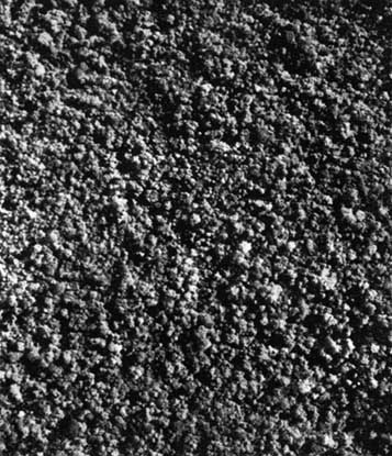
On panchromatic aerial photographs of a forest area in Ghana the only consistently recognizable tree species were the silk cotton (Ceiba pentandra) and the umbrella tree (Musanga smithii.), neither of which are of any commercial value nor are they indicators of a valuable forest type, though Musanga does usually indicate regenerating forest.
Negative information is often useful for the forester in the tropics. Raphia palms indicate swampy areas and appear in situations where there are few commercially valuable trees. The palms show up distinctly on aerial photographs and the limits of such areas may be shown on the forest maps. These areas can be planimetered and their net area deducted from the total area of a map sheet when applying the results of ground enumerations on an area basis.
If there are only a limited number of recognizable vegetation patterns or individual tree crowns on the photographs, a further subdivision of the forest, by stereoscopic examination of the contact prints, into different site classes may be advantageous.
This is essentially a topographic stratification which can be reviewed when the results of field enumeration work are plotted on to the photographs. For example, it may be found that the maximum concentration of economic tree species is found on middle slopes and that the number of such trees found on upper slopes or in wide flat valleys is insufficient to justify exploitation. In these circumstances, the virtual elimination of costly enumeration work in selected sites by concentrating field work in the areas of greatest potential value would he an economy well worth the cost of photographing a forest concession. The accuracy of such photo-interpretation would of course have to be checked from time to time in the field and this would best be carried out by random sampling in reputedly "poor" forest areas.
So far it has been assumed that the forester carrying out the photo-interpretation has been using normal black and white photographs for interpretation purposes.
In view of the importance of locating individual trees of commercial value, research into the use of infrared and color film for species identification has been undertaken. The origin of this research was the writer's observation of the coppery-colored first flush of mahogany (Khaya ivorensis) in Ghana. From the ground the juvenile leaves appear to form a colored zone at the periphery of the crown and it appeared that this flush, photographed from above, would he distinctive. Initial tests using 35-millimeter color film in a miniature camera were promising and resulted in further tests with aerial cameras and aerial color film.
There is now little doubt that a distinctive coloration in any tree species of the upper canopy can be recorded on aerial photographs by the use of color film. The problems are timing, weather and photography.
The first is that of the period for which the distinctive color persists, and is related to the consistency of flowering or flushing. A distinctive color rarely lasts for more than two weeks, and it is even rarer for it to be consistent over an area for the whole of this period. Individuals of a particular tree species may show their color difference at varying periods in tropical rain forests, and the optimum period for photography can only be assessed in the field during the season in which photography is being attempted.
In the tropics, this optimum period may coincide with a period of cloudy weather which may prevent photography.
The photographic problem includes deterioration of the color film, or the images recorded on it, by exposure to high temperatures and high humidities. Haze adds its effect in that the color contrast is lowered by haze over humid forest areas. The haze filter used to improve the color rendering of the film will also depend on the flying height of the survey aircraft, as color transparencies tend to be more blue as the flying height increases. Exposure is far more critical than with panchromatic film this is a characteristic of color film. which is also appreciably slower in emulsion speed than panchromatic. Processing of color film made more difficult in the tropics by the critical temperature requirements of the color developers. These necessitate air-conditioned laboratories and temperature-controlled solutions and because of this, processing is usually carried out in a temperate climate.
Despite all these objections to the use of color film it is, none the less, the most promising prospect for individual tree species identification in tropical forest areas.
Tests undertaken with color film over tropical forest areas in British Honduras and British Guiana have shown distinctive crown colorations. Unfortunately immediate ground checking of the color transparencies was Dot possible and without an early field check such experimental work is of little value. In temperate regions controlled tests have shown that noticeable crown colorations, e.g., copper beech, can be recorded satisfactorily on color film. A further research program to investigate more fully the potentialities of color film in tropical forest areas is being undertaken.
Color aerial photography is at present appreciably more expensive than black and white. Its use can only be justified in the richer tropical forests where individual tree species of large dimensions and high values are found, and where ground conditions make field work difficult, expensive and slow.
Infrared film has been tried under tropical forest conditions but the results to date have shown no significant increase in the accuracy of individual tree species identification. This is surprising in view of the very real value of modified infrared photography to the survey of forest areas in North America.
Controlled experiments over a tropical forest area have not yet come to the writer's attention, but a certain amount of normal infrared and modified infrared photography in the tropics has been examined stereoscopically and in the field. From this material it would appear that pure infrared photography (i.e., infrared film exposed through a deep red filter) has more contrast than modified infrared photography (i.e., infrared film exposed through a minus blue filter) and that the former accentuates tonal differences in individual tree species.
The haze penetration effect of infrared photography, which would appear to be an advantage? is counter balanced by the loss of shadow detail in the photographs and consequent obliteration of forest paths and small clearings. This leads to navigational difficulties when carrying out the field work.
Panchromatic film exposed through a red filter has also been tried in an endeavor to bring out color differences, but the tonal quality of the resulting points showed this technique to be unsuitable.
When the preliminary photo-interpretation is complete the forester has annotated prints, a key to his annotation, and symbols on a preliminary forest type map; the latter having been transferred from individual prints to the map when the prints were annotated. This enables the forester to see the grouping of any distinctive photo patterns. It is not necessary for him to have been in the field as the stratification is done purely on the basis of ocular identification. This ocular identification is later checked in the field.
It is emphasized that at this stage the forester does not know if the photo-patterns he has identified are, in fact, forest types, vegetation associations or tree species, but he has a distinctive pattern which needs to be followed up on the ground.
An aerial photograph mosaic, made by joining together individual contact prints to make an overall picture of a forest area, will prove to be of considerable use to the forester, as on this he can plan his field check of symbols "A-Z" to cover the greatest possible variety of photo-pattern in the least time. His routes can be plotted in advance on this mosaic to make the most economical use of his time in the field, and sites may be selected where a number of photo-patterns can be examined from one point.
Field check of photo-interpretation
The preliminary photo-interpretation, providing a stratification of the forest, should then be checked in the field. Such a check is essentially qualitative, the accuracy of the photo-interpretation being examined to see if the interpreter has been consistent, and to see if identifiable photo-patterns are related to observed conditions on the ground, and whether correlations noted are consistent throughout the area examined
If the greatest benefit is to be obtained from the field check, it must be carried out by the forester who undertook the original photo-interpretation. It should also he carried out as soon as possible after the date of photography or? if this is impossible, at the same season as the photography. The reason for this is that, in tropical forests, individual trees of a particular species may be in a different floristic condition at the same time. In view of this, two individuals which have markedly different tones on a photograph because one is in full leaf and the other just coming into leaf when the photograph was taken, may appear to be identical when examined in the field some months later - and the differences appear inexplicable to the man carrying out the field check.
In tropical forests, the aim of the photo-interpreter should be to carry out a rapid examination of the aerial photographs as soon as possible after the date of photography and to follow this up with an early field check of the photo-patterns. In this connection, it may be of interest to foresters to learn that it is customary for field crews of aerial survey firms to process the films on location, and to make one set of prints in the field to check that they have fully covered an area which has to be surveyed, thereby saving expensive re-flying at a later date. This proof set, while often not as well printed as the later set sent to the client, is quite adequate for field use. It has the great advantage of being only a few days old and, if the forester can obtain such a set, a field check to examine photo-patterns can be carried out at once and any tonal differences which occur within the same forest type or between individual of the same tree species can be seen and recorded.
For quantitative photo-interpretation the larger scale photograph is required, one on which individual tree crowns may be examined in detail. The minimum scale for such work in the tropics should be about 1:20,000 though there are indications that an even larger scale (1:10,000) is preferable as the shape of the individual tree crowns is important. The larger the scale, the closer the spacing of the flight-lines and the more expensive the work but, with ground survey work costing so much, the forester in the tropics may be forgiven if he demands a larger scale of photography than that required outside the tropics.
Individual tree species identification in tropical forests depends to a large extent on the skill of the forester carrying out the photo-interpretation, the quality of the photographs under examination and tonal variation in the trees themselves. It is considered advisable to give details of the quantitative check of the accuracy of the interpretation, e.g., out of 67 type 'A' tree crowns it was found that 65 were Khaya ivorensis and two other tree species, or, all 21 identifications of forest type ' B ' were consistent, the dominant tree being identified as Mitragyna inermis and the forest type designated fresh water swamp forest.
In practice, the writer pricks through the print with a pin and writes brief notes on the reverse side of each print and more detailed in a separate book.
During the field check, notes are made on major vegetation changes, site type, etc., and also on individual tree species.
The field check may be combined with a certain amount of enumeration work, and it should, in any case, make use of existing enumeration data. Strip enumerations, or the location of sample plots, should he plotted on the preliminary forest type maps or on mosaic, and efforts made to relate vegetation trends noted on the enumeration records to patterns observed on the aerial photographs.
For example, counts of emergent tree crowns on aerial photographs may prove to be related to the density of exploitable tree species on the ground. The aim in this case is to relate crown counts on the aerial photographs to field enumeration records, and then to forecast enumeration results from crown counts over areas which have not been surveyed by enumeration parties in the field. In work undertaken by the writer there were indications that this was a promising line of approach where individual tree species could not be identified on aerial photographs. A high emergent crown count, in unexploited forest areas, was related to a high proportion of merchantable trees and vice versa. The crown counts are carried out under a stereoscope with the aid of transparent templates laid at intervals on a grid marked on the photographs.
Enumeration work in tropical rain forests is difficult and expensive, ranging from about U.S.$1.75 to $2.6 per cubic hectare for 100 percent enumeration of mature merchantable tree species.
Naturally 100 percent enumerations are only carried out in selected areas, but in the rich tropical forest areas known to the writer these 100 percent stock surveys were adopted because a lower percentage sample did not produce the information required. In the first instance 1 percent, 2.5 percent or 5 percent surveys were carried out to give an indication of the value of the forest. Practical and economic considerations usually dictate a low percentage survey but it is emphasized that while this percentage sample may suffice for the purposes of a management plan it is generally insufficient for the forester or logging manager concerned with extraction in these areas. Despite the cost, he much prefers the 100 percent stock survey which shows the location of the individual mature trees of each of the commercially valuable tree species. If such a stock map can also show the topography of the area to be exploited then so much the better, but the cost of preparing such a map by ground methods alone ranges between U.S. $2.2 and $2.7 per hectare.1 These prices are likely to increase year by year as labor costs rise, and it is obvious that some means of reducing this overall cost is desirable.
1
Approximate costs Ghana, 1956.
Enumeration work on a more widely spaced grip will reduce the percentage sample and the application of statistical methods to the analysis of enumeration records can result in economies in expensive field work. However, the logging manager concerned with timber extraction would at once complain that he would not be getting the detailed stock and topographic map, prepared from an intensive grip survey. which enables him to plan his extraction roads in the most economic manner.
Enumeration work may be expensive but the cost of road construction on an unsuitable alignment may be far greater than any savings made at the enumeration stage. This emphasizes the importance of a good alignment for the main haulage roads within a forest area and leads to the question of suitable topographic maps for tropical rain forest areas, which is dealt with in a later section.
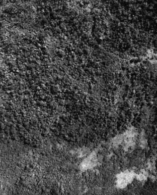
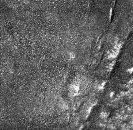
Key
A. Small light colored crowns, grouped
?A. Light colored crowns, possibly 'A' but more scattered
B. Light colored feathery textured crowns
?B. Younger trees of type 'B'
C. Dark close crowns, lower than surrounding forest
D. Open forest on steep slopes -? erosion
E. Medium tone, many light-toned large emergents
F. Riverine forest, scattered large emergents
G. Medium tone, few light-toned emergents
Final photo-interpretation and compilation of a forest type map
Following the field check, the forester returns to his base with the results in the shape of annotated field mosaic or preliminary forest type map. He now carries out a further photo-interpretation of the prints, marking on this occasion the final forest type boundaries which will be transferred to the base map.
The forest type boundaries marked on the contact prints are transferred to the base map by means of a suitable photogrammetric instrument such as a sketch-master or radial line plotter. A suitable scale for a base map is 1:50,000 though for detailed use many foresters prefer the scale of 1:15,000.
The latter scale, or larger, is required if individual trees of mature dimensions are to be shown on the finished maps. In this connection it should be appreciated that trees over a recognized girth limit (27.6 centimeters in the case of mahogany in Ghana) will be more readily identifiable on the aerial photographs by reason of their larger crowns. The crown diameter/stem diameter relationship has not been fully investigated in the tropical forest areas known to the writer, but, there seems to he little doubt that the correlation existing between these factors in temperate tree species applies too to many tropical tree species.
A proved relationship would enable the photo-interpreter using a crown diameter scale to compile a forest stock map showing the mature individuals of identifiable tree species.
Having dealt with the use and limitations of aerial photographs in locating the merchantable timber in tropical forests, its extraction must now be considered.
Compilation of a topographic map en tropical forests
The traditional method of preparing topographic maps in dense tropical forests is that of ground surveys. Traverses and lines of levels are run along existing paths or rivers, and along traces cut through the forest on a grid system. Trace cutting is slow and expensive but until recently there was no alternative to this method.
The new method is to make use of photogrammetric techniques in the preparation of topographic maps. A detailed description of the method used has been published elsewhere,2 and only brief details will be given here.
2
MOTT, P. G. The Contouring of a Tropical Forest Area in Ceylon by the use of Aerial Photographs. Empire Forestry Review, March, 1956 and Photogrammetric Engineering, June, 1955.
Form-lined maps may be prepared from aerial photographs of a tropical forest area through the use of modern photogrammetric machines and a limited amount of ground control. The latter can be eliminated altogether, and satisfactory maps have been produced in this way for a forest area in Ghana, but the provision of a certain amount of ground control is desirable.
The form-lining is carried out by photogrammetrists on the forest canopy through a stereoscopic plotting machine. Variations in canopy height will, of course, affect the accuracy of form-lining, but it has been found in practice that the overall accuracy falls well within acceptable standards.
Such maps can be produced more cheaply and far more quickly than maps prepared by ground methods.
Topographic and forest maps
Modern processes which may be used in the final compilation of topographic and forest maps are such that the maps may be printed separately, or together, or one as an overlay to the other. The use of a transparent nondistorting medium for such maps facilitates the production of cheap dye-line copies of the original maps for field use.
Perhaps the most important function of the finished maps to the forester is the planimetric control which they exercise over all area measurement made on them. The area of each forest type can be planimetered and the degree of sampling in the field adjusted either to give a standard percentage sample over the whole area (e.g., 10 percent by area of each forest type) or to increase the intensity of field sampling in the more valuable forest types.
Dry tropical forests
There are certain features about the use of aerial photographs in these areas which call for comment. First among these is the fact that the stratification of the forest into various forest types and vegetation communities is far easier than in mixed tropical rain forests. Secondly, fewer tree species per hectare mean a greater chance of individual tree species identification from aerial photographs.
Against these advantages must be set the relatively low exploitable potential of the forests themselves. It is possible in these forests to produce accurate forest and topographic maps from aerial photographs supplemented by a limited amount of field work, but only rarely can the yield of timber per hectare provide economic justification for the cost of such a survey.
The forester in these areas will usually have to rely on small-scale aerial photographs taken for topographic mapping purposes, e.g., the small-scale photography of many of the British African territories. Useful and accurate forest maps can be prepared from these photographs and areas of denser forest can be provisionally selected for forest reservation.
Enumeration work is less difficult in these forests and field sampling facilitated by the stratification of the forest which is itself simplified by the clearly defined boundaries to the different forest types.
Ecological relationship are more apparent in such areas as vegetation patterns on aerial photographs often indicate changes in the soils and underlying geological formations.
![]()
![]()
![]()