


Degree in Botany (1972) and doctorate in plant ecology (1977).
Worked with WMO in 1978-79 as a computer programmer in Algeria in the METAG project, using dedicated meteorological communication channels to collect and disseminate crop data from west African and Maghreb countries.
Started work with FAO in 1980 in Tanzania in the first Early Warning Project, as an Agrometeorologist (1980-86): crop monitoring and forecasting.
Joined FAO HQ in 1986 in the Agrometeorology Group, to deal with Crop monitoring.
Since 1994, co-ordinator of the Agromet Group,. Main activities of the Group: crop monitoring, agroclimatic databases, climate change, development of agrometeorological tools.
Special (professional) interests: extreme weather conditions, impact assessments, software development.
The paper stresses the role of weather conditions as a dominant factor of the variability of agricultural production. It examines the scope of agrometeorology, which deals with all agriculture-weather interactions.
"Modern" agrometeorology resorts to a number of data sources (ground-based and satellite) and tools, in particular models.
The author argues that response farming, i.e. the tactical on-farm decision making based on local weather observations, can be modernised by the development of improved decision tables (centrally prepared with local data), and by the dissemination to farmers of customised advice based on the collection of local data. They will then be transmitted to National Agrometeorological Services where they will be analysed. The resulting advice (best management decisions) will be retransmitted to individual farmers though the agricultural extension services, or broadcast. A prototype modern response farming project is described.
2. The Scope of "Modern" Agrometeorology
5. Agrometeorological advice to farmers
The factors, which determine the availability of agricultural products at the local level (farm, village), are environmental conditions and management. The environment includes biophysical factors (climate, soil, pests, land available...), while management encompasses the decisions taken by farmers themselves.
Management decisions are determined by the knowledge of the interactions between the environment, the characteristics of crops and animals, technology, economic factors and the institutional context (including customs, government rules, etc). By definition, economic factors play a relatively minor role for subsistence farmers.
Among the listed factors, weather remains the largest source of variability of farm outputs, directly and indirectly (pests). Depending on the level of development, roughly 20 to 80% of the inter-annual variability of yields stems for the variability of weather. Losses due to pests, diseases and weeds are normally around 15% (Oerke et al., 1994). Post-harvest losses are also of the same order of magnitude.
Extreme agrometeorological events are factors, which often are at the same time rare (low statistical frequency) and characterised by high intensities. They include for instance large pest outbreaks, fire, torrential rains, tropical cyclones etc. They can provoke massive destruction of infrastructure, crops, livestock, fishing gear, etc. and the loss of human life (Gommes, 1999a, 1999c).
Extreme events are not dealt with in this paper for methodological reasons1 and because far more losses are associated with the chronic and inconspicuous effects of climate variability, like droughts, local pest attacks, biodegradation of agricultural materials, hail etc.
In spite of their variability, rainfall, sunshine etc. constitute basic environmental resources. Agrometeorology has the threefold objective of studying the agroclimatic resources, to assess their impact (positive and negative) on agriculture, and to use the knowledge to improve yields.
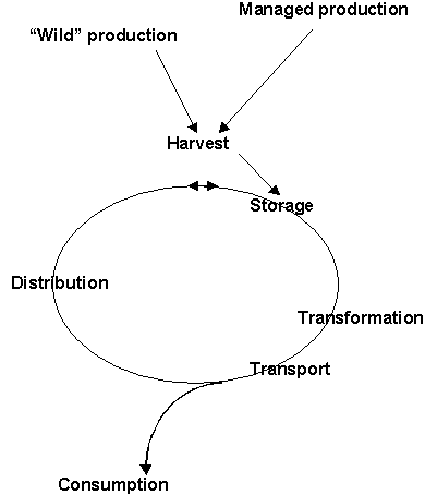
Agrometeorology deals with all the weather-sensitive elements of agriculture production, as illustrated below in figure 1. The spectrum of subjects is thus rather wide. It includes pollination, animal migration, trafficability, transport of pathogens by wind, irrigation, climate manipulation and artificial climates, weather risk assessments, the use of weather forecasts in farming, crop yield and phenology forecasts and particularly advice to farmers... as well as the required data and methods.
Figure 1: Agrometeorology deals with all the weather-sensitive components of the chain leading from production to consumption of all agricultural products, specifically including animals and plants (after Gommes, 1998a).
Agrometeorology now relies on a package of new tools, which define « modern agrometeorology ». They include data acquisition techniques (ground observation, aircraft and satellite), data transmission techniques (including the Internet) and data analysis (models and other software).
A model is a programme (and the science behind it) that simulates (predicts) the behaviour (output) of a plant (e.g. yield) from environmental conditions (inputs, incl. management) and variables describing the plant's ecophysiology (parameters). There is in fact a large variety of models (as well as associated problems) which cannot be described here (refer to Gommes 1999b). Figure 2 below schematically illustrates the operation of a typical model
Figure 2: Schematic representation of a crop simulation model showing the interaction between environmental factors, crop growth and development, and management.
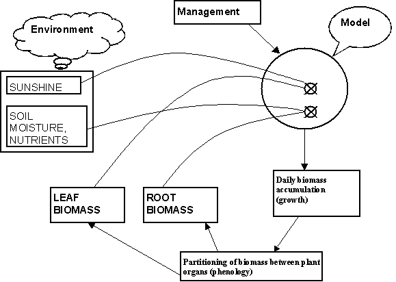
Figure 2
Crop modelling, and most numerical applications in natural sciences became actually possible because of the development of computers, and it is interesting to compare the sophistication of current work with the methods and approaches prevailing 15 to 20 years ago (Weiss, 1981; Gommes 1983 and 1985).
The volume by Albert Weiss is interesting in that it shows that most problems being dealt with today in crop-climate relations were already on the agenda twenty years ago: problems of scale, real-time collection of data and modelling etc. There are, however, three major new issues in the field of crop-climate simulation: geographic information systems (GIS), the spatial interpolation of agroclimatic data, and random weather generators (RWG).
Most popular models now have an "associated" Random Weather Generator, a programme that generates synthetic weather series for a given location3. They are extremely useful for many applications, from risk evaluation to crop forecasting.
Of the associated models and tools, Geographic Information Systems have become ubiquitous. GIS techniques, normally in conjunction with geostatistical software, are used to prepare the spatial input data for the regional applications; they are used after model runs to format and present the output and analyses.
Finally, weather conditions are normally not knows at the exact location where a model is run. Geostatistical tools are now widely used to estimate weather condition at the location where a model is being run, although there is no meteorological station.
There is clear complementary nature of simulation models and satellite data, not only because remote sensing can contribute to estimating surface agrometeorological variables4, but also because it can provide some model inputs, such as phenology (planting dates) and Leaf Area Index, an essential model variable.
In an organisation like FAO, it is difficult to exactly delimit the "mandate" of Agrometeorology. The "Agrometeorology Group", formerly in the Agriculture Department, was aggregated in 1994 with Remote Sensing and Geographic Information Systems -GIS-, the "Rural Energy Group", to create the new Environment and Natural Resources Service under the Sustainable Development Department. This constitutes a logical decision insofar as climate encompasses some of the main renewable natural resources.
Unlike other organisations and institutions (such as WMO and Agrometeorology Departments in various universities), FAO adopts a rather restrictive definition of agrometeorology. Services and products with a marked agroclimatic component6 are provided by other Departments of the Organization. For instance, irrigation scheduling is dealt with by the Land and Water Development Division, Water Resources Development and Management Service. Microclimate manipulation is an essential component of many of the projects of the Plant Production Service, in particular for vegetables. The same could be said about plant protection and production (including forestry), aquaculture development, etc.
The only section of FAO with an explicit mandate to cover agricultural climatology is the Agricultural Meteorology Group. Its main activities include agroclimatic databases, agrometeorology and remote-sensing based crop monitoring and forecasting, international collaboration in the field of climate and weather, including field projects. Recently Climate-change has become a major activity of the Group.
While FAO has a long and good record in agricultural extension at all levels, agrometeorological advisory services to farmers have so far received little attention. It is well recognised that this is an important and potentially very useful field (Gommes, 1992). The Agrometeorology Group has repeatedly tried to develop some activities in this area, but was never able to attract donor attention.
5.1. Weather Forecasts
Weather forecasts play an essential part in many farming operations. For instance, weeding is best done in a rainless period, planting requires regular but not too heavy rain, spraying pesticides cannot be done in windy weather, etc. The main difficulty is often to present the forecasts in such as way that they are understandable to farmers, thus avoiding jargon and ensuring that the uncertainty inherent to all forecasts is duly understood. The general issue of communicating information to the farming community was recently discussed by Weiss et al. (2000).
5.2. Response Farming Applications
"Response farming" is a methodology developed by Stewart (1988), based on the observation that farmers can improve their return by closely monitoring on-farm weather and by using this information in their day to day management decisions.
Figure 3: Flag diagram for Niamey (Niger, based on data from 1953 to 1984), showing the dependence of the total seasonal rain on the date of the beginning of the season (simplified from Gommes, 1992)
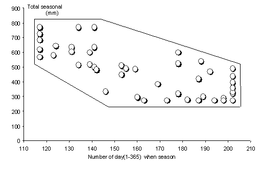
Stewart's original work relied a lot on "flag diagrams", like the one illustrated in figure 3. Such a simple diagram allowed farmers to determine the likely amount of rainfall to be expected based on the starting date of the since, and hence to plan the choice of varieties and soil types accordingly. Operational flag diagrams must be based on recent years to take into account short-lived climate fluctuations.
Response farming emphasises the use of quantitative current data that are then compared with historical information and other local reference data (information on soils etc.). This is a simple variant of the what-if approach. What about planting now if only 25 mm of rainfall was received from the beginning of the season? What about using 50 Kg N-fertiliser if rainfall so far has been scarce and the fertiliser will increase crop water requirement and the risk of a water stress?
The method implies that, using the long-term weather series, decision tools (usually in tabular or flowchart forms) have been prepared in advance. They are based on:
Crop weather models can improve response farming in two different ways. To start with, the decision tables can be improved by using simulation models to better understand the impact of local weather on local crops. Next, models could be run with data of the current year to experiment with the management options and decide on the most appropriate strategies.
In developing countries, the decision-tools must be prepared by National Agrometeorological Services in collaboration with Agricultural Extension Services and subsequently disseminated to farmers. The third operation will be the most difficult in practice (WMO/CTA, 1992).
A similar concept to response farming is flexcropping; it is used in the context of a crop rotation where summer fallow is a common practice, especially in dry areas, like the Canadian prairies. Rotations are often described as 50:50 (1 year crop, 1 year fallow) or 2 in 3 (2 years crop, 1-year fallow). The term flex crop has emerged to describe a less rigid system where a decision to re-crop (or not) is made each year based on available soil moisture and the prospect of getting good moisture during the upcoming growing season (Zentner et al., 1993; Peter Dzikowski and Andy Bootsma, personal communication).
Weisensel et al. (1991) have modelled the relative profitability and riskiness of different crop decision models that might be used in an extensive setting. Of particular interest is the value of information added by the availability of spring soil moisture data and by dynamic optimisation. The simulation has shown that flexcropping based on available soil moisture at seeding time is the most profitable cropping strategy. The authors stress the importance of accurate soil moisture information.
The writer is not aware of flexcropping applications in developing countries, but the concept would be easy to implement.
5.3. Farm management and planning in modern farming
Farmers have been using weather forecasts directly for a number of years to plan their operations, from planting wheat to harvesting hay and spraying fungicides! Models, however, have not really entered the farm in spite of their potential. The main causes seem to be a mixture of lack of confidence and lack of data (Rijks, 1997).
Basically three categories of applications can be identified:
Contrary to most other applications, on-farm real-time operations demand well designed software that can be used by the non-expert, as well as a regular supply of data.
In theory, some input could be taken automatically from recording weather stations, but the reporter did not come across many specific examples. What comes closest is probably a publication by Hess (1996). The author underlines the sensitivity of an irrigation simulation package to errors in the on-farm weather readings.
Systems have been described where some of the non-weather inputs come from direct measurement (Thomson and Ross, 1996). Model (PNUTGRO) parameters were adjusted as the system was used based on soil water sensor responses to drying. An expert system determined which sensor readings were valid before they could be used to adjust parameters.
Irrigation systems have a lot to gain from using weather forecasts rather than climatological averages for future water demand. Fouss and Willis (1994) show how daily weather forecasts, including real-time rainfall likelihood data from the daily National Weather Service forecasts can assist in optimising the operational control of soil water and scheduling agrochemical applications. The authors indicate that the computer models will be incorporated into decision support models (Expert Systems) which can be used by farmers and farm managers to operate water-fertiliser-pest management systems.
Cabelguenne et al. (1997) use forecast weather to schedule irrigation in combination with a variant of EPIC. The approach is apparently so efficient that discrepancies between actual and weather forecasts led to a difference in tactical irrigation management.
5.4. Implementation of "Modern" Response Farming in Developing Countries8
The tools described above are not only for the developed farmer. They can contribute towards greater food security through less weather-dependent practices. This can be achieved by more efficient agrometeorological advisory services to farmers to stabilise their yields through better management of agroclimatic resources as well as other inputs (fertiliser, pesticides).
The section below is based on a project document, which was recently prepared for the Mekong delta, the main rice-growing areas of Vietnam9.
Agrometeorological advisory services to farmers can be improved only through better co-ordination between the Agricultural Extension Services (AExS) , the National Agrometeorological Services (NAmS) and the Media. In particular, "response farming" has to be "evolved" (experimented) first under local pilot conditions with improved data collected by NAmS and AExS before it can be applied on a wider scale.
The general approach includes several steps: The preparation of the methodology (development of the decision tools) by NAmS and AExS, the experimentation of the management scheme by several pilot areas (farmers, communes), the critical evaluation of the impact of the advise on farm output in terms of quantities and regularity, and eventually the adoption of the method in a larger area. Public information and the involvement of the media constitute an essential component of the methodology at all stages.
The central issue, as indicated above, is the preparation of the decision tables. It is proposed to adopt the three steps below as the main objectives of a "modern" response farming project.
A. Identification of Main Focus for Agrometeorological Advisory Services and Response Farming
B. Tested Decision Tools
C. Agrometeorological Advisory Services Are Expanded Beyond the Pilot Area
AExS and NAmS jointly critically evaluate the outcome of the pilot phase, and make final decision on the methodology and the feasibility and relevance of expanding the approach to a wider area (several provinces).
D. A Comprehensive Plan To Improve Agrometeorological Advisory Services Nation-Wide
Modern agrometeorology can resort to a number of sources of data and techniques of analysis, such crop models, Geographic Information Systems, Random Weather Generators and spatial interpolation techniques.
In addition, the transmission of crop and weather data from the rural areas to the national agrometeorological services is now easier than in the past.
National meteorological services should focus on two aspects to reduce the wasteful use of climate resources:
