![]()
![]()
![]()
The need to value environment
Until recently environmental issue has been largely ignored in conventional economic analysis and decision-making, whose main objective has generally focused on profit maximization. Chapter 1 explained that the environmental system is a key development factor and that it has a finite capacity to provide for human needs; in economic terms, it is a scarce resource. Though scarcity of environmental resources and services may be very high in certain regions of the world, the economic value generally placed on them is often underestimated and close to zero. In many cases this has led to an unsustainable path of economic growth.
It is also stressed that evidence does not provide a clear response to the question of whether economic growth and environment protection and conservation are conflicting or complementary goals. Rather it shows that trade-offs and complementarities depend on various other factors such as: the scale and the structure of the economic and the social systems, technology, efficiency with which natural resources are used.
Economic, environmental and social dimensions of sustainable development
In addition it is pointed out that economic and environmental issues are two important but not absolute conditions for ensuring a sustainable development. A third dimension, the social dimension, has also to be accounted for because humans are integral parts of ecosystems. Humans and ecosphere are partners in ensuring a good quality of life. It follows that protecting natural resources, their composition, structure, and functions, is protecting humans and life on earth.
Finally, it is argued that as not all of these objectives can be maximized, it is important that trade-offs among them are analysed and made clear and that any decision-making focusing on one or two of these dimensions may not lead to sustainable development.
In the last decades substantial improvements have been achieved in the general knowledge of environment-economy interactions from both the scientific/technical and economic viewpoint, including how future generations can be accounted for in decision-making. Considerable work has also been undertaken to analyse the interactions between some social aspects and natural resources depletion[40], though more investigation is still required in this area. Further investigation is also needed to understand and measure the interactions occurring simultaneously between the three dimensions.
As a result of this work, decision-making in development planning activity has also undergone substantial changes in terms of both the general approach to decision-making and the analytical techniques and tools.
Decentralized decision-making for the environment
Decentralized decision-making is often considered to be more effective in addressing environmental problems. Chapter 2 concludes that though environmental problems are generally location-specific, there is no valid reason to assume that all related decisions should be taken at the local level.
Even when geographical decentralization is advisable, this does not mean that decision-making at the various geographical levels are independent. On the contrary, decentralization must be thought of as a network of a multitude of decision-making centres linked by the same vision for the future, which is usually established on the basis of strategies and plans prepared at the national or international levels. As Ostrom[41] points out “many biological processes occur at small, medium, and large scale. Therefore, governance arrangements that can cope with this level of complexity also need to be organized as multiple scales and linked effectively together. An example is provided by irrigation systems. It is not uncommon to find large irrigation systems at the local government or higher level with multi-level sub-systems, each with its own rules. In this case, smaller level organizations are nested in ever larger governance systems”.
Moreover, geographical decentralization does not necessarily require that institutional decentralization goes as far as devolution. Various combinations of forms of decentralization can be found to cope with environmental and natural resources management problems, depending upon the specific conditions. A number of criteria have been suggested to help find the most effective forms of decentralization.
It is argued that centralization and decentralization should not be considered antagonist conditions. In most countries an appropriate balance of centralization and decentralization is essential to the effective and efficient management of environmental problems. Not all functions can or should be financed and managed in a decentralized fashion. And even when national governments decentralize responsibilities, they often continue to play an important role in policy and supervisory functions. They must create or maintain the enabling conditions that allow local units of administration or nongovernmental organizations to take on more responsibilities. Central ministries often have crucial roles in promoting and sustaining decentralization by developing appropriate and effective national policies and regulations for decentralization and by strengthening local institutional capacity to assume responsibility for new functions.
Role of government
The role of the central and local government in decentralized decision-making is analysed in detail in Chapter 3. It is argued that proper and effective environmentally sustainable decision-making requires profound institutional and cultural change in the society. It entails that environmental concepts be incorporated in the values, attitudes, and behaviours at both society (at any geographical or administrative unit) and individual levels. The government at any level can play an important role in this process through direct investments in the environmental sector, the creation of an incentive system able to guide private entrepreneurs towards a more sustainable use of natural resources, the design of more appropriate institutions or the re-organization of the existing ones.
Also important to achieve the above changes is the adoption of a decision-making approach able to better account for the complexities of the environmental problems and of the sustainability concept. That is, a decision-making framework able to place due importance on:
capacity-building;
information and communication;
co-operation;
negotiation; and
consultation and partnership,
which, in turn will:
improve environmental knowledge and awareness;
optimize information collection; and
gain support, consensus, and commitment of individuals in the identification, preparation, implementation, monitoring and evaluation of environmental programmes.
In Chapter 4, the stages of decision-making that deserve particular attention from the environmental point of view are reviewed. It is stressed that two conditions are of primary importance for a proper consideration of environmental problems in decision-making, namely well defined spatial units and information generation. It is also highlighted that participation plays an important role in the collection of the required information, as well as in the identification of objectives, planning of actions and monitoring.
Tools for environmental decision-making
The tools available to perform effective decision-making integrating environmental considerations are examined. It is argued that if the decision-making process may be a resource demanding (both time and human resources) and expensive activity, a number of tools exist, that can reduce the overall costs and which have already been widely used in decentralized planning.
The integration of environmental concern in decision-making at the decentralized level is crucial and urgent if the negative trend in the stock of natural resources is to be reversed.
Economy-wide policies are beyond the control of district level administrations, thus they will not be addressed in this document. However, exchange rate, trade and fiscal policies have substantial influence on relative prices and incentives in the use of natural resources at the decentralized level. It is, therefore, important that decentralized level actions and policies aimed at achieving environmental and sustainability objectives be compatible and fit within the framework of the economy-wide policies. The tight relationships between national and local policies also entail that environmental objectives at the decentralized level cannot be achieved if environmental considerations are not incorporated in economy-wide policy decisions.
In this section a number of policy tools available at the district level are discussed. These encompass command and control, economic and institutional instruments.
COMMAND AND CONTROL INSTRUMENTS
Sometimes also named regulatory measures, command and control instruments are generally aimed at reducing or minimizing the impact of human activities on the environment through restrictive laws, or at prohibiting certain activities. Therefore, they generally lead to some erosion of individual freedoms in the society. However, as long as environmental degradation continues and options decrease, some form of prohibition and restriction will be necessary to control the access and use of declining renewable and non-renewable natural resources. Among the most widely used regulatory instruments to protect the environment are:
standards (e.g. gas emissions from cars cannot exceed a threshold value);
quotas (e.g. kilograms of mushrooms that can be collected per capita in one period), permits (e.g. release of wastewater into rivers);
licenses (e.g. hunting of whales or game animals);
land use controls such as zoning; and
building controls in areas of particular environmental or cultural interest.
All these instruments can be easily used at the district level because they are often related to location-specific environmental problems and are not required to be uniform throughout the country. These instruments are categorical in the sense that they leave individuals and enterprises with no choice but to comply with the existing regulations. Often they are associated with penalties and fines.
In addition to the above instruments, property rights and land tenure systems are also regulatory measures that may help improve the management of natural resources. As Calabresi and Melamed (1992) pointed out, property rights can take the form of property rules, liability rules, or inalienable entitlements. Carlson et al. (1993) also add that in order for markets to lead to an efficient allocation of natural resources, property rights to the resources must have some degree of four characteristics:
ownership,
exclusivity,
transferability, and
enforcement.
Ownership provides the owner with the right to use the resource. Exclusivity ensures that all costs and benefits will accrue only to the users. Transferability implies that property rights are tradable. Finally, enforcement is the condition for the property rights system to be effective. It must also be pointed out that property rights effectiveness will be higher if they are coupled with well developed markets.
However, in real life there are no pure private rights. Exclusivity, which is the main distinction between a private property resource and an open access resource, is seldom respected because many activities produce externalities. So, for example, the odour from a pig farm may make the neighbour’s property value decline, thus producing a negative externality or a cost accruing to someone else. In this case the exclusivity condition fails. Because of the difficulty to comply with all the above conditions, property rights systems are often complemented by other policy measures, such as standards, charges, taxes and so forth.
On the other hand, shifting from a traditional tenure system to a private one may generate other externalities detrimental to the environment (e.g. short leasehold terms may lead to the intensification of crops growing on steep slopes). It is therefore important that property rights and land tenure measures be: (i) accompanied by other policies aimed at avoiding the possible environmental impacts, (ii) introduced gradually in order to leave time for creating awareness among land users and providing information about changes occurring in tenure arrangements.
Some simple and basic rules for setting up an effective regulation framework at the district level are the following:
Ensure that skilled staff and financial support for the programme administration exist;
Train the personnel that will be responsible for the collection of fines and penalties;
Adopt a realistic set of standards which can be easily monitored and enforced;
Define precisely the criteria against which the outcomes of regulations will be measured to avoid situations of unreasonably stringent and cost-ineffective regulations;
State clearly how the programme will be implemented.
ECONOMIC INCENTIVES
Economic incentives or market-based instruments include:
charges;
taxes;
subsidies;
deposit refunds; and
tradable permits.
Charges and taxes are aimed at reducing the use of products or activities that may have adverse effects on the environment and are based on the Polluter Pays Principle. Charges are usually related to the provision of a service (e.g. water treatment and conveyance) whereas taxes are not (e.g. taxes on leaded petrol).
Subsidies, on the contrary, are intended to promote the consumption of environmental-friendly products or activities (e.g. subsidies on land conservation practices).
Deposit refunds encourage potential polluters to dispose of harmful goods safely by placing a surcharge on the price of the good, which is reimbursed when it is safely disposed of (e.g. plastic, cans, and glass disposal schemes).
Tradable permits (OECD, 1995) entail trading the right to pollute among potential polluters. In other words, potential polluters are allowed to buy and sell emission quotas within the limits of emission standards. With this mechanism, polluters who introduce less polluting processes economize on their quotas and are free to sell them to other polluters who cannot manage with their quotas[42].
The choice of the most appropriate economic instrument depends on the characteristics of the environmental problem to be solved. For example, deposit refund systems are better suited for products which can be reused, whereas emission charges should be preferred for stationary pollution sources and in situations where marginal abatement costs vary across polluters.
However, some general criteria in the choice of the most appropriate policy measure can be identified. Following the suggestions of OECD (1991), these are:
environmental effectiveness, i.e. the capacity to achieve the environmental objective (e.g. reduce the local concentration of a given pollutant to pre-set standards);
economic effectiveness, i.e. least cost (both direct costs and indirect costs in terms of opportunities foregone) policy measures should be used to achieve the same environmental objectives;
equity, distributive impacts of policies should also be accounted for. For example, equal discharge standards may imply widely unequal marginal and/or total abatement costs between polluters and pollutees;
administrative feasibility and costs, these relate to the costs of monitoring and enforcement of the policies; and
acceptability, the higher the involvement of target groups in the identification of the most appropriate policy measure, the higher the probability of success of the instrument chosen. It implies adequate information, consultation, and phased implementation in order to leave the potential polluters the necessary time to adapt to the new situation.
Though in theory all the above instruments could be applied at the district level, there is little evidence of these being actually used in the developing countries. This is mainly due to the following factors:
decentralization is rarely accompanied by real empowerment of lower level administrations;
lack of skills in their use and in the assessment of their impacts; and
absence of well developed market mechanisms and institutions.
ADVANTAGES AND LIMITATIONS OF COMMAND AND CONTROL AND ECONOMIC MEASURES
The major advantage of command and control measures is the higher familiarity of decision-makers with these instruments when compared to other measures such as economic instruments.
The major limitations encountered in the use of the above instruments is the enforcement capacity. The evidence shows that the application of these instruments fails when they are poorly enforced. It is frequent that while regulations are stringent, penalties and fines are very low, so that, for example, potential illegal bark harvesters will balance the private risks of not complying with the private cost of compliance. Another reason for failure is the poor institutional setting and administration of the collection of penalties and fines. So it often happens that, even with stringent regulations and high fines, the system fails because of lack of trained personnel responsible for the collection of fines and penalties. This is, for example, one of the most important reason of illegal hunting of protected animal species in Natural Reserves. Moreover, command and control measures are usually less cost effective than economic measures. They are also less dynamic in the sense that they are not able to provide continuous incentives to improve, innovate, adopt the desired behaviour towards environmental impacts. Their flexibility to changing economic and environmental conditions is relatively low.
The major advantages of economic measures are their cost-effectiveness, higher flexibility and capacity to provide dynamic incentives.
Among the disadvantages are: the difficulty to set the efficient level of taxes and charges from the economic point of view; they work better when markets are not distorted (which is not the case of many developing countries); some of them (notably tradable permits) are seen as a license to undertake environmentally unsustainable activities; they are often considered to be responsible for unbearable production cost increases (namely, pollution charges).
Institutional measures. Several times in the previous sections, mention was made of the poor capacity of the prevailing institutional setting in developing countries to tackle the environmental problems. A review made by the World Bank (Lampietti and Subramanian, 1995) concluded that, though institutional reform is a prerequisite for environmental problems to be dealt with adequately, little evidence exists of countries undertaking such reforms.
The review reveals that the major constraints to institutional reforms are the established bureaucratic organization of institutions, the strongly organized lobbies, and the behaviour of these bureaucracies and lobbies tending to maintain economic privileges. Even the countries with a decentralized institutional system show a rigid and vertical institutional structure which prevents the necessary inter-sectoral information exchange and policy decision-making required to cope with environmental problems. Moreover, as mentioned earlier, decentralization is seldom coupled with actual empowerment.
The review points out that the major institutional weaknesses of the countries reviewed are: (i) inadequate skills and personnel; (ii) lack of political and public awareness; (iii) gaps and duplication; (iv) competition and lack of co-ordination; (v) poor monitoring and enforcement; and (vi) inadequate legislative framework.
With regard to the recommendations to overcome the institutional problems, 73 percent of the countries reviewed mentioned new legislation standards, 70 percent training and capacity building, and 55 percent working group co-ordinating agencies. A lower number of countries mentioned the necessity to introduce institutional reforms as such, notably: new environmental units (39 percent), private sector/NGO involvement (33 percent), and decentralization (27 percent).
As far as decentralization is concerned, the reform was an important issue for only 14 percent of the African countries reviewed, and 20 percent of the South Asia countries, whereas it represented the second important issue after new legislation standards for Central and Eastern Europe (71 percent of Eastern European Countries reviewed).
According to the review, therefore, it may take some time before important institutional reforms take place in developing countries. This contrasts with the urgency of environmental concerns which require that immediate steps be taken to improve environmental management at the district level. The countries reviewed provide some important suggestions on actions that can be undertaken immediately at the district level with no need of intervention from central government. These are: (i) training and capacity building within the institutions involved in natural resources development; (ii) improving the coordination and information exchange between the agencies involved; and (iii) involving private organizations.
Though there is not an optimal institutional framework for environmental and natural resource management at the district level, some general features of an ideal institutional system are: (i) flexibility of the model; (ii) capacity to generate information and create awareness of the importance of environmental problems among the decision-makers at all levels; (iii) decentralized decision-making and enforcement; (iv) involvement, clear role, and consensus of stakeholders (governmental agencies, non-governmental organizations, community groups and other associations) in environmental management; and (v) a high-level political support and will.
A number of tools, more or less sophisticated, exist to rank and prioritize environmental problems using monetary valuation methods. The most widespread are classified in the table below and briefly described in the next paragraphs.
Box A2.1 Monetary valuation techniques
|
Conventional market* |
Implicit Market |
Constructed Market |
|
· Productivity change · Preventive or defensive expenditures · Replacement costs · Restoration or reclamation costs · Shadow projects · Substitute costs |
· Travel cost method · Wage differential · Hedonic pricing |
· Artificial market · Contingent valuation |
* Conventional markets means that the valuation is made using market prices; implicit markets means that prices used are obtained by observing the market prices of goods and services strictly related to the good or service to be valued (for example, the cost of air pollution can be estimated by calculating the impacts of pollution on the market prices of houses), constructed markets means that the prices are obtained through questionnaires, which simulate hypothetical markets of a good or service (say, scenery).
Source: Adapted from Munasinghe (1993).
Productivity change. The environment is considered here as a production factor. Changes in environmental quality lead to changes in productivity and production costs which in turn lead to changes in prices and outputs. The environmental benefit of the project will be the additional benefit in terms of crop production generated by the reduction of soil erosion in the “with” project situation as compared to the “without” project situation. One important criticism to this method is that it does not take into account behavioural and market responses to changes in the quantity or quality of the environmental attribute. Farmers, for example, can react to soil erosion either by changing cultivation practices or by applying different quantities of organic and inorganic fertilizers. Moreover, the prices of agricultural crops may change because of changes in crop supplies. And it may be that welfare effects of price changes are higher than yield effects.
Box A2.2 A simple application of the productivity change method to land degradation
|
The productivity change approach measures the production lost as a result of land degradation. A simple formalization of this method is as follows:
With the condition that there is no change of technology and management practices. Let us assume that 500 000 ha of our land is under cereals. Let us also assume that all the land under cereals is affected by strong degradation effects, which generates 75% of production loss. If the average yield of cereals is 2 t/ha, the total production of cereals on non-degraded land would be 1 000 000 tons, but since strong degradation causes a reduction of 75% of production, the total production on degraded land will be only 250 000 tons (i.e. 1 000 000 - 75% 1 000 000 or 1 000 000*0.25). Now assume that the price of cereals is on average US$150. The total value of the potential production on non-degraded land would be US$150 million (150*1 000 000) and the actual value is US$37.5 million (150*250 000). The difference, US$112.5 million, is the total damage cost due to land degradation. |
Defensive or preventing expenditures. Often individuals and communities spend money for mitigating or eliminating damages caused by adverse environmental impacts. This is the case, for example, of extra-filtration for purifying polluted water, etc. These expenses can be considered as the minimum estimates of the benefits of mitigation, since it is assumed that the benefits derived from avoiding damages are higher than the costs incurred for avoiding them. The advantage of this technique is that it is easier to estimate than the environmental damage.
Shadow projects. This method refers to the costs of providing an equal alternative good or service elsewhere. The possible alternatives are: asset reconstruction (i.e. providing an alternative habitat site for a threatened wildlife habitat); asset transplantation (i.e. moving the existing habitat to a new site); asset restoration (i.e. enhancing an existing degraded habitat). The cost of the chosen option is added to the basic resource cost of the proposed development project in order to estimate the full cost. Inclusion of shadow-project costs gives an indication of how great the benefits of the development project must be in order to outweigh the losses it causes. In other words the shadow project approach provides a minimum estimate of the presumed benefits of programmes for protecting or improving the environment. Sometimes (Dixon et al., 1994), asset reconstruction (replacement) and asset transplantation (relocation) are classified separately from shadow projects approach although the rationale is similar. The underlying idea is that the reconstruction cost approach, by measuring the costs of reconstruction, gives an idea of what would be the benefits from measures taken to prevent damage from occurring. The same example as before can be used. If a development project leads to the destruction of the habitat, one way to measure the benefits from preventing this damage from occurring would be to estimate the cost for reconstruction. Yet, if reconstruction costs are higher than the benefits of the productive resource destroyed (habitat), it would not make sense to replace the resource lost. If reconstruction costs are lower than the value of the resource destroyed, it would be efficient to let the damage occur and to replace the productive resource. In other words, reconstruction costs are considered as the “upper limit” of benefits. This rule however holds when benefits and costs can be estimated in quantitative as well as in monetary terms. In the particular case of the habitat, the estimation of the benefits are rather complex. Given the important component of non-use values (option and existence values), it would be wiser to look at reconstruction costs as the “lower limit” of benefits and to choose the alternative with the lowest level of uncertainty
Substitute costs. The substitute or alternative cost approach refers to the cost of available substitutes for the particular unpriced service or good. For example, manure may be considered as a substitute for fertilizers. If the two alternatives provide the identical service, the value is the saved cost of using the substitute. An example is provided by Misomali (1987) reported by Price (1989). In a study on fuelwood plantations in Malawi, the author priced fuelwood on the basis of the saved kerosene imports. Newcomb (1984) looked at fuelwood as a substitute for dung for domestic heating. Dung was thus made available as a fertilizer, and the cost of chemical fertilizer imports (in fact imports plus internal marketing costs) was saved. Therefore, the resulting shadow price for fuelwood was the saved cost of imports of chemical fertilizers. The validity of this approach depends upon three main conditions being respected: (i) that substitutes can provide exactly the same function of the good or service substituted for, which is seldom true especially in the case of environmental goods; (ii) that the substitute is actually the least-cost alternative; and (iii) that willingness to pay (WTP) evidence indicates that per capita demand for the service would be the same.
Wage differential approach. This technique assumes that the wage rate paid for a job reflects a set of attributes, including environment and health safety. It follows that other things being equal, employees will seek higher wages to compensate for higher risks. The price for safety (also called Hedonic wage) is the difference between what would be the wage with the same attributes but risk and the wage including safety risk. The assumptions required for this technique to work are that: (i) labour markets functions freely; (ii) labour is mobile; (iii) it is possible to isolate the exclusive impact of risk on wages; (iv) perfect comparability between different types of risks; and (v) good quality of information on risks.
Hedonic pricing method (HPM). HPM seeks to estimate some assets by linking real estate prices or wages to environmental attributes. It estimates the differential premium on property value derived from proximity to some environmental attributes. In order to obtain a measure of how the environmental attribute affects the value of houses, all other variables of houses (number of rooms, central heating, garage space, etc.) are standardized. Moreover, any unit of housing is completely described by locational, neighbourhood and environmental attributes. Assume, for example, that one wants to assess the landscape improvement value of a forest. HPM will first estimate the marginal WTP of individuals/households who decide to buy or rent a house with the same attributes but the quality of landscape. Then it will specify the demand function for this attribute and estimate individual/household consumer surplus. The last step will be to aggregate all the individual consumer surpluses in order to obtain the total value of the landscape improvement. Although it has been widely used, this method has several limits in its application. The most important of them may be the quantity of variables required, which are seldom recorded in the official statistics even in developed countries. Brookshire et al. (1982) identified no less than eighteen variables necessary in the analysis of housing market, most of which must be estimated. Another disadvantage is the huge amount of data required (time series or cross section). The quantity of data required increases when the demand function must be estimated on the basis of income and other socio-economic data as well as the supply of houses on the market. Reliability of data is also considered a shortcoming of this method. House prices, for example, are often distorted and owners of houses frequently accept to sell or rent at lower prices than the maximum offer received, therefore the observed price may not correspond to the marginal WTP. Finally, this method does not capture non-use values and does not take into account the effect on prices of individuals/households’ expectations on the future quality of landscape (Ablest et al., 1985).
Travel cost method (TCM). The basic model developed by Trice and Wood (1958) and Clawson (1959) is based on the expenditures incurred by households or individuals to reach a site as a means of measuring willingness to pay for the recreational activity. The sum of cost of travelling (including the opportunity cost of time) and any entrance fee gives a proxy for market prices in demand estimation. By observing these costs and the number of trips that take place at each of the range of prices, it is possible to derive a demand curve for the particular good. Two main variants of TCM exist: the Zonal Travel Cost Model (ZTCM) and the Individual Travel Cost Model (ITCM). The main difference being that whereas the ZTCM divides the entire area from which visitors originate into a set of visitor zones and then defines the dependent variable as the visitor rate (that is the number of visits made from a particular zone in a period divided by the population of that zone) the ITCM defines the dependent variable as the number of site visits made by each visitor over a specified period. There is a general agreement in considering TCM as one of the most effective approaches in valuing recreation services (Bockstael et al., 1991; Smith, 1989; Ward and Loomis, 1986), nevertheless, as Smith (1993) points out, this model has been used so far to define “the demand for and value of services provided by specific types of recreation sites and not to estimating the value people place on changes in the sites’ quality features”. Furthermore, the decision to use either zonal or individual TCM approaches is likely to have a significant impact on the results obtained. Finally, similarly to the other techniques addressed above, TCM only measures the “use value” of recreation sites. Other potential problems encountered with this method are the following: (i) determination of the opportunity cost of on-site and travel time; (ii) treatment of substitute sites; (iii) choice of the appropriate functional form and its impact upon consumer surplus estimates.
Contingent valuation method (CVM). This technique is by far the most widely used among those belonging to the expressed preferences methods. Basically it consists of asking people (usually via a questionnaire or by experimental techniques[43]) what they are willing to pay for a benefit or what they are willing to receive for compensation for the damage received. In fact, the questionnaire simulates an hypothetical (contingent) market of a particular good (for example, landscape quality) in which individuals (the demand) are asked to reveal their willingness to pay for a change (better/lower quality) in the provision (the supply) of the good in question. The questionnaire also provides information on the institutional context in which the good would be provided and on the payment vehicle. The major advantage of this approach when compared with the others is that it may in theory be applicable to all goods and services (use and non-use values), whereas it is the only possible technique in the evaluation of non-use values. Another attraction of this method lies in the fact that it does not require the huge amount of data (often not available or unreliable) necessary to the other techniques. Several criticisms have however been moved to the accuracy and reliability of consumer preferences resulting from CVM. The major one concerns the biases inherent in the techniques[44] (mainly strategic bias or the free rider problem, starting point bias, information bias, vehicle bias, hypothetical bias). Another source of skepticism about this method is the disparity emerging in empirical studies of CVM between willingness to pay and willingness to accept (Mitchell and Carson, 1989; Knetsch, 1990; Pearce and Turner, 1990). Although many of these problems are not yet totally solved, steps have been taken in the last decades, particularly in the design of questionnaires and in the interpretation of results, which have considerably improved the findings (Brookshire and Coursey, 1987). As pointed out in a review by Kerry Smith (1993), the comparison between findings obtained with CVM and other methods are substantially consistent.
The Participatory Rural Appraisal (PRA) method is an evolution of Rapid Rural Appraisal (RRA) and was developed in the 1980s in response to the poor quality of official data and information and to the perceived problems of external experts and technicians miss-communicating with the local people in the context of development work. For gathering statistical data, data collection and analysis are undertaken by local people with the external experts and technicians acting as facilitators.
Three main principles should be considered when applying informal methods for information collection: triangulation, flexibility, and multi-disciplinary team-work.
Triangulation involves that information should be obtained from several perspectives which can be achieved either through the selection of units of analysis (e.g. farmers, households, individuals, etc.) or data collection techniques (e.g. mapping, scoring, diagramming). The composition of the survey team (e.g. gender, age, experience) can also contribute to the cross-checking of the information collected.
Flexibility means the absence of a rigid protocol and the possibility to change techniques and tools according to the needs arising. It does not mean however, as pointed out later in this section, that informal methods do not require proper planning before the beginning of the investigation activity.
Multi-disciplinary team-work stands for the composition of a team of individuals with different professional backgrounds which ensures comprehensiveness and quality of information collected.
Preparation of the surveys. The investigation activity should be planned accurately before it begins. In particular, clear objectives should be stated to better focus the field work and obtain relevant conclusions; team composition size, training, number, role, assured to avoid miss-interpretations and miss-understandings once the field work has started; samples and stratification of the area and population should be decided in order to select smaller sub-sets of representative population or area to be investigated; a set of possible tools of investigation can be decided in advance, though changes may occur during the investigation exercise; use of the results of previous work can be helpful in planning the investigation work and in the analysis of the results; finally, during the field work direct observation of important indicators may be useful to cross-check findings and to avoid being misled by rumours.
A summary of the main steps for conducting an informal survey is provided in Box A3.1.
Box A3.1 Planning and conducting an informal survey - Main steps
|
Before the survey 1. Select multi-disciplinary survey teams 2. Analyse secondary data 3. Prepare checklist for the interview 4. Prepare the logistical side of the survey 5. Inform the interviewees and fix appointments 6. Establish note-taking procedures before meetings 7. Training of the team During the meeting 1. Respect the local culture and language 2. Interviewees must be considered as equal partners 3. The checklist is a means to stimulate discussion and participatory dialogue, not a questionnaire. 4. Organize questions on the basis of sub-topics 5. Use the following six helpers: Who? What? When? Where? How? Why? 6. If possible, organize the information and notes using some selected tools during the meeting. If not, organize them right after the meeting. After the meeting 1. Have evening brain-storming sessions with the team to complete your notes and make sure that you do not forget useful information. 2. Prepare the meetings of the following day. 3. Establish report writing procedures within the team. |
According to the type of data and information required (spatial, time-related, and people-related, technical, institutional) several tools can be used. More than 30 PRA tools are available for this purpose (World Resource Institute, 1991b), many of which can be useful for environmental analysis. Below the most important of them are briefly illustrated[45].
Tools
· Spatial data. Maps and transects are useful tools for collecting and presenting environmental data and characteristics of the area.
Þ Maps show the location of environmental resources (water, forests, etc.), activities (agriculture, industry, etc.), landscape ecology (slopes, vegetation, particular habitats, etc.) potential (areas suitable for improved production) and problems (water shortages). Specific maps can be drawn for each environmental resource (soil, water, air) conditions. As regards environmental problems, the maps should be able to incorporate both the location where the problem is originated and the location where its effects take place. In other words, ideally, the map and the study area should be extended up to the level where all causes and effects of the environmental problem are accounted for. This will facilitate the identification of the stakeholders to be involved in the survey exercise, as well as the most relevant and cost-effective policy measures or actions to be undertaken to solve the problem. It helps to determine the most appropriate actors for implementing the measures selected.
Unfortunately, often the location of the origin of problems is very distant (sometimes in other countries) from the area where the effects take place. For example, the causes of water shortage may be due to the construction of a dam upstream, very far away from the study area. In this case, it may be worth drawing two different maps: one of the study area, which provides the analysts with detailed information on the location of effects and their severity, and one more general showing the location of the source of the problem with respect to the study area.
Depending on the purpose of the study, the information contained in the map will change. So, for example, if you are interested in analysing the problem of land degradation, you will probably be willing to know who is affected, what activities may suffer from it, how severe the problem is and where it is most severe. Additional information may be the road network, the type of soils, the slopes, etc., which may be useful in identifying possible solutions. A conceptual approach for drawing a map containing the above information is provided in Figure A3.1
Þ Transects add further details on specific characteristics of the environment (slope, drainage, vegetation, water, soils, other resources) which contribute to refine the understanding of the area and interactions between the physical environment and human activities. Information is generated through direct observation and discussion with the villagers or target groups while walking a predefined distance in the study area. An example of a transect elaborated in the course of an informal survey is illustrated in Figure A3.2 below.
This tool is particularly important: (a) when there are a range of land use systems in one area; (b) to gain information on constraints and opportunities in the area; and (c) to stimulate discussion with the local communities. Sometimes, when many features must be analysed and long distances are necessary, it is more advisable to create several short transects instead of one long one.
Recording the findings may be rather difficult because it should be done while walking. It is therefore advisable to stop each time a new feature or object is analysed (water availability, land tenure system, etc.). It is also suggested to divide responsibilities between the team members. For example, one may focus on the environmental resources, another on the institutional aspects (e.g. land tenure), another on the socio-economic aspects.
· Time-related data. Time lines, trend lines, and seasonal calendars are useful tools to describe and present environmental information over time.
Þ Time lines are particularly suited to understand better the most important events, problems, and achievements of the past and how these have influenced the behaviour of people towards the management of natural resources. They also allow to ask people about possible opportunities to resolve current problems. A typical time line analysis of environmental related issues can be presented as in Figure A3.3.
Þ Trend lines allow to understand the changes and the evolution of environmental resources. For example, trend lines can be constructed on rainfall, soil loss, tree planting and animal species changes over time. On the basis of this information, it will be possible to identify positive and negative changes, key changes and, finally, the major problems faced by the communities. An example of trend line is provided in Figure A3.4. Trend lines can also be constructed in a participatory manner. In this case it will allow the facilitator to understand how people perceive the changes over time.
Þ Seasonal calendars help organizing various types of information in a common time frame (usually one year). For example, they allow to compare monthly labour availability with labour demand, or labour availability with the cropping pattern. One important environmental related information provided by seasonal calendars is rainfall distribution during the year. In Figure A3.5 below an example of a seasonal calendar is illustrated, which shows the rainfall distribution during the year.
Figure A3.1 Opportunities and threats of Biodivia District
Figure A3.2 Example of a
transect walk in Biodivia District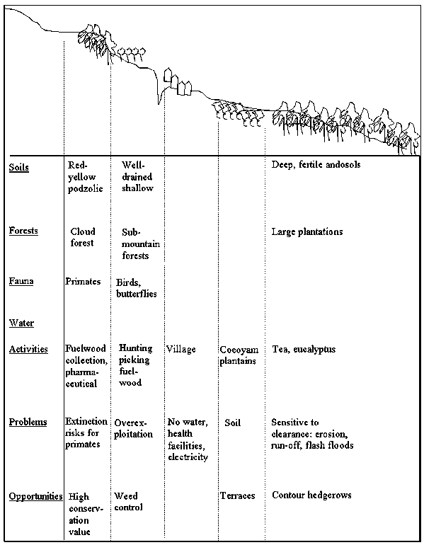
Figure A3.3 Historical timeline for one community in Biodivia District
|
Year |
Events |
|
1954 |
Little cropland, mainly pasture and wasteland in village |
|
1964 |
Pasture land and forests conversion to crops |
|
1980 |
Immigration of strangers |
|
1985 |
Pasture land and forests conversion to crops accelerate |
|
1990 & recent years |
Fallow period shortening |
|
Recent years |
Severe erosion |
Figure A3.4 Trend line for long-term rainfall
Figure A3.5 Seasonal calendar of rainfall and evaporation in Biodivia District
The major steps for planning the use of the above tools are described in Box A3.2 below.
Advantages and limitations
· The advantages of informal methods lay on their high flexibility (they can be adapted to the purpose of the investigation, they are able to provide specific types of information); low demand of resources, particularly time and budgets; ability to ensure comprehensiveness of data and information collected by providing answers to the who, what, when, where, how, why questions; capacity to involve the stakeholders to think systematically about their problems and possible solutions.
Box A3.2 Steps to consider for the use of informal tools
|
1. Checklist of the features to consider and any associated issues to be discussed about each of them (e.g. physical infrastructure, water sources, cropping systems, woodlands, land tenure systems, grazing areas, infrastructures, and so forth). 2. Identification of the participants. It is important that they represent the group you wish to consult. 3. Explain the purpose of the tool to the groups of participants. 4. Equipment. Almost all the tools can be used with simple equipment. Maps, calendars, lines, can be produced on the ground, on the floor, or on paper. The choice will depend on the circumstances and on the preferences of the participants. 5. Drawing. The use of the tools should involve the participants, who must agree on the variables placed in the maps, calendars, trend lines and time lines. 6. Copy the findings on a piece of paper. If the maps, calendars, lines have been drawn on the floor or on the ground, they will have to be copied when they are completed. 7. Discuss the final product. The findings should be used as the basis for discussion on the features considered. Notes on the discussion will help to better explain and understand the outcome of the exercise. The final copy of the tools used should be approved by the participants and one copy should be left with them. It is worth pointing out that all the tools presented are a means for analysing the issues and questions of the checklist and not just an output. Therefore, while drawing the maps, lines, calendars, the facilitators should also stimulate the participants to express their views on the problems and opportunities. |
· The limitations of these methods are that: they are not advisable to create databases that can provide valid quantitative estimates (e.g. information such as 25 percent of the population is suffering from the effects of air pollution); the selection of key informants is often biased and elitist in the sense that there is a tendency to select key informants on the basis of their status (village élites) rather than on their knowledge and experience; distortions of judgements are possible if interviewers are not experienced and have a preconceived approach in the interpretation or recording of the answers provided by the key informants.
To conclude, in general, the optimal approach to information and data collection would be to combine formal methods with informal methods. The relative importance of the two sets of methods will depend on a number of criteria such as the objectives pursued, the skills of the analysts, the equipment available, as well as the time and budget allocated.
by
K.C. Lai, Wang Yiqian and Li Shengzhi
Within an administrative area such as a county, practical questions concerning natural resources and the environment would include issues such as: what and where are existing resource endowments, including their quantity, quality, and characteristics; current usage of various resources, and their environmental status and trends; who are the interest groups or stakeholders in a given resource use issue; the causes and effects of resource degradation; relationships between different resource uses and users; and whether there are potential conflicts of interest and tradeoffs in development objectives. Knowledge of these would assist in determining development priorities and setting of environmental goals.
Put another way, the analysis should help answer questions of a what, which, where, when, who, why, and how (and sometimes "what if") nature. In this case study, such questions are given sharper focus by using an analytical scheme that paid special attention to: a) planning theme and utility of the analysis; b) type and scale of analytical unit; and c) cause-effect relationships affecting the environment.
Planning Theme and Utility. Within the ambit of decentralised rural development planning and management, the practical utility of environmental analysis at county level and below are to be found largely in the following thematic areas:
i) area strategic planning;
ii) development project planning[47]; and
iii) development facilitation, including information exchange, coordination, conflict resolution, and mediation/ negotiation processes.
The foregoing provides an organisational basis for the analyses which follow. The latter are grouped according to their utility under strategy planning or development facilitation themes. Eight sets of analytical tools have been selected. These are shown below page together with the main question being addressed.
|
Analytical Tool |
Main Question Type |
|
|
Group I. County and sub-county Environmental Strategy Planning: |
||
| |
Tool 1. Baseline establishment: Inventory of Natural Resource Inventory & Environmental Hazards (Xichang County) |
What, Where, When |
|
Tool 2. Resource Suitability & Depletability Analysis (Qionghai Lake & Luojishan Nature Area) |
Which, Where, How |
|
|
Tool 3. Resource Use and Stakeholder Analysis (Qionghai Lake) |
Who, What |
|
|
Tool 4. Socio-economic Analysis at Community and Household Levels, (Upstream and Downstream Villages) |
Who, What, Why, How |
|
|
Tool 5. Pressure-State-Response and Problem Tree Analysis (Qionghai Lake & Related Sub-watersheds) |
Why, What, Who |
|
|
Group II. Development Facilitation: |
||
| |
Tool 6. Conflict-Complementarity and Policy Tradeoffs Analysis of Stakeholders, Qionhhai Lake |
Who, How |
|
Tool 7. Resource-Power-Influence Analysis of Stakeholders, Qionghai Lake |
Who, What |
|
|
Tool 8. SWOT (Strengths, weaknesses, opportunities, and threats) Analysis of Qionghai Lake Management Bureau |
What, Why |
|
|
Item |
Description |
|
Location |
400 km southwest of Chengdu, 27° and 28° N and around 102° E. |
|
Area |
2655 km2, including Qionghai Lake 28.82 km2, |
|
Demography |
Population 530,000, of Han Chinese and Yi and other ethnic groups (18%), living in 5 urban administrative districts, 7 towns & 29 townships, with 232 villages; 12 townships solely or predominantly Yi minority. |
|
Climate |
Subtropical to cold and warm temperate; influenced by landforms & altitude; high insolation (>2400 hrs); annual rainfall 1013 mm (intense summer rains, 60% during May - Aug); average annual temperature said to be 17° with Jan 9.5° & July 22.6° and 272 frost free days (data needs careful interpretation due to altitude factor). |
|
Physiography/ Soils |
Four regions may be discerned: 1) Anning Valley, Qionghai Lake Basin; 3) Western Mountainous zone; and 4) Eastern (north and south) mountainous zone. Elevation from around 1500m to > 4000m (50+ peaks). Hills and mountains occupy 80% of area. Glacial features at higher elevations include cirques, lakes, moraines boulder clay; hillsides, valley walls often unstable and predisposed to landslides, land collapse. Geology of quaternary period, with seven soil groups: 1) paddy soils (11.6%); fluvial deposits (1.0%), purple soils (11.1%), red soils (29.7%), yellow brown soils at 2400 - 2700m (18.0%), brown soils above 2700m (12.4%), & "sub-alpine" soils (18.2%). |
|
Rivers & lakes |
Main river Anning (catchment 1676 km2, annual flow 3,562m cu m), with 20 main tributories of which 4 with subwatershed >100 km2; Yalong river western boundary; Qionghai lake 28.82 km2 and 300m cu; 5 hotsprings; >10 sites with hydro-power potential >100Mw. |
|
Agro-climate Zones |
Falls within Sichuan's "Southwest Mountainous Sub-tropical Agricultural, Forestry, Livestock Agro-climatic Zone"; nominally under Xichang-Huili paddy-wheat two season subzone, but influence of landforms and altitude variations mean some areas more akin to Daliangshan mountainous temperate forestry, livestock and agriculture subzone (as in Xide and Puge counties). |
|
Agricultural Zones |
Divided into three "Integrated Agricultural Planning Zones", namely: 1) Anning-Valley-Qionghai Lake grain,vegetables, fish, pigs, fruit & tobacco; 2) Maoniushan (Yak mountain) & Mpoanshan forestry, livestock & crops; and 3) Luojishan & Beishan (north mountain) forest, livestock, crops & tourism zones. The livestock bureau has its own planning zone demarcations (Anning Valley pig, poultry, milch catlle & buffalo zone & Western Plateau and mountains yak, goats/ sheep & cattle zone). |
|
Present Landuse |
Of 2655 km2: 58.6% forestland, 19.4% cultivated (51.2% paddyland/ 48.8% dryland), 1.5% orchards, 6.0% pastureland, 4.3% water bodies, 6.6% wasteland; settlements/ mining, industry & infrastructure 3.5% (1993 data based on remote sensing). Sectoral/ statistics bureau data based on annual village reports generally underestimate cultivation extent. There had been much wasteland conversion to agricultural & other uses over the past 15 years (currently only 7020 ha wasteland remaining, compared to 17,600 ha in 1993, and 34,000 ha in 1982). |
|
Flora & Fauna |
Variations in altitude have meant a range of natural vegetation, from sub-tropical forest species (to conifers, evergreen broadleafs, and montane conifers. Important ecosystems are found in the high mountains and in lakes and rivers, especially Luojishan nature area and Qionghai Lake. In Luojishan are found many species of flowering and non-flowering plants, including rhododedrons, camellias, azaleas, rough gentians, lilies and winter jasmine (30 species are listed under state protection), in addition to many types of medicinal plants, ferns and edible wild mushrooms. There are also a wide variety of wildlife, including 60 types of mammals, over 250 types of birds, and various reptiles and amphibians (among those listed under state protection are the lesser panda, stump-tail monkey, forest musk deer, gorals and pangolins). In Qionghai Lake and the rivers of Xichang, including the Anning River, are to be found many different aquatic species, including edible water plants, fish, and freshwater shrimp. Some 70 fish species (falling under the suborders Cyriniformes, Ciluriformes, Cyprinodoniformes and Symbanchiformes) have been listed. The Cyriniformes, which include the carp families Cyprinidae and Cobitidae are by far the most numerous, making up over 50 of the species listed. Some species (e.g. "Xichang Baiyue" or Anabarilus liui Chang and "Qionghai Baiyue" A. qionhaiensis) come under the provincial protected list. |
|
Minerals |
Rich deposits of rare earth minerals, tellurium, vanadium-titanium magnetite, besides iron ore in the city and nearby counties. Bureau of Mines at various levels have survey data on quantities and locations, but such data are generally departmental secrets. |
|
Farming systems |
Lowland areas in Anning Valley and around qionghai Lake: rice-wheat system with other food and cash crops (tobacco, broad bean, soya bean) in rotation or as intercrops; pigs and small number of draft oxen, buffalo. Fruit orchards (pear, peach, pomegranate, apple) largely on former wasteland, but maize and tobacco also observed on latter. Mulberry & silk production is on the increase in recent years. Some lakeside farmers also carry out artisanal fishing, shrimping, and fish pond farming. Large scale commercial stocking & harvesting (10 boats) of exotic silver fish (yinyue), lobster, crab in lake. Highland areas: above around 2000m, buckwheat, oats, barley, potato, with wild pepper (Xanthoxylum bungeanum Maxim) as valuable tree crop; livestock important and include sheep, goats, cattle, and pigs, generally under free range. |
|
Economy |
Agriculture mainstay of population, but secondary & tertiary sectors have grown in importance to 29% & 46% of GDP. Economic growth 14.7% per year during 1991 - 96 and 8.8% throughout 1980s. Tourism an important industry, with 17,000 hotel beds & 350 tourist restaurants, & 18.6m visitor-transactions/ yr. in 1997. Per capita income in 1997 of 1860 yuan; but distribution uneven, with pockets of poverty especially in highland areas (with township average per capita incomes of 1000 yuan). |
|
Development Strategies & Projects |
Long term social and economic perspective plan to year 2010 prepared; multi-pronged development from natural resource & technology based development, including tourism, commerce & trade expansion. Industrial structure to shift to construction and metallurgy, away from food processing, chemicals, & light industries. Planned GDP growth of 10.6% - 11.1% till year 2010. Planning Commission has listed 58 investment projects for funding under 9th FYP, including 21 for agriculture (livestock, commercial aquaculture, horticulture, cut flowers), & 6 for tourism. World Bank funded Anning Valley Project will assist with components for food grain, duck, rabbit, mulberry/ silk, & fruit production. |
|
Resource Degradation & Environmental Pollution |
Over 40% of Xichang subject to erosion & nearly 23% under severe to violent erosion (1987 data). Sedimentation & debris flow of rivers & lake: Anning river affected by high sediment load from Xide county, at confluence with Shensuihe near Lugu town; Qionghai lake area and depth decreasing (annually by 0.3% & 0.75m, respectively) due to sediment/ debris flow from Guanba & Erjang rivers (currently 500,000 tons/year from both rivers). Erjang ceased being perennial river from early 1980s. Eutrophication of Qionghai lake during 1980s & early 1990s from high levels of N & P, ascribed to fish cage farming in lake, over-the-water restaurants & surface runoff from agriculture & wastewater from around 1000 lakeside resident households. Fish stocks declining, while water hyacinth (Eichhornia crassipes Mart, Solmes.) on lake surface now a weed problem. Anning river dowstream of Haihe polluted by Xichang urban wastewater. |
|
Government Responses |
Prefecture & city governments undertook various legislative, administrative, and regulatory/ enforcement measures to address Qionghai Lake degradation issues. Qionghai Lake Management Bureau (QHMB) established in 1994 empowered to protect lake environment, including subwatersheds of Erjang & Guanba river up to boundary with Zhaozue county. QHMB responsible for control/ and regulation of fishing, industrial, and tourism related activities. Apparent water quality improvement since 1995 (BOD down from 0.91 to 0.68 mg/l; total N down from .52 to .22 mg/l; & P down from .15 to .02 mg/l). Various environmental enhancement projects also identified covering wastewater system, afforestration, economic forestry, debris flow control structures, and city garbage disposal & treatment. |
|
Community Responses |
Land degradation affects both lowland & highland communities. Lowland households affected by floods/ debris flow contribute labour and cash/ kind to build & strengthen levees (preventative costs) and to rehabiliate areas damaged from time to time. Loss of irrigation water from rivers drying up compensated by pumping from lake. Highland communities often lose arable and residential land through gullying, soil erosion and land slumping/ debris flow. They appear to have own strategies to tackle these e.g. by planting local trees/ shrubs (e.g. local names Beyang, Jimu, and Gerba) to stabilise steep slopes & gullies; fallowing of plots & crop rotation to maintain fertility, organic matter, some plots left uncropped when rainfall appears too intense & conditions deemed hazardous for planting. Trees are often planted as a "saving" towards future cremation requirements. (Much more work is however needed to understand in depth the community & farm household economic & socio-cultural goals & strategies). |
In accordance with prefecture and city governments' "Qionghai Lake Protection Regulations" of 1997, the Qionghai lake Management Bureau (QLMB) was given the responsibility for protection and integrated management of:
a) Qionghai Lakes's waterbody;
b) its immediate shoreline up to 200m inland;
c) Erjang subwatershed (falling entirely within Xichang county); and
d) the portion of Guanba subwatershed that falls within Xichang county (the portion under Zhaozue county, by definition, being excluded).
Within the protected zone, QLMB has control over fisheries and tourism activities, building construction, water resource quality, and protection of wildlife/ aquatic plants and forestry trees. Measures instituted since QLMB was established include:
* Banning of fish cage culture in the lake, along with licensing of fishing boats, line fishing, and shrimp fishing (licenses are issued to individuals from only seven villages, with a 2-month open season for fishing boats);
* Strict control on lakeside development, including compulsory relocation of the 'over the water' restaurants inland, and closure of offending restaurants;
* Mandatory installation of water treatment for the battery factory; and closure of the fertiliser factory;
* Tree planting along the 200m wide strip of shoreline; and
* Restricting the use of motorised boat traffic; all tourist boats are now battery or manually operated.
Exhibit 3 indicates the checklist of bio-physical and socio-economic information on Xichang city submitted to various local government agencies prior to the field visit to the county. A checklist of institutional items was similarly prepared, and formed the basis of discusssions with local officials, including the Qionghai Lake Management Bureau,[48] which had recently been set up with overall responsibilities for environmental protection of this resource.
|
Main Items |
Sub-items |
|
Physiography and agro-ecology |
Land forms, geology, main rivers/ lakes, altitude ranges, physiographic regions, agro-ecological zones/ agricultural planning zones. |
|
Climate |
Sunshine hours/ intensity, rainfall pattern & temperature regime (by months/ years/ zones), accumulated temperatures above 5° and 10°. |
|
Soils and natural vegetation |
Main types, characteristics, usage, soil fertility status, zonal distribution. |
|
Flora and fauna |
Ecological systems, forest species, incld. non timber forest species, unique & protected wildlife & aquatic species within area, biodiversity aspects; special attention Qionghai Lake and Luojishan nature reserve. |
|
Water resources |
Ground and surface water, quantities and quality of main sources, lake & river sedimentation/ silt load, pollution extent, distribution over years/ months/ seasons; hydro-electricity generation and potentials. |
|
Mineral resources |
Quantities and qualities of deposits, present level of exploitation, practices used, by sub-regions. |
|
Tourism resources |
Scenic, recreational, historical, cultural, scientific sites, current usage, tourism facilities, tourist flow, sources, transactions, and trends. |
|
Environmental degradation/ natural disasters |
Occurence of floods, droughts, debris flow, mudslides, soil erosion, hailstones, wind and insect damage (qualitative and quantitative data), and earthquakes. |
|
Pollution |
Air/ water pollution indicators, main pollution sources, current situation and trends, strategies by government and communities to address problems, actions taken. |
|
Demography/ settlements |
Human settlements, total and rural population, number of households, ethnic groupings, distribution (by townships/ physiographic regions), population density, growth rate. |
|
Social & economic indicators |
Gross Domestic Product, distribution by sectors (agriculture and livestock, mining, industry, primary, secondary, tertiary), major state enterprises, town and village enterprises, average household incomes, poverty regions; incidence of poverty households, state assisted "distress & five-guarantee" households, literacy rates by regions; preliminary information on farm household types. |
|
Land use |
Area extent (% distribution) of agriculture (irrigated & rainfed crops), orchards, forestland (various categories), pastures, wasteland, water bodies, etc. (based on State system of classification, Territorial Bureau and sectoral sources); check area trends, incld. wasteland conversion for agriculture/ orchards & other uses. |
|
Agriculture & food production |
Area of food crops & economic crops, production levels, average yields, livestock types, numbers & annual offtake/ sales, freshwater fisheries (lake, rivers, pond production), sectoral production targets, trends, with special attention on crops like tobacco. |
|
Land tenure/ management typology |
Household responsibility & other systems of land tenure/ management & of user rights, individual households, collective/ cooperative/ commercial organisations, state operated, & others (various uses and types of arrangements). |
|
Development strategies & projects |
Area development strategies (long & medium term, sectors), 9th FYP, existing, approved/ pipeline development projects, proposal/ project ideas (includ. sectoral, environmental protection proposals); World Bank Anning Valley Project details. |
|
Resource or Hazard |
General Description |
|
A) Renewable resources: |
|
|
1. Sunshine and precipitation |
Sunshine >2400 hrs per year; annual rainfall 1013mm (but lowest recorded of 691mm in 1962, and highest of 1471mm in 1968), mainly night rains (intense summer rains, 60% during May - Aug); average annual temperature said to be 17°, with mean Jan 9.5° & July 22.6° and 272 frost free days. These data may understate more extreme temperatures at higher altitudes. |
|
2. Arable land * |
51,630 ha of which 63% in flat areas, 37% in mountainous areas. Around 83% of latter is of medium to low productivity (grain yields below 100 kg/ha). Around 38% of flat land is of high productivity (grain yields 400 kg/ mu or more). Land suitability/ land quality data not available. Note that much wasteland has been converted to agricultural & other uses over past 15 years (currently only 7020 ha wasteland remaining, compared to 17,600 ha in 1993, and 34,000 ha in 1982). |
|
3. Soils |
7 main groups: 1) paddy soils (11.6%); fluvial deposits (1.0%), purple soils (11.1%), red soils (29.7%), yellow brown soils at 2400 - 2700m (18.0%), & brown soils above 2700m (12.4%), sub-alpine soils (18.2%). Subdivided into 13 sub-groups, 18 families, 80 types (series?). |
|
4. Water |
a) Main river Anning (catchment 1676 km2, annual flow 3,562m cu m), with 20 main tributories of which 4 with subwatershed >100 km2; b) Yalong river western boundary, with 2 rivers >100 km2; c) Qionghai lake 28.82 km2 and 300m cu m; d) 5 hotsprings sites; e) More than 10 sites with hydro-power potential >100 MW. |
|
5. Forests |
Primary & secondary (including aerial seeded) forests, which together with bushland, sparse woodlands & immature trees total 155,590 ha (58.6% of total area of Xichang). Trees species range from sub-tropical forest species (to conifers, evergreen broadleafs, and montane conifers. Forestry bureau has extensive list of indigenous and exotic species endemic or introduced (e.g. Pinus, Eucalyptus) into different locations. (Not clear if quantitative data available). Local people also have knowledge of wide range of trees and shrubs, used for fuel, timber, gully protection, and as condiments (e.g. local names like Ji-mu, Be-yang, and assorted forests species of "jah-mu"). There was insufficient information to correlate with scientific names. |
|
6. Flora & fauna (biodiversity) |
Natural: Important ecosystems are found in the high mountains and in lakes and rivers, especially:
Agricultural: Local varieties of soya bean and broad bean ("Dabu Fudo"), peach variety ("Huangxin Tao"); indigenous Jenchang duck (much in demand for processing/ wind drying); Jenchang pony (prowess for hill climbing). |
|
B) Non renewable: |
|
|
Minerals/ fossil fuels |
Rich deposits of rare earth minerals, tellurium, vanadium-titanium magnetite, besides iron ore in the city and nearby counties. (Quantity & locations secret). No known deposits of petroleum or coal. |
|
Scenic, historical, cultural, scientific sites |
Qionghai lake scenic area; Lushan mountain; Huanglianguan rock sulptures; Luojishan nature area multi-coloured lakes, waterfalls, primary forest vegetation, also Tang dynasty buddhist sites; quaternary geology & biodiversity of Luojishan are a living museum. |
|
C) Main hazards (existing & potential) |
|
|
|
a) Natural: Some landforms in Xichang are fragile, as its geological history predisposes Xichang to soil erosion (especially Guanba river), landslides on hillslopes and debris flow along valleys (especially Erjang river). This is exacerbated by the intense summer rains (60% falling between June & August, as much as 100 mm/day (highest recorded was 135.7 mm in a day in Aug 1951). Xichang lies on southern extension of Xianshuihe fault system (Anninghe and Xiaojiang faults) hence prone to earthquakes (6 ocassions of magnitude > Richter 6.5 since 1920s). b) Human induced: lakeside commercial & domestic wastewater discharge in Qionghai Lake; Xichang urban wastewater discharge into Haihe, thence Anninghe; fish cage farming in Qionghai lake (ceased from 1995) & surface runoff of agricultural fertilisers into Qionghai lake; water hyacinth Eichhornia crassipes growth on lake surface; conversion of wasteland on hill slopes around Qionghai Lake for crops, especially maize & tobacco; introduction of exotic species (crabs, crayfish, "yinyue" silverfish Neosalanx taihuensis, carps) & fine-mesh net harvesting of "yinyue" in Qionghai Lake; overstocking of ruminants livestock; mining & industrial effluent into river system; farming on hillslopes overlooking lake & in highlands, some > 25°; tourism development in vicinity of pristine nature areas in Luojishan. |
* The term "arable land" is used somewhat loosely here, as wasteland is sometimes converted to arable use, while there had been conversion of arable land for industrial and urban uses. The present cultivated land is expected to remain relatively constant in the near and distant future, hence may be a proxy for arable land.
|
Natural Resource |
Depletability Status (Yes?) |
If conditional renewable: natural processes involved & management systems needed: |
||
|
Non renewable & non recyclable |
Renewable & non-conditional |
Conditional renewable |
||
|
Earth Minerals |
Yes |
|
|
|
|
Solar Energy |
|
Yes |
|
|
|
Qionghai Lake: |
||||
|
- Wasteland/ dryland soils in hills around lake |
|
|
Yes |
Soils planted to annual crops (maize, tobacco) on slopes over 30% (16°) generally subject to soil erosion. Continuous cropping & use of chemical fertilisers can degrade soil physically & chemically, & lead to P & K runoff into Qionghai Lake. Conversion of wasteland to crop needs careful monitoring. Use of conservation farming systems, including inter-cropping, rotations, grass strips/ hedge barriers & terracing need to be considered. |
|
- Natural fish/ shrimp species |
|
|
Yes |
Complex aquatic ecology, with different food chains and subzones within lake (e.g. top/ bottom feeding, breeding areas). Offtake of local carp (Cyprinidae) species "bailian" & "hualian" & shrimp from lake may be subject to increasing pressures from commercial stocking of "yinyue" silverfish & crabs & crayfish, methods of which require careful review. Despite legislation, national protected Anabarilius species (Xichang & Qionghai "baiyue") find their way to the market. Enforcement efforts need to be supplemented by better information to local people. Ecological studies of species dynamics also required. |
|
Luojishan Nature Area: |
||||
|
- Scenic landscape |
|
|
Yes |
Multi-coloured lakes, thermal waterfalls, geological sculptures are renewable only if not physically and visually damaged by commercial developments & human usage. To preserve pristine nature of key sites i.e. not lost to future generations, strict enforcement of infrastructure and building construction guidelines & recreational usage is vital. |
|
- Natural flora & fauna |
|
|
Yes |
Complex forest ecology with many "niches" for different species, impossible to reproduce through human planting. Commercial exploitation to be prohibited, but low pressure indigenous people harvesting & gathering (e.g. medicinal herbs, mushrooms, wild honey) is often sustainable due to practices & knowledge over many generations. |
|
Natural Resource Category |
Usage |
Order of Suitability |
Limiting Characteristics & conditions of use * |
Opportunities for enhancing suitability* |
|
Qionghai Lake: |
||||
|
Wasteland/ dryland soils in hills around lake |
Food crops/ tobacco production |
Medium |
Only on slopes < 16° (30% slope), to minimise erosion risk; use of grass strips/ hedge barrier or terracing may be necessary, depending on soil erodibility; good ground cover & high organic matter needed to prevent soil degradation |
Use of conservation farming practices, including agro-forestry to increase ground cover, provide green manure/organic matter & enhance fertility |
|
Fruit orchards |
High |
Only on slopes < 25° (45% slopes), but terracing is generally necessary; soil depth must be adequate for tree root zone |
Legumes & grass species introduced to improve ground cover & provide green manure; farmers trained to build & maintain terraces, to good standard |
|
|
Water body of lake |
Commercial stocking & harvesting of aquatic species |
Medium |
Aquatic eco-system should not be upset by exotic species; natural biodiversity to be safeguarded; hence species selection & harvesting methods require careful review. |
Reduce N & P inflow to lake, minimise backflow from Haihe river |
|
Boating & water sports |
Low |
Only wind, battery & human powered; no motorised boats. |
|
|
|
Beachfront scenic area |
Hotels |
Medium |
Minimum 40m from water edge, no high rise, own wastewater treatment installation |
Suitable trees & ornamental plants strategically placed |
|
Industrial park |
Low |
Minimum 80m from water wedge, no chemicals & wastewater discharge to lake; air or noise pollution within permissible limits (e.g. 50 dBA by day & 40 dBA by night) |
As above, plus proper access roads & wastewater disposal system |
|
|
Luojishan Nature & Scenic Area: |
||||
|
Outside nature reserve |
Holiday village (intensive use area) |
Medium |
To be outside buffer zone bordering nature reserve area; constructions should keep aesthetics in mind/ not be visually obtrusive; list of permissible activities to be drawn up & strictly enforced (including noise levels e.g < 40 dBA) |
Zoning study to identify sensitive/ fragile areas & extent of buffer zone required; thorough consultations with local inhabitants (around 1000) |
|
Within nature reserve (1000 km2) |
Eco-walks, scientific studies (extensive & restricted use area) |
High |
Requires buffer zone separating nature area from above; no motor vehicles, low volume hiking only; all applicants for visit to be carefully vetted & tours supervised |
As above |
* For illustration only. Local planners may insert other limitations and conditions in accordance with national, provincial or local guidelines; opportunities may similarly be indicated.
|
Type of Use |
Extent of Use |
Primary Stakeholder (those affected) |
Secondary Stakeholders (those affecting): |
|
Domestic Water Supply |
Xichang urban centre, including lakeside towns and townships: 195,000 people approximately |
Xichang urban residents City water company |
|
|
Irrigated rice farms |
Pumping to 14,000 mu of rice farms around lake |
Paddy farmers in Hainan, Chuanxin, Gaojian & Xijao townships |
a) Within Xichang County: QLMB (Qionghai Lake Management Bureau) * |
|
Dryland farmers |
Crops on village allocated dryland plots & converted wastelands/ pastureland/ forest land |
Farmers in hills around lake, especially Daxin township Upstream farmers of Erjang & Guanba subwatersheds (Xichang & Zhaozue) Farm households with boats & license |
Environmental Protection Bureau Xichang Planning Commission/Finance Bureau Forestry Bureau Agricultural Bureau |
|
Licensed Artisanal Fishing |
800 boats (2 month season/ year) 300 line fishermen (year round) 200 shrimp fishermen (year round, restricted hours per day) |
Individuals with licenses Farm households with licenses |
Tobacco Development Office Xichang Tourism Office Territorial Bureau |
|
Commercial Fish Stocking/ Harvesting |
10 boats open water harvesting of Yinyue silverfish (no quantitative data) Stocking/ harvesting of crayfish and crab (no quantitative data) |
Private commercial company Private joint venture company |
Soil & Water Conservation Office b) Outside Xichang County: |
|
Tourism |
18.6 million visitor-transactions in 1997, including hotels (17,000 beds), shops, restaurants (350), transportion & entertainment. |
Tourists from within & outside Sichuan Lakeside restaurant/ hotel owners |
Various county & township government departments, Zhaojue county (including Hongxin township) |
|
Human Settlement |
Residential houses at immediate shoreline of lake |
Residents in Hainan, Chuanxin, Gaojian & Xijao townships |
|
* Under the Regulations (Local Legislation) for Qionghai Lake Environmental Protection, passed by the city and prefecture governments, functions and responsibilities of the following government agencies have been transferred to QLMB: Horticulture and Aquatic Products Bureau; Traffic Office (boats); Forestry Bureau (within 200m of shoreline, and the area under the Erjang and Guanba watersheds). Along with this was their relinquishing of revenue collection (licenses, fees) to the QLMB.
|
Item |
Downstream Community: Hetao & Zhongluo Villages |
Upstream Community: Shengli Village (Wojuba hamlet) |
|
I. General Township Information: |
||
|
Township |
Hainan township (with 4 villages in all) |
Daqing township (with 3 villages in all) |
|
Population |
5826 |
3719 |
|
Altitude (asl) |
1510m - 1560m |
2000 - 2500m |
|
Cultivated land |
0.84 mu/ capita |
2.17 mu/ capita |
|
Fishing Activities |
Around 80 fishing boats; approx. 180 households involved in fishing, including shrimping; also 700 mu fishponds (various carps) |
No fishing |
|
Income/ capita (1997) |
1830 yuan on average |
1193 yuan on average |
|
Ethnic groups |
Han Chinese (93.3%), Hui muslim (5.7%) & others (1.0%) |
Mainly Yi minority (98.8%). |
|
II. Village & Farm Household System Information (Preliminary): |
||
|
Land resource & utilisation |
Cultivated land between 0.8 - 1.0 mu mu/ capita; mostly paddyland, with up to 10% dryland; around 90% of paddyland used for grain, remainder for intensive vegetables & oilseed; wasteland converted for orchards (plum, peach, pear) & maize (300 mu converted in Hetao since 1990). There is no pastureland, & some livestock grazing is in state forestry areas. |
Around 3 - 4 mu/ capita; includes low quality land, some converted from pastureland, wasteland, & forestland allocated to households; all dryland crops & no irrigation; crop-fallow practised, but fallow periods decreasing, now as short as one year. Animals grazed on crop residues, fallow land, wasteland & hill slopes. |
|
Crops & farming system |
Generally a) Wheat-rice rotation, wheat intercropped with broad bean (soya bean also grown); rice irrigated by pumping from Qionghai lake; b) Maize on dryland areas & on wasteland; c) Diversified production of vegetables (cabbage, chillies, garlic), oilseeds & tobacco, on portion of paddyland; c) Orchards of peach, plum, persimmons, & pear. |
Main summer crops of buckwheat (subsistence), potato (home consumption, pig feed & for market), with smaller quantities of oat & barley; winter crops only of radish. With decreasing fallow, maintaing soil fertility appears to be now a problems. Sichuan pepper trees (prickly ash or Xanthoxylum bungeanum Maxim) are grown as cash crop. |
|
Livestock |
Pigs (mostly for fattening/ finishing), kept in pig pens), poultry, including ducks & geese; few sheep; some buffalo kept for ploughing. |
Pigs (home consumption & sale as piglets), goats, & sheep kept; adult sows mainly under free range, but some households beginning to build housing for pigs & goats/ sheep; some chicken, few cattle also kept; pig swill cooked for piglets. |
|
Fishing |
Some (< 10%) farm households also in artisanal fishing & shrimping. Fish caught include: "Baiyue, Qingyue, Hongyen, Lenyue, Betiao, Wuyue" mainly carp species. |
Not applicable |
|
Aquatic plants harvested |
"Lianjao" (Trapa natans var. bispinosa) & edible "Bienjacai" collected from lake; "Haicai", & "Jachao" no longer available since early 1990s. |
Not applicable |
|
Trees |
Few trees within village, but 1500 mu of village collective forest in Hetao (planted to Pinus Yunnanensis pine), timber species. Harvesting is subject to forestry law (no felling unless equivalent amount planted). |
Many households have small fenced woodlots (mainly of "Beyang & Jimu"); as saving for use in cremation. But unclear user rights in view of forestry law, and hesitancy in tree planting on hill slopes near village. |
|
Fuel supply |
Some households purchase coal, but most use fuelwood: mainly branches, underbrush, leaf litter, collected from protection forestry areas of hills around lake. |
No coal bought; fuelwood cut or collected from local shrubs & bushes ("ja-mu"), saplings, dead branches, from around village & also from state forestry farm (mainly pine) 4 km away. Collected by women household members. |
|
Household types |
Production of subsistence & "duty" (tax & compulsory sale) rice & wheat, by all households, plus various other crops or livestock. Many have poultry & some non-farm income sources; a few are in trading/ business, while some households also fish. Subcategories of households by economic activity are: 1) Subsistence & duty wheat & rice with pig fattening; 2) As in 1) plus intensive vegetables; 3) As in 2) plus fruit orchards (usually plum & peach; 4) As in 1) plus fishing; and 5) As in 1) except only goats kept, with no pigs. Some economic differentiation in village, with specialised households emerging, but not very pronounced. In general better off households with wasteland invest in pear (5 years to production), while poorer households invest in plum or peach (3 years to production), while poorest households only plant maize on wasteland. |
All households have subsistence buckwheat, potato, & oats, with Sichuan pepper as cash crop; pigs, sheep/ goats common to all households. Very little off-farm employment income. Little economic differentiation within village. |
|
Main problems & constraints * |
Bio-physical: Debris flow from Erjang topping levees & destroying surrounding farmland (3000 mu affected, with 300 mu destroyed in 1996); height of riverbed increasing & levees need repairs & building up yearly; since 1984, river no longer perennial & unuseable for irrigation, hence pumping from Qionghai Lake necessary. |
Bio-physical: Soil Erosion, gully formation & land collapse during intense summer rains lead to loss of cropland & residential land in village; effective means of stabilising gullies not available (lack planting materials; forestry species such as Yunnan pine, though fast growing found not suitable in village situation) |
|
Socio-economic: Land shortage a major production constraint; for fishing households, catch now much smaller & fewer varieties than ten years ago. Funds shortage affect choice of investment on paddyland, dryland & wasteland. |
Socio-economic: Land productivity low & some households have grain shortage; converting pastureland to crops has led to livestock feed problems; some households have labour shortage (poverty households with only aged members); most have difficulty getting off-farm income; most have limited knowledge of Chinese language & few with even full primary education; relatively high cost of education (350 yuan/ year per child) outside village |
|
|
Possible household goals & strategies * |
a) Agricultural production: to meet needs for 1) subsistence & 2) household "duty" commitments of "Zenggo & Denggo" (tax in kind & mandatory sales to state); & for cash income. b) Debris flow problem tackled by households contribution in kind & labour to annual repairs & maintenance of levees. c) Some poaching of fish outside license arrangements to supplement incomes likely. |
a) Crop production to meet subsistence needs, for livestock feed, & for cash income (agricultural tax is at fixed rate, now at 8 yuan per mu); small individual woodlots mainly as saving for cremation needs; b) Soil erosion & gullying tackled by planting local trees/ bushes e.g. "Beyang", "Jimu", & "Gerba" (local name), but lack suitable planting material & propagation methods; c) Plots on more fragile slopes left uncropped when rains thought to be too intense during season; d) Soil fertility replenishment by crop-fallow system; some households beginning to keep animals in shed & collect manure for crops (mixed with pine twigs & shrubs). e) Some better off households have migrated to other areas. |
* Preliminary impressions only, will require further investigation.
|
|
Shengli Village (Upstream Yi Community) |
|
Hetao/ Zhongluo Villages: (Downstream Han Community) |
|
Year |
|
Year |
|
|
1954 |
Collectivisation of agriculture begins; little cropland, mainly pastures & "wasteland" in village |
|
|
|
1964 |
Collective village feeding, households required to harvest fuelwood from natural forests |
|
|
|
|
|
1968 |
Qionghai Lake flooding of village |
|
|
|
1970 |
Qionghai Lake flooding of village |
|
1980 |
Households allocated individual plots; grain deficit in many households |
|
|
|
|
|
1981 |
Pumping station constructed, guaranteed irrigation |
|
1982 |
Pastureland & forests conversion to crops accelerate |
|
|
|
|
|
1984 |
Erjang river no longer perennial flow; dry from Feb - June; no irrigation possible |
|
1995 |
Major earthquake |
|
|
|
(recent years) |
Fallow period shortening; Loss of farm plots through soil erosion; Some households have migrated from village |
1996 |
Major flood & debris affected 3000 mu and destroyed 300 mu of paddy in Zhongluo (left bank) |
|
1998 |
Severe erosion, gullying & land collapse |
1998 |
Right bank levee of Erjang breached in August ** |
|
|
|
|
|
* Based on recollection of local residents; will require further corroboration.
** Information received by telephone from Xichang.
|
Environmental Issue or Problem |
Pressure |
State |
Response |
|
Deteriorating Water quality of Qionghai Lake |
Commercial, residential & fish farming activity: a) Over the water restaurants, lakeside hotels & restaurants wastewater discharge; b) Around 1000 lakeside households wastewater discharge; c) Feedstuffs used in open water fish cage culture |
Eutrophication of lake; by mid 1990s, lake water quality indicators were below National Standard Class 2 for domestic water supply, but trend recently reversed |
a) Prefecture Peoples' Consultative C'ttee commissioned survey of environmental problems (1993); b) Prefecture & city governments legislative action (1997 Regulations); c) Establishing Qionghai Lake Management Bureau (1995); d) Establishing Prefecture & City level Leading Groups for coordination of Qionghai Lake Protection e) Strict enforcement of regulations by Environmental Protection Agency (including closure of restaurants & factories) |
|
Qionghai Lake Sedimentation & Debris Flow |
a) Conversion of wasteland/ hills for crops around lake and in Guanba & Erjang subwatersheds, leading to soil erosion b) Natural geology predisposing factors & Debris flow on Erjang River |
a) Lake area decreasing by 0.3% per year; land encroachment at Guanba river mouth 5 - 10 m/year b) Depth declining by 0.75 m per year c) Debris flow & sediments into Qionghai lake 500,000 tons per year d) Floods & debris flow destroy farmland in villages of Hainan township (300 mu in 1996) |
Farmers contribute labour each year for repairs & improvements to levees an both banks of river; there is also collective forestry planting on hills overlooking Hetao village, and planting of fruit trees by farmers on wasteland around lake, but rights of tree harvest and relative profitabilty of fruit growing could affect future activities |
|
Invasion of lake by exotic species |
a) Local farmers introducing new plants into streams and ponds in Xichang |
Water hyacinth expanding over lake area (no quantitative data) |
City government pay for manual removal from fishing boats (100,000 yuan budgeted for 1998), but no other actions. |
|
b) Commercial companies stocking lake with exotic fish, crab, crayfish |
(Possibility of) fish ecological balance affected, loss of biodiversity (negatively or positively, but no clear data) * |
No apparent perception of potential hazards by governmental agencies |
|
|
Loss of Cropland from Erosion by Upstream Communities |
a) Hill slope cropping by farmers without conservation practices b) Farmers' practice of diverting streams for village & home use, along with natural geology & rainfall conditions lead to gully formation |
Crop plots (& sometimes house plots) lost from sheet erosion and land slumping |
Farmers attempt to stabilise gullies with local trees ("Baiyang, Jimu") and leaving crop plots fallow whenever rainfall deemed hazardous in a given season; better off farmers may migrate to other areas. |
* There is inadequate information on this aspect. However, artisanal fishermen suggest local fish population may be affected negatively (fish size and number of fish species) by the fine-net fishing methods used for "yinyue" silverfish (Neosalanx taihuensis) introduced into the lake by the commercial company.
|
Stakeholders |
Urban residents |
Lakeside paddy farmers |
Farmers in hills around lake |
Upstream farmers in two subwatersheds |
Artisanal fishing households |
Commercial "silverfish" silverfish company |
Crayfish & crab Joint venture company |
Lakeside Restaurants |
Qionghai Lake Management Bureau |
Other government agencies * |
|
Urban residents |
|
|
|
|
|
|
|
|
|
|
|
Lakeside paddy farmers |
OO |
|
|
|
|
|
|
|
|
|
|
Farmers in hills around lake |
OO |
CM |
|
|
|
|
|
|
|
|
|
Upstream farmers in two subwatersheds |
OO |
CX |
OO |
|
|
|
|
|
|
|
|
Artisanal fishing households |
CM |
CM |
OO |
OO |
|
|
|
|
|
|
|
Commercial "silverfish" company |
CM |
OO |
OO |
OO |
CX |
|
|
|
|
|
|
Crayfish & crab Joint venture company |
CM |
CX |
OO |
OO |
CX |
CX |
|
|
|
|
|
Lakeside Restaurants |
CM |
OO |
OO |
OO |
CM |
CM |
CM |
|
|
|
|
Qionghai Lake Management Bureau |
CM |
CM |
CX |
CX |
CM |
UC |
UC |
CX |
|
|
|
Other government agencies * |
CM |
CM |
CM |
UC |
OO |
CM |
CM |
CX |
CX |
|
(Possible relationships: CX = conflicts of interest; CM = complementary; OO = no apparent relationship; UC = unclear as yet).
* Refer to Tool 5 for information on various government agencies, also secondary stakeholders.
|
POLICY DECISION OR ADMINISTRATIVE ACTION |
Development Objective or Anticipated Impact (Incremental Change) * |
||||||||
|
City government tax revenue |
City government expenditure |
Local employment |
Area income |
Crop production |
Gross value agriculture/ industrial output |
Water quality indicators (e.g. N, P, BOD, COD) |
Eco-system indicators (e.g. bio-diversity) |
Other |
|
|
1. Close down lakeside fertiliser plant |
|
|
|
|
|
|
|
|
|
|
2. Mandatory effluent treatment facility for battery factory |
|
|
|
|
|
|
|
|
|
|
3. Close 130 over the water restaurants |
|
|
|
|
|
|
|
|
|
|
4. Ban open water cage fish rearing |
|
|
|
|
|
|
|
|
|
|
5. Shorten open season for artisanal fishing |
|
|
|
|
|
|
|
|
|
|
6. Ban motorised tour boats |
|
|
|
|
|
|
|
|
|
|
7. Shoreline tree planting on 200m strip |
|
|
|
|
|
|
|
|
|
|
8. Stricter control on lakeside hotel construction |
|
|
|
|
|
|
|
|
|
|
9. Strengthening levees on both banks of Erjang river |
|
|
|
|
|
|
|
|
|
|
10. Issue permit for use of open water for commercial fish enterprises ** |
|
|
|
|
|
|
|
|
|
* Quantitative or Qualitative; analysis should include projections for future years, where appropriate.
** For exotic species such as "yinyue" silverfish, crab (from Tai lake), and crayfish (from Australia) stocking and harvesting.
|
Primary Stakeholders & Resource use category |
Any formal license, title or legislative provision (Yes/ No) |
Stakeholder power or access score Strong (S), Moderate (M), Weak (W) |
Comments |
||
|
Informal power/ influence |
Financial power/ resources |
Skills, knowledge/ information |
|||
|
Xichang Urban residents: Domestic water |
No |
M |
M |
M |
Though not formalised, city government is obliged to provide acceptable quality water for urban consumption; informal power rests in the number of commercial businesses & government officals resident in urban centre |
|
Lakeside paddy farmers: Irrigation water (Hainan, Chuanxin, etc.) |
No |
W |
M |
M |
Food production goals & irrigation revenue means farmers receive direct or indirect government support in maintaining irrigation water resource |
|
Farmers in hills around lake: Farming on dryland, converted wasteland (Daxin) |
Yes |
M |
M |
W |
Permits for land conversion granted by Territorial Bureau/ Forestry Bureau (requires confirmation); Tobacco development Office may provide support for expansion of tobacco cultivation |
|
Upstream farmers of Guanba & Erjang subwatersheds: Farming on dryland, converted, pastures, wasteland |
Yes |
W |
W |
W |
Farmers pay agricultural tax of 7 yuan/ mu for village allocated land, but tax revenue may not reflect full extent of land use for crops, especially in more remote areas; farmers have own production/ land protection strategies, but hampered by skills and resource availabilty (e.g. cash for cement, gully planting materials) |
|
Licensed individuals: Open water fishing |
Yes |
M |
M |
M |
Licenses at 640 yuan/year per boat (yuan 150 & yuan 120 per year for shrimp & line fishing); some poaching is apparent & reflect local peoples' continuation of informal open access traditions |
|
Commercial & joint venture companies: Lake for fish stocking & harvesting |
Yes |
S |
S |
S |
Commercial companies have 5 year licenses for open water useage; joint ventures involve Ethnic Minority Affairs Office participation, hence have political clout |
|
Lakeside residents: lake as sink for wastewater |
No |
M |
M |
W |
Rights of use from tradition; government plans for ring sewer for implementation only from year 2005. |
(Assessment: S = strong; M = medium; W = weak)
|
Secondary Stakeholder |
Legislative/ administrative authority for resource management |
Financial resources/ programme budgets * |
Role in resource management functions: |
Comments |
||
|
Enforcement |
Planning |
Coordination |
||||
|
Qionghai Lake Management Bureau (QLMB) |
S |
M |
S |
M |
S |
Has own revenue base from license fees & supported by high level coordination committee at city & prefecture level; no control links over sectoral bureau programmes, who have their own funding. |
|
Environmental Protection Bureau |
S |
W |
S |
W |
M |
Functions include monitoring of point & non point source pollution; some roles overlap that of QLMB; low revenue base from fines/ levies & sale of environmental monitoring data. |
|
City Planning/ Finance Bureau |
S |
S |
W |
M |
S |
Has strategic control over specific sectoral development programme budgets, but own expenditures limited. |
|
Agricultural Bureau |
M |
S |
W |
M |
M |
Food production targets & funding under 9th FYP can impact on farmer land use decisions. |
|
Tobacco Development Office |
M |
S |
W |
W |
W |
Expansion of tobacco production under 9th FYP can impact on land use & fuelwood demand. |
|
Xichang Tourism Office |
M |
W |
W |
W |
M |
Largely sector-specific interests, few staff & resources. |
|
Forestry Bureau/ Farm |
S |
M |
S |
M |
W |
Roles for protection & commercial timber forestry; quandary under present forestry law linking tree harvesting to planting stipulations; little technical input into agro/ social forestry at farm household level. |
|
Soil & Water Conservation Office |
M |
W |
W |
W |
M |
Formed out of Water Conservancy & Hydro-power Bureau very recently; few resources & programmes as yet. |
|
Territorial Bureau |
S |
M |
W |
M |
M |
Has acted as integrative force in agricultural sector resources assessment & zonal planning; but along with Forestry Bureau, being affected by recent national bureaucratic reorganisation. |
* Note that access to information and availabilty of technical, planning, and management skills also convey power and influence to the stakeholder. These aspects should be included in more detailed analyses of this kind.
|
Criteria |
Strengths |
Weaknesses |
Opportunities |
Threats (Hazards or Constraints) |
|
Role definition & scope of responsibilities |
a) Control & enforcement functions for use of qionghai lake resources clearly defined; b) There are also provisions for coordination through high level prefecture & city level multi-sectoral committees. |
a) Depends on cooperation of other government agencies, through coordination by high level prefecture & city committees; these meet only intermittently & may be too unwieldy for effective communication/ information exchange; b) Strategic planning function not apparent; c) Role in protecting aquatic eco-system integrity of lake, including bio-diversity, not sufficiently clear. |
Scope for enhancing role in information exchange, & greater publicity on environmental goals and objectives; acting as repository of routine information on lake environmental quality & resource use/ sustainability indicators. |
QLMB has taken over many functions of other government agencies; may not find ready future cooperation from sectoral bureaus, each with own development priorities (e.g. Forestry Bureau timber industries); despite workings of high level coordinating committees, conflicts of interest possible. |
|
Legal authority |
Authority clearly defined by 1997 Prefecture & City Legislations/ Regulations. |
No provision by local government legislation for greater involvement of local people & private organisations in environmental protection (e.g. citizens complaint mechanism). |
Making more provision for participation of general public in environmental problem identification, monitoring/ feedback & in devising solutions. |
Local government regulations may sometimes clash with national/ provincial legislations e.g. forestry law; incentives for sound resource management may be affected. |
|
Area coverage |
Fairly comprehensive physical system basis for management of water body, shoreline & relevant subwatersheds of Guanba & Erjang |
Whilst all Erjang subwatershed is covered by the 1997 legislation, the upper reaches of Guanba that fall within Zhaozue county lies outside jurisdiction of QLMB. |
QLMB to liase via prefecture government with Zhaozue county & Hongxin township regarding future upstream environmental protection initiatives. |
Zhaozue & Hongxin development priorities in upstream areas may conflict with QLMB environmental protection objectives. |
|
Financial resources |
Own revenue generation from licensing/ fees from fishing, tourism boats, fines, etc. |
No funding for addressing upstream resource degradation root causes; weed clearance of water hyacinth cost 60,000 yuan in 1996, expected 100,000 yuan in 1998. |
Future funding for comprehensive management of lake & the two relevant subwatersheds to be planned for, by first formulating long range natural resource & environmental protection strategic plan. |
Areas of concern may already fall within development programme areas of sector agencies, who may or may not accord priority to QLMB plans and activities. |
|
Human resources |
Numerical staff strength of 18 at present appear reasonable. |
Additional technical skills on strategic planning for overall lake & subwatersheds system, and eco-system approach to resource management needed. |
Enhancing technical & conceptual skills through training & study visits for QLMB personnel on wetlands & aquatic eco-system management & on watershed management. |
Availability of suitable manpower for training unclear. |
|
[40] Stephen Mink (1993) has
analysed the interactions between poverty and environment. The Economic
Commission for Latin America and Caribbean (1991), also addressed the issues of
poverty and population interactions with the environment. Myrdal (1968),
Chambers (1986), and Bartelmus (1986) all addressed poverty-sustainable
development interactions. [41] Ostrom (1995). [42] Valuable contributions to the analysis of environmental policy instruments are: Coase (1960), Baumol and Oates (1975), Buchanan and Tullock (1975), Pearce and Turner (1990), Carlson et al. (1993), Panayotou (1994), OECD (1995). [43] People are asked to respond to stimuli in laboratory conditions. [44] For a detailed discussion on biases in CVM, see Mitchell and Carson (1989). [45] For more details the readers are referred to FAO (1998). [46] This case study (FAO, 1998) was prepared as part of FAO’s training and technical support activities in decentralized rural development planning in Sichuan Province in 1998. [47] Project planning activities are often linked to county strategies, and may be "nested" within the latter. [48] Checklist items included: current local legislation for environmental protection; organisation, authority/ power and enforcement; personnel/ staff strength & capacity; type and nature of plans; development budgets, revenue & expenditures; inter-sectoral relationships, cooperation & coordination mechanisms; composition of government "leading groups", frequency & effectiveness of meetings; extent of community participation. |
![]()
![]()
![]()
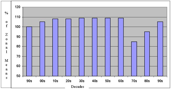
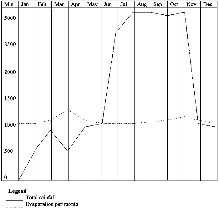