![]()
![]()
![]()
Drainage water management is normally concerned with reducing the amount of drainage water and with managing its disposal. However, this aim is more complex than it appears. Drainage is practised to maintain aeration in waterlogged rootzone and/or to leach excess soil salinity to sustain agricultural production. The drainage water generated must then be managed for reuse purposes where it is of suitable quality and finally discharged or disposed of. The discharge of drainage waters in watercourses may have impacts ranging from beneficial to deleterious. The disposal of drainage water into wetlands, lakes, rivers and coastal waters entails considerations about the quantity and quality allowable and indeed sometimes required to maintain desirable ecological conditions and functions of that given water body.
|
Box 10: Maximum reuse and minimum disposal of drainage water in the Nile Delta, Egypt, based on maintaining favourable salt balance Monitoring data showed that in 1993-94, 12 500 million m3 of drainage water were disposed and 3 400 million m3 were officially reused for agriculture (DRI, 1995). The effective reuse was 3 000 million m3 assuming an LF of 12 percent. Data analysis showed that 13 300 million m3 of drainage water with a salinity level of less than 4.7 dS/m (the official maximum salinity level allowable for reuse) was theoretically available for reuse. The required LF for this salinity level was estimated to be 0.19 (EPIQ Water Policy Team, 1998). Therefore, the effectively re-usable quantity of drainage water for consumptive use would be 10 800 million m3, leaving 4 700 million m3 (12 500 + 3 000 million m3 - 10 800 million m3) of drainage effluent to be disposed. |
To sustain irrigated agriculture, the maintenance of favourable salinity levels is the major concern in assessing the minimum drainage disposal requirements. When aimed at maximizing source reduction or reuse of drainage water, minimum leaching is required to maintain favourable salt balances in the rootzone. The minimum LF depends on the salinity of the irrigation water and the salt tolerances of the crops grown. Box 10 shows an example from the Nile Delta, Egypt.
Minimum disposal requirements also depend on the requirements of downstream water uses. For example, many inland fisheries are currently threatened because of increasing water pollution, degradation of aquatic habitats and excessive water abstraction (FAO, 1999a; and Barg et al., 1997). With the increase in environmental awareness, there is increasing pressure to preserve sufficient water for aquatic environments, habitats and biodiversity. For example, wetlands are considered to be among the world's most valuable ecological sites. They form the habitat for many species of plants and animals. Wetlands perform various other vital functions, e.g. water storage, flood mitigation and water purification. Wetlands also provide economic benefits, of which fisheries, recreation and tourism are among the most important. These functions, values and attributes can only be maintained if the ecological processes of wetlands continue functioning (Ramsar Convention Bureau, 2000). If the ecological processes in the wetlands depend on drainage water inflow and if the functions of the wetlands are to be sustained, the minimum drainage discharge will depend on the quality and quantity of drainage water required for maintaining the ecological processes. Box 11 shows how the minimum drainage discharge or maximum reuse potential for agriculture is estimated based on sustaining the fisheries in the coastal lakes of the Nile Delta, Egypt.
|
Box 11: Minimum drainage discharge requirements for maintaining the freshwater functions of the Northern Lakes, Egypt The Northern Lakes (Maruit, Edko, Burrulus and Manzala) are located adjacent to the Mediterranean Sea and they are no more than 2 m deep. The lakes are economically important as they support a large fishery and many fish farms. Lake fisheries produce 52 percent of the nation's total fish production and provide employment to 53 000 anglers. The lakes are also ecologically important as they support a large bird population and serve as a stopover for migratory birds. As the lakes are also the sink for a large part of the drainage and wastewater from the Nile Delta prior to outflow to the sea, the quality and quantity of the drainage water discharge can threaten these two main functions of the lakes. Lake Maruit is heavily polluted and suffers from eutrophication due to drain discharges carrying industrial and municipal waste. The surviving fish species are limited and provide only a non-commercial food source to local residents. As the lake would need large quantities of freshwater inflow to recover its ecology, the consensus is that this lake will continue its salinization process and eventually lose all fish production and its ecological value (EPIQ Water Policy Team, 1998). The other three lakes depend on drainage outflow to maintain their brackish water environment. Based on the assumption that Lake Maruit will loose its function as a freshwater lake for fish production, the Drainage Re-use Working Group of the EPIQ Water Policy Team conducted an analysis of the required minimum drainage water outflow to lakes Edko, Burrulus and Manzala. For continued fish production, the salinity levels in the lakes should be maintained between 5.5 and 6.25 dS/m. Lake Edko, Lake Manzala and Lake Burrulus have salinity levels of 2.1, 3.2 and 5.6 dS/m, respectively. To maintain maximum salinity levels, the drainage outflow to Lake Manzala and Lake Edko can be reduced to a maximum 50 percent of the present outflow level. However, the outflow to Lake Burrulus is already on the low side and cannot be reduced any further. The minimum drainage discharge based on sustained freshwater lake fisheries is 8 500 million m3 per year. This is 3 800 million m3 more than the reuse potential based on maintaining the salt balance in the Nile Delta for agricultural production. Hence, less water is available for reuse if the lake fisheries are to be maintained. |
Depending on the location, hydrology and topography of the drainage basin (and the ecology and environmental conditions of receiving water bodies), drainage water might be disposed to open surface water bodies, e.g. rivers, lakes, outfall drains, and oceans. The oceans are often regarded as the safest and the final disposal site for agricultural drainage water. This is true unless drainage water is contaminated with sediments, nutrients and other pollutants and the disposal site is in the vicinity of fragile coastal ecosystems such as mangroves and coral reefs. Therefore, at the point of discharge, pollution may be of much concern. In general, oceans have significant dilution or assimilative capacity. However, this is also limited in many cases especially in enclosed and semi-enclosed seas. Inland drainage water disposal to freshwater bodies such as lakes and rivers requires care. Rivers are normally used for different water use purposes requiring certain qualities of water, while the accumulation of salts and other pollutants in freshwater lakes threatens ecosystem functions and aquatic life.
Disposal into rivers or oceans is not always possible. In closed drainage basins, alternative disposal options need to be sought. The options for closed hydrologic basins include evaporation ponds, deep-well injection and integrated drainage management systems. Drainage water management in closed basins presents numerous environmental and water quality challenges.
Disposal in wetlands offers much potential but at the same time there are also accompanying constraints. Wetlands might be either natural or specially constructed for drainage water reuse. In the former case, the maintenance of ecological functions depends on the quality and quantity of drainage water inflow.
The main aim of safe disposal in freshwater bodies such as lakes and rivers is to protect beneficial downstream water uses. Rivers and lakes are normally multifunctional (municipal drinking-water, industrial water, fishing, recreation and agriculture) and have an intrinsic ecological value. Furthermore, rivers feed lakes, floodplains, wetlands, estuaries and bays. To protect these functions, it is necessary to determine the assimilative capacity of the river and, where necessary, of connected or receiving ecosystems. It is also necessary to identify the constituents of concern in the drainage water in order to determine its discharge requirements. Moreover, the effects on sediments, riparian habitats and floodplains warrant consideration.
The discharge requirements should specify the maximum allowable concentration of each constituent of concern and the volume of drainage water that will be acceptable. Concentration is the water quality parameter normally used in drinking-water standards or for the health of aquatic animals and plants. However, placing only concentration limits on discharge might encourage dilution and inefficient water use. Where both concentration and load limits (product of water concentration and water volume) are enforced, they tend to promote efficient water use. For example, in the San Joaquin Valley, the discharge limitations into the San Joaquin River include limits on concentration of specific constituents and their loads. The concentration limitations include limits on salinity, boron, selenium and molybdenum in order to protect downstream water quality for domestic and agricultural uses and to safeguard the environment. To discourage dilution or inefficient water usage, load limits for these constituents are enforced for the discharge of irrigation return flows into the San Joaquin River.
Table 22. Allowable subsurface drainage discharge and drainable area into the River Yamuna
|
Month |
Allowable
discharge |
Drainable area |
||
|
|
Effluent salinity (dS/m) |
|||
|
|
6 |
10 |
6 |
10 |
|
June |
0.9 |
0.5 |
5 000 |
3 000 |
|
July |
25.4 |
14.4 |
146 000 |
83 000 |
|
August |
47.6 |
27.0 |
274 000 |
156 000 |
|
September |
6.5 |
3.7 |
37 000 |
21 000 |
|
October |
3.0 |
1.7 |
17 000 |
10 000 |
Source: FAO, 1985a.
The assimilative capacity of the receiving water body varies from place to place and from time to time depending on numerous local conditions. These include climate and physical conditions and the upstream uses. The River Yamuna in Haryana, India, provides an example of seasonal differences in disposal opportunities. During the dry winter season, November-March, the flow of the River Yamuna is less than 50 m3/s. From July to September, during the monsoon season, the flow exceeds 1 000 m3/s with a peak of 1 150 m3/s in August. The salinity of river water during monsoon is less than 0.2 dS/m. The river's high flow and low salinity during the monsoon period provides an opportunity for the disposal of saline effluents. As the water table shows a marked rise during the monsoon season, major pumping for drainage takes place between July and September. Table 22 shows projections of the amounts of subsurface drainage water that could be disposed into the River Yamuna. The criterion used was that the resultant salinity of the water in the river after mixing should be less than 0.75 dS/m. A significant drainable area with salinity problems can use the River Yamuna as a possible drainage outlet between July and September (India case study in Part II).
Figure 42. Map of the Grasslands subarea and drainage water discharge
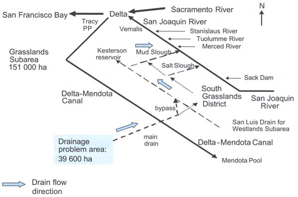
Drainage from the Grassland subarea in the San Joaquin Valley provides another example of the possibilities and constraints of river disposal. Figure 42 presents a schematic map of the area (39 600 ha) that has opportunities to discharge its irrigation return flow into the San Joaquin River. However, there are some constraints as dictated by the waste discharge requirements set by the Central Valley Regional Water Quality Control Board (CVRWQCB, 1999).
In the recent past, irrigated agriculture discharged its irrigation return flow into the North and South Grasslands District, an entity devoted to wetland habitat for private duck clubs and birdwatching as well as pastureland for grazing animals. Since the discovery of selenium poisoning of waterbirds at Kesterson Reservoir from subsurface drainage waters conveyed from the Westlands Water District, drainage from the problem area is no longer discharged into the Grasslands Water District. Instead, it is discharged directly into the San Joaquin River at Mud Slough via the San Luis Drain and a bypass.
Figure 43 shows that although their flows are minor, Salt Slough and Mud Slough are major contributors of TDS and selenium in the lower reaches of the San Joaquin River. Thus, the CVRWQCB has placed monthly waste discharge requirements for Salt Slough and Mud Slough (CVRWQCB, 1998). The water quality objectives were established to protect downstream water uses as well as export water to southern California. The salinity water quality objective for Vernalis, a benchmark station on the river, is 1 dS/m for a 30-day running average from 1 September to 30 March, and 0.7 dS/m for a 30-day running average from 1 April to 31 August. The boron objective is placed from Sack Dam to Merced River, the reach above and below Salt Slough and Mud Slough, at 2.0 mg/litre monthly mean for the year with a maximum of 5.8 mg/litre for a given month. The selenium water quality objective is placed on Salt Slough and Mud Slough at 5 mg/litre, 4-day average, to protect aquatic biota and a maximum annual load of 3 632 kg to control mass emission. Exceeding the specified allowable loads of salt and selenium results in monetary fines to the dischargers. The selenium load is the most difficult for irrigated agriculture to meet.
Figure 43. The significance of irrigation return flows from Salt Slough and Mud Slough on the quality of the San Joaquin River system
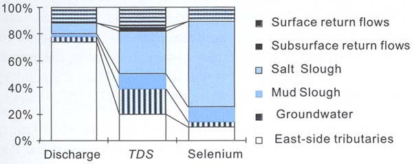
Source: CVRWQCB, 2000.
Generally, rivers continually cleanse themselves. In most cases, lakes do not have this capacity as they may not have an outlet, or flow volume from the lake is limited. The disposal of drainage water into lakes might cause substantial long-term problems. Thus, it involves special considerations. There are numerous examples from all over the world where disposal of agricultural drainage water into freshwater lakes, often in combination with reduced freshwater inflow, has added to the development of immense and catastrophic environmental problems. Examples include Lake Chapala in Mexico, Lake Manchhar in Pakistan, Lake Biwa in Japan, and other lakes where significant effort is required to halt environmental degradation.
In inland drainage basins without an adequate outlet to a river, lake or sea, or where disposal restrictions prevent discharge into rivers and lakes, one of the few options is disposal of drainage effluent into constructed evaporation ponds or natural depressions. Discharge into natural depressions has been practised for centuries. The impounded water is dissipated by evaporation, transpiration and seepage losses. Disposal into constructed ponds is practised worldwide. The planning and design of evaporation ponds have to take account of numerous environmental problems. These include:
waterlogging and salinization problems in adjacent areas resulting from excessive seepage losses;
salt-dust and sprays to areas downwind of the pond surface during dry and windy periods, which might damage vegetation and affect the health of humans and animals; and
concentration of trace elements that might become toxic to fish and waterbirds because of bioaccumulation in the aquatic food chain.
The following examples from Pakistan, the United States of America and Australia highlight the opportunities and constraints of evaporation ponds.
In Pakistan, evaporation ponds have been constructed under the Salinity Control and Reclamation Project (SCARP) VI for the disposal of the highly saline drainage effluent from the irrigated areas on the fringes of the desert located 500-800 km from the sea. SCARP VI has employed vertical drainage to lower and maintain the water table at a depth of 2.3 m over an area of 152 000 ha. The area is underlain by groundwater with an EC ranging from 15 to 34 dS/m. A total of 514 tubewells, ranging in capacity from 30 to 90 litres/s, have been installed to pump out 600 million m3 annually. This water is discharged into open surface drains for conveyance to the evaporation ponds for final disposal. Allowing for conveyance losses, the drainable surplus to be disposed of is an estimated 540 million m3. It was anticipated that the resultant salinity in the drainage water would be of the order of 30 dS/m (NESPAK-ILACO, 1981).
The design of the evaporation ponds assumed a percolation rate of 280 mm per year (half of the estimated value) and an evaporation rate of 1 700 mm per year (against the observed value of 1 800 mm). The surface area of the ponds was estimated to be 27 300 ha. The evaporation ponds were developed in a desert area on the fringes of the Indus Plain just beyond the canal command area of the project. The pond area is characterized by interdunal depressions (with highly sodic soils), between longitudinal sand dunes 4-9 m high. The underlying groundwater is highly brackish. For the development of the evaporation ponds, dykes were provided across the saddles and channels cut across the dunes to form a series of interconnected ponds. The ponds that have been developed so far have a surface area of 13 350 ha and a distance of 1-3 km separates their edges from the irrigated area. The drainage effluent is discharged into the evaporation ponds by gravity flow from one drainage system and pumped from another drainage system further downslope.
The operation of the ponds started in 1989 and by May 1998 it was reported that water had spread over a pond surface area of 4 200 ha (IWASRI, 1998). The period of operation has been too short to establish a state of equilibrium. However, soon after ponding started some irrigated areas close to the ponds were severely affected by waterlogging. This could be ascribed to significant seepage losses from the ponds generating a zone of high groundwater, obstructing or retarding the natural subsurface drainage from the irrigated lands (NRAP, 1991). The seepage affected area had grown to about 4 000 ha in 1993, even though the tubewell pumping was effective in lowering the water table to 3 m in parts of the drained area.
Between 1972 and 1985, 28 evaporation ponds were constructed covering an area of about 2 800 ha receiving about 39 million m3 annually of subsurface drainage from 22 700 ha of tile drained fields (SJVDIP, 1999d). Basinwide, the pond area is about 12 percent of the total area drained. Most of the ponds are located in the Tulare subarea, a closed basin in the San Joaquin Valley. The salt concentration in the waters discharged into these ponds ranged from 6 to 70 dS/m with an annual salt load of 0.88 million tonnes, about 25 percent of the annual salt load accumulating in the more than 0.9 million ha of cropland.
The concentration range of selenium, the principal constituent of concern, is from 1 to over 600 ppb. A selenium concentration of 2 ppb is considered the upper limit for aquatic life in ponds as selenium tends to bioaccumulate 1 000- to 2 500-fold in the aquatic food chain. Selenium is toxic to waterbirds as it substitutes for sulphur in essential amino acids resulting in embryo deformities and reduced reproduction rates. Ten ponds (with a surface area of about 4 900 ha) are active and managed by seven operators. The other ponds have been voluntarily deactivated due to the high costs of meeting the waste discharge requirements and mitigation measures for bird toxicity. The state/regional water quality regulatory agency ordered the closure of several ponds because of the unacceptable toxic effects of selenium on waterbirds from selenium present in the impounded drainage waters.
The waste discharge requirements for pond disposal define the requirements and compliance schedules designed to discourage wildlife use of evaporation ponds and/or provide mitigation and compensation measures to offset adverse effects on birds.
The evaporation ponds are constructed by excavating the soil to form berms with side-slopes of at least 3:1 (h:v). The pond bottoms are unlined but compacted, the pond environs are kept free of vegetation, and a minimum water depth is maintained at 60 cm. Migratory waterbirds attracted to the pond site are to be scared off, and bird diseases kept under control. Compliance monitoring includes seasonal drainage water and sediment selenium concentrations, and biological monitoring of birds for abundance and symptoms of toxicity. When adverse selenium impacts are noted, off-site mitigation measures must be implemented with either compensation or alternative habitats as guided by approved protocols and risk analysis methods. Compensation habitats are constructed to compensate for unavoidable migratory bird losses by providing a wetland habitat safe from selenium and predators. Alternative habitats are year-round freshwater habitats immediately adjacent to contaminated ponds in order to provide dietary dilution to selenium exposure. In spite of the stringent waste discharge requirements and associated high costs, farmers and districts in the Tulare subarea use evaporation ponds for drainage water disposal basins. This is because there are no opportunities for off-site discharge into the San Joaquin River or other designated sinks for drainage waters. Evaporation ponds are the only economic means of disposal of saline drainage in the Tulare-Kern subareas.
The Salinity Drainage Strategy of the Murray-Darling Basin Commission imposes constraints on the amount of river disposal. Export of saline drainage water via pipelines to the sea has been considered but studies show that this option is relatively uneconomic compared to other disposal options (Leaney et al., 2000). Saline disposal basins have been an important measure for the disposal of drainage effluent and will remain so. In the Murray-Darling Basin in 1995, 107 basins were actively used with a total area of more than 15 900 ha, a total storage capacity of more than 113 million m3 and an annual disposal volume of more than 210 million m3/year.
The use of regional-scale basins was a common approach in the Murray-Darling Basin. Regional basins were developed on the most convenient sites from an engineering standpoint. This sometimes had detrimental environmental, socio-economic and aesthetic impacts. These concerns together with the new opinion that beneficiaries of irrigation should be responsible for their own drainage management led to the development and use of local-scale basins. These basins can be in the form of on-farm basins which are privately owned and located on individual properties. They can also be privately or authority-owned community basins shared by a small group of properties. The choice between on-farm or community basins should consider physical, environmental and sociopolitical issues as well as costs. Economic analysis has shown that there is generally little difference in cost between the two options (Singh and Christen, 2000). Therefore, environmental and social considerations should outweigh the negligible economic differences in the choice between on-farm and community basins in the Murray-Darling Basin.
The first step in the design of an evaporation pond is to determine the volume of drainage water in need of disposal. The volume of drainage water depends on the land use, climate, irrigation practice and type of drainage system. The planning stage needs to include an assessment of the salinity of the drainage water as well as a full analysis for trace elements, nutrients and pesticides to prevent possible accumulation to toxic levels (Leaney et al., 2000). Trace elements in drainage water disposed into the evaporation ponds include arsenic, boron, molybdenum, selenium, uranium and vanadium. The trace element of most concern in California for impounded drainage waters is selenium. The influent selenium is subjected to a number of reactions such as evapoconcentration, seepage losses, reduction of oxidized species of selenate (Se+6) and selenite (Se+4) to selenide (Se-2) as well as elemental selenium (Se0), methylation by microbes and plants and volatilization as dimethylselenide (DMSe), and adsorption of selenite to pond bottoms (Tanji and Gao, 1999). Approximately 60 percent of the mass of selenium influent appears to remain in the ponded water, the balance being immobilized or lost by the above mechanisms.
The hydrologic balance of evaporation ponds is relatively simple. The inputs into the pond include drainage water from cropped land, rainfall and, where applicable, water pumped into the pond from a perimeter drain installed to intercept seepage water from the pond. The outputs consist of evaporation, non-recovered seepage losses and transpiration from aquatic vegetation. An example of the hydrology of a typical pond system in California is: 1.91 m/year drain influent; 0.022 m/year precipitation; 1.87 m/year evaporation; 0.39 m/year seepage; and 0.46 m/year influent from the perimeter interceptor drain that collects both pond seepage losses and shallow groundwater.
The required pond area can be calculated on the basis of this hydrologic balance and depending on the depth of water layer that is to be maintained in the pond. When the salinity of the water in the evaporation ponds increases, the evaporation rate from the water surface decreases as a result of a decrease in water vapour pressure. The design of the pond area needs to take this aspect into account. Evaporation rates in ponds have been measured. The pond evaporation can be estimated using an empirical correction factor (Y) and ETo. (Johnston et al., 1997):
E = Y(Eto) (21)
in which Y = 1.3234 - 0.0066 EC for water between EC 14 and 60 dS/m.
Seepage losses from evaporation ponds depend on soil, geohydrological and topographical conditions. Site selection is very important for preventing excess seepage losses. Depending on the hazards that excessive seepage might occur and depending on the environmental regulations, lining and a seepage collection system may be required in order to ensure that there will be no contamination of groundwater, and to prevent waterlogging in adjacent areas. The availability of materials should determine the type of lining. Research from Australia has shown that a small amount of controlled seepage of around 0.5-1.0 mm/d is required to maintain evaporative disposal capacity, as evaporation rates decrease substantially under hypersaline conditions (Leaney et al., 2000). This implies that basins should be located preferably within the drained area. Where the basin is sited outside the limits of the drainage system, it should be located within a specific salt containment area equipped with effective interception and recycling works.
For those pond systems deemed to be hazardous to waterbirds, pond operators are required to establish alternative and compensation habitats. Alternative habitats using freshwater are built within the functional landscape of evaporation ponds to provide year-round habitat to dilute the diet to the feeding birds. Compensation habitats are located outside the functional landscape of the evaporation ponds (about 5 km) during the breeding season.
Disposal by injection into deep aquifers is a process in which drainage water is injected into a well for placement into a porous geologic formation below the soil surface (Lee, 1994). The oil and gas industries use deep-well injection to dispose of waste brine. In California, the United States of America, deep-well injection technology has been used for over 60 years for the disposal of oil field brines. The technology could potentially be applied for the disposal of agricultural drainage water provided the conditions of the receiving geologic formation are adequate, there are no environmental hazards and the costs are not prohibitive. The main environmental concern is leakage from pipes and confining aquifers. Drainage effluent can contaminate freshwater zones through leakage.
The drainage and aquifer water should be compatible, as the mixture should not produce precipitates, which clog the wells. Furthermore, the receiving geologic formation should have sufficient porosity and thickness to receive the injected water. If water containing nitrate is injected into aquifers containing organic matter and ferrous iron, the growth of nitrate reducing bacteria might clog the pores of the receiving formation as they accumulate (Westcot, 1997).
The Westlands Water District, California, the United States of America, carried out a prototype deep-well injection to dispose of up to 4 000 m3/d of drainage water (Johnston et al., 1997). The drainage water was to be in injected into shale and sand formations 1 554 and 2 164 m, respectively, beneath the ground surface. The well was drilled to a total depth of 2 469 m at a cost of about US$1 million. The casing was perforated with 13 perforations per metre from depths of 2 245 to 2 344 m and from 2 411 to 2 414 m in the Martinez geologic formation for a total length of perforations of 102 m. Following the recovery of some natural formation water samples, an injection test was conducted. The fluid injected was irrigation water filtered through a 0.5-micron filter and treated with 2-percent potassium chloride and a chlorine biocide. The filtered and treated water was injected through a 4.75-cm tubing at a rate of 12 litres/s for a total of 175 000 litres of water injected. Then, a 48-hour pressure fall-off test was conducted that revealed the permeability of the geologic formation was 12 mm/d. This permeability value is too low to achieve the desired injection rate of 44 litre/s. In spite of the filtration and chlorination of the injected water, plugging of conducting pores occurred in the shale. The United States Environmental Protection Agency rejected a request for permission to conduct a second injection test in the sandy, more permeable formation above the shale. The Westlands Water District abandoned this method of disposal.
![]()
![]()
![]()