![]()
![]()
![]()
Guidelines for preparation of a Country report: State of land, water and plant nutrition resources
These guidelines constitute a general framework to assist a systematic compilation of information for the reports. The guidelines should ensure that country reports will be comparable along the lines of common themes, such as land use and land degradation, state of water resources, hot spots and bright spots. The guidelines are exhaustive: they are presented in the form of a checklist of items from which a selection can made depending on relevance and availability of information in specific situations. If the information is not available or is not relevant to the country or the part of the country considered it should not be included in the report or may be added at a later date. In certain cases the FAO approach (e.g. agro-ecological zoning) has been suggested. Where this information is not available, data gathered using other kinds of methodologies should be presented. The guideline will be updated from time to time as more experience is gained.
The report is a `live' document. The aim of the report is to bring together the most up-to-date information on land water and plant nutrient resources. Where possible, information should not be presented as static data but in the form of trends, preferably in a visual format (maps, tables, charts, images). The motto is to have short but suggestive text and a lot of simple but "attention catching" visual objects. Internet lends itself perfectly for this kind of presentation. Hypertext enables the information to be easily modified: items can be added or deleted at any time and with much ease. As new information becomes available and topical issues change (discussed in the challenges/viewpoint section), the report can be updated, new sections inserted and new links made. Combining information and presenting it in this format will make it more useful and also easier to comprehend by decision makers and other users.
The report is designed for a wide range of users: policy makers; national agencies; international agencies and donors; educational and research institutions; NGOs and other interested groups; private investors.
In the hydrography, irrigation/drainage section, FAO (Aquastat) information may be provided for the country. A country may then choose to add to or replace this information with that from other sources.
In the first instance, the report can be prepared as a word document. This can then be stored and converted to html format for dissemination via Internet or CD-ROMs. Using the hyperlink function it is possible to link up the various sections of the report that have common issues as might be the case for example between `Natural hazards' and `Hot spots'. It is possible to do this even under `word 95' by selecting `cross reference' from the `insert' box. Links should be made to other web sites where appropriate. As general rule the most recent available data must be used. The main sources of information should be listed at the end of the document.
Where possible, data should be presented in the form of trends, preferably in a visual format (maps, tables, charts, pictures) that supports or replaces text. The data must be checked for coherence (e.g. percentage values should total 100). Text should be short and factual except in the more discursive `challenges/viewpoint' section which focuses on important topical issues. Here different opinions could be voiced and links made to relevant articles. At the end of the document there should be a list of contact addresses (e-mail/web sites) of relevant institutions and people. The length of the report should be no more than 20 pages including text, graphics and pictures.
Geographic location (description, localization map)
Geomorphology
Administrative units (Capital city, regions, provinces, other administrative units)
Population (population statistics: size, density, percentrural/urban population, percent population growth, major employment sectors, per capita income and per capita arable land).
Economy (brief description of the main economic sectors of the country)
The role of agriculture in the country's economy (trends in agriculture's role in the economy, contribution to GDP and employment)
Major food crops and cash crops and trend in production
Food security (major food source, present and future food demand, methods to achieve this - cropping intensity, crop diversification)
Cropping intensity (country's cropping intensity, trends in the use of single, double and triple cropping)
Crop diversification (crop diversification programmes, results)
Climate description (general climate type)
Table of climatic data (humidity range, temperature data, mean annual rainfall, monsoons and average seasonal rainfall)
Physiographic units (definition of physiographic units; map and area covered by physiographic units)
Soil types and distribution (soil map; area and proportions occupied by general soil types)
Inundation land types (definition of inundation land types; inundation map, area and percentage cover of inundation land types)
Inundation land types and cropping patterns
Land cover (definition of land cover, land cover map and area occupied by different land cover types); trends in land cover
Land use (definition of land use)
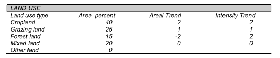
Land use types. The following major land use types, (and subtypes) are recognized:
Cropland: land used for cultivation of crops, including fallow (field crops, orchards)
Grazing land: land used for animal production
Forest land: land used mainly for wood production and other forest products, protection.
Mixed land: mixture of land use types within the same land unit: agroforestry (trees and crops), agro-pastoralism (crops and livestock), agro-silvo-pastoralism (crops, trees and livestock).
Other land: recreation, road sites, construction sites, etc.
Area percentage of the land use type (For each land use type, the relative area should be assessed as a percentage of the total land use area and displayed in a pie chart).
Land use areal trend. The changes in areal extent of the Land Use Type (LUT) can be represented by one of the following five classes:
-2: area coverage is rapidly decreasing in size, i.e. >2 percent per year of that specific LUT area.
-1: area coverage is decreasing in size, i.e. 0-2 percent per year of the LUT area
0: area coverage remains ± stable as a percentage of the LUT area
1: area coverage is increasing in size, i.e. 0-2 percent per year of the LUT area
2: area coverage is rapidly increasing in size, i.e. > 2 percent per year of the LUT area
Land use intensity trends. A change in the intensity of land use is expressed through changes in inputs, management, or number of harvests, etc., over approximately the last 10 years. Only changes within the same LUT and on the same area (change of intensity) are to be considered here - not changes from one LUT to another.
-1: A moderate decrease in land use intensity
-2: A major decrease in land use intensity
0: No major changes in inputs, management level, etc
1: Moderate increase, e.g. switch from no or low external input to some fertilizers/ pesticides; switch from manual labour to animal traction
2: Major increase, e.g. from manual labour to mechanization, from low external inputs to high external inputs, etc.
Example:
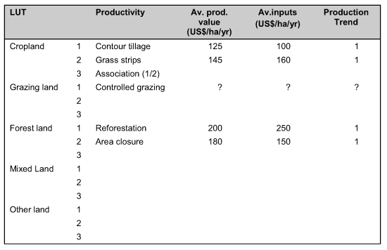
US dollar equivalents for the average production value of outputs per hectare for each land use type will be used as a relative indicator for productivity, and for estimating trends and regional differences. Figures for cropland will generally be easier to give than for other land uses, but if figures were known for grazing land or forest land, they would be welcome.
Average input. The production value for each LUT is related to inputs of materials, equipment and labour per hectare per year. Hence all inputs, including hidden costs such as the farmer's own labour, should be estimated. Any establishment costs should be averaged over the period since implementation and added to the annual costs. The total value of the inputs may be higher than the total production value. Some quite productive areas may actually appear not to be all that profitable in proportion to the amount of inputs, e.g. from analysis of farm budgets. Inputs include labour - own and hired, seeds, fertilizers, pesticides, mechanization/hire of ox, cost of irrigation, income from outside farm, income from livestock.
Productivity trend. Although changes in productivity can be attributed to a wide variety of causes, they may also be an indication of soil degradation or, if positive, of effective soil conservation and appropriate land management. Only a rough indication of trends in productivity is required here:
1: increasing outputs
0: no change in outputs
-1: decreasing outputs
Example:
Agro-ecological zones (definition of AEZ, AEZ map)
Land capability classes (definition of LCC, percent cover)
Water resources:
Surface water, groundwater, nonconventional water resources, fossil resources. Major basins (surface and groundwater); dams, flood control, mobilization of water resources; international rivers, agreements...
Water use by sector and trends: trends in agricultural water withdrawal - irrigation and livestock watering - domestic water withdrawal and industrial water withdrawal, other uses; future: competition between sectors
Wastewater: treatment, reuse (agriculture)
Irrigation potential (method of calculation)
Place of irrigation/drainage in agriculture, percentage of cropland irrigated
History of irrigation in the country, trends
Description of the different irrigation systems
Irrigation methods (spate, flood recession, full control...)
Irrigation techniques: breakdown by technique (sprinkler, surface..); trends in development of drip and sprinkler irrigation; breakdown by source of water (river, groundwater..); wastewater reuse in irrigation
Irrigated schemes: typology by size and by operating modes; scheme size; number of beneficiaries, management, performances, cropping intensity, fees
Cost of irrigation development, cost of O&M, return form irrigation
Irrigated crops: major crops, areas and production, comparison rainfed/irrigated yields for major crops
Institutional environment
Institutions in charge of water resources assessment, development of irrigation; mandates of the main institutions.
Water and land legislation (status, implementation).
Trends in water resources and irrigation development, constraints to development, institutional changes, perspectives.
Use of plant nutrient resources (types of plant nutrients used, trends in plant nutrient use, projections in plant nutrient consumption).
Trends in mineral fertilizer consumption per hectare (Kg/ha) and yields, per main food crop (also rice types) and cash crops
Types of fertilizer produced locally/imported
Cost of different fertilizer products (port handling, transport price, storage price)
Fertilizer subsidies
Farm budgets in different cropping systems
Farmer cash flow
Impact of fertilizer use on the environment. Nutrient imbalance (effects of nutrient imbalance on soil fertility; the application of mixed fertilizer programmes and results)
Natural Hazards (type, location, frequency, damage to food crops, control methods adopted and their effectiveness)
The detail of items will depend upon particular country circumstances
Hot Spots (definition)
Problem soils (definition of problem soils, localization map and area of problem soils)
Human-induced soil degradation (types, extent, localization and effect on crop yield)
Land use issues
Encroachment on prime agricultural land conversion
Land tenure and land policy
Conflicts in land use
Water use issues
Conflicts related to use of water resources
Inadequate use of water resources
Other hot spot issues
Concentration of agrochemicals and pollutants
Genetic erosion and biodiversity depletion (risk areas)
The detail of items will depend upon particular country circumstances
Bright spots (success stories for hotspot items)
Available lands for sustainable agricultural development
Sound land use and allocation policies
Landcare programmes
Success stories in land use
New technologies (biotechnology etc.)
Infrastructures and mechanization/automation (e.g. precision farming)
Sound use of water resources
The challenges are country specific. They have to be clearly identified especially in land, water and plant nutrition resources management, and strategies developed to meet the challenges.
![]()
![]()
![]()