![]()
![]()
![]()
For the purposes of this study, the countries of the world have been grouped into ten regions composed of various subregions (below and Annex 1 for details). Annex 3 presents the regional data in the form of maps (Annex 3 Maps 4-13).
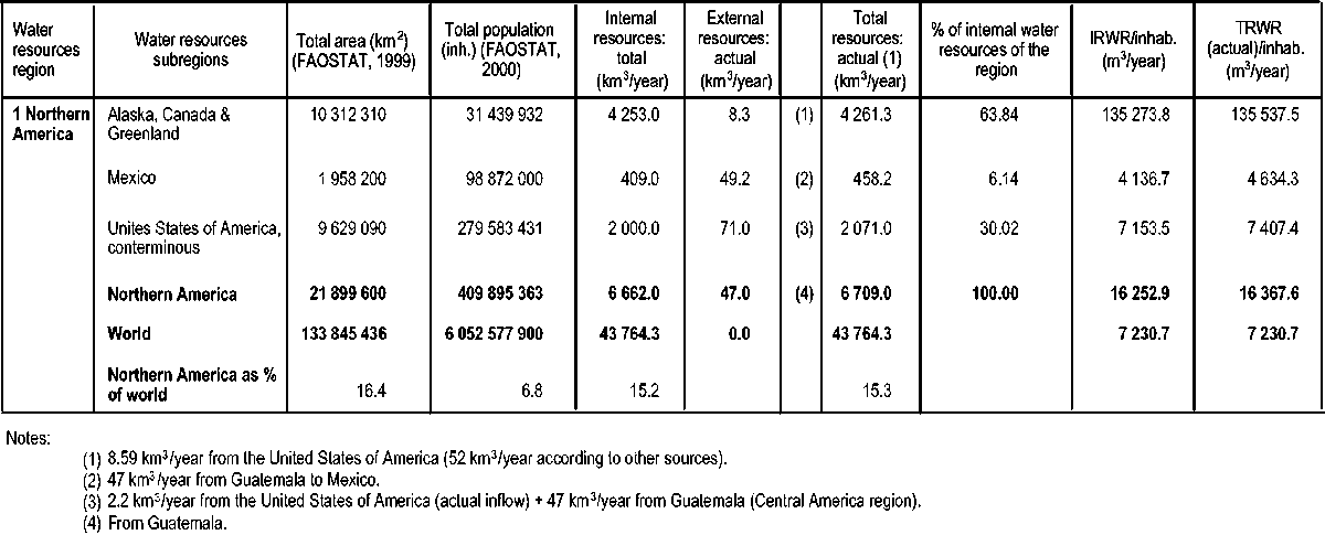
The Northern America region extends over about 21 million km2, which is 16 percent of the world’s land area. It presents a large range of climate and hydrographic situations and can be divided into three subregions:
Alaska, Canada and Greenland: Alaska (United States of America), Canada and Greenland;
Mexico: Mexico;
The United States of America: the United States of America (conterminous states).
The climate of Alaska can be divided into three types: pacific, arctic and continental. The Pacific and southeastern coastal area has relatively mild winters and cool summers. The annual precipitation ranges from 1 524 to 3 810 mm. The arctic region north of the Brooks Range has a colder climate. Annual precipitation is less than 127 mm. The interior continental region has the same climate as the Montana Plains. The natural runoff of Alaska is estimated at 801 540 million m3/year, almost 50 percent of the runoff of the conterminous states of the United States of America.
Canada is the second largest country in the world with a total area of 9 976 180 km2. Freshwater bodies cover 7.6 percent of its area. Most of Canada lies in the zone of the westerly winds, but the predominance of migrating cyclones and anti-cyclones brings variable winds and weather. Precipitation is high along the Pacific coast, and low in the interior and in the arctic and subarctic regions. The annual precipitation decreases in a northerly direction from 500 mm in the central area to 125 mm in the arctic islands. Precipitation increases again towards the east coast, ranging from 900 mm in Ontario to more than 1 482 mm in Newfoundland. Snow contributes 5 percent of the total precipitation in Vancouver and 23 percent in Montreal.
Canada possesses about 9 percent of the world’s freshwater resources. It has four major drainage basins: Atlantic (15 percent), Hudson Bay (38 percent), Arctic (36 percent) and Pacific (10 percent). It also contributes a small part to the flow of the Mississippi-Missouri River. The most important waters draining into the Atlantic Ocean are from the Great Lakes through the Saint Lawrence drainage basin. The Great Lakes store 22 700 km3 of freshwater, 99 percent of which is a remnant from the glacial period and so non-renewable. Canada has more than 31 000 freshwater lakes, ranging from 3 km2 to more than 100 km2.
TABLE 11: Water resources in the Northern America region
Mexico, with an area of 1 958 200 km2, represents 9.2 percent of the region’s total area. It is located in the Intertropical Convergence Zone. However, the altitude and maritime influence generate penetrating masses of humid air deriving from the Gulf of Mexico and Pacific Ocean. These two factors moderate the country’s temperatures. Precipitation is scarce in the north of the country but more abundant in the southeast and in the valleys of the Gulf of Mexico and of the Pacific, south of the Tropic of Cancer. Precipitation occurs mainly from June to October. The country also experiences extreme meteorological phenomena, such as the tropical cyclones that occur between May and November, affecting the coasts of the Pacific and those of the Gulf of Mexico.
The United States of America consists of 50 states for a total area of 9 363 368 km2. A block of 48 contiguous states referred to as the conterminous states forms a belt of 7 828 016 km2 across the continent from the Atlantic Ocean to the Pacific Ocean. This subregion lies more or less within the temperate zone of the northern hemisphere. The other two states are Alaska (1 520 000 km2) and Hawaii (which is included in the Oceania and Pacific region in this study).
Although spanning only 25 degrees of latitude and less than 60 degrees of longitude, the conterminous states have a variety of climates, vegetation and physical features: steep, rugged mountain ranges; subtropical ranges; deserts; frosted areas; frost-free regions; areas with very short summers; lush forests; vast grasslands; and prairies with extreme variability in temperature and rainfall. Taken as a whole, the conterminous states receive an average of about 762 mm of precipitation annually. Distribution is uneven with averages of 450 mm from the Pacific coast to the Rocky Mountains, and 710 mm from the Rocky Mountains to the Mississippi River and the Atlantic coast.
The region’s wide range of climates generates a wide spatial variety of hydrological regimes. As a result, the region presents a very uneven distribution in precipitation, water resources and water use.
Table 11 shows the distribution of water resources among the countries of the region. These average figures hide local water scarcity conditions, and the high variability within the countries.
The methodology used to calculate the water resources of the region varies from country to country and is related to the information needed for water management. In the humid areas, water management has focused on flood control and protection. In the arid areas, hydrological studies have focused more on water resources assessment in order to help satisfy relatively high demand, in part for agriculture.
In general, depending on information availability, the water resources balances were estimated mainly on the basis of surface water flows as measured at hydrometric stations. Overall, the region is relatively well endowed with water resources. For an area representing 16 percent of the world’s total land surface, the region receives 17 percent of its precipitation and generates 15.3 percent of its water resources. As this region is the home to 7 percent of the world’s population, the water resources per person exceed 16 000 m3/year, much higher than the world average.
In such large countries, the significance of national figures is limited and should be completed by subnational data sets.
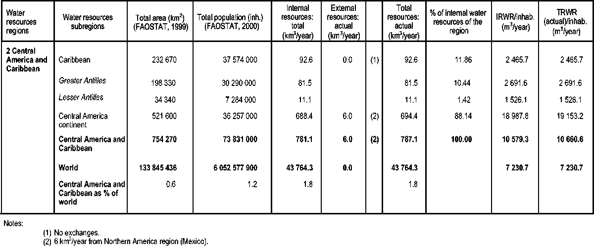
The total area of the Central America and Caribbean region is about 728 000 km2, which is 0.6 percent of the world’s total land area. The region can be divided into the following subregions:
Central America: Belize, Costa Rica, El Salvador, Guatemala, Honduras, Nicaragua, and Panama;
Caribbean: Antigua and Barbuda, Barbados, Cuba, Dominica, Dominican Republic, Grenada, Haiti, Jamaica, Saint Kitts and Nevis, Saint Lucia, Saint Vincent and the Grenadines, and Trinidad and Tobago.
This subregion comprises Belize, Costa Rica, El Salvador, Guatemala, Honduras, Nicaragua and Panama. Its total area is 521 598 km2, or 72 percent of the region. About 80 percent of Central America is mountainous with most of the flat lands located in the coastal areas.
In general, the volcanic range, running through the whole subregion from north to south, serves as the divider between the Pacific and the Atlantic basins. It divides the land asymmetrically, the Pacific coastal flat lands being very narrow with short rivers. The flat lands have been formed from alluvial material from the volcanic ranges.
The climate of Central America is essentially tropical, tempered by its proximity to the sea and by the altitude and local relief characteristics. The Atlantic coast is much more humid than the Pacific coast. Precipitation increases from north to south and from west to east (influenced by the effect that the mountain range exerts on the hot and humid Caribbean currents). The climate has influenced the settlement of the subregion, with most of the population living at altitudes above 1 000 m above sea level (a.s.l).
This subregion consists of two groups of islands: the Greater Antilles and the Lesser Antilles.
Greater Antilles
This group comprises Cuba, Haiti, Jamaica and the Dominican Republic for a total area of 198 330 km2, about 27 percent of the region’s total area. The Greater Antilles are a group of islands located between the Caribbean Sea and the Atlantic Ocean. The largest island is Cuba, followed in terms of area by Hispaniola Island (shared by Haiti and the Dominican Republic).
The Greater Antilles are located in the Intertropical Convergence Zone and are influenced by northern winds. They have a tropical maritime climate, with a dry and a wet season and fairly constant temperatures throughout the year. Temperatures rarely drop below 13 °C.
The population of the Greater Antilles was 30 million inhabitants in 2000 (45 percent of the region’s total population) with an average population density of 147 inhabitants/km2, ranging from 101 inhabitants/km2 in Cuba to 266 inhabitants/km2 in Haiti. The population is predominantly urban (60 percent), with 29 percent of the economically active population engaged in agriculture.
Lesser Antilles
The countries of this subregion are Antigua and Barbuda, Barbados, Dominica, Grenada, Saint Kitts and Nevis, Saint Lucia, Saint Vincent and the Grenadines, and Trinidad and Tobago. This group of islands has a total area of 8 430 km2 (about 1 percent of the region’s total area). Its economy is based mainly on tourism and associated services. Rainfall distribution is determined by the size, shape, topography, relief and geographic position with respect to the north wind. The average annual rainfall in the subregion is 1 141 mm. However, in the mountainous islands there is an important screen effect on the south coasts, characterized by an arid climate. The dry season is more significant towards the south. Tropical storms occasionally cause hurricanes which, after having passed the Greater Antilles, tend to lay waste the Lesser Antilles as far as Trinidad and Tobago.
In this region, highly divided by the relief and islands, the assessment of water resources is often based more on assumptions and extrapolations from climatological data than on hydrometric data measured over long periods.
In this humid region, withdrawal for agriculture and other uses usually represents a negligible percentage of the total water resources. The direct measurements for the estimations of groundwater are scarce and rarely reliable. The indirect method of groundwater assessment through measuring the base flow of rivers is only partially possible in the coastal or insular areas. This is particularly the case for the Greater and Lesser Antilles where groundwater flowing directly to the sea represents a large part of the groundwater resources.
The climate characteristics of the region also generate strong interseasonal and interannual differences in water resources. Meteorological phenomena such as El Niño or tropical storms and hurricanes in the Antilles and Central America alternate with lengthy drought periods. As a consequence, the annual or monthly average estimates of water resources are generally poor indicators of availability.
The region is characterized by a low percentage of water resources shared by several countries (1.7 percent of the region’s total water resources).
Overall, the region is relatively well endowed with water resources, receiving 1.4 percent of the world’s precipitation and generating 1.8 percent of its water resources. With 1.1 percent of the world’s population, the figure for water resources per person in the region can be estimated at about 11 900 m3/year, about double the world average.
TABLE 12: Water resources in the Central America and Caribbean region
Table 12 shows the distribution of water resources among the subregions. These average figures hide the local scarcity conditions that coincide, in general terms, with the most populated areas of the region (along the Pacific coast of Central America).
The figure of 1 000 m3/inhabitant/year is usually used as an indicator of water scarcity. Although data on the water resources distribution within the Lesser Antilles are not available for all countries, this subregion presents the highest water scarcity in the region: Antigua and Barbuda 776 m3/inhabitant/year, Barbados 313 m3/inhabitant/year, and Saint Kitts and Nevis 576 m3/inhabitant/year.
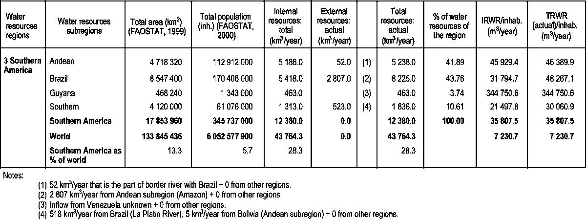
The total area of the region is about 17.8 million km2, which is 13 percent of the world’s total land area. Argentina, Brazil and Mexico together account for almost 65 percent of the region’s total area. The region can be subdivided into the following subregions:
Guyana: Guyana, French Guiana and Suriname;
Andean: Bolivia, Colombia, Ecuador, Peru and Venezuela;
Brazil: Brazil;
Southern: Argentina, Chile, Paraguay and Uruguay.
The Guyana subregion includes Suriname, French Guiana and Guyana, countries that in the south are limited by the so-called Guyana Belt. This mountain range is the border dividing these countries and the Brazilian Amazon River basin.
These countries, with an area of 468 240 km2 (2.1 percent of the region’s total area), are dominated by mountainous tropical and savannah forests. The population density in this subregion is low. Most of the population and the main economic activities are concentrated in the coastal zones. Agriculture is based largely on rice and commercial crops, mainly sugar cane.
The subregion has a tropical climate. The coastal area is characterized by two dry and two wet seasons, while one dry and one wet season characterize the rest of the territory. The coastal average annual temperature varies from 23 to 32 °C. In the interior, away from the moderating effect of the sea, temperature variation is higher, especially between day and night. Precipitation is highest in the south, 1 500-2 400 mm/year, and concentrated mainly in the humid season.
The Andean subregion, with an area of 4 718 320 km2, represents 26.5 percent of the region’s total area and includes Bolivia, Colombia, Ecuador, Peru and Venezuela. The Andes mountain areas cover an important part of the territory and are home to a large population, unlike in Andean areas in Chile and Argentina (included in the Southern subregion).
All the countries in the subregion, except for Bolivia, present three distinct regions: coast, Andes (mountain or sierra), and Amazon forest, each with very different climate characteristics. The coastal area of Peru and an extensive area of Ecuador are warm and dry because of the Humboldt Current and the influence of the Andes mountain range on the warm and humid air mass coming from the Amazon Basin. Precipitation increases towards the north as the effect of the current declines. For example, in the proximity of the Colombian Pacific coast (Choco Forest) precipitation exceeds 9 000 mm/year while on the Peruvian coast it rarely reaches 25 mm/year. The sierra is cold; temperatures vary according to altitude, and the climate is generally dry. In the Amazon forest, precipitation is abundant and its climate is tropical, hot and humid, with constant temperatures throughout the year.
Brazil, with a total area of 8 547 million km2, covers 48 percent of the region and presents a wide diversity in climate. The south of this subregion is moderate, with homogenous precipitation and a uniform climate (with an average annual temperature of 14-18 °C and rainfall of 1 250-2 000 mm/year). In the southeast, the average annual temperature varies from 18 to 24 °C and the rainfall from 900 to 4 400 mm/year; the central-west has an average annual temperature of 22-26 °C and rainfall of 1 250-3 000 mm/year. The northeast has an average annual temperature of 20-28 °C; it includes the semi-arid lands of Brazil with an average annual precipitation, irregularly distributed, of 750 mm to less than 250 mm. The north (with an average annual temperature of 24-26 °C and 1 500-3 000 mm/year of rainfall) covers almost the whole of the Amazon River basin. This area is home to the world’s largest tropical forest, occupying almost half the Brazilian territory. The climate in this subregion is hot and humid.
In the mid-1990s, as a result of government policies on crop diversification during the previous two decades, Brazil was the world’s main coffee and sugar-cane producer, and among the world’s leading producers of coconuts (second), tobacco (fourth) and cotton (sixth). In addition, it has increased steadily its production of grains (wheat, maize, rice and, above all, soybean). With its wide variety of climates, Brazil produces almost all types of fruits, from typical tropical varieties in the north to citrus and table grapes in the moderate zones in the south.
The Southern subregion includes Argentina, Chile, Paraguay and Uruguay. Its total area is 4 121 190 km2 (23.2 percent of the region’s total area). Argentina is the largest country in the subregion, accounting for 59 percent of its total area.
The climate in these countries is varied, essentially because of the differences in latitude (about 20-55 °S) and altitude and because of the presence of the Andes. The temperatures are equally variable, but moderate in most of the four countries; exceptions are the south of Chile, Patagonia and the Andes (climate is cold to arctic), and the north of Chile (which has a desert climate).
The methodology used to calculate the water resources of the region varies from country to country. In general, according to information availability, the water resources balances were estimated mainly on the basis of surface water flows as measured at hydrometric stations. In humid regions, withdrawals for agriculture and other uses usually represent a negligible percentage of the total water resources. This is not the case in arid and semi-arid zones where such withdrawals constitute an important part of TRWR.
In general, the information collected shows that the water resources balances do not take into account groundwater resources and frequently refer to exploitable water resources rather than to annual recharge. Moreover, in some countries, estimated groundwater recharge is based on a global infiltration coefficient applied to average annual precipitation. The validity of such an approach is debatable.
Owing to the non-availability of groundwater data for several countries, estimates were taken from BRGM (1990), assuming that all the groundwater is converted into surface water through base flow. This hypothesis is probably valid in all the humid zones of the region.
The wide range of climates in the region generates a wide spatial variety of hydrological regimes. As a result, the region shows a very uneven distribution in precipitation, water resources and water use conditions. In the humid areas, water management has always focused on flood control and protection. In the arid areas, hydrological studies have focused more on water resources assessment.
As in Central America, the climate characteristics of the Southern America region also generate strong interseasonal and interannual differences in water resources, aggravated by meteorological phenomena such as El Niño.
Moreover, the average total figures for each country do not reflect the local variations in water availability. It would be useful to provide figures by hydrographic basin rather than by country and to evaluate incoming water balance elements in terms of frequency (dry, moderate and humid years) rather than averages. In this way, it would be possible to describe drought situations more completely and identify possible future areas of tension among water user sectors. However, such information is not available systematically.
Overall, the region is relatively well endowed with water resources, receiving 26 percent of the world’s precipitation and generating 28 percent of its water resources. Home to 5.7 percent of the world’s population, the water resources per person in the region are about 35 000 m3/year, well above the world average.
Table 13 shows the distribution of water resources among the subregions. These average figures hide the local scarcity conditions that tend to coincide with the most populated areas of the region. This is the case of Valle Central in Chile, the regions of Cuyo and the South in Argentina, the Peruvian and south Ecuadorian coast, the Cauca and Magdalena valleys in Colombia, the Bolivian Antiplano, the Gran Chaco (shared by Bolivia, Argentina and Paraguay), and northeast Brazil.
In terms of a threshold figure of 1 000 m3/inhabitant/year, none of the countries in the Southern America region are in a situation of water scarcity. However, the figures per country do hide large internal variations. For example, while Chile presents an annual water availability of 63 064 m3/inhabitant, Regions I-V and the Metropolitan Region have less than 1 500 m3/inhabitant, while Regions XI and XII have more than 2 000 000 m3/inhabitant.
The region is characterized by a high percentage of water resources shared by several countries (more than one-third of the region’s total water resources). The computation of water resources is very complex in the case of border rivers such as the Parana River. In some cases, this study observed large inconsistencies between the runoff data of rivers crossing different countries. The Orinoco River in Venezuela has a unique characteristic: at a certain point it divides into two rivers, one flowing to the Atlantic Ocean and one flowing to the Casiquiare River, an affluent of the Negro River (Amazon Basin).
TABLE 13: Water resources in the Southern America region
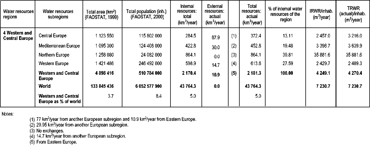
The Western and Central Europe region accounts for about 3.7 percent of the world’s total land area and 8.4 percent of its population. In this study, the Western and Central Europe region is divided into four relatively homogeneous and hydrologically independent subregions:
Northern Europe: Denmark, Finland, Iceland, Norway, Spitsbergen (Norway) and Sweden;
Western Europe: Austria, Belgium, France, Germany, Ireland, Luxembourg, the Netherlands, Switzerland and the United Kingdom;
Central Europe: Bosnia and Herzegovina, Bulgaria, Croatia, Czech Republic, Hungary, Poland, Romania, Slovakia, Slovenia and Yugoslavia;
Mediterranean Europe: Albania, Cyprus, Former Yugoslav Republic of Macedonia, Greece, Italy, Malta, Portugal and Spain.
The Western and Central Europe region includes all of Europe with the exception of Turkey and the countries of the former Soviet Union. The region has diverse climate conditions that affect the patterns of water resources. This variety of climate conditions is due to:
the configuration of Western and Central Europe, a peninsula of the Eurasian continent rather than a continent;
a large range of latitude (35-72 °N);
its large opening to the maritime influence and the development of its coasts over the Arctic Ocean, the Atlantic Ocean, the Mediterranean Sea and the Black Sea.
Overall, water resources are abundant at about 2 200 km3 in an average year (5 percent of the world’s water resources) and 4 270.4 m3/inhabitant/year. However, water resources are unevenly distributed between countries.
Apart from the extreme north (Iceland, northern Sweden and Finland) which has a subarctic climate (cold and relatively dry), the Western and Central Europe region has two types of climates:
temperate oceanic, with rainfall throughout the year, with a transition to a more continental climate with wider contrasts in temperature and rainfall, and with more marked seasons in central Europe, at altitude (the Alps) and in northern Europe.
Mediterranean, with dry summers and rainfall in autumn and spring, prevailing in all the southern part of the region.
Therefore, with the triple influences of latitude, topography and distance from the sea, the distribution of precipitation in the region is very diverse, ranging from less than 300 mm/year in many Mediterranean plains to more than 3 000 mm/year on the coast of the Norwegian Sea or in some areas of the Balkans.
The wetter regions are along the Atlantic shores from Spain to Norway, the Alps and their eastern extension. The regions with less rainfall are the Mediterranean plains in Spain and the plains of central Europe (Hungary and Poland).
TABLE 14: Water resources in the Western and Central Europe region
The development of large river basins has not been possible in such a complex environment, where the distance between mountains and coasts is always short. There are seven main watersheds of more than 100 000 km2. The major one is the Danube Basin (about 800 000 km2), which covers about 17 percent of the region; the second largest is the Rhine Basin, which covers about 5 percent of the region.
The geology of the region is also complex, featuring a mix of ancient mountains, plains and sedimentary basins. This has resulted in numerous small to medium aquifers, most of which discharge into the river network. The rivers drain most of the groundwater, although the karstic coastal aquifers in the Mediterranean area usually flow directly into the sea. The surface water and groundwater are interdependent. Hence, the overlap between them is generally high.
As a direct consequence of the climate and topographic diversity, the runoff regimes of the European rivers are very diverse. On average, river runoff is about 450 mm/year, varying from less than 50 mm/year in areas such as southern Spain to more than 1 500 mm/year in various areas of the Atlantic coast and of the Alps. The Danube River has the largest flow, 205 km3/year, but this is less than 10 percent of the total runoff of the region’s rivers. The next most important rivers in terms of runoff are, in descending order: the Rhine, Rhone, Po, Vistula and Garonne. These rivers have a combined runoff of 265 km3/year, about 12 percent of the region’s total. The region’s rivers are characterized by a wide variety in their flow regimes and in the interannual and seasonal variations in their runoff:
the glacial regime, with base flow in winter and a high runoff coefficient, in Scandinavia and the Alps;
the oceanic regime, with moderated variability, more or less regulated by the groundwater, in Western Europe;
the continental regime, with important runoff deficits and large differences between high and low flow, in Central Europe;
the Mediterranean regime, with a high interseasonal and interannual variability in runoff, in southern Europe.
Table 14 shows the distribution of water resources among the subregions.
Many water resources systems are shared by two or more countries in the Western and Central Europe region. These shared systems represent 22 percent of the region’s water resources. This situation is due in large part to the large number of relatively small countries. The Danube Basin drains 13 countries. The Rhine Basin is shared by seven countries. Most of the major rivers are transboundary or serve as border rivers (the Danube, Rhine, Rhone, Meuse, Oder, Drave, Tagus, Douro, Guadiana, Evros, Escault, etc.).
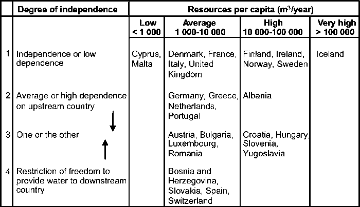
A number of countries are very dependent on their neighbours for water: Croatia, Hungary, Luxembourg, the Netherlands, Portugal, Romania, Slovakia, Slovenia and Yugoslavia. The same countries are often providers of most of the resources of their neighbours (the case with all the landlocked countries): Austria, Bosnia and Herzegovina, Bulgaria, Croatia, Czech Republic, Former Yugoslav Republic of Macedonia, Hungary, Slovakia, Slovenia, Switzerland and Yugoslavia.
The distribution of the European population on the territory is not linked to the geography of water resources. The urbanization level is generally very high. In 2000, renewable water resources per inhabitant ranged from less than 40 m3/year in Malta and 992 m3/year in Cyprus to 1 140 m3/year in Denmark, 85 500 m3/year in Norway and more than 600 000 m3/inhabitant in Iceland. Therefore, the average value for the region of 4 342 m3/inhabitant/year is hardly meaningful, especially as only a small part of these natural resources is exploitable in some places. Some countries rely heavily on external water resources and would fall under the threshold of 1 000 m3/inhabitant/year if they had to rely only on their internal resources: Hungary (less than 600 m3/inhabitant/year), and the Netherlands (less than 700 m3/inhabitant/year).
The Northern Europe subregion has very abundant water resources per country and per inhabitant (except Denmark) and its drainage systems are quite large.
The Western Europe subregion has relatively small rivers. The subregion has large international river basins (Rhine, Meuse, Rhone, Elbe, etc.) and related transboundary pollution problems. In view of the relatively low rate of water abstraction for agriculture in the Western Europe subregion, water allocation problems between the countries there are relatively minor.
The Central Europe subregion is the most populated subregion, with several landlocked countries and low rainfall rates. Water resources per inhabitant are less evenly distributed than in the Western Europe subregion. They are organized around a major watershed (Danube) and some secondary watersheds flowing to the Baltic Sea (Oder and Vistula), the North Sea (Elbe) and the Mediterranean Sea (Drin, Maritza and Vardar). Most of the rivers concerned are transboundary.
The Mediterranean Europe subregion has a higher level of water resources per inhabitant than the Western Europe and Central Europe subregions do. However, the water resources are more irregular, divided in numerous small basins, and unevenly distributed among and within countries. The subregion includes two island states: Cyprus and Malta. Pressure on water is relatively high in the subregion, in part due to the need for irrigated agriculture.
Table 15 summarizes the water situation of the countries of the region in terms of water resources per inhabitant and dependency ratio.
TABLE 15: Classification of Western and Central Europe countries by water resources
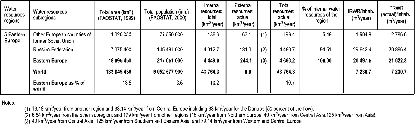
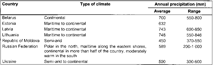
The Eastern Europe region includes the Russian Federation and the eastern European and Baltic states. The total area of the region is about 18 million km2, covering 13.5 percent of the world’s land area of the world and accounting for 3.6 percent of its population. The countries of this region have been grouped in two subregions, based primarily on geographic conditions and, as far as possible, on hydroclimatic homogeneity (although the Russian Federation is subject to a wide variation of geographic and hydroclimatic conditions). The two subregions are:
Russian Federation: Russian Federation;
Other European countries of the former Soviet Union: Belarus, Estonia, Latvia, Lithuania, Republic of Moldova, and Ukraine.
Table 16 summarizes the main climate features of the countries of the Eastern Europe region. It highlights the great variability both between and within countries, from polar to tropical humid. The water resources reflect this climate variability.
In terms of annual IRWR per inhabitant, the Eastern Europe region is characterized by an extreme variability: from a minimum of 227 m3 in the Republic of Moldova to more than 29 000 m3 in the Russian Federation. However, the water resources in the Russian Federation are very unevenly distributed in relation to the population. In the more densely populated western part, annual renewable surface water resources are estimated at about 2 000 m3/inhabitant compared with up to 190 000 m3/inhabitant in the Siberian and Far Eastern regions.
TABLE 17: Water resources in the Eastern Europe region
TABLE 16: Main climate features of the countries of the Eastern Europe region
The Republic of Moldova is the only country with annual IRWR of less than 1 000 m3/inhabitant. However, when adding the external flow to the IRWR, all the countries of the Eastern Europe region show total actual renewable water resources in excess of 2 000 m3/inhabitant. Three countries depend on other countries for more than 50 percent for their renewable water resources: the Republic of Moldova for more than 91 percent of its water resources, Ukraine for 62 percent, and Latvia for 53 percent. All other countries in the region have more than 2 000 m3/inhabitant/year of IRWR and four countries have more than 10 000 m3/inhabitant/year.
Table 17 summarizes the distribution of the IRWR among the two subregions and compares the results with their population. The group of former Soviet Union countries has the highest population density and 1 904 m3/inhabitant/year of IRWR, while the Russian Federation has the lowest population density and more than 29 000 m3/inhabitant/year.
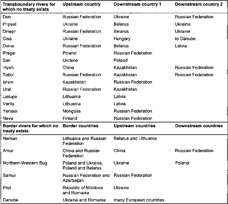
Although the region as a whole is well endowed in terms of water resources related to the population (more than 21 000 m3/inhabitant/year), their distribution varies from 232.8 m3/year/inhabitant for the Republic of Moldova to 30 000 m3/inhabitant/year for the Far Eastern part of the Russian Federation. In the areas with low IRWR, the network of rivers partly offsets these handicaps and brings the total water resources per inhabitant to an acceptable level. Water resources are distributed among the countries of the region and surrounding countries through an extensive surface water network crossing borders, and occasionally acting as borders between countries. At the time of the Soviet Union, interregional water management was governed through master plans. Since 1990, no specific treaty has been enacted between countries in order to fix the shares of each riparian country in a river system (except in some riparian countries in the Near East region). Table 18 shows the diversity of situations now prevailing in the region.
Africa is a large continent of 53 countries with a wide range of hydrological situations. Indeed, such is the region’s diversity, it could be divided into 24 major hydrological units or basin groups: 8 major river basins, draining to the sea (Senegal, Niger, Nile, Shebelli-Juba, Congo, Zambezi, Limpopo and Orange rivers); 9 coastal regions grouping several small rivers, also draining to the sea; 5 regions grouping several endorheic drainage basins (Lake Chad, Rift Valley, Okavango, South Interior and North Interior).
TABLE 18: Transboundary and border rivers in the Eastern Europe region
For the purposes of this study, the Africa region was divided into seven climate subregions on the basis of geography and climate:
Northern Africa: Algeria, Egypt, Libyan Arab Jamahiriya, Morocco and Tunisia;
Sudano-Sahelian: Burkina Faso, Cape Verde, Chad, Djibouti, Eritrea, Gambia, Mali, Mauritania, Niger, Senegal, Somalia and Sudan;
Gulf of Guinea: Benin, Côte d’Ivoire, Ghana, Guinea, Guinea-Bissau, Liberia, Nigeria, Sierra Leone and Togo;
Central Africa: Angola, Cameroon, Central African Republic, Congo, Democratic Republic of Congo, Equatorial Guinea, Gabon and Sao Tome and Principe;
Eastern Africa: Burundi, Ethiopia, Kenya, Rwanda, Tanzania and Uganda;
Indian Ocean Islands: Comoros, Madagascar, Mauritius and Seychelles;
Southern Africa: Botswana, Lesotho, Malawi, Mozambique, Namibia, South Africa, Swaziland, Zambia and Zimbabwe.
The information available is uneven and very poor for some of the African countries. Many studies were carried out in the late 1980s and in the 1990s on water resources in African countries, mainly in water scarce areas. In humid countries, little attention is given to the subject and information is rare.
With the exception of the Indian Ocean Islands, all the subregions are between 2 and 9 million km2 in area, the smallest being the Gulf of Guinea subregion and the largest being the Sudano-Sahelian subregion. A quantitative estimate of the average annual rainfall was available from national sources for 41 out of 53 countries. These data were compared with the recently available digital map of rainfall in Africa. In an attempt to improve the homogeneity of rainfall information, the results from the digital maps were selected, except for the islands (for which no digital map was available). Each subregion has its climate specificity.
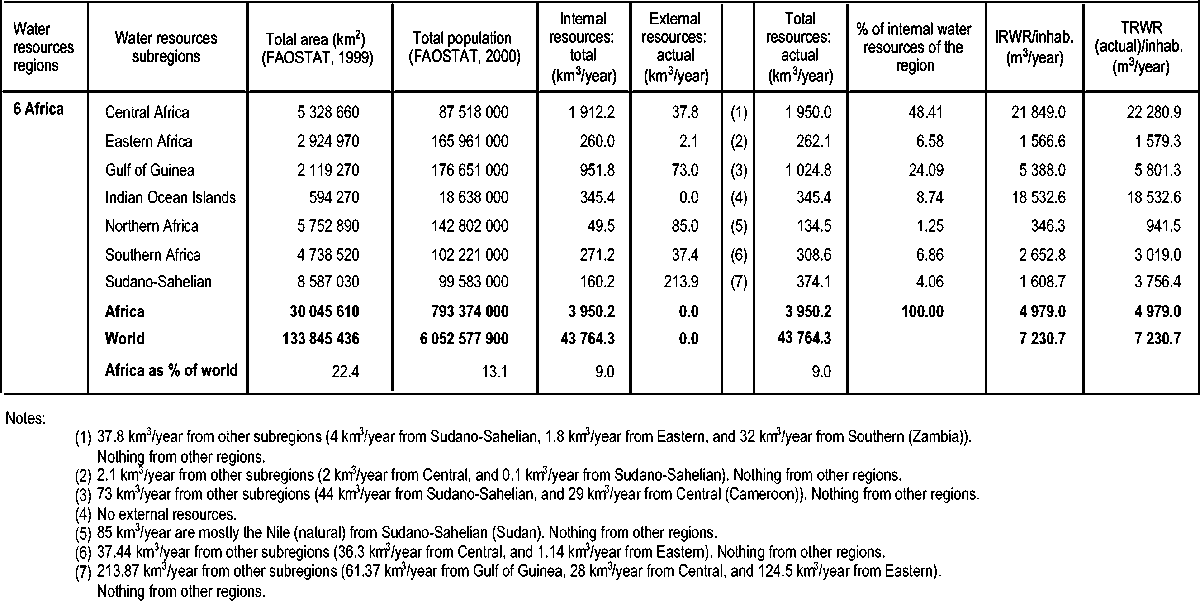
Table 19 compares the values for internally produced water resources (including surface water and groundwater) and total renewable resources with precipitation and population for the seven Africa subregions.
This subregion extends from the Mediterranean climate zone to the desert. It has two rainy seasons in autumn and spring, with a clear, dry summer season. There are major differences within the subregion between the Maghreb (Algeria, Libyan Arab Jamahiriya, Morocco and Tunisia) and Egypt. The Maghreb has climates changing from north to south, a divided and dispersed hydrography (some average-sized rivers only in Morocco), and an important endorheic zone (especially in the Sahara). It has scarce resources but very few transboundary exchanges. Egypt has an arid climate and a simplified hydrography with only one river, the Nile River flowing from the highlands of Ethiopia, Rwanda and Burundi. It has very reduced internal resources.
Northern Africa has very limited water resources, with less than 10 mm/year on average and it is in a situation of very severe water scarcity, with values per inhabitant varying between 200 and 700 m3/year. In terms of internal water resources, it is the poorest subregion in Africa (1.2 percent of the continent’s total internal water resources) and it is the subregion with the highest percentage of external water resources (63 percent) due to the Nile River, which serves only one country.
However, the Sahara has very important fossil groundwater reserves of major sedimentary aquifers such as the Continental Sahara, Murzuk, and the Nubian Basin. These resources are common to various countries.
The subregion is marked by a climate zoning from north to south, from arid to tropical climates. The hydrographic system is not dense but structured around major transboundary river basins such as the Nile and the Niger, flowing across subregions. The subregion is also characterized by important endorheism, structural as in the case of Lake Chad, or functional as in the case of the large inner deltas of the Niger and Nile rivers, resulting in important evaporation and reduction in runoff. The groundwater flows are important and there are significant exchanges between surface water and groundwater. The runoff regimes are irregular.
Overall, the water resources are limited and very unequally distributed across the subregion. The subregion receives 57 percent of its resources from outside, mostly from the Fouta Djalon in Guinea, considered the water tower of western Africa (source of the Gambia, Senegal, Niger and Chari rivers) and from the highlands of eastern Africa (Nile, Shebelli and Juba rivers from Ethiopia). It is the second poorest subregion in Africa in terms of water (less than 5 percent of the continent’s internal water resources). Like Northern Africa, this subregion has a high potential of fossil groundwater reserves (the Senegal-Mauritania Basin, the Lullemeden Basin in Niger, and the Chad Basin) but they have not been estimated properly and they are difficult to access in some cases.
TABLE 19: Water resources in the Africa region
The subregion benefits from a monsoon-type, tropical humid climate. The hydrographic system is dense but divided in many small systems. Its main river basin is the Niger (Africa’s second river by average flow), shared between ten countries. The subregion’s internal resources represent 25 percent of the continent’s total water resources. Groundwater represents one-third to one-half of the subregion’s total water resources, with important overlap between surface water and groundwater systems.
This subregion has a humid equatorial climate in the south with long rainy seasons. A dense and concentrated hydrographic networks feeds two major rivers: the Congo River (the world’s second largest river after the Amazon River) and the Ogooué River (Africa’s third largest river).
Water resources are abundant and represent 48.4 percent of the continent’s internal resources. The groundwater component is important but the overlap with surface waters is high. This subregion is a major provider of water to neighbouring subregions.
This subregion is characterized by diversified climate conditions (tropical humid to semi-arid) and two rainy seasons: autumn and spring. The hydrographic network is not dense and there is no major river except the Nile River in Ethiopia. However, the subregion is home to Africa’s largest lake (Lake Victoria).
The water resources are limited (6.5 percent of the continent’s internal resources) and the subregion does not receive much water from outside. Groundwater resources are important and there is a high overlap with surface runoff. This subregion provides water to the Sudano-Sahelian subregion through the Nile River.
This subregion encompasses very diverse situations. It includes: (i) Madagascar, a large island with a climate varying from tropical humid in the north to semi-arid in the south; and (ii) various archipelagos of small islands in a tropical humid climate zone.
This subregion ranks third in terms of water resources. Madagascar is the continent’s second richest country in terms of water after the Democratic Republic of Congo. The groundwater contribution is low but with a high overlap. The other small islands have abundant water resources, but these are mainly groundwater and scattered within their territories.
This subregion has a very diverse climate, from subtropical humid to arid. It has various major river basins, all transboundary: Zambezi, Limpopo and Orange. The Okavango Basin in Botswana is endorheic.
The water resources are modest (7 percent of the continent’s total), mainly internal to the subregion, and very unequally distributed within it. Important external resources enter from the Central Africa subregion (mostly through the Zambezi Basin). Important groundwater reserves can be accessed but are in part not renewable, especially in South Africa.
The Africa region represents an important part of the world in terms of land and water: 22.4 percent of the world’s land area, and 9 percent of the world’s actual water. With only 13 percent of the world’s population, Africa has reasonable resources with 4 979 m³/inhabitant/year at the continent level. However, although they cover the largest part of the continent, the Northern Africa and Sudano-Sahelian subregions contribute only 1.2 and 4.06 percent respectively of the Africa region’s total water resources. The Southern Africa subregion also has a very low runoff coefficient (9 percent).
In addition, the Africa region shows very diverse hydrographic conditions:
The size of the drainage water systems varies greatly from country to country. The Congo River basin represents 30 percent of the continent’s runoff. Together, the continent’s ten major rivers provide 50 percent of its total runoff.
The endorheic basins represent one-third of the continent’s area.
The possibilities for developing water infrastructures, in particular dams, are limited. Moreover, such infrastructures are often subject to high silting rates, in particular in the arid and semi-arid regions. In the Maghreb, the useful life of a dam is often less than 50 years (Margat/OSS, 2001). In Sudan, the Khams el Girba Reservoir lost 40 percent of its theoretical useful capacity (1 300 million m3) between 1965 and 1977, with an average sedimentation rate of 80 million tonnes/year.
Groundwater recharge is a critical factor for the development of arid and semi-arid countries. The distribution between surface water and groundwater illustrates the difference between arid and humid subregions. In arid subregions (Northern Africa, Sudano-Sahelian and Southern Africa), groundwater recharge is important and a large part of groundwater resources is not connected to the river system. The base flow of the rivers is usually low, and the overlap between surface water and groundwater is small. On the other hand, in humid subregions (Gulf of Guinea and Central Africa), aquifers are connected to the river system and groundwater constitutes almost the entire base flow of rivers. Thus, overlap is almost equal to the groundwater resources.
In arid regions, evaporation from wetlands and lakes plays a major role and may substantially limit the amount of water resources available for use. In Sudan, Mali and Botswana, the quantity of water leaving the country is less than the quantity of the water flowing into the country. The river flows in these countries decrease progressively, mainly as a result of the high rates of evaporation in internal deltas. This is the case with the Nile River, the Niger River, the Okavango River, and the semi-endorheic Saharian watercourses. The present study reviewed the water balance of these major water bodies carefully. In some cases, water resources were calculated upstream of the major evaporative areas (Mali, Uganda and Egypt). For Sudan, water resources were computed taking into account evaporative losses in the wetlands of the Sudd.
The water scarcity that prevails in the arid countries has forced national economies to find alternative ways to satisfy the demand for freshwater. Some countries convert an increasing amount of water from poor quality aquifers (brackish water) into usable water. Similarly, treatment and reuse of wastewater is a common practice in countries in the Northern Africa subregion. Information on reused treated wastewater exists for most of the countries but there is probably a large amount of non-treated wastewater which is reused for agriculture around the main cities and which is not reported.
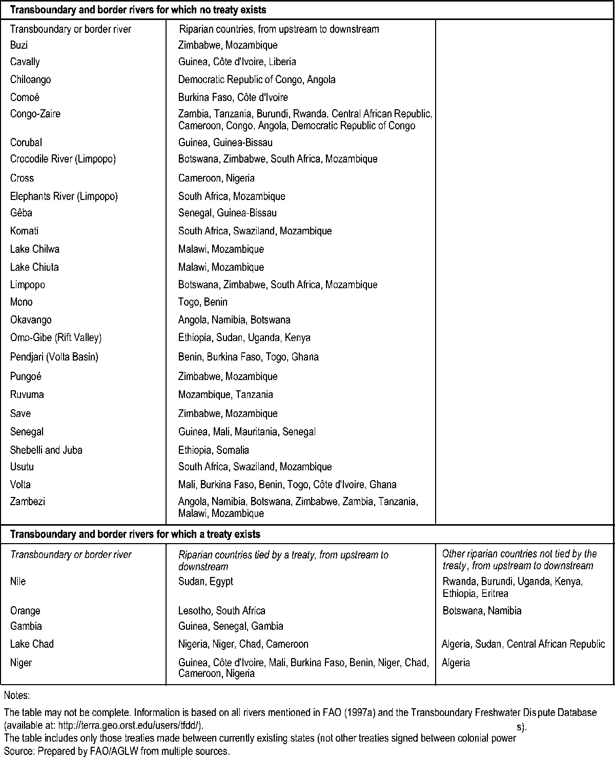
Africa has large rivers crossing several climate regions. These play a major role in the water exchanges in the subregions. The Nile, Niger, Chari, Senegal, Okavango and Orange rivers all contribute to important transfers of water from wet to dry regions (Table 20). The countries of the Sahel in western Africa receive about 50 km3/year from their southern neighbours. Considering the Africa region as a whole, these transfers of water from humid to arid zones represent 50 percent of the water resources of the arid zones.
Another specificity of the Africa region is the non-renewable groundwater reserves located in the large sedimentary aquifers systems (Continental aquifer, Nubian sandstones, Sahel and Chad watersheds, Kalahari, etc.). These systems represent an important resource for the arid zones in view of the limited availability of renewable water resources. They are particularly important for Saharan countries such as Algeria, Egypt, Libyan Arab Jamahiriya, Niger and Tunisia. In these systems, the reserves considered exploitable can amount to many thousand million cubic metres. The Libyan Arab Jamahiriya depends heavily on fossil groundwater to cover its current water demand.
For the purposes of this study, the Near East region was divided into three subregions with some common characteristics:
Arabian Peninsula: Bahrain, Kuwait, Oman, Qatar, Saudi Arabia, United Arab Emirates, and Yemen;
Caucasus: Armenia, Azerbaijan and Georgia;
Middle East: Gaza Strip (Palestinian Authority), Iraq, Islamic Republic of Iran, Israel, Jordan, Lebanon, Syrian Arab Republic, Turkey, and West Bank (Palestinian Authority).
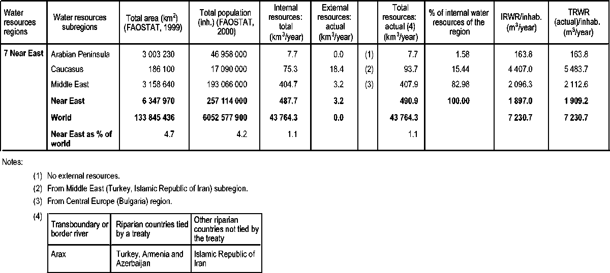
The Near East region as considered here represents an area of 6.34 million km2 and includes 250 million people.
The common feature of climates in the region is that they are dry. These dry climates create major irrigation needs. However, there is a sharp contrast between countries with temperate regions to provide them with abundant water resources (e.g. Turkey) and countries adjacent to dry and desert areas with very limited water resources.
TABLE 20: Transboundary and border rivers in the Africa region
The Near East is the region of the globe with the lowest figures in terms of absolute and per inhabitant water resources, even when considering the contribution of rivers flowing in from more humid regions of Anatolia (the Euphrates River) and the Caucasus.
Precipitation in the region is very low and variable, and the region’s water resources are particularly sensitive to drought. During dry years, which occur approximately every ten years, rainfall can be as low as one-third of its long-term average. Typically, the development of surface water resources requires the construction of increasingly expensive flow-regulation systems (dams), with environmental impacts that threaten their long-term sustainability.
While the Near East region covers 4.7 percent of the world’s total land area and contains 4.25 percent of its population, the region’s water resources are only about 1.1 percent of the world’s TRWR. The countries of the Near East region have less water resources per person than the world average. The TRWR per inhabitant are less than 1 000 m3/inhabitant in 10 out of 18 countries. When considering only the IRWR, the number of countries under stress is higher. Large differences exist also between the subregions. The Arabian Peninsula has very limited water resources, with less than 10 mm/year of rainfall on average, and is in a situation of very severe water scarcity, with values between 200 and 700 m3/inhabitant/year. In contrast, the Middle East subregion shows much higher values, due mostly to the abundant flows generated in the mountainous areas of Turkey and of the Caucasus subregion.
Furthermore, the water resources distribution within the region is far from uniform (Table 21). Topography, distance from the sea, latitude and resulting hydroclimatic conditions, the diversity of the hydrographic networks and of the geological structures, and transboundary rivers are all factors that give rise to extremely contrasting water situations.
The water scarcity that prevails in the region has forced and will continue to force national economies to find alternative ways to satisfy the demand for freshwater.
Some oil-rich countries convert a significant amount of saline water from the sea or from poor-quality aquifers (brackish water) into drinking-water. The total use of desalinated water in the Near East region is estimated to be 3.93 km3/year (Gleick, 2000). In absolute terms, three countries (Saudi Arabia, the United Arab Emirates, and Kuwait) are by far the largest users of desalinated water, accounting for 77 percent of the total for the region (Saudi Arabia alone accounts for 47 percent).
Similarly, wastewater treatment and reuse is becoming a common practice in the Near East region. Figures for produced and treated wastewater are available for some countries but may be underestimates. In most countries, there are few wastewater treatment plants. Information on reused treated wastewater exists for most of the countries but is probably not reliable.
In terms of their water resources, the three subregions of the Near East region are rather independent of one another and there is practically no exchange of water between them. The Near East countries can be classified in three categories:
1. Countries relying mostly on significant internal resources: the Islamic Republic of Iran, Lebanon and the countries characterized by high IRWR due to their favourable geographic situation (Turkey and the Caucasian countries). This group is characterized by a dependency ratio of less than 50 percent and IRWR in excess of 1 000 m3/inhabitant/year. Some of these countries contribute heavily to the provision of water to downstream countries (Lebanon, Turkey and the Islamic Republic of Iran) through the river systems.
2. Countries with a significant part of their resources of external origin: Iraq and the Syrian Arab Republic. This group may be identified by a dependency ratio of more than 50 percent. Iraq has IRWR in excess of 1 000 m3/inhabitant/year. In this category, the major problem in assessing water resources lies in estimating the transboundary surface water and groundwater flows. These countries are also characterized by significant differences between natural and actual resources. In this study, special attention was given to the estimation of the actual flows, based on the information available.
3. Countries with very limited renewable internal and external water resources such as Israel and Jordan. This group is characterized by IRWR of less than 1 000 m3/inhabitant/year and a dependency ratio of less than 50 percent. These countries face a critical situation in terms of water resources. Depending on their geographical position and their geological characteristics, they have adopted different approaches to meet their internal water demand. Some of them (Jordan, Saudi Arabia and Bahrain) have substantial non-renewable groundwater resources, partly shared with neighbouring countries and for which each country adopts different mining policies. The remaining countries do not have other significant groundwater reserves at their disposal either because of their size (Qatar and the United Arab Emirates) or because of the geology of the country.
TABLE 21: Water resources in the Near East region
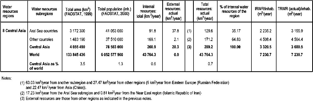
TABLE 22: Climate variability in the Central Asia region.
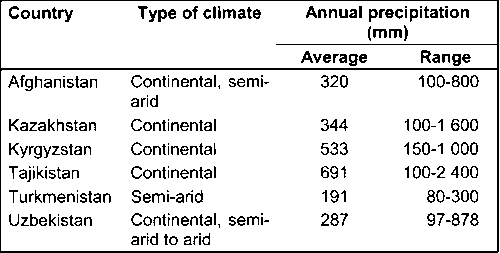
The main features of the climate of countries in the Central Asia region are a great variability from country to country and within countries (table 22). The same applies to water resources. The region can be divided into two subregions:
Aral Sea countries: Kazakhstan and Uzbekistan;
Other countries: Afghanistan, Kyrgyzstan, Tajikistan and Turkmenistan.
Although the Central Asia region covers 3.5 percent of the world’s total land area and contains 1.3 percent of its population, its water resources are only about 0.7 percent of the world’s TRWR. However, the region is reasonably endowed with water (3 320.5 m3/inhabitant/year). The figures in the column external resources in Table 23 correspond to either actual inflow affected by upstream consumption or to inflow secured through treaties. Therefore, the actual inflow may be higher than the inflow secured through treaties indicated in the table for certain countries (e.g. Uzbekistan). Another difficulty related to the inflows or outflows secured by treaties relates to the fact that in most cases the treaties fix the exchanges between countries in terms of percentage of basin water resources, which vary from year to year.
This is the case with the countries around the Aral Sea. The inflows indicated here are somewhat theoretical as they have been calculated on the basis of an estimate of the average annual water resources for the whole Aral Sea Basin (Amu Darya and Syr Darya) and of water allocation defined as a percentage of part (65-70 percent) of the total basin water resources, according to the master plans for water resources development in the Amu Darya (1987) and Syr Darya (1984) basins, endorsed by the Interstate Agreement of 18 February 1992.
For the flows that are not subject to formal treaties or agreements, the values indicated in Table 23 correspond to average annual actual flows in recent years. However, owing to difficulties in collecting reliable data, the flow average was not calculated systematically over the same period.
TABLE 23: Water resources in the Central Asia region
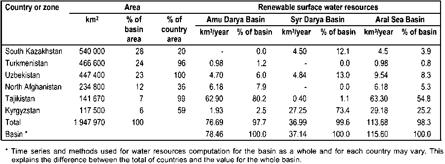
The Aral Sea, located in a depression in the Turan Plain, is fed by two major rivers: the Amu Darya in the south, and the Syr Darya in the north. These rivers originate in the southwestern Pamir and Tien Shan mountain ranges respectively. The combined basin of these two rivers has a total area of about 1.9 million km2 and spreads over six countries. In Kazakhstan, all the flow of the Turgay, Sarysu, Chu and Talas rivers is lost in the desert or is directed to natural depressions. It can be considered that these rivers are not part of the Aral Sea Basin sensu stricto.
The assessment of natural flow in the basin is hampered by the large amounts of water withdrawn from the rivers since the 1950s for irrigation purposes. Reconstructing long-term time series, the average annual renewable surface water resources in the Aral Sea Basin are estimated at 116 km3, of which 78 km3 in the Amu Darya Basin and 37 km3 in the Syr Darya Basin (Table 24). For a 20-year return period, the values are 47 km3 for the Amu Darya and 21 km3 for the Syr Darya.
Before 1960, the level of the Aral Sea was more or less stable. Its surface area was about 66 000 km2 and its volume about 1 060 km3. The Aral Sea received water from the following sources: surface water (the total average discharge of the Amu Darya and Syr Darya to the Aral Sea was about 47-50 km3/year), groundwater inflow (5-6 km3/year), and precipitation over the Aral Sea (5.5-6.5 km3/year). The total volume of 57.5-62.5 km3/year compensated the evaporation from the lake, estimated at about 60 km3/year. The level of the Aral Sea was then fluctuating about 50-53 m above the average level of the oceans. The difference between the renewable surface water resources of the Aral Sea Basin, estimated at 115.6 km3/year, and the necessary discharge to the Aral Sea for a stable water balance, estimated at 47-50 km3/year, could have been available for use in the basin, i.e. about 65.6-68.6 km3/year. The average mineral content of the seawater was estimated at 10 g/litre in 1960.
TABLE 24: Renewable surface water resources of the Aral Sea Basin
In the 1960s, the development of irrigation in the Soviet part of the Aral Sea Basin increased the irrigated area from about 4.5 million ha in 1960 to almost 7 million ha in 1980. The population rose from 14 million inhabitants in 1960 to about 27 million inhabitants in 1980. Total water withdrawal increased from 64.7 km3 in 1960 to 120 km3 in 1980, of which more than 90 percent for agricultural purposes, and resulted in the disruption of the prevailing water balance in the basin. Today, the inflow to the Aral Sea is estimated at 1-2 km3/year from the Syr Darya and 5-10 km3/year from the Amu Darya.
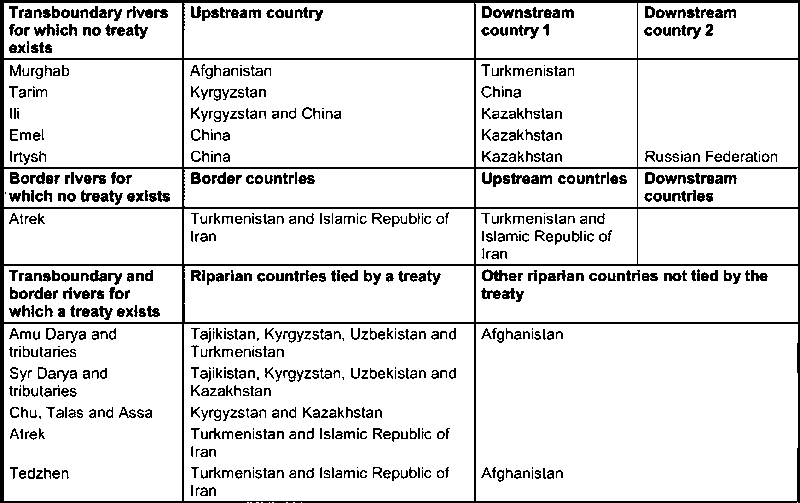
TABLE 25: Transboundary and border rivers in the Central Asia region
Water resources are distributed among the countries of the Central Asia region and surrounding countries through an extensive network of rivers either crossing borders or acting as borders between countries. At the time of the Soviet Union, water management was governed through master plans. After the ending of the Soviet Union, treaties had to be enacted in order to allocate water to the various riparian countries.
Table 25 shows the diversity of the situations now prevailing in the Central Asia region in terms of water exchanges.
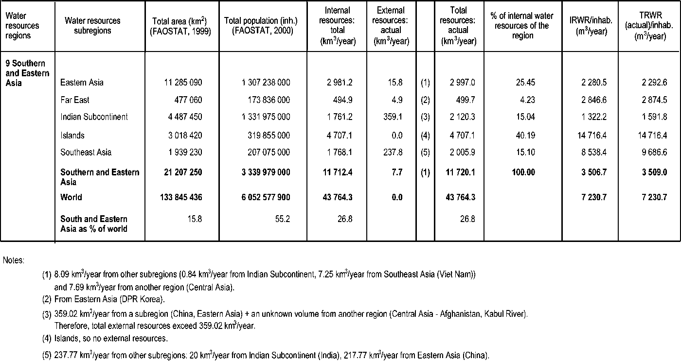
The total area of the Southern and Eastern Asia region is about 20.4 million km2, which is 15 percent of the world’s total land area. China and India together account for about 63 percent of this area. The region can be divided into five subregions as follows:
Indian Subcontinent: Bangladesh, Bhutan, India, Maldives, Nepal, Pakistan and Sri Lanka;
Eastern Asia: China, Democratic People’s Republic of Korea, and Mongolia;
Far East: Japan and Republic of Korea;
Southeast Asia: Cambodia, Lao PDR, Myanmar, Thailand and Viet Nam;
Islands: Brunei, Indonesia, Malaysia, Papua New Guinea and Philippines.
The Indian Subcontinent subregion extends over an area of 3 961 680 km2, about 18 percent of the region’s total area. It comprises Bangladesh, Bhutan, India, Nepal, Maldives, Pakistan and Sri Lanka. The geomorphology of these countries consists of a large portion of floodplains along the Indus and Ganges river basins, some terraces and hilly areas, and the mountainous terrain of the Himalayas, with the world’s highest peak (Mount Everest, 8 848 m a.s.l.) located in the Nepal Himalayas.
The subregion experiences a tropical monsoon climate, with significant seasonal variations in rainfall and temperature. About 80 percent of the total precipitation occurs during the monsoon period. The climate year includes two monsoon periods: the southwest monsoon (June-September), which brings most of the rainfall; and the northeast monsoon (November-March), relatively light compared with the southwest monsoon. The highest temperatures are registered during the dry season (generally from March to May) with 43 °C in Bangladesh and 40 °C in northwest India.
The average annual precipitation in the subregion is about 1 279 mm, varying from less than 150 mm in the northwest desert of Rajasthan, India, to more than 10 m in the Khasi Hills in northeast India.
The Eastern Asia subregion includes China, Mongolia and the Democratic People’s Republic of Korea (DPR Korea). It extends over an area of 11 285 070 km2, which is about 55 percent of the region’s total area and 8.4 percent of the world’s total land area. This region is mainly mountainous with about 80 percent of the landmass lying above 1 000 m a.s.l.
The monsoon determines the climate in eastern and southern China. In the rest of the subregion, the climate is generally characterized by long cold winters caused by the north and northwest winds from Siberia with temperatures ranging from -20 to -40 °C. Precipitation is more important in the summer months (May/June to August/September). Large parts of southern Mongolia and central China suffer from a very arid climate and are facing severe water scarcity problems.
The average annual precipitation in the subregion is 597 mm, varying from less than 25 mm in the Tarim and Qaidam basins in China to 1 520 mm in DPR Korea. Among the factors affecting agricultural production in the region are: low soil moisture and air humidity in spring and early summer; and frosts in spring and autumn.
The Far East subregion includes Japan and the Republic of Korea. The total area is 477 060 km2, or 2 percent of the total area of the region. Mountains cover almost 70 percent of the total area. Mount Fuji in Japan is the highest peak at 3 776 m a.s.l.
The climate in the region shows four distinct seasons. Winds and the mountainous topography divide the landmass into two typical climate zones: the Pacific coastal zone, marked by the summer monsoon which blows from the Pacific Ocean bringing warmer temperatures and rain; and the continental zone, characterized by the winter monsoon from the Asian continent, which brings freezing temperatures and heavy snowfalls. The average annual precipitation in the region is 1 634 mm, most falling during the summer months from June to September. The region is often struck by typhoons that cause severe crop damage mainly during summer and early autumn.
The Southeast Asia subregion with an area of 1 939 230 km2, or 9.5 percent of the total area of the region, is composed of Myanmar and the four riparian countries of the lower Mekong Basin (Cambodia, Thailand, Viet Nam and Lao PDR). Mountains and hills are the main physiographical features, covering about two-thirds of the total area, with the highest point situated at 5 800 m a.s.l in the extreme north of Myanmar. The extensive plains along the Mekong, Red and Ayeyarwady rivers are frequently subject to flooding.
The climate is governed mainly by the alternating between the wet season, characterized by the southwest monsoon (May-October) with heavy rainfall, and the dry season, characterized by the northeast monsoon (November-February), which is relatively cool and dry. About 75 percent of the total rainfall occurs during the wet season. This pattern results in a large difference in the water level in rivers between the wet and the dry seasons. The water level in the Mekong River may differ by up to 20 m between the two seasons. The average annual rainfall in the region is 1 877 mm, ranging from 500 mm in the central dry zone in Myanmar and 650 mm in Phan Rang in Viet Nam to more than 4 000 mm in the mountains of Rakhine in Myanmar and Bac Quang in Viet Nam.
This subregion includes the countries of the Indian and North Pacific oceans from Malaysia to Papua New Guinea and characterized by their insular nature. Its land area extends over 3 002 930 km2, which is about 15 percent of the area of the region. The relief is dominated by extensive lowland plains and swamps. These contrast sharply with high mountain ranges, with the highest point situated at 5 030 m a.s.l. in the volcanic mountains of Indonesia.
The climate of the region is tropical and monsoonal, characterized by the uniformity of temperature (27 °C throughout the year) and high humidity (70-80 percent). The region is under the influence of two main airstreams: the northeast monsoon, blowing from October to March and responsible for heavy rainfall, and the southwest monsoon, occurring between May and September. Many islands in the subregion are liable to extensive flooding and typhoon damage during the period from June to September. The average annual rainfall in this subregion is 2 823 mm, ranging from less than 1 000 mm in Port Moresby to more than 8 000 mm in some mountainous areas in Papua New Guinea.
The large range of climates encountered in the Southern and Eastern Asia region generates a variety of hydrological regimes. The region has some of the most humid climates (with annual precipitation above 10 m in places), which give rise to major rivers. In other parts, the region has a very arid climate, with closed hydrologic systems. As a result, the region shows a very uneven distribution of its water resources and of its water use conditions. In the humid areas, water management concerns have been dominated largely by flood-control considerations. This is the case in the Mekong, Brahmaputra and Ganges basins. In the arid areas such as central China, hydrological studies have focused more on water resources assessment.
The hydrology of the region is dominated by the typical monsoon climate, which induces large interseasonal variations in river flows. In this context, average annual values of river flows are a poor indicator of the amount of water resources available for use. In the absence of flow regulation, most of the water flows during a short season when it is usually less needed. A fair estimate of water resources available for use to a country should include figures on low flow. However, such information is available only for a very limited number of countries. In Bangladesh, the surface flow of the driest month represents only 18 percent of the annual average; in Indonesia, it is 17 percent. In India, the flow distribution of selected rivers in the monsoon period represents 75-95 percent of the total annual flow. In north China, 70-80 percent of the annual runoff is concentrated in the rainy season. As a first approximation, the amount of water readily available for use is between 10 and 20 percent of the TRWR in the absence of storage.
The information collected on the countries in the region does not make it possible to distinguish between the actual and natural flows of the major rivers, i.e. the impact of irrigation and other water withdrawals on runoff. In this survey, figures were systematically considered as natural flow. This option may result in a slight underestimation of natural flow in some cases. In at least one case (the Ganges River), the withdrawals in the upstream country (India) are known to affect significantly the volumes of water available to the downstream country (Bangladesh). This has led to the recent signing of a treaty between the two countries on procedures for managing the river flow. In view of the hydrological regime of the rivers in the region, it can be assumed that runoff in the countries in the Southeast Asia and Islands subregions is not affected significantly by withdrawals, while the difference between natural and actual flow may be much more important in the arid regions (especially China).
In terms of shared water resources, the region is characterized on the one hand by a series of insular countries between which no exchange is possible, and on the other hand by a zone in which shared river basins play a critical role and make the computation of water resources relatively complex (Southeast Asia subregion). In several cases, large inconsistencies were noted when comparing the flow at borders as recorded by neighbouring countries, e.g. the runoff of the main rivers flowing from China to India.
Overall, the region is relatively well endowed with water resources. While representing 15.8 percent of the world’s land surface, it receives 22 percent of its precipitation and produces 27 percent of its water resources. However, as the region is home to 55.2 percent of the world’s population, the amount of water resources per inhabitant is about half the world average. Table 26 shows the distribution of water resources among the five subregions. The relative aridity of the countries of the Eastern Asia subregion is shown by the precipitation, which is between two and five times less than the average of the other subregions. In terms of water resources per inhabitant, the Indian Subcontinent, Eastern Asia and Far East subregions show the lowest figures while the figures for the Southeast Asia and Islands subregions are considerably higher than the world average.
TABLE 26: Water resources in the Southern and Eastern Asia region
Figures for produced and treated wastewater are available only for some countries and are often underestimates. Information on reused treated wastewater exists only for China and Japan, where the reused treated wastewater is reserved for the industrial sector. In addition, Japan and the Maldives produce about 40 million m3/year and 0.37 million m3/year of water respectively by desalination of seawater.
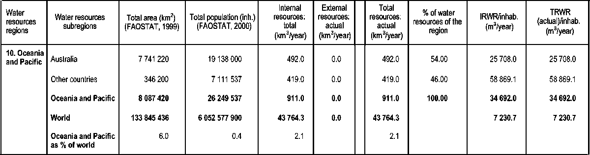
The Oceania and Pacific region covers a total area of 8 million km2, or 6 percent of the world’s total land area, and is home to 0.4 percent of the world’s population. It can be subdivided into two subregions:
Australia: Australia;
Other countries: Fiji, Hawaii (United States of America), New Caledonia (France), New Zealand, Polynesia (France), Solomon Islands, and other Pacific islands.
The countries of this region are mostly islands of very different types as they range from 18 000 km2 to 7 million km2 in area. Therefore, there are no exchanges of water resources between the countries and no homogeneity in their situations. Some of the islands have a tropical climate governed mainly by the change between the wet season, with heavy rainfall, and the dry season. About 75 percent of the total rainfall occurs during the wet season. This results in a large difference in the water level in rivers between the wet and the dry seasons.
The large islands such as Australia and New Zealand have different climates (from very dry to humid). Australia is dry, with an uneven geographical and seasonal distribution of rainfall. River flows are highly variable, under the influence of an erratic climate. Diversion of water into irrigation has altered river runoffs significantly, leading in some cases to the reversal of the flow of some rivers. Australia has one of the world’s largest aquifer systems, the Great Artesian Basin (GAB) estimated at 1.7 million km2 and a storage volume of 8.7 km3. Each year the GAB supplies 0.57 million m³ of water for a variety of uses dominated by pastoral enterprises.
Table 27 presents the water resources of the countries of the region. Some countries, mainly islands, have been omitted because of lack of data.
TABLE 27: Water resources in the Oceania and Pacific region
![]()
![]()
![]()