


The patterns of woodfuel production and consumption, and their associated social, economic and environmental impacts, are rather complex and very site specific (Mahapatra & Mitchell, 1999; RWEDP, 1997 and 2000). Broad generalizations of woodfuel situations at regional, national and even at sub-national level, based on a poor understanding of area-based wood energy systems, still commonly lead to biased assumptions and, consequently, to poor planning and ineffective action (RWEDP, 2000). For example, regarding environmental impacts, even in regions with an overall negative woodfuel demand/supply balance, not all areas within the region face woodfuel scarcity, and, similarly, regions with a positive overall balance may include deficit areas with serious impacts on natural resources (FAO, 1981; RWEDP, 1997 and 2000). In fact, reliance on very general and aggregated information on woodfuel has historically led to misleading conceptions about the effect of woodfuel use on the environment and its sustainability: from pointing to woodfuels as major direct causes of deforestation and forest degradation (like in the woodfuel crisis approach1) (Geist & Lambin, 2002; Detrinidad, 1993; Goldemberg, 1985), to the denial of any significant influence of woodfuels on these processes (ESMAP, 2001). Therefore, detailed surveys at the local level are required before such conclusions can be reached (WRM, 2001; Kaale, 1990; Clarke & Shrestha, 1989).
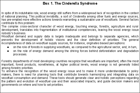
On the other hand, thorough local studies are sometimes implemented, such as the area based woodfuel flows analysis2, but these approaches are expensive and time consuming, and they often remain confined and sporadic, thus failing to convey the holistic, national perspective needed for the design of effective national policies. This problem partly explains why wood energy issues and their associated woodfuel aspects are receiving marginal attention in energy, forestry and rural development sector policies and programmes (see box 1: The Cinderella Syndrome).
Here, it is argued that a correct assessment of the implications of the current patterns of woodfuel use and the sustainable potentials of woodfuel resources, particularly within developing countries, require a better knowledge of the spatial patterns of woodfuel supply and demand. There is a need to conduct multi-scale spatially-explicit analyses of woodfuel supply and demand3 that are able to articulate the local heterogeneity into the regional and national levels (RWEDP, 1997). Studies with full country coverage based on a consistent integration of data at lower scales, disaggregated enough to guide decisions on priority areas or hot spots for intervention, are critically lacking.
A detailed spatial representation of the patterns and likely future evolution of woodfuels use is also required for correctly estimating the sustainable supply4 for woodfuel resources (FAO, 1981). In these regards, one should realize that obtaining exact measures of woodfuel deficits (i.e. like the studies conducted using the traditional fuelwood gap model (De Montalambert and Clement 1983; Newcombe 1984)) presents tough methodological and financial challenges, particularly considering the scarce resources normally allocated to this specific sector (ESMAP, 2001). More feasible approaches are those oriented to identifying problematic or potential areas within a country based on identifying woodfuels patterns and trends. In a second step, more in-depth analyses can be conducted, allowing a more efficient use of the scarce resources available and producing better results.
Currently, however, little has been done in this area. Most detailed studies on woodfuel use patterns and supplies have been conducted at the local level, which presents serious problems for integrating the information at the national level (Masera et al, 1998). In most cases, national-level data is too aggregated to provide the sense of local variance, while local studies, although sometimes of high quality, are too fragmented and discontinuous to convey the general picture. Still little is known, for example, about the amounts, extent, geographical location and dynamics of wood supplies: from plantation strategies to traditional wood collection and harvesting methods (Kartha and Leach, 2001). Analyses of wood resources need to go beyond conventional forest inventories to integrate the whole landscape: agriculture, pasture, forests and home gardens (RWEDP, 2000). Also, analyses of woodfuel demand need to integrate the whole range of urban and rural users, the different fuels (fuelwood, charcoal, and others) as well as household and productive uses (Kartha and Leach, 2001).
This paper introduces Woodfuel Integrated Supply/Demand Overview Mapping (WISDOM), a spatially-explicit planning tool for highlighting and determining woodfuel priority areas or woodfuel hot spots. We recognize that woodfuels are connected to a set of interrelated socioeconomic and environmental issues, and thus woodfuel hot spots can be defined in terms of their relevance in consumption patterns, production, and potential environmental impacts.
Woodfuel hot spots can thus be established according to a number of criteria set by the users. For example, if identifying areas with potentially large social impacts is important, zoning can be done according to the number and density of woodfuel users and the scarcity of woodfuel resources. Studies looking at potential degradation caused by woodfuels will attempt to identify regions where woodfuel consumption is high, resilient, and increasing, where woodfuel supply is at risk, due to loss or degradation of natural vegetation, and where the demand-supply balance indicates a deficit or is likely to develop such a condition in the near future.
WISDOM will not replace a detailed national biomass demand/supply balance analysis for operational planning but rather it is oriented to support a higher level of planning, i.e. strategic planning and policy formulation, through the integration and analysis of existing demand and supply related information and indicators. Rather than absolute and quantitative data, WISDOM is meant to provide relative/qualitative values such as risk zoning or criticality ranking, highlighting, at the highest possible spatial detail, the areas deserving urgent attention and, if needed, additional data collection. In other words, WISDOM should serve as an ASSESSING and STRATEGIC PLANNING tool to identify priority areas for action.5
WISDOM is based on:
Geo-referenced data bases. A core feature of the approach is the spatial base on which the data is framed. The analysis and presentation of results for all modules is done with the help of a Geographic Information System (GIS).
Minimum spatial unit of analysis at sub-national level. The spatial resolution is defined at the beginning of the study, on the basis of the desired level of detail (national study, regional study) and as constrained by the main parameters or proxy variables that will be used to spatialize the information. In most cases the existing demographic data, such as census units, and land use/land cover data represents the main reference for the definition of the spatial base, which will be sub-national and preferably below state level in all cases.
Modular and open structure. WISDOM consists of three basic modules: a demand module, a supply module and an integration module. The first two modules require different competencies and data sources. Once the common spatial base of reporting is defined, each module is developed in total autonomy using existing information and analytical tools and is directed to the collection, harmonization, cross-referencing and geo-referencing of relevant existing information for the area of study.
Adaptable framework. As mentioned previously, the information of relevance to wood energy comes from multiple sources , ranging from census data to local pilot studies or surveys, to projected estimates with unknown sources, and is often fragmented and poorly documented. Proxy variables may be used to spatialize discontinuous values. In synthesis, WISDOM tries to make all existing knowledge work for a better understanding of woodfuel consumption and supply patterns.
Comprehensive coverage of woodfuel resources and demand from different users. The analytical framework considers the inclusion of all sources of woodfuels (i.e. fuelwood and charcoal) coming from: forests (commercial and non-commercial), trees outside forests, shrubs and woodland. The different woodfuel users are also considered: rural and urban households, small industries, etc.
The benefits of WISDOM include:
It provides a consistent and holistic vision of the wood energy sector over the entire country or region and helps to determine priority areas for intervention.
It constitutes an open framework and a flexible tool meant to adapt to existing information related to woodfuels demand and supply patterns.
It allows the definition of critical data gaps resulting from the thorough review and harmonization of wood energy data.
It promotes cooperation and synergies among stakeholders and institutions (Forestry, Agricultural, Energy, Rural Development, etc.). In this, WISDOM will combat the fragmentation (of information, of responsibility) that so heavily limits the development of the sector.
It allows the concentration of actions on circumscribed targets and thus to optimize the use of available resources (human, institutional, financial, etc.)6
It enhances the political recognition of the real inter-sectoral role and priorities of wood energy by policy makers.
In the following chapters, the WISDOM approach is described in detail and illustrated with examples from a country case study in Mexico.
1
For a review of the woodfuel crisis approach and
main premises see ESMAP (2001) and Masera (1995).
2 The area based woodfuel flows analysis is a methodological approach for the analysis of the local dynamics of wood energy systems. It was applied in several countries (see Masera et al, 1997 for the case of Mexico) and
the results of these local investigations were expanded at national level and
used to guide energy actions and interventions. Although this approach provides
the information needed to understand wood energy situations in a given country,
especially at local level, it is expensive and time consuming.
3 In this
document we use the terms woodfuel supply and woodfuel production
indistinctively; we also use the terms woodfuel demand and woodfuel
consumption indistinctively, as they are used always within a technical, as
opposed to an economic, connotation.
4 For example, most current studies on the global potential for biomass energy are still based on rough calculations over entire regions or they rely on a very coarse spatial grid (Hoogwijk et al, 2002). More accurate estimates
regarding the biomass energy potential need to be based on more disaggregated
information on the patterns of local consumption and supply of
woodfuels.
5
Presently, WISDOM concentrates on woodfuels. However,
adjustments can be made to incorporate the entire range of biofuels (agriculture
residues, manure, wastes and residues from forests and agricultural activities,
municipal solid wastes, etc.) into the approach.
6 One such
action would probably be the collection of up-to-date local data to confirm the
results of national or regional analyses (which are always based on information
of lower quality and resolution), and to create a database for operational
planning.