Brief description of selected digital maps extracted from GeoNetwork18, the FAO portal to spatial data and information.
Administrative maps
|
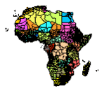
Administrative units in Africa (1993). Potential application for a WISDOM analysis: SPATIAL BASE: 1st and 2nd Sub-National Administrative Level. |
ISO Topic Category |
Boundaries. |
Theme keywords |
Administrative boundaries, Sub-national boundaries, Boundaries. |
Place keyword |
Africa. |
Publication date |
1993 |
Abstract describing the datasets |
National and sub-national administrative boundaries of Africa. Administrative map of Africa clipped. |
|
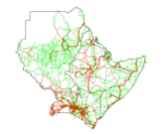
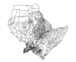
Administrative units in Northeast Africa. Potential application for a WISDOM analysis: SPATIAL BASE: 1st and 2nd Sub-National Administrative Level. | |
ISO Topic Category |
Boundaries. | |
Theme keywords |
Boundaries, Horn of Africa, Administrative boundaries, Northeast Africa. | |
Place keyword |
Africa. | |
Publication date |
1994 | |
Abstract describing the datasets |
Administrative units in Djibouti, Eritrea, Ethiopia, Kenya, Somalia, Sudan and Uganda. | |
Additional information |
The region is subdivided into 1220 homogeneous map units which correspond to administrative units. The level of units used in the individual countries are the following and are presented by: Country name, Adminstrative units, and number of units: Djibouti, Districts, 5; Eritrea, Woredas, 40; Ethiopia, Awrajas, 309; Kenya, Districts, 41; Somalia, Degmadas, 74; Sudan, Area councils, 85; and Uganda, Counties, 143. | |
Purpose |
To enhance crop monitoring and forecasting procedures of regional and national early warning units. | |
Lineage statement |
||
Technical Contact |
Name: |
Freddy Nachtergaele |
Unit: |
AGLL | |
Organization name: |
FAO-UN | |
Scale |
1:5,000,000 | |
Edition |
First version. | |
|
Protected Areas of Africa. Potential application for a WISDOM analysis: SUPPLY MODULE: accessibility indexes. | |
ISO Topic Category |
Biota. | |
Theme keywords |
Biota, PROTECTED FORESTS, NATURE RESERVES, NATURE CONSERVATION, FOREST RESERVES. | |
Place keyword |
Africa. | |
Publication date |
1990 | |
Abstract describing the datasets |
Areas qualified for inclusion in The World Conservation Union management categories I-VIII, prepared by the World Conservation Monitoring Centre (WCMC), Cambridge, U.K. | |
Technical Contact |
Name: |
FAOGIS |
Unit: |
SDRN | |
Organization name: |
FAO-UN | |
Scale |
1:5,000,000 | |
Map quality comment |
Good. Please note that a few conservation areas are very small and thus difficult to visualize on a static GIF map. | |
Population distribution
|
Population density of Africa. Potential application for a WISDOM analysis: DEMAND MODULE. | |
ISO Topic Category |
Society. | |
Theme keywords |
Society, POPULATION DISTRIBUTION, POPULATION DENSITY. | |
Place keyword |
Africa. | |
Publication date |
1996 | |
Abstract describing the datasets |
Population density estimates per sqkm. | |
Technical Contact |
Name: |
Freddy Nachtergaele |
Unit: |
AGLL | |
Organization name: |
FAO-UN | |
Map quality comment |
Good, of historical importance. | |
|
Rural population in Sub-Saharan Africa. Potential application for a WISDOM analysis: DEMAND MODULE. | |
ISO Topic Category |
Society. | |
Theme keywords |
Global Farming Systems Study, POPULATION STRUCTURE, Society, Sub-Saharan Africa. | |
Place keyword |
Africa. | |
Publication date |
2001 | |
Begin date |
2001 | |
End date |
||
Abstract describing the datasets |
As part of the the World Bank's review of its rural development strategy, the Bank sought the assistance of the Food and Agriculture Organization of the United Nations (FAO) in evaluating how farming systems might change and adapt over the next thirty years. Amongst other objectives, the World Bank asked FAO to provide guidance on priorities for investment in food security, poverty reduction, and economic growth, and in particular to identify promising approaches and technologies that will contribute to these goals. The results of the study are summarized in a set of seven documents, comprising six regional reports and the global overview contained in this volume. This document, which synthesises the results of the six regional analyses as well as discussing global trends, cross-cutting issues and possible implementation modalities, presents an overview of the complete study. This document is supplemented by two case study reports of development issues of importance to farming systems globally. | |
Additional information |
Data from the Oak Ridge National Laboratory, LandScan Global Population 1998 Database. Estimates for rural population were obtained by excluding the Urban Population Areas. This was achieved by removing settled and partly settled grid cells from the Landcover Dataset and removing (limiting) population density figures to produce a net result which approximates the known rural population. Raster data-set has been exported as ASCII raster file type. | |
Purpose |
The farming systems presented in this study are considered to provide an effective broad framework for the prioritisation of development actions and investments for accelerating agricultural development, particularly in ways which can reduce rural poverty and hunger. | |
Technical Contact |
Name: |
FAOGIS |
Unit: |
SDRN | |
Organization name: |
FAO-UN | |
|
Roads in Northeast Africa. Potential application for a WISDOM analysis: SUPPLY MODULE: accessibility indexes. | |
ISO Topic Category |
Transportation. | |
Theme keywords |
Transportation, ROADS, ROAD TRANSPORT, INFRASTRUCTURE, Northeast Africa, Horn of Africa. | |
Place keyword |
Africa. | |
Publication date |
1994 | |
Abstract describing the datasets |
Roads in Djibouti, Eritrea, Ethiopia, Kenya, Somalia, Sudan and Uganda. | |
Purpose |
To enhance crop monitoring and forecasting procedures of regional and national early warning units. | |
Technical Contact |
Name: |
Rene Gommes |
Unit: |
SDRN | |
Organization name: |
FAO-UN | |
Scale |
1:5,000,000 | |
Edition |
First version. | |
|
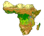
ORNL Land cover of Sub-Saharan Africa. Potential application for a WISDOM analysis: SUPPLY MODULE: biomass stocking estimates. | |
ISO Topic Category |
ImageryBaseMapsEarthCover. | |
Theme keywords |
Global Farming Systems Study, LAND USE, ImageryBaseMapsEarthCover, Sub-Saharan Africa. | |
Place keyword |
Africa. | |
Publication date |
2001 | |
Begin date |
2001 | |
Additonal information |
Data from the Oak Ridge National Laboratory, LandScan Global Population 1998 Database. The LandScan Land Cover Database is derived from the U.S. Geological Survey's (USGS) Global Land Cover Characteristics (GLCC) database with the following substantial modifications: 1. The LandScan Land Cover Database has been georegistered at 30 arc second resolution in a common grid for the entire globe. The original GLCC database was in Goode's Homolosine projection. 2. Considerable effort has been devoted to reconciling the positional accuracy of diverse global databases. Mismatches among databases were most conspicuous on coastlines. On the southern coast of France, for example, positional errors amounted to several kilometers, and these have been corrected. Globally, the LandScan Land Cover database coastlines are based on NIMA's World Vector Shoreline (WVS) on a 1:250,000 scale. Typically, this coastline differs somewhat from the related line representing the seaward boundary of administrative units, and both of these differ from the land/water boundary indicated on the GLCC gridded database. In the final LandScan Land Cover Database, Version 1.1, the WVS takes precedence, and water is assigned to all cells extending more than one-half cell beyond the WVS coastline. Wherever the land surface had to be expanded to reach the WVS shoreline, we inserted an unclassified land. 3. The LandScan Land Cover Database contains a much improved urban class. We replaced the USGS urban class with two new classes: developed and partly developed. The developed class is composed of GLCC's urban cells plus all cells included in the Census Bureau's P-95 circles. The partly developed class is derived from Nighttime Lights of the World and contains all cells with a frequency value of 90% or greater. The the partly developed class typically includes suburban areas, small towns, and scattered industries, airports, etc. | |
Purpose |
The farming systems presented in this study are considered to provide an effective broad framework for the prioritisation of development actions and investments for accelerating agricultural development, particularly in ways which can reduce rural poverty and hunger. | |
Lineage statement |
||
Technical Contact |
Name: |
FAOGIS |
Unit: |
SDRN | |
Organization name: |
FAO-UN | |
|
Soil fertility index for Africa. Potential application for a WISDOM analysis: SUPPLY MODULE: biomass productivity estimates. | |
ISO Topic Category |
Geo-scientific Information. | |
Theme keywords |
SOIL FERTILITY, Geo-scientific Information. | |
Place keyword |
Africa. | |
Publication date |
1997 | |
Abstract describing the |
FAO/UNESCO soil map of the world interpreted in terms of soil fertility datasets | |
Technical Contact |
Name: |
Freddy Nachtergaele |
Unit: |
AGLL | |
Organization name: |
FAO-UN | |
Scale |
1:5,000,000 | |
|
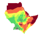
Length of Growing Period (LGP) in Northeast Africa. SUPPLY MODULE: biomass productivity estimates. | |
ISO Topic Category |
Farming. | |
Theme keywords |
Farming, Horn of Africa, CROPS, CLIMATE, Northeast Africa. | |
Place keyword |
Africa. | |
Publication date |
1994 | |
Abstract describing the datasets |
Length of growing period in Djibouti, Eritrea, Ethiopia, Kenya, Somalia, Sudan and Uganda. | |
Additional information |
For planning purposes, and to ensure compatibility with other background data (such as demographic and agricultural statistics), the information is presented according to geographic units largely following administrative boundaries. The region was therefore subdivided into 1220 homogeneous map units which correspond to administrative units, or subdivisions thereof whenever steep ecological gradients occur. These map units constitute the basic elements shown in this map. | |
Purpose |
To enhance crop monitoring and forecasting procedures of regional and national early warning units. | |
Technical Contact |
Name: |
Rene Gommes |
Unit: |
SDRN | |
Organization name: |
FAO-UN | |
Scale |
1:5,000,000 | |
Edition |
First version. | |
|
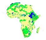
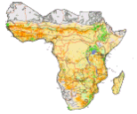
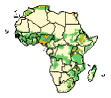
Permanent crop and arable land of Sub-Saharan Africa. Potential application for a WISDOM analysis: SUPPLY MODULE: non-forest fuelwood productivity estimates.
| |
ISO Topic Category |
Farming. | |
Theme keywords |
Global Farming Systems Study, ARABLE LAND, CROPS, Farming, Sub-Saharan Africa. | |
Place keyword |
Africa. | |
Publication date |
2001 | |
Additional information |
Derived by CGIAR from the USGS Earth Resources Observation System (EROS) Data Centre (EDC) 1998, 1 km resolution, global land cover characteristics database, version 1.2 which is based on monthly NDVI data from April 1992 to March 1993. Agricultural land includes irrigated and rain-fed cropland, managed pastures, orchards, vineyards and plantations. Sparsely vegetated includes desert, semi-desert and tundra. Raster data-set has been exported as ASCII raster file type. | |
Purpose |
This study is considered to provide an effective broad framework for the prioritisation of development actions and investments for accelerating agricultural development, particularly in ways which can reduce rural poverty and hunger. | |
Technical Contact |
Name: |
FAOGIS |
Unit: |
SDRN | |
Organization name: |
FAO-UN | |
Edition |
First version. | |
18 GeoNetwork is accessible at: http://www.fao.org/geonetwork/srv/en/main.search
)