


Introduction
The recent incursions of foot-and-mouth disease (FMD) and other epizootics into Western Europe have demonstrated the need for adequate livestock data to support epidemiological analysis and define control strategies. In most European Union (EU) countries, analysis is now enhanced by the availability of georeferenced animal identification and registration data and topographical digital charts, which go down to the level of individual farms. Most road networks are known precisely, as are the main routes of animal transport and the location of processing units. Thus, early warning systems and prediction of the likely pattern of disease spread are gradually becoming a reality across most of Europe.
However, these data and tools are generally not yet available in the adjacent countries of Eastern Europe or in much of the rest of the world. It would appear that access to epidemiological data and investment in transboundary animal disease (TAD) control are broadly correlated to the amount of income generated from local livestock production. Indications are that extensive pastoral and nomadic livestock populations in vast tracts of the Near East and Central Asia are kept in situations where production levels remain low and diseases persist in endemic form. Yet, in these dry lands and other harsh environments, livestock is often the single most important means of securing a livelihood. There is considerable marginalization of rural societies because of a combination of interrelated factors including demographic pressure, environmental negligence, ethnic conflict, civil strife, fragile rural economies and unstable governments in incipient democracies.
There is considerable marginalization of rural societies because of a combination of interrelated factors including demographic pressure, environmental negligence, ethnic conflict, civil strife, fragile rural economies and unstable governments in incipient democracies |
In sharp contrast to this are the extensive production environments of the more localized, highly productive, modern livestock industries that are scattered across the Near East, mostly in the proximity of urban centres. For example, profound changes in pastoral livestock production and traditional nomadism in Saudi Arabia over the past half century have resulted in a decline in range forage (used as a basic ruminant feed resource) to less than 20 percent of its original cover. New systems of mechanized nomadism using vehicles and water tanks have evolved. The availability of cheap barley feed, machinery and labour now dictate production volumes throughout the country. As a result, ruminant meat is increasingly produced in modern feedlots, industrial poultry production has become common and dairy farms operate at one of the highest productivity levels in the world.
Clearly, epidemiological analysis along transects that range from disease free to fully endemic poses a major challenge. It requires a more composite, geographic picture of the whole circuitry of available land and water resources (forage and feed, animal distribution, fattening, transport, marketing, processing, distribution, consumption and waste disposal), presented in an adequate form for clarifying the epidemiology of FMD and other TADs. The following paragraphs give brief descriptions of some of the recent activities in this regard that the FAO Animal Health Service has initiated and coordinated, and suggestions on how to enhance this work.
Livestock geography and land use
Many countries do not have adequate systems for collecting, analysing and reporting livestock population or general agricultural statistics |
Many countries do not have adequate systems for collecting, analysing and reporting livestock population or general agricultural statistics. Available information about livestock resources is often incomplete and of doubtful reliability, and so alternative means of assessing land cover and livestock resources in remote and inaccessible regions need to be considered.
Livestock dynamics in the Arabian Peninsula
A recent FAO report (FAO, 2003a) provides a review of national and regional livestock resources and trade in the Arabian Peninsula. The available information on animal protein demand, livestock distribution, trade and movements has been collated with the aim of assisting the epidemiological analysis of TADs in the Arabian Peninsula (Bahrain, Kuwait, Oman, Qatar, Saudi Arabia, the United Arab Emirates and Yemen) and neighbouring Iraq, Jordan and the Syrian Arab Republic.
Livestock trade in the region is driven by demand from the Gulf States |
The demand for sheep in the Arabian Peninsula varies during the year, peaking during religious festivals. During the month of Ramadan, the ninth month of the Muslim calendar, adherents fast during the day and eat in the evening or early morning. A three-day holiday period known as Eid ul Fitr (Feast of Fast Breaking) celebrates the end of Ramadan. A second festive occasion, Eid ul Adha (Feast of Sacrifice), is celebrated on the tenth day of the month of Zul-Hijja, a few months after Ramadan, when many Muslin families sacrifice a sheep.
Livestock trade in the region is driven by demand from the Gulf States (Bahrain, Kuwait, Oman, Qatar, Saudi Arabia and the United Arab Emirates), which collectively accounted for 71 percent of the recorded 11.3 million live sheep, goats and cattle imported in 2000 and 2001. In 2002, Saudi Arabia was by far the world's largest importer of live animals, with 4.2 million sheep and 1.1 million goats.
In recent decades, there have been significant changes in the mode of livestock production, including increased availability and utilization of crop residues, widespread supplementary animal feeds, mechanized pastoralism and the introduction of modern dairy and poultry production units. The seasonal and tribal movement patterns of traditional nomadism and transhumance have been transformed, especially in Iraq, Jordan, Saudi Arabia and the Syrian Arab Republic. With transport to supply animal feeds and tank trailers to provide water, pastoral livestock production is less dependent on rainfall and range conditions than it was. Traditional seasonal patterns of movement to and from specific areas have been replaced by more erratic and opportunistic movements to areas with seasonable crop residues and natural pasture, where water and supplementary feed can be supplied.
Satellite imagery and seasonal animal movement
One of the products resulting from the integration of satellite imagery and GIS data is the display of seasonal availability of grazing |
Satellite imagery provides geospatial information on environmental variables, such as those related to climate, ecozones, vegetation patterns and general land cover. Satellite data are integrated with data from geographic information systems (GIS) to produce novel, digital maps that demarcate grazing areas, farming systems and ruminant livestock distributions. Where satellite imagery is available in time series form, it becomes possible to plot the dynamics of the farming landscape.
One of the products resulting from the integration of satellite imagery and GIS data is the display of seasonal availability of grazing. This information facilitates the definition of livestock husbandry patterns considerably, and therefore provides insight into the understanding of disease spread.
Geospatial models for disease spread
A training module on spatial epidemiology simulates the spread of any contagious ruminant disease under the circumstances prevailing in the Near East and Central Asia. The model is user-friendly, adaptable and generic. Livestock husbandry and other environmental layers generated in a GIS environment are introduced directly into the model in order to improve the prediction of disease spread. The model is generic in that the spread of pathogens is simulated on the basis of the characteristics of the livestock production environment. Concerning the disease itself, the model is specific regarding the basic reproductive rate, the transmission rate, host recovery, the immunity level, etc.
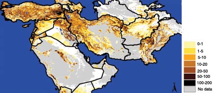
Annual mean sheep density, per square kilometre
Source: FAO, 2003b
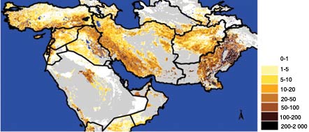
Annual mean goat density, per square kilometre
Source: FAO, 2003b
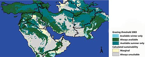
Seasonal grazing availability in 2003
Source: FAO, 2003b
One of the main purposes of geospatial models is to accommodate both short-range, stochastic spread and medium- to long-range jumps. In extensive ruminant livestock systems in Central Asia and the Near East, disease pathogens travel in a somewhat continuous fashion from flock to flock and from village to village, whereas jumps can occur when animals are moved on foot or by truck over long distances. The passive movement of animals is in response to the erratic availability of grazing, pasture seasonality or food-chain-related transports, such as for fattening, marketing, slaughter or direct sales in urban centres. The combination of short- and long-range dispersal is known as “stratified dispersal”, and dispersal is also characterized by the establishment of new outbreaks ahead of the moving frontline.
The simulation becomes more realistic when masks are incorporated, such as that for the presence of unsuitable areas where no animals can be kept. Any other GIS layers with spatial information about the probability of local disease spikes taking place can be accommodated. In most scenarios, the most important layer forms animal density, which acts as a major risk multiplier. Conversely, the animals behind the travelling frontline die or become immune and make the disease fade out. Satellite-derived local grazing availability can be translated into seasonality multipliers, so that local livestock densities are adjusted continually to the available grazing. This opens the door to the real-time monitoring of animal production and health features.
Conclusions
Critical gaps in epidemiological information can be overcome to include the dynamic TADs of the Near East and Central Asia. In order to collate the missing information, it is first necessary to establish strong regional networks for improved early warning and early reaction. These networks need to be based on enhanced information and communication functions and tools, including the application of remote sensing systems, GIS and spatial models.
Rinderpest
In January 2003, delegates to the International Office of Epizootics (OIE) declared Pakistan “provisionally free” from rinderpest. In June 2003, the Islamic Republic of Iran was also declared “provisionally free”.
Since the previous EMPRES Bulletin (No. 22 - 2002), the OIE has been notified of outbreaks of EMPRES priority diseases in different regions around the world (January to June 2003):
FAO. 2001. Livestock geography: new perspectives on global resources. CD-ROM. Study carried out by FAO consultants of the Environmental Research Group Oxford Ltd, UK, Avia-GIS, Belgium, and technical staff of the FAO Animal Production and Health Division, Rome. Last update December 2002 (available at http://ergodd.zoo.ox.ac.uk/livatl2/).
FAO. 2002. Environmental health management. Training module on spatial epidemiology. Consultant report by M. Gilbert, Free University of Brussels, Belgium, FAO consultant, December 2002. Rome.
FAO. 2002. Seasonal mapping of climatic and vegetation indices in the Eurasian Ruminant Street. Report by J. Biesemans, Avia-GIS, Belgium, FAO consultant, December 2002. Rome (available at http://www.avia-gis.com/WWW_en/index_en.html).
FAO. 2003a. Livestock dynamics in the Arabian Peninsula. A regional review of national livestock resources and international livestock trade, by D. Bourn. Rome (available at http://ergodd.zoo.ox.ac.uk/download/index.htm).
FAO. 2003b. Ruminants, seasons and grazing in the Middle East, by W. Wint. Rome (available at
http://ergodd.zoo.ox.ac.uk/download/index.htm).
Key points 1. A four-month pilot study, involving a number of experts from FAO, Turkey, the Islamic Republic of Iran and European institutions, was conducted to explore the potential for improving understanding of the relationship between the animal production and trade environment and FMD occurrence. 2. The study brought together a great amount of information, and predictive geospatial models to explore FMD risk more effectively were developed. 3. The study highlighted the potential for using remote sensing and GIS-based information systems to integrate the multiple factors that drive animal movement in the region and to present them in a useful form. 4. Such systems might be useful in analysing and predicting the risk of FMD virus movement across the Near East and in identifying critical control points. 5. Understanding and utilizing the knowledge of risk factors for animal movement might also be extremely important for the control of other dynamic TADs in the Near East and Central Asia. 6. In order to collate the missing information, it is first necessary to establish strong regional networks for early warning and early reaction, based on enhanced information and communication functions and tools, including the application of remote sensing, GIS and spatial models, as applicable and desired. 7. As a potential way ahead, the member countries of the FAO/International Fund for Agricultural Development (IFAD) Regional Animal Disease Surveillance and Control Network (RADISCON) project expressed a strong interest in developing a network for the analysis of animal movement risks in the Near East. 8. Animal health management is only one element of animal production as a whole. Unless the income generation prospects of remote pastoral ocieties are improved, it will be difficult to step up TAD control across the Near East and Central Asia. |
Disease |
Country |
Date |
Location |
Agent characterization |
Contagious bovine pleuropneumonia |
Eritrea |
April 2003 |
Asmara |
|
Classical swine fever |
Bulgaria |
February 2003 |
Silven and Kerme (Silven Region) and Yasna Polyana village (Burgas Region) |
|
Germany |
March 2003 |
Bad Dürkheim district, Rhineland-Palatinate Land |
||
Republic of Korea |
March 2003 |
Iksan City, Chonbuk Province, in the south of the country |
||
African swine fever |
Congo |
June 2003 |
Harbour city of Matadi, Lower Congo Province |
|
Rift Valley fever |
Gambia* |
February 2003 |
8 locations in the valley of the River Gambia |
|
Foot-and-mouth disease |
Botswana |
February 2003 |
Strauss Farm, Tsiteng, Matopi, A Black Bearded Farm |
FMD SAT 1 |
Hong Kong SAR |
February 2003 |
Yuen Long and Kam Tin (District 8) |
Not typed |
|
Malawi |
June 2003 |
Blantyre and Shire Valley |
FMD SAT 2 |
|
Libyan Arab Jamahiriya |
June 2003 |
In the northwest of the country: provinces of Sabratah and Az Zawiyah |
FMD SAT 2 |
|
United Arab Emirates |
May 2003 |
Dubai |
Virus serotype O |
|
Highly pathogenic avian influenza |
Netherlands |
From March 2003 |
provinces of Gelderland, Utrecht (March 2003), Noord-Brabant, Limburg (April 2003) |
Highly pathogenic avian influenza virus subtype H7 |
Belgium |
From April 2003 |
Limburg Province, Antwerp Province |
Highly pathogenic A/chicken/Belgium/6175/03 (H7N7) virus |
|
Germany |
May 2003 |
Schwalmtal municipality, Viersen District, North Rhine-Westphalia Land |
Avian influenza virus subtype H7 |
|
Hong Kong SAR |
January 2003 |
Penfold Park, Shatin, Kowloon Park, Kowloon, Lok Ma Chau, New Territories |
Highly pathogenic avian influenza virus H5N1 |
|
Peste des petits ruminants |
Mali |
January 2003 |
Dogoni community, Sikasso District, Sikasso Region, Ségou community, Ségou District, Ségou Region |
|
Bluetongue |
Serbia and Montenegro |
January 2003 |
Ub, Šabac, Kosjeric, Kraljevo, Priboj |
|
Tunisia |
January 2003 |
Kairwan Governorate, Monastir Governorate |
||
Singapore |
February 2003 |
Mandai |
||
Albania |
February 2003 |
Librazhd, in the east of the country |
||
* Information from FAO because the Gambia is not an OIE member country. |
||||
