![]()
![]()
![]()
Population
The ten countries concerned have a combined population of 117 million, representing 14 percent of the total population of Africa. South Africa has by far the largest population of the ten countries, while those of Botswana, Lesotho, Namibia and Swaziland are small (Annex 1 for population and economic data). Average annual population growth for the ten countries (2.2 percent) is lower than that for Africa as a whole (2.8 percent) and higher than that for the world (1.5 percent). Within the group, annual population growth ranges from 3.2 percent for Angola to 1.7 percent for South Africa.
Urbanization and industrialization have had a modest impact on the rural and agricultural populations. The proportion of the population living in rural areas has fallen in all ten countries, but only in South Africa has the absolute rural population fallen. The agricultural population of the ten rose by a total of 7.7 million between 1991 and 2001, with only South Africa able to reduce dependency on agriculture to provide employment. Since 1991, Angola, Malawi, Mozambique and Zambia have each added more than 1 000 000 to the number of people depending on agriculture. The pressure on natural resources is increasing as agriculture is asked to provide livelihoods and food for rising populations.
Economic growth
The economies of the ten countries are small and have narrow production bases. Among the world’s economies, South Africa (which generates 75 percent of the total national income of the ten) ranks 34 by size and the others from 85 to 152. Gross national income (GNI) per person for the ten averages US$1 330 and ranges from US$3 100 for Botswana to US$160 for Malawi. The ten countries rank between 89 and 199 among the 208 in the World Bank’s estimates of income per person.
Only South Africa has a truly diversified economy, with 8 percent of its output coming from agriculture and major contributions coming from higher-value mining, manufacturing and services sectors. Botswana and Angola, where mining is important, have agriculture sectors contributing 4 and 12 percent of gross domestic product (GDP). The other economies have a much greater dependence on agriculture, the highest being for Mozambique (64 percent of GDP), Malawi (64 percent) and Zambia and Zimbabwe (20 percent each).
Annual economic growth for the ten was considerably different in the 1990s to that in the 1980s. In the 1990s, economic growth in Mozambique and Namibia was much higher and in Malawi and South Africa moderately higher than in the 1980s. Angola, Lesotho and Zambia had slightly lower growth in the 1990s. Growth in Botswana, Swaziland and Zimbabwe slowed greatly in the 1990s.
The highly variable annual economic growth rates are headed by Mozambique (6.7 percent in the 1990s), Botswana (5.2 percent) and Namibia (4.6 percent). The countries with generally the worst poverty indicators(Malawi, Mozambique, Zambia and Zimbabwe)had mixed experiences of total and agricultural growth in the 1990s. Mozambique enjoyed the highest economic growth and, relative to other countries, high agriculture growth. Malawi had the fifth fastest national growth but topped agriculture sector growth. Zambia and Zimbabwe had among the lowest national growth rates and were in the middle of agriculture sector performers.
Growth in the agriculture sector was able to outpace that of the national economy only in Malawi, Zambia and Zimbabwe in the 1990s, but was generally able to grow faster than the population depending on it. Compared with population growth, sector product growth was much higher in Malawi, Mozambique and Namibia, and much lower in Angola and Botswana. The overall picture is one of modest growth in both the agriculture sectors and the national economies relative to population. Growth in the non-farm sectors has been insufficient to reduce dependence on agriculture for employment or income.
Food crops. There has been little overall change in the production of the four major staples (maize, sorghum, pulses and millet) in recent decades (Annex 2 for selected food crop production data). While there have been substantial shifts within individual countries, the overall outcome for the ten is that the rate of increase in production of these crops has not matched that of population. Supply to the ten countries of these key staples is generally keeping pace with population growth. Trade in these commodities is minor; in the past three decades, there have been small increases in imports and reductions in exports.
Yields for the four crops vary considerably from year to year (Figure 1) and from country to country. The greater annual variation in the yield of maize and sorghum reflects the fact that they are less drought tolerant than millet.
Figure 1
Average yields of food
crops
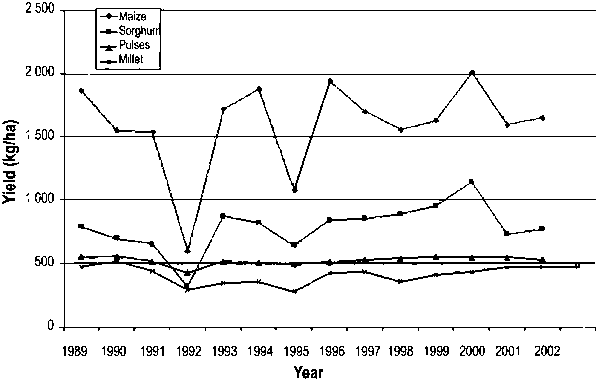
Maize, the dominant staple for the great majority of the region’s people, is the greatest user of agricultural land, about 9.2 million ha. Total production in 2000 (three-year average 1999-2001) exceeded that for 1990 (three-year average 1990-92) by 1 percent. There was little overall change in area (-1 percent) or yield (+5 percent). Lesotho, Malawi and Mozambique increased production by expanding area and raising yields and Angola by a greatly higher yield from reduced area. South Africa, Swaziland and Zimbabwe reduced both area and yield. Maize supply to domestic markets has been increased primarily by reduced exports, especially in South Africa. Angola, Lesotho, Malawi and Mozambique have increased supply much faster than their populations, by large rises in production and reductions, or restrained increases, in imports.
Sorghum, the second most important grain crop, uses about one-tenth as much land as maize. The sorghum production of the ten countries rose by about 20 percent between 1990 and 2000, with a 29-percent increase in yield more than offsetting a 15-percent reduction in area. Lesotho, Malawi and Mozambique accounted for almost all of this increase, all three expanding area and raising yield. Zambia and Zimbabwe increased production marginally, the former by expanding area and the latter by raising yield. Botswana, Namibia, South Africa and Swaziland reduced their sorghum area substantially. Sorghum supply has increased in line with production, with only Botswana and South Africa increasing exports and all countries’ imports remaining largely unchanged.
Production of pulses, which are critical to sound nutrition, increased by 20 percent between 1990 and 2000 as total area expanded by 18 percent and yield by 2 percent. Angola, Lesotho and Mozambique increased area and yield substantially to gain the greatest proportional increase in production and account for the great majority of the subregion’s additional output. South Africa and Swaziland retreated from sorghum production with large reductions in area and small changes in yield. Zambia increased area significantly to offset a large fall in yield. The supply of pulses is increasing steadily in all countries except Malawi and Namibia. Imports are significant only in South Africa and Angola.
Millet is an important grain source in dry agropastoral areas, largely because of its tolerance of drought. Overall, the area of millet changed little during the 1990s. However, there were large proportional and absolute increases in area in Angola and Namibia with the former having a slight increase and the latter a large fall in yield. Production fell sharply in Zimbabwe as both area and yield fell. The expansion of the millet supply is steady and uniform across the countries with drier climates, except for Zimbabwe where it has fallen rapidly. The region’s trade in millet is negligible.
Roots and tubers are a major user of land and a critical source of food. Total area is expanding considerably, especially in Angola, Mozambique and Zambia, in all of which production is rising steadily.
Cash crops. Recent changes in the area cropped and the output of major cash crops have been more pronounced than those for food crops (Annex 3 for selected cash crop production data). There is considerable variation in production between countries and between crops for selection cash crops (defined here as grown exclusively or primarily for sale). The total output of all the selected crops rose between 1990 and 2000 although their total cropped area fell from 4.6 to 4.0 million ha.
The major shifts in production patterns between 1990 and 2000 were:
Total area fell by about 0.6 million ha.
Total area declined in Lesotho, Mozambique and South Africa.
Reduced wheat area accounted for almost all of the reduction in the total area in South Africa (about 0.8 million ha).
Total production (by volume) increased in all countries except Swaziland.
Total production of each crop increased.
Average yield for each crop increased by 2-106 percent.
South Africa recorded very high increases in wheat, groundnut, sunflower, cotton and tobacco yields.
Malawi increased wheat, rice, groundnut and sunflower yields substantially.
Mozambique increased rice, groundnut, cotton and tobacco yields.
Zambia had large increases in wheat, groundnut and cotton production and a large reduction in that of sunflower, owing to changes in both yield and area.
Zimbabwe had large increases in output of cotton and tobacco (mainly from expanded area) and a large reduction in sunflower area and production.
Figure 2
Average yields of cash
crops
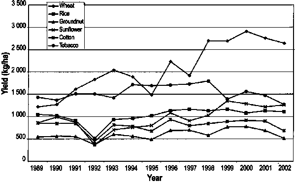
Crop yields vary substantially from year to year (Figure 2) although less than for food crops. Much more exhaustive and detailed analysis would be required to draw valid conclusions about the changes in area, yield and production for cash. However, it is apparent that the incentives and opportunities for cash production are leading these crops in a different direction to that of the food staples.
Many studies have shown that poverty is widespread in most of the ten countries and considerably higher in rural than in urban areas. Statistics and analysis on income, poverty, food supply and composite measures on poverty are available from many sources including FAO, the World Bank, the International Monetary Fund (IMF), the United Nations Development Programme (UNDP), the International Fund for Agricultural Development (IFAD), other UN agencies, governments, non-governmental organizations (NGOs), universities and others. Despite their differing definitions and methods for measuring poverty and arriving at differing estimates of its incidence and extent, the studies are unanimous that poverty is widespread and entrenched. However, there is no unanimity on the immediate and underlying causes of poverty or on solutions.
Among the key indicators of the severe and chronic poverty suffered by the subregion are[2]:
The proportion of the population with an income of less than US$2 per day (UNDP data) is below 50 percent only for South Africa (36 percent) and ranges up to 87 percent (Zambia).
The proportion of the population below the defined national poverty line ranges from 40 to 87 percent of the total, and that of rural people from 54 percent for Swaziland to 88 percent for Zambia and 90 percent for Malawi.
Between 9 and 55 percent of the national populations, a total of some 31 million people, are undernourished (FAO data). Undernourishment, which is worst in Mozambique, Angola and Zambia, increased in the 1990s.
The UNDP’s Human Development Indexes(HDI) of the ten countries range from 107 (South Africa) to 170 (Mozambique) of 173 countries ranked.
A more wide-ranging study on rural poverty by the IFAD (2002) gives useful working descriptions of the poor and of the reasons for their condition. Its conclusions make three important points about the location of the poor:
The majority of the poor are concentrated in densely populated areas.
Although the remote regions with marginal agricultural resources are poorer than other regions, these have a relatively low population and, hence, account for a relatively low proportion of the poor in most countries.
Due to historical circumstances, the majority of the poor in Botswana, Malawi, Namibia and Zimbabwe are found in areas with low agricultural potential, but elsewhere in the region, the majority are in areas with moderate to high agricultural potential.
The IFAD assessment has two important conceptual findings:
“The poor are, in general, very small entrepreneurs - their livelihoods are based on their operation of small businesses - in farming, trading, small services and small industry (and very often a combination of these within a household). Like small entrepreneurs everywhere, their success depends on their own access to capital, markets and technology.”
“The immediate causes of poverty may have been lack of access to assets and to free markets. The underlying cause has been lack of reflection of the interests of the rural poor in key political, economic and institutional processes.”
These conclusion should come as no surprise but at the very least they point to the need to address two fundamental points when seeking to use improved water control as means for escaping poverty. First that stable systems of land tenure and water use rights are essential if smallholders are to invest in water control infrastructure. Second that access to term credit needs to be carefully linked to markets and the availability of correct technologies to reinforce viable production chains. The policy environment to allow this to happen must also be in alignment with protection of fundamental rights in use, provision for their transfer and clear food and agriculture policies.
MAP 1
Agro-ecological zones
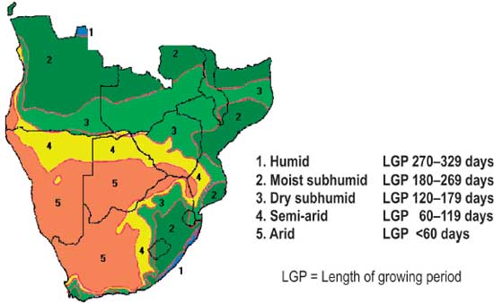
Source: Global Agro-ecological Assessment IIASA and FAO, 2000
The region, except for the Cape in South Africa, experiences a single rainy season in the summer (November-March), in which mean annual rainfall varies from more than 1 000 mm in the Eastern Highlands of Zimbabwe to less than 300 mm towards the Kalahari Desert in the southwest. Mean temperatures are mainly in the range of 18-24 ºC.
The influence of climate on suitability for rainfed crop production is best described by agro-ecological zones (AEZ.) These are defined by the period (in days) when available water and temperature regime permit crop growth (Map 1). Moisture availability is expressed by the concept of length of growing period (LGP), which is the period (in days) during a year when precipitation exceeds half the potential evapotranspiration, plus a period required to evaporate an assumed 100 mm of water from excess precipitation (or less if not available) stored in the soil profile.
The most common cereal food crops need a growing period of at least 90-120 d, which makes the arid zone unsuitable for rainfed cropping and the semi-arid zone very marginally suitable to unsuitable.
The soils in the region can be grouped according to the overriding limitation they pose to cropping:
Sandy and coarse gravelly soils: These cover almost half of the region and are especially extensive in Botswana, eastern Namibia, eastern Angola, western Zambia and southern Mozambique. The main production constraints are low waterholding capacity and high infiltration rate. Nutrient contents and nutrient retention are low.
Poorly drained soils: Seasonally waterlogged soils or soils with high groundwater table occur along drainage lines throughout the region. Large expanses of poorly drained soils occur in the border area of eastern Angola and western Zambia and in the northwest of Botswana. Soils with impeded drainage are also common in South Africa (planosols). The agricultural potential of poorly drained soils varies greatly; they may be of great value in some localities within semi-arid and dry subhumid zones.
Vertisols: These heavy clay soils are subject to shrinking (cracking) when dry and swelling when moist. A large area of vertisols occurs in eastern South Africa and minor areas in most other countries. Vertisols are not inherently unproductive but require special management as they are difficult to work and difficult to fertilize.
Infertile soils(acid soils): This group of soils, characterized by low pH, low cation exchange capacity and low base saturation, is associated with areas of relatively high rainfall in western Angola, northern Zambia, Malawi and northern Mozambique. Acid soils may suffer from aluminium (Al) toxicity and generally pose difficulties for agricultural use.
Steep lands: These are areas with slope inclinations in excess of 12 percent. Soils are often shallow.
Saline/sodic soils: These soils contain considerable amounts of soluble salts. Salt accumulation may occur through natural processes in arid and semi-arid areas, or it may be a result of inappropriate irrigation practices. Salt-affected soils are particularly extensive in southeastern Zambia (Luengwa Valley).
Agricultural practices in the region can be described in terms of farming systems. FAO and the World Bank (2001) classified farming systems of developing regions from the available natural resource base and dominant pattern of farm activities and household livelihoods (Map 2).
Of the 14 major farming systems defined for sub-Saharan Africa, 11 occur in one or more of the ten selected SADC countries (Annex 1 details areas and populations of the farming systems in the ten countries). Four of the defined farming systems are considered to be of minor relevance to this study:
Irrigated: This system comprises large-scale irrigation schemes, which would require individual studies. However, medium and small-scale irrigation, which occurs in many of the other systems, is considered.
Tree crop, forest based, root crop and coastal artisanal fishing: The present study is mainly concerned with the use of water in areas experiencing recurrent droughts and water shortages. This largely excludes farming systems occurring in the subhumid parts of the region, i.e. central and northern Angola, northern Zambia, the extreme north of Malawi and Mozambique and the coastal zone of Mozambique.
Large commercial and smallholder: This is an association of two types of farm: scattered smallholder farming adjacent to large-scale commercial farming. The present study focuses mainly on the smallholder component, without ignoring the possible interaction with the commercial farms.
Sparse (arid): With the exception of the Orange River in South Africa and Namibia, the arid zone has little water and few people.
Map 2
Major farming systems
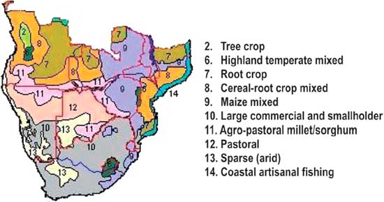
Source: Farming Systems and Poverty by J. Dixon, A. Gulliver with D. Gibbon, FAO and World Bank, 2001
The six farming systems that are the starting point of this diagnostic are:
Highland temperate mixed: This covers most of Lesotho and nearby South Africa and the Eastern Highlands of Zimbabwe. The system covers mountainous terrain with a range of climate conditions with variable rainfall and extreme temperatures. The system is subject to drought and flooding. A diversity of crops is grown, including some temperate annuals and perennials. Livestock is important, as are off-farm incomes and remittances, particularly in Lesotho.
Cereal-root crop mixed: This system predominates in the dry subhumid zone of Angola, Zambia and Mozambique at relatively low altitudes. The main crops are maize, sorghum and millet, together with cassava and yams. Livestock plays an important role in areas free of tsetse fly.
Maize mixed: This is the most important food production system in southern Africa. It is predominant in the dry subhumid zone of Zimbabwe, Zambia and Malawi at relatively high altitude. The main crop is maize, grown for home consumption and cash. Cash crops such as cotton, tobacco and coffee are important in some locations. Livestock is an integral part of the system in Zimbabwe and Zambia. Some farmers may have access to wetlands and cultivate horticultural crops.
Smallholder in South Africa (adjacent to large commercial): This farming system is typical for the former homelands in South Africa and also occurs in southern Namibia and Botswana. Climate conditions vary from semi-arid to dry subhumid. The system is largely mixed cereal-livestock. Off-farm incomes and remittances are important.
Agropastoral millet/sorghum: This system covers large areas in the dry subhumid zones of Angola and Zambia and the semi-arid zones of Botswana, Namibia and Zimbabwe. Agriculture is extensive and mainly for subsistence. The main staple crops are sorghum and millet, and livestock numbers per household are high.
Pastoral: This system, especially in the semi-arid zones of Botswana, Namibia and Angola, is characterized by extensive cattle rearing. Although some commercialization has begun, animals are kept mainly for subsistence and traditional exchange.
The basis for analysing the crop and livestock farming practices and the constraints on and opportunities for improved water use to increase production is taken as the set of resource management domains(RMDs) across the region. RMDs are defined by farming system, AEZ, national boundary and degree of urbanization (as an indicator of access to markets). A total of 32 RMDs have been identified. Table 1 provides a summary of their features and their details are elaborated in Annex 5.
The RMD forms the basic unit of interpretation and is thus the minimum area of concern. An RMD is a complex tract of land that is relatively homogeneous in terms of its attributes defining farming systems and AEZs. Each RMD is a spatial unit that is different to all others in one or more of these attributes, which have been chosen as the delineation criteria for best reflecting their combinations of resources, farming systems and potential.
The region possesses a set of base-depleted soils that have experienced millions of years of weathering and erosion and are combined contemporary sub-tropical annual rainfall regimes with long dry season. These natural realities set limits to what can and cannot be negotiated through natural resource management.
In general terms, soil fertility can be expressed by its ability to provide nutrients to crops (chemical fertility) and to provide a favourable environment for crop establishment and root development (physical fertility). Also important is the ability of the soil to hold and store added nutrients (nutrient retention capacity) and water (moisture holding capacity).
Most soils in southern Africa are inherently low in major crop nutrients, particularly nitrogen (N) and phosphorus (P) and many micronutrients, e.g. zinc (Zn), sulphur (S) and magnesium (Mg). More than half of the region has sandy or coarse gravelly soils with low nutrient retention and moisture holding capacities. Because the use of mineral fertilizer in smallholder agriculture is low and crop residues are often burned or grazed by livestock, soils are depleted gradually of some essential plant nutrients. This phenomenon, called ‘soil mining’, results in declining crop yields.
There are many variations of inherent nutrient status of the soil, natural nutrient replenishment and fertilization practices by farmers within each RMD and even within each farm. Wherever possible, farmers exploit all available ecological ‘niches’ around the homestead or further afield to produce various crops and livestock at different times of the year. Although adequate fertilization could double or quadruple maize and sorghum yields in the dry subhumid zone, recommended fertilization practices have to be location specific. Some consideration should be given to the following questions:
Do the benefits of fertilization justify the costs (including labour)? Is there a ‘minimum threshold nutrient application rate’ below which the added costs for inputs exceed the added benefits from production?
TABLE 1
Resource Management Domains (RMD) -
Defining characteristics
|
Farming system |
Agro-ecological zone(s) |
Occurrence by country |
Rural/ urban |
Proximity to markets |
Area (estimate) km2 |
Population (estimate) |
Pop dens. (rural) p/km2 |
Domain symbol |
|
Highland temperate mixed |
Sub-humid (LGP 150 - 240 days) |
Lesotho |
urban |
Maseru |
29 000 |
800 000 |
|
1 |
|
rural |
near South Africa; poor road network |
1 200 000 |
50-100 |
2 |
||||
|
Zimbabwe east |
rural |
remote; good roads |
18 000 |
800 000 |
20-50 |
3 |
||
|
Cereal-Root crop mixed |
Dry sub-humid (LGP 120 - 180 days) |
Angola south-east |
rural |
remote; poor infrastructure |
128 000 |
330 000 |
< 5 |
4 |
|
Malawi south |
rural |
Blantyre |
5 000 |
417 000 |
> 100 |
5 |
||
|
Mozambique |
rural |
mostly remote |
77 000 |
1 320 000 |
< 20 |
6 |
||
|
Zambia central-west |
rural |
remote; limited road network |
120 000 |
843 000 |
< 10 |
7 |
||
|
Maize mixed |
Dry sub-humid (LGP 120 - 180 days) |
Malawi central |
urban |
Lilongwe Blantyre |
48 000 |
440 000 |
|
8 |
|
rural |
variable |
4 600 000 |
50-100 |
9 |
||||
|
Mozambique north |
rural |
remote |
143 000 |
2 327 000 |
5-50 |
10 |
||
|
Swaziland east |
urban |
Mbabane |
5 000 |
220 000 |
|
11 |
||
|
rural |
near |
286 000 |
20-100 |
12 |
||||
|
South Africa northwest |
rural |
near |
16 000 |
553 000 |
11-20 |
13 |
||
|
Zambia central and south-east |
urban |
Lusaka |
203 000 |
1 200 000 |
|
14 |
||
|
rural |
remote |
2 700 000 |
5-50 |
15 |
||||
|
Zimbabwe central north and east |
urban |
Harare |
177 000 |
2 000 000 |
|
16 |
||
|
rural |
variable |
4 754 000 |
20-50 |
17 |
||||
|
Semi-arid (LGP 60 - 120 days) |
Mozambique south-west |
rural |
remote |
42 000 |
146 000 |
< 10 |
18 |
|
|
Zimbabwe south-central & south-east |
rural |
remote |
71 000 |
1 670 000 |
3-50 |
19 |
||
|
Smallholder in RSA (adjacent to Large Commercial) |
Dry sub-humid (LGP 120 - 180 days) |
South Africa central-north and central-east |
urban |
Gauteng |
138 000 |
7 500 000 |
|
20 |
|
rural |
near |
8 541 000 incl LCF |
5-100 |
21 |
||||
|
Semi-arid (LGP 60 - 120 days) |
South Africa central and north |
urban |
Bloemfontein |
189 000 |
6 500 000 |
|
22 |
|
|
rural |
variable |
urban & LCF total, incl |
3-50 |
23 |
||||
|
Agro-pastoral Millet/Sorghum |
Dry sub-humid (LGP 120 - 180 days) |
Angola south |
rural |
remote; poor infrastructure |
86 000 |
390 000 |
< 10 |
24 |
|
Zambia south |
rural |
remote |
65 000 |
662 000 |
< 10 |
25 |
||
|
Semi-arid (LGP 60 - 120 days) |
Botswana southeast |
urban |
greater Gaborone |
7 000 |
215 000 |
|
26 |
|
|
Namibia north and north-east |
rural |
remote |
146 000 |
965 000 |
< 10 |
27 |
||
|
Zimbabwe west and south |
rural |
remote |
72 000 |
1 436 000 |
5-20 |
28 |
||
|
Pastoral |
Semi-arid and Arid (LGP < 120 days) |
Angola south-west |
rural |
remote |
50 000 |
172 000 |
< 10 |
29 |
|
Botswana central, north, north-east |
rural |
remote |
320 000 |
709 000 |
< 5 |
30 |
||
|
Namibia central-north |
urban |
Windhoek |
283 000 |
250 000 |
|
31 |
||
|
rural |
remote |
182 000 |
< 2 |
32 |
What soils are used on the farm and do they have different nutrient deficiencies?
What does the farmer produce and what are the fertilizer requirements for each crop?
Could one farming activity complement another(e.g. manure produced by livestock grazing crop residue, or intercropping cereals with legumes)?
Some important methods of fertilization and soil improvement are:
Applying mineral fertilizers. The cost-benefit ratio is very important; composition and application rates must be very crop and site specific. Continuous application of mineral fertilizer may have negative side-effects(e.g. acidification caused by continuous application of N fertilizers).
Applying lime on acid soils. Strongly acid soils may have toxic levels of Al and manganese (Mn) and deficiencies of Mg and calcium (Ca). Lime reduces soil acidity and improves fertilizer use efficiency (CIMMYT, 1998). Although liming could be a one-off intervention, large quantities are usually needed and are cost-effective only where the farm is near a source of lime.
Applying locally available organic resources (manure and compost). On-farm manure and compost have low amounts of crop nutrients. However, they may improve physical properties of the soil, such as nutrient retention capacity and moisture holding capacity, substantially through the buildup of soil organic matter. Farms do not often produce enough manure and compost to satisfy requirements. Composting and the application of organic fertilizers are also labour-intensive.
N fixation through the incorporation of legumes into the farm system (intercropping, relay-cropping, crop rotation and agroforestry). The capture and use of N from the air through the cultivation of N-fixing crops seems to have varying success. Problems are encountered with competition for water and light (e.g. with intercropping and alley cropping), high labour requirements (certain agroforestry practices), low value of legumes and interference from roaming livestock (e.g. with relay cropping and green manures).
Crop adaptation. Rather than fertilizing, farmers may grow crops or varieties that tolerate the low nutrient status of the soil, or they make use of sites that are naturally enriched (e.g. compost sites near the homestead, and drainage lines and depressions receiving runoff and sediments).
Combining mineral and organic fertilizers and appropriate crop rotation. A combination of various fertilizing practices seems the most logical strategy. However, such a strategy requires good management skills from the farmer, a good extension service and a flexible and diverse marketing system.
Generally, the maintenance and management of soil organic matter are central to sustaining soil fertility on smallholder farms. Various forms of conservation agriculture may be appropriate in this respect.
Soil moisture is replenished only periodically. Total seasonal rainfall is usually more than sufficient to grow an annual crop in all but the arid zone of southern Africa. However, only part of the precipitation is available for crop growth:
Much of the rainfall comes as high-intensity storms whereby the soil is unable to absorb all the moisture, and runoff occurs.
Rain falls in summer, when temperatures are highest, and some of the moisture evaporates before being used by the crop.
Mid-season dry spells are a common feature of the annual rainfall pattern. Even in ‘normal’ years, it may not rain for ten or more days within the growing season.
Poor cultivation practices have caused a deterioration of the infiltration rate, permeability and waterholding capacity of the soils.
These factors commonly result in moisture stress and reduced crop yields. Moisture stress in crops and lack of water for home use and livestock can be relieved by increasing the infiltration capacity and waterholding capacity of the topsoil. Key to such increases are the buildup of soil organic matter and, locally, the breakup of compact subsurface layers (e.g. ‘plough pans’). Organic compounds in the soil have the ability to absorb moisture and retain nutrients, which crops can use at a later stage. They also encourage microbial activity and increase soil porosity. Decomposition of organic matter is higher under tropical and subtropical conditions than under temperate conditions. Conventional tillage by mould-board plough (turning the topsoil) or by hoe (loosening and shifting the topsoil) accelerates organic matter decomposition. In the arid and semi-arid zones, vegetative growth is limited and a meaningful increase of soil organic matter is not achieved easily. In the dry subhumid zone, there are possibilities for increasing soil organic matter through conservation agriculture.
Runoff is generally ‘?ashy’ responding to high intensity rainfall events. The Rift lakes and extensive areas of wetlands on the higher erosion surfaces offer significant volumes of storage and attenuate and diffuse the otherwise flashy hydrographs from upstream catchments.
The recharge of shallow groundwater circulation on the saprolite soils developed over the Basement Complex is also significant. The deeper horizons on the higher elevation (older) erosion surfaces store significant volumes of groundwater but with low transmissivities. This groundwater is slowly released during the dry season, sustaining dambos and upland springs and seeps. The deeper groundwater circulation associated with carbonate rocks, for example in the Copper Belt, offer highly transmissive aquifers that are exploited for large scale commercial irrigation, as in Zambia.
The importance of water storage in the region cannot be over-emphasised. The timely and adequate supply of water to crop roots during critical parts of the growing period is a main determinant of crop production. In much of the region, rainfall is not always adequate to enable crops to reach more that a small fraction of their potential yield, at least in the drier years. Rainfall is variable both from year to year and within the growing season. For some crops in some places, a dry period of a few weeks within an otherwise satisfactory rainy season can reduce production considerably. Droughts, or dry years, range from moderately dry periods, which occur about once in five years, to much more severe droughts of lower frequency. Annex 6 discusses the classification of droughts by frequency and the implications for risk management.
The key to successful water management for agricultural production in the region is water storage. In addition to the rain that falls directly onto the crop at the right moment, there is rain that falls at some other moment and can be stored and delivered to the roots some time later. The period involved can range from a few days to years. The main means of storing water are:
soil moisture storage in the crop rootzone, especially valuable for storing on a time scale of days to weeks;
storage as groundwater in accessible aquifers, which can operate efficiently for longer periods;
surface water storage in tanks and in natural and artificial reservoirs, especially those formed by dams; they systems can be effective for the time-spans of weeks to years, depending on the ratio of storage volume to water throughput and on the relative rate of loss to evaporation and seepage.
Where water is stored some distance from the crop roots, it is necessary to convey and deliver it to the rootzone by various means. These range from buckets, through treadle and motorized pumps, to pipes and canals as found on irrigation systems of all sizes.
The great majority of cropping in the region is rainfed and will remain so. Therefore, storing soil moisture in the crop rootzone is probably the most important of the three means mentioned above. The basic ways of improving the amount of soil moisture available to crops have been researched, taught and practised for centuries. Soil water conservation techniques are linked closely to soil fertility management techniques. The present situation in the ten countries is mixed, with some farming systems more advanced than others.
Some 70-85 percent of rainfall in water-scarce farming systems is ‘lost’ from cropped fields through runoff, deep infiltration, evaporation and use by weeds and failed crops. The higher the transpiration, the higher the yield. In dryland farming especially the focus should be on minimizing water loss through runoff and evaporation and maximizing transpiration. This can be done either through in situ water conservation or through water harvesting.
In situ water conservation aims at preventing runoff and keeping the rainfall, as much as possible, where it falls and then minimizing the evaporation to the extent feasible. The goal of conservation agriculture is to maintain and improve crop yields and resilience against drought and other hazards while at the same time protecting and stimulating the biological functioning of the soil (FAO, 2002). Central to the concept of conservation agriculture is conservation tillage. Conservation tillage entails growing crops with minimum disturbance of the soil and with crop and weed residues covering at least 30 percent of the ground. Other essential practices include: crop rotation with legumes, optimum weed control and preservation of crop residues. The permanent soil cover inhibits the germination of many weed seeds. However, herbicides may be needed in the first few years.
The major advantages of conservation agriculture are: water and soil conservation, increased soil fertility, moderation of temperature extremes, more evenly-spread labour requirement and the opportunity to plant early. But a possible disadvantage is that conservation agriculture requires considerable management skills and, in many cases, a radical change in attitude. Livestock must be excluded from cropped fields throughout the year, which may be difficult in the dry season when grazing is scarce. Many of the benefits accrue only in the long term. Initial land improvement, such as liming, ripping or removal of persistent weeds and shrubs, is sometimes necessary.
Conservation agriculture has been promoted widely in southern Zambia(dry subhumid zone). During the dry season, permanent planting stations are prepared: organic matter and fertilizer are placed in holes where soil moisture also becomes concentrated. Crops are grown in rotation, including a legume (pigeon pea or cowpea). The system offers farmers the opportunity to raise yields and improve yield stability. Successful work on integrating conservation tillage and water management with soil fertility for smallholder maize-based cropping systems is ongoing in southern Africa and in Zimbabwe in particular (Waddington, 2003).
Water harvesting is the collection and concentration of rainwater and runoff and its productive use for irrigation. Water harvesting is more expensive than in situ water conservation, especially if in certain water harvesting structures, such as check dams, percolation ponds and irrigation tanks, need to be constructed. Some water is captured downhill of the crops, so necessitating lifting or pumping. In other forms of water harvesting it is captured and sometimes also stored uphill of the crop so that it can be brought to the crop by gravity. A comprehensive description of rainwater harvesting techniques is given in Hatibu et al. (1999). Although it is true, that the farmer has no control over the timing, since water can only be harvested when it rains, sufficient information is available nowadays to design water harvesting schemes that will improve crop production during the majority of years. However, the present situation in much of the region is water harvesting does not deserve sufficient attention, most probably because emphasis so far has been put on irrigation. However, some farmers have considerable knowledge and use traditional methods that are well adapted to local conditions. A few more innovative farmers develop their own methods by trial and error. However, there is little tendency for farmers to copy successful innovations and disseminate skills and knowledge. Some government and other agencies work to overcome this by projects or programmes aimed specifically at finding good techniques(‘best practices’), understanding the limits of their replicability and informing farmers about them. However, compared with the scale of the need, the extent of such work is small.
Wetlands are areas where water tends to collect in the rainy season even though they may not be wet throughout the year (FAO-SAFR, 2002). The use of wetlands is an important means of bringing water to crop roots. Such areas occur, usually as small patches, within many of the RMDs. Typically, in the natural state, the vegetated lower land in the middle of a shallow valley holds water during and after the rainy season and releases it slowly to a stream. This has some importance for the hydrology of rivers, but these wetlands (with various local names such as ‘dambo’ and ‘vlei’) are not always as vital for dry season river flows as has sometimes been supposed. One reason for this is that the water held in wetland soils interchanges in complex ways with groundwater in shallow aquifers, by normal seepage down the groundwater gradients or sometimes by springs on the fringes of the wetlands. For river hydrology, the groundwater may be the more important storage mechanism on a scale of several months.
With care, wetlands can be used sustainably for agriculture, at least at their fringes, and the cultivation of short-season annuals can be planned to follow the receding moisture from the fringes of a wetland towards its centre as a dry season progresses. This makes use of valuable seasonal water storage, over weeks or months, in the crop rootzone or within the range of capillary rise. Investing in simple earthworks can enable improved use of wetlands. There is some overlap with water harvesting. For example, the wetlands often benefit from water harvesting of a naturally occurring kind, where water runs off from immediately adjacent land that has shallow soils and high runoff rates (such as rocky interfluves).
In the past, some countries banned cultivation of wetlands on the grounds that it would destroy the valuable capacity for hydrological streamflow regulation or that it would expose soil to erosion (as ground slopes can be significant even within the wetlands, flow and erosion having been restricted historically by the lush natural vegetation). The administrative means for such prohibition were often crude, e.g. “no cultivation within 30 m of a streambed”, which is an erratic instrument when wetlands exist in tapering strips varying between ten and hundreds of metres. Modern research shows that, with appropriate practices, wetlands can often be used for cropping without unwanted consequences. In some areas, traditional practices have achieved this to a considerable degree, but there is considerable scope for expanded use of wetlands for harvested crops and for grazing to support livestock. At present, there does not appear to be any reliable quantitative estimate of the extent of this scope. Alternative modes of production, which are both environmentally acceptable and acceptable to local producers, to promote the conservation of wetlands should also be looked at.
TABLE 2
Irrigation systems in the ten
countries
|
Country |
Type of irigation |
|
Angola |
Modern irrigation: 10 000-30 000 ha |
|
Botswana |
Private and institutional schemes, mostly < 100 ha
each |
|
Lesotho |
Small schemes (< 100 ha): 203 ha |
|
Malawi |
Wetlands, dambos: 61 900 ha |
|
Mozambique |
Small schemes: < 30 ha, subsistence |
|
Namibia |
Smallholder: plots about 1 ha each |
|
South Africa |
Rural development programme schemes: 70 000 ha, irrigated
community gardens |
|
Swaziland |
Micro and small schemes: 1 000 ha, communal smallholder
projects |
|
Zambia |
Informal irrigation (wetlands): 100 000 ha, subsistence
farming |
|
Zimbabwe |
Informal irrigation: 20 000 ha, cultivated wetlands and
gardens |
Source: Aquastat and other references quoted in the FAO report (FAO, 2003).
Irrigated areas in the region are not a large proportion of the cultivated area, but they are important for crop production and the overall reduction of drought vulnerability. The main sources of information on irrigation are: (i) the FAO database Aquastat; (ii) the SADC Web site; and (iii) an IFAD report prepared in 2000 (IFAD, 2000b). A secondary source is an FAO internal draft report (FAO, 2003); its annexes offer a useful compilation of information on all the countries except Botswana. Table 2 evidences the considerable variety of irrigation schemes within the region.
Most irrigation systems are reported to be inefficient and poorly managed, with water losses averaging 40-60 percent. Irrigation is used primarily for high-value export crops that contribute significantly to foreign exchange earnings: sugar cane, tobacco, rice, maize, citrus, vegetables, wheat and cotton.
Estimates of irrigation potential (e.g. the Aquastat-derived figures in Table 3) should be regarded as orders of magnitude as the data derive from the early 1990s. FAO is working on an Aquastat update for the region. The information received to date indicates that not much more land has been brought under irrigation in the past decade. The SADC database has not yielded any more reliable data. The IFAD report (IFAD, 2000b) uses the same figures.
TABLE 3
Irrigated areas and
potential
|
Country |
Irrigation potential |
Full/partial control irrigation |
Total water-managed area |
||
|
Area |
Cultivated area |
Irrigation potential |
|||
|
(thousand ha) |
(thousand ha) |
(thousand ha) |
(%) |
(%) |
|
|
Angola |
6 700 |
75 |
425 |
15 |
6 |
|
Botswana |
20 |
1 |
8 |
2 |
39 |
|
Lesotho |
12 |
3 |
3 |
1 |
22 |
|
Malawi |
162 |
28 |
90 |
4 |
56 |
|
Mozambique |
3 300 |
107 |
107 |
3 |
3 |
|
Namibia |
45 |
6 |
8 |
4 |
18 |
|
South Africa |
1 500 |
1 270 |
1 270 |
10 |
85 |
|
Swaziland |
90 |
67 |
67 |
35 |
75 |
|
Zambia |
520 |
46 |
146 |
14 |
28 |
|
Zimbabwe |
331 |
117 |
137 |
5 |
41 |
|
Total |
12 681 |
1 720 |
2 261 |
|
18 |
Source: Aquastat.
Although not up to date, these statistics appear to indicate a considerable potential for further irrigation development: of the order of 10 000 000 ha. However, this is misleading because the available information does not indicate the probable unit cost and general economic merit of the nominally potential irrigation sites. Without reconnaissance level studies of most of the sites, and preferably full feasibility-level work, it not possible to draw a quantitative conclusion about the potential for economically attractive, financially viable and technically sustainable irrigation development.
The use of groundwater for irrigation is very limited in this region, especially in comparison with the large alluvial plains of Asia. There is some scope for its expansion, especially where groundwater is available at shallow depths and accessible by small dug wells, on the margins of wetlands sustained by groundwater flows. For such areas, there is considerable interest in foot-operated pumps (treadle pumps). However, the economic cost of human motive power is quite high even on a family farm. It requires many hours of human power to yield the same mechanical output as a litre of petrol or diesel used by an efficient motorized pumpset, or the equivalent for an electric pumpset. At best, treadle pumps are valuable for very small-scale vegetable growing or as a stepping-stone in a progression from pure rainfed cultivation to the use of a motorized pump.
Advances in climate science have enabled advances in indications of rainfall probabilities for three-month periods, which can be updated every month. This is done routinely in the southern Africa Regional Climate Outlook Forum process, with a main forecast for the region issued each September for the forthcoming summer-rains season, and an adjustment or update issued in December. These forecasts are interpreted routinely for national use by the Regional Remote Sensing Unit and the Drought Monitoring Centre (DMC) in Harare. The national agricultural authorities use these forecasts to guide agricultural practices such as planting dates and selection of varieties. However, for both those aspects, most farmers have little scope to change their actions so near the start of the cropping season. Forecasts are also used for early-warning purposes by those concerned with any shortages that may arise. The forecasters are aware that it would be more useful to issue forecasts on a finer time-scale, e.g. ten-day periods, and to do so early enough for well-informed rainfed farmers to modify their practices, or even their crop choice, so as to achieve the best results in a particular rainy season. However, the three-month forecast with monthly updates is currently the best that knowledge and technology can provide. While not perfect, the accuracy of forecasting is beginning to be useful and will probably become more so in the next ten years.
The national, sector and subsector policies that influence farmers’ investment and management decisions range from those affecting the economy as a whole to those affecting only individuals. National policy is critical to all parts of society and plays a strong role in determining the profitability of enterprises. Coherent national policy is essential to establishing and maintaining macroeconomic stability, which in turn is a prerequisite for confident savings, investment and consumption decisions. However, the political stability needed to underwrite policy consistency has not applied widely or for long periods in much of southern Africa.
Different pieces of the national policy framework may influence all sectors, subsectors, groups and individuals. They may also discriminate against or in favour of particular elements of society to discourage or encourage behaviour that is judged against or in the national interest. Six areas of national policy are of special concern for agriculture and its subsectors: (i) fiscal policy; (ii) sector development policy; (iii) credit and savings policy; (iv) trade policy; (v) exchange rate policy; and (vi) institutions and governance. A matrix showing the stances of the ten countries to these six areas is presented in Annex 7 with a view to elaboration once individual countries begin to prepare bankable projects.
The progress being made in preparing water-sector, natural-resources and drought strategies can be used as the foundation for continuing work to create conducive sector and subsector policy. Six key areas of policy for improved use of water concern: (i) marketing; (ii) credit; (iii) security of land and water usage rights; (iv) institutions; (v) investment in infrastructure; and (vi) cost recovery and subsidies. This sector policy framework is much closer to the water subsector than national policy is, and its impacts on entrepreneurs are more tangible. While marketing chains and value added processing are crucial for countries committed to agricultural commercialisation, at a more fundamental ‘productivity’ level, it is important here to highlight the structural role of credit and land and water usage rights.
Capital formation (financed by savings, borrowings and equity contribution) is the sine qua non for sustainable increases in productivity, output, profitability and incomes in any enterprise. However, there is a widely held view that farmers in southern Africa are not able to create a surplus for saving and investment and that the only option for raising capital is borrowing. This rationale has underpinned the provision of a large volume of zero- and low-interest funds by donors and concessional financiers to financial institutions (primarily parastatal) for lending on to farmers. This approach has met with little success partly because farmers regarded loans as gifts from government and because loan approval, supervision and collection procedures have been weak. The formal private sector is the optimum conduit for credit for farmers and marketers and it ensures its rationing by commercial discipline. However, the low profitability and high risk of farming, together with high transactions costs, may render lending to agriculture unattractive to the formal lending subsector. Other approaches may be used. One is to stipulate quotas for commercial bank lending to farmers. This has the advantage of bringing some commercial discipline to loan appraisal and supervision, but the disadvantage of directing funds away from their highest earning potential. Private financiers(moneylenders)are widespread and often attractive to rural people. The apparent interest rates from these sources may be high but the real cost of funds less so when transactions costs and application procedures are considered. Other approaches include: savings and loan societies, where individuals’ savings are pooled to create funds for lending to members; and group lending by commercial banks, where the members assume joint and several responsibility for all repayments.
There is evidence that farmers are more likely to invest to increase the productive capacity of their farms and increase their use of purchased inputs where they enjoy security of usage rights of land and water. Land rights can be conferred by customary practice or by more formal legislative means. Water rights, which are essential to ensuring that farmers can obtain water when needed, can be conferred by licensing with stipulated quotas. Transferability and inheritability are desirable features of good policy for securing resource usage rights. Provisions for these conditions should be built into sector policy reform and included in programme and project design.
|
[2] Data on the indicators
given here are not available for all countries. |
![]()
![]()
![]()