![]()
![]()
![]()
ICCAT has the mandate of monitoring and assessing stocks of tuna and billfish in the Atlantic and thus is the best source of comprehensive information on these stocks. Mahon (1996a) and Singh-Renton and Mahon (1996) used ICCAT data for a comprehensive look at the landings and effort for large oceanic species in the western central Atlantic region. The purpose of this section is to analyse the data in ICCAT databases in order to provide information on the relative abundance of these oceanic species in the waters of CARICOM countries.
ICCAT maintains a database of catch and effort data for all species of oceanic pelagics monitored by the commission. This database contains information on the location of catch and fishery operations and thus the location of fishing effort. The assessment procedures followed by the ICCAT working groups, the Subcommittee on Statistics, and the Standing Committee on Research and Statistics (SCRS) have influenced the design and management of this database. In all ICCAT assessments, the catch or the landings remains the main source of data; thus ICCAT has put the highest priority on ensuring that such data are available in the database. It has now established a structured procedure to guarantee that the catch data provided by countries and included in the database are of the highest quality. Changes to the contents of the catch database must be approved by the SCRS.
Fishing-effort data are also used in many ICCAT assessments. In most of these assessments, however, fishing effort is used by individual countries to determine CPUE for their own fisheries. These CPUEs are then standardized according to a statistical model and used as relative abundance indices in the assessment. Accordingly, ICCAT has put less priority on the management of their fishing-effort data than it has on their catch and landings data. The result is that, unlike catch data, the fishing-effort information held by ICCAT is not regularly used in assessments. ICCAT effort data have been used, however, to characterize the distribution of longline, purse-seine and baitboat activities in the Caribbean region (Mahon, 1996a).
The purpose of the ICCAT databases is not only to provide data for assessment purposes, but also for monitoring and compliance. As a result, ICCAT puts greater priority on the country of origin of catches than on their location. Thus, although catches and effort by location are available in the ICCAT databases, most species working groups rely on individual-country scientists for analysis of location of catch and effort. The ICCAT Subcommittee on Statistics recently suggested (ICCAT, 2001d) that the databases held by ICCAT are not ready for producing an atlas of tuna resources. Some authors, however, have supported this idea of an atlas of resources and have given examples of the possible maps that could be produced (Fonteneau and Pallares, 2001).
Being aware of the limitations of these data, this paper attempts to use the ICCAT database to provide a rough idea of the relative abundance of the main oceanic species in the EEZs of CARICOM countries. The data provided by ICCAT[17] represented monthly catches by 5-degree grid by species and country for the entire Atlantic for the period 1961-1996. Fishing effort represented monthly effort by gear and grid for the same period. For the purposes of this analysis, the Gulf of Mexico is defined to include grids between 80°W and 100°W of longitude and between 20°N and 30°N of latitude. The Caribbean is considered to be south of 20°N and north of 10°N and to be limited by either the Gulf of Mexico or the continent and by 60°W on the east.
Ideally, indices of abundance should be developed through a statistical procedure such as a generalized linear model (GLM) that can be used to separate the sources of variation of CPUE data and estimate coefficients for each factor of interest. These analyses require information that allows classification of the CPUE observations within the classes for each factor of interest. For this analysis, this translates into classifying CPUE in time and space at the resolution required for CARICOM countries. ICCAT catch and effort data have information on the month and year of the catch, thus allowing the use of time scales of months or larger. Because this analysis emphasizes the historical abundance of stocks, it aggregates data by quarter to represent season and by fishery period to represent historical trends. Fishery periods are defined to reflect the evolution of the fishery for each major ICCAT stock. Typically these periods extend for one or more decades and represent the evolution and expansion of each fishery. The periods were established for each species by looking at the evolution of total catches from that species. Although catches do not represent the evolution of the abundance of a stock, they often reflect major changes in the geographical expansion of a fishery.
In order to estimate relative abundance of oceanic species with a GLM for CARICOM countries, CPUE observations need to be classifiable according to whether they occurred within or outside the waters of the EEZ of each country. Although some of the ICCAT-held data have a resolution of 1 degree of latitude and longitude, the majority are at a resolution of 5 degrees. At this resolution there are less than 10 grids representing the entire Caribbean, thus including the EEZs of all CARICOM countries. It is not possible, therefore, to use this data to perform a GLM.
The alternative is to develop an ad hoc spatial analysis in order to obtain a rough index of abundance by taking advantage of the capabilities of geographic information systems (GIS). This analysis is based on the assumption that abundance is homogeneously distributed within each of the 5-degree grids. By combining CPUE or catch observations from contiguous grids, one can calculate an index for the EEZ of each country. Abundance indices Iz,t are combined by weighting them relative to the area of EEZ present in each grid Pz,g and the relative area of each grid considered to be habitat for that species Hg:
|
|
(1) |
where the subscripts z, g and t respectively represent EEZ, grid and time period.
Increasing attention has been given to defining habitat of species and to using this information in the estimation of relative abundance indices. Hinton and Nakano (1996), Yokawa and Uozumi (2000) and Yokawa and Takeuchi (2001) have used temperature data to infer the depth of the thermocline and define the habitat of marlins in the context of CPUE standardization. Unfortunately, the level of knowledge required to appropriately define fish habitat in this context is often not available for oceanic species (Goodyear, 2001). In this paper, fish habitat is simply defined as all the marine area encompassing grids in which catches have taken place at least once. So for the purposes of equation (1), Hg is simply the proportion of the grid occupied by ocean and thus is equal to 1.0 for all but those grids that partially include continents or islands.
Catch per unit of fishing effort is often used as an index of abundance and therefore was the first choice in the analysis. In order to develop CPUE estimates for each grid, the catch and effort from all the fisheries/gears that fished in each grid must be combined. Alternatively, if there is a fishery that covers the entire area of interest, it can be assumed that CPUE from that fishery is an index of abundance for the entire region. In this paper, the spatial distribution of catch and fishing effort from the ICCAT database was investigated within the Caribbean area and outside to determine if either a standard fishing-effort unit could be developed or a single fishery identified in order to develop indices of abundance derived from CPUE data.
An alternative to catch per unit of effort is to use time-accumulated catch as an index of abundance. Accumulated catch represents the cumulative removals from a population. When removals are a large part of the biomass and the removal rate is much faster than population growth, accumulated catch can approximate an absolute estimate of abundance. This is the basis for depletion models used to estimate abundance. Fortunately, for most oceanic pelagics the growth rate of the population is of the same order of magnitude as the removal rate due to fishing. This invalidates the use of depletion models for the estimation of time trends in the abundance of oceanic fish.
This paper, however, focuses on determining the relative spatial distribution of biomass in space rather than in time. In this case, the spatial distribution of cumulative catch can provide a relative spatial index of biomass provided that:
spatial distribution of fish is conservative at medium to long time frames; and
fishing occurs randomly in space and time.
In order to contrast possible changes in the apparent spatial distribution of biomass caused by changes in effort or abundance, this paper uses the cumulative catch during a number of historically distinct periods as a relative index of abundance. Furthermore, to describe seasonal trends, the average yearly catches for each of those periods were computed and apportioned proportionately for each quarter before being mapped (see Appendix).
Catch
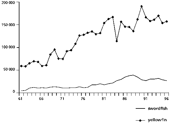
The historical trends of annual catches were used to define fishery time periods for each species. Three time periods were defined for sailfish and white and blue marlin - a first period from 1961 to 1966 during which the catches increased and then decreased as the fishery expanded to the middle of the Atlantic; a second period from 1967 to 1980 during which catches remained low as the abundance of marlins decreased and as the longline fleet switched to deeper longline gear; and a third period from 1981 to 1996 during which catches increased at a slight rate but oscillated considerably (Figure 12). For northern swordfish, the data were divided into three periods as well. The first period from 1961 to 1977 was characterized by low catches; the second period from 1978 to 1985 showed a rapid increase in landings; and the last period from 1986 to 1996 had catch oscillating at high levels. Yellowfin tuna landings showed a generally increasing trend until the mid-1980s. For convenience, the same time periods used for swordfish were used for yellowfin tuna (Figure 13).
Cumulative landings of blue marlin for the Caribbean region have been respectively 24, 17 and 17 percent of Atlantic-wide landings in the three historical periods. Since 1968, therefore, landings from this region have continued to represent roughly one fifth of total Atlantic landings (Table 8). Cumulative landings of white marlin for the Caribbean region have been respectively 12, 14 and 10 percent of Atlantic-wide landings in these periods, suggesting that, in comparison with earlier historical periods, recent landings from this region are a smaller proportion of total Atlantic landings.
Cumulative landings in the Caribbean region from the western sailfish stock have risen from 10 and 14 percent in the first and second time periods to 41 percent for the most recent period 1981-1996, making the Caribbean the area of greatest landings for the western stock.[18] Cumulative landings of swordfish have represented 5 percent of the northern stock catch since the end of the 1960s. Cumulative landings of yellowfin tuna have remained at around 1 percent of total Atlantic landings.
Estimation of landings from within the EEZs of Caribbean countries was done for yellowfin tuna and white marlin to examine the usefulness of the apportioning model (Tables 9 and 10). Estimates were only obtained for the most recent historical period considered, the 1980s and 1990s, to avoid considering years in which the EEZ had not yet been declared. Because Barbados regularly reports catches of yellowfin tuna to FAO and ICCAT, the estimates of catch from within the Barbados EEZ can be used to investigate whether the procedure at least gives the right order of magnitude of catches. Barbados reported to ICCAT and FAO that catches of yellowfin grew from about 50 tonnes in the mid-1980s to 200 tonnes in the mid-1990s. Yearly catch of yellowfin from within the Barbados EEZ was estimated in our analyses at a range of from 30 to 350 tonnes during the period 1986-1996, in the same order of magnitude as the reported landings (Figure 14). For individual years, however, estimated catches can differ from reported catches by a factor of two. This suggests that the procedure may provide order of magnitude of catches, but is likely to fail to provide reliable yearly estimates.
Estimates of yellowfin tuna catch within the EEZs of CARICOM countries for the period 1986-1996 indicate that yearly catches rarely exceed 100 tonnes, with the exception of the Bahamas, Barbados, Guyana and Suriname (Table 9). Total landings of yellowfin tuna reported by CARICOM countries to FAO for the period 1986-1996 were 8 060 tonnes - a similar value to the one calculated by our analysis for the catch obtained from within the EEZs of CARICOM countries: 7 230 tonnes. Estimates of white marlin catch within the EEZs indicate that these catches are highly sporadic and in general are less than 10 tonnes per year for most countries (Table 10).
FIGURE 12
Landings (tonnes) from stocks of western sailfish, white and blue marlin for
the three historical periods defined for the analysis. Sum of landings for the
three stocks is also shown
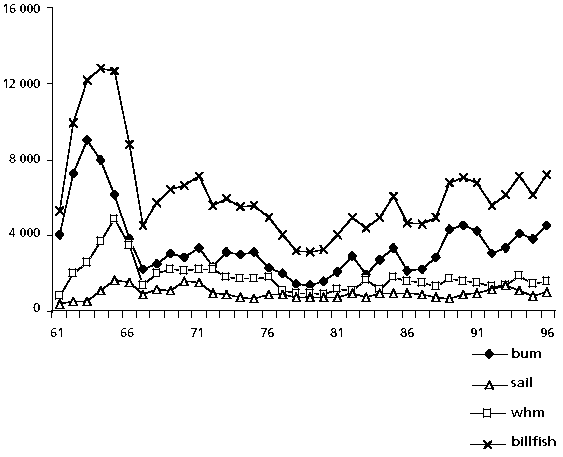
FIGURE 13
Landings (tonnes) of yellowfin tuna and northern swordfish stocks showing the
three historical periods defined for the analysis
These results are highly dependent on the assumptions of the apportioning method and on the reporting of catches to ICCAT. Catches made by CARICOM country vessels and not reported to ICCAT are not considered in the estimation procedure. For countries that do report catch statistics to ICCAT, the method seems to perform well and may be useful in obtaining estimates of harvest from within the EEZs. The results suggest, however, that the current EEZ catch is not several orders of magnitude larger than the reported catch to FAO, but rather similar to the reported catch. This may be explained by hypothesizing that most of the catch is indeed taken by CARICOM countries and not by foreign vessels. However, it is still possible that catch from within the EEZs of CARICOM countries is never reported to ICCAT and therefore will not show in our calculations.
TABLE 8
Percentage of cumulative catches made within the Caribbean and the Gulf of Mexico areas for billfish, swordfish and yellowfin tuna for stocks that occur in the Caribbean for the three historical periods considered in the analysis
| |
1961-1966 |
1967-1980 |
1981-1996 |
|
Caribbean |
|||
|
Blue marlin |
24 |
17 |
17 |
|
White marlin |
12 |
14 |
10 |
|
Sailfish (W) |
11 |
14 |
41 |
|
Swordfish (N) |
2 |
5 |
5 |
|
Yellowfin tuna |
1 |
1 |
1 |
|
Gulf of Mexico |
|||
|
Blue marlin |
4 |
9 |
9 |
|
White marlin |
5 |
8 |
3 |
|
Sailfish (W) |
17 |
28 |
13 |
|
Swordfish (N) |
8 |
2 |
4 |
|
Yellowfin tuna |
<1 |
<1 |
<1 |
Catch distributions by 5-degree grid, quarter and species are shown in the Appendix. Average swordfish quarterly catches for the period 1986-1996 show that a significant portion of catches of the northern stock are made in the southeastern Caribbean. In this area, catches are greater during the first two quarters of the year and on the Atlantic side of the island arch. Catches are low in the last two quarters of the year and in the Caribbean Sea.
Catches of yellowfin tuna for the period 1986-1996 are dominated by those occurring in the eastern central Atlantic. However, there are also high catches in the southern part of the Lesser Antilles and north of Venezuela. In this area catches of yellowfin tuna are common throughout the year, and quarterly distributions do not show significant seasonality.
Sailfish catches for the period 1981-1996 are highly concentrated in a few areas. The main ones for the western stock are the Caribbean and central Brazil. For this stock, northern catches concentrate off southern Florida in the first quarter, east of Hispaniola in the second quarter, in the northwestern Gulf of Mexico in the third quarter and north of Cuba in the fourth. In the Lesser Antilles, the largest catches occur in the second quarter.
During 1981-1996 white marlin catches show large seasonal changes in the spatial distribution. Most catches in the first and fourth quarters occur south of 10°N, whereas the majority of the catches in the second and third quarters occur north of 5°S. In the eastern Caribbean, catches are greatest in the second semester and lowest in the first.
Average quarterly catches of blue marlin for 1981-1996 show large seasonal changes similar to those described for white marlin. In the first quarter, catches are concentrated around the equator and off Brazil. In the second quarter, they mainly occur north of the equator, including east of the Caribbean island arch and in the Gulf of Mexico. In the third quarter, catches come mainly from around the equator and the southern Caribbean, east and west of the island arch. During the fourth quarter, most catches are from around the equator. In the Lesser Antilles, catches occur year round, but are lowest during the fourth quarter.
TABLE 9
Estimated landings (tonnes) of yellowfin tuna within EEZs of CARICOM countries
|
Year |
Antigua and Barbuda |
Bahamas |
Barbados |
Dominica |
Grenada |
Guyana |
Jamaica |
St Kitts and Nevis |
St Lucia |
St Vincent and the Grenadines |
Suriname |
Trinidad and Tobago |
|
86 |
25 |
41 |
75 |
16 |
63 |
52 |
10 |
1 |
13 |
67 |
47 |
54 |
|
87 |
18 |
36 |
61 |
15 |
60 |
86 |
3 |
1 |
12 |
64 |
47 |
50 |
|
88 |
24 |
139 |
59 |
21 |
93 |
95 |
5 |
2 |
18 |
99 |
68 |
71 |
|
89 |
5 |
178 |
37 |
15 |
77 |
63 |
21 |
0 |
15 |
82 |
61 |
56 |
|
90 |
2 |
69 |
219 |
3 |
15 |
82 |
41 |
0 |
8 |
16 |
87 |
57 |
|
91 |
1 |
53 |
279 |
4 |
20 |
150 |
16 |
0 |
10 |
21 |
160 |
72 |
|
92 |
1 |
46 |
281 |
5 |
24 |
108 |
8 |
0 |
11 |
25 |
106 |
75 |
|
93 |
10 |
37 |
335 |
8 |
34 |
140 |
7 |
1 |
14 |
36 |
90 |
93 |
|
94 |
15 |
24 |
164 |
20 |
91 |
65 |
7 |
1 |
20 |
97 |
32 |
91 |
|
95 |
124 |
34 |
262 |
32 |
65 |
161 |
6 |
9 |
18 |
70 |
84 |
97 |
|
96 |
25 |
30 |
62 |
22 |
88 |
57 |
23 |
1 |
17 |
94 |
54 |
67 |
TABLE 10
Estimated landings (tonnes) of white marlin within EEZs of CARICOM countries
|
Year |
Antigua and Barbuda |
Bahamas |
Barbados |
Dominica |
Grenada |
Guyana |
Jamaica |
St Kitts and Nevis |
St Lucia |
St Vincent and the Grenadines |
Suriname |
Trinidad and Tobago |
|
81 |
14 |
3 |
7 |
2 |
0 |
4 |
3 |
1 |
0 |
0 |
6 |
1 |
|
82 |
8 |
3 |
6 |
1 |
1 |
3 |
1 |
0 |
0 |
1 |
5 |
2 |
|
83 |
2 |
8 |
1 |
0 |
1 |
1 |
1 |
0 |
0 |
1 |
1 |
0 |
|
84 |
1 |
10 |
10 |
0 |
1 |
7 |
1 |
0 |
0 |
1 |
12 |
2 |
|
85 |
14 |
10 |
10 |
3 |
2 |
9 |
2 |
1 |
1 |
3 |
17 |
3 |
|
86 |
11 |
20 |
6 |
2 |
1 |
51 |
1 |
1 |
0 |
1 |
30 |
2 |
|
87 |
26 |
10 |
8 |
6 |
7 |
1 |
0 |
2 |
1 |
8 |
2 |
6 |
|
88 |
0 |
46 |
1 |
0 |
0 |
5 |
0 |
0 |
0 |
0 |
4 |
0 |
|
89 |
0 |
16 |
2 |
0 |
0 |
1 |
1 |
|
0 |
0 |
2 |
0 |
|
90 |
0 |
20 |
2 |
0 |
0 |
3 |
0 |
|
0 |
0 |
4 |
1 |
|
91 |
0 |
6 |
1 |
0 |
0 |
1 |
0 |
0 |
0 |
0 |
1 |
0 |
|
92 |
0 |
12 |
2 |
0 |
0 |
2 |
0 |
|
0 |
0 |
2 |
1 |
|
93 |
0 |
10 |
5 |
0 |
0 |
4 |
0 |
|
0 |
0 |
4 |
1 |
|
94 |
1 |
1 |
3 |
0 |
0 |
3 |
0 |
0 |
0 |
0 |
3 |
1 |
|
95 |
27 |
0 |
1 |
4 |
|
0 |
0 |
2 |
0 |
|
0 |
1 |
|
96 |
2 |
1 |
2 |
1 |
2 |
0 |
0 |
0 |
0 |
2 |
0 |
1 |
Fishing effort
The ICCAT data used in this analysis contain nominal effort data. Records represent monthly data by grid on 26 different types of gears and 14 types of effort units. To simplify the task of obtaining a single effort index, the most common gear/effort-type combinations were chosen (Table 11). These combinations represent 86 percent of all effort records and the majority of records for the major gears. Choosing the above records means that some of the data corresponding to the main gears are not used, because they are expressed in other types of fishing-effort unit. The percentage of records ignored is small for all gears except for baitboats, where effort expressed in days fished or hours fished represents 85 percent of all baitboat effort records (Table 12).
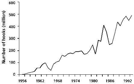
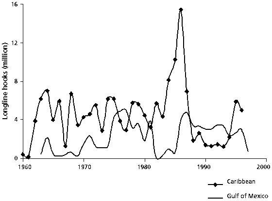
Longline is the only gear for which most of the effort recorded in the ICCAT database is in a single effort unit (number of hooks). The historical pattern estimated from the current analysis (Figure 14) coincides well with that of previous studies (ICCAT, 2001a) and shows a steady increase in the number of hooks used in the Atlantic. The historical pattern for the Caribbean is much more variable, and after a large increase in the early 1980s due to expansion of operations by the US fleet, effort has settled back to the levels present in the 1960s and 1970s (Figure 15). Recent data from the US pelagic longline fleet show that effort in the Caribbean area decreased further for this fleet after 1996.
FIGURE 14
Atlantic-wide longline effort
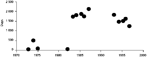
Baitboat effort is reported in a number of different units, and since 1989 a large part of the fleet reports effort in fished hours (Figure 16). As in the case of purse seine, because of the number of effort units used for baitboats, effort trends are difficult to reconcile with patterns published for individual fleets in this study. It was not possible to develop a standard effort unit for baitboat for the entire Atlantic. In any case, baitboats are not a large part of the fishery in the Caribbean, and effort has only been reported in a few years (Figure 17), mainly offshore of Venezuela. There are no reports of baitboat effort in the Gulf of Mexico.
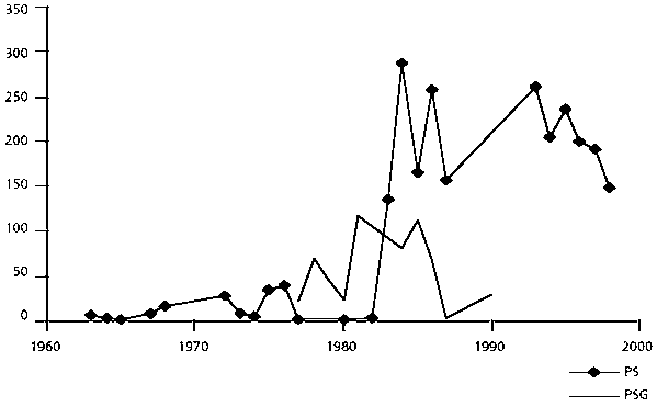
Three major types of purse-seine (PS) gears appear in the ICCAT database: large purse seines (PSG) for vessels with over 200 tonnes capacity, medium purse seiners (PSM) between 50 and 200 tonnes capacity and small purse seiners (PSS) with less than 50 tonnes capacity. Only the first two are considered in this analysis. Fishing effort is always expressed in days fished except for PS, for which since 1991 effort has been expressed in hours fished as well.[19]
Effort patterns for these two gears are highly variable and in the case of PSG have changes in values that are difficult to explain. In 1983 and 1984, effort in days fished for this gear was four times greater than in any of the preceding or following years. Nor is it clear why there is no reported effort of large purse seiners after 1991 (Figure 18).
TABLE 11
Gear and effort-type combinations selected for effort analyses
|
Geara |
Effort type |
Percentb |
|
BB |
DAYS FISHED |
12 |
|
BB |
HOURS FISHED |
1 |
|
LL |
NO. HOOKS |
35 |
|
PS |
DAYS FISHED |
6 |
|
PS |
HOURS FISHED |
6 |
|
PSG |
DAYS FISHED |
19 |
|
PSM |
DAYS FISHED |
7 |
|
Total |
|
86 |
a BB, baitboats; LL, longline; PS, purse seine; PSG, large purse seine; PSM, medium purse seine.
b Percent represents the portion of all records in the ICCAT database associated with each combination.
TABLE 12
Percent of all records for each major gear considered in the analyses
|
Geara |
Percent |
|
BB |
85 |
|
LL |
94 |
|
PS |
94 |
|
PSG |
97 |
|
PSM |
99 |
a BB, baitboats; LL, longline; PS, purse seine; PSG, large purse seine; PSM, medium purse seine.
FIGURE 15
Longline effort in the Caribbean area and Gulf of Mexico
In the Caribbean, purse-seine effort was very low before 1982. Some effort was reported by large purse seiners during 1978-1990, but no effort has been reported since for that category of vessel (Figure 19). Purse-seine effort is presently restricted to the area around Venezuela. It is unclear whether changes in effort reported to ICCAT reflect true changes in the fishery or problems in reporting, including changes in the type of effort units used to report. Thus it does not seem appropriate to use the current ICCAT data to produce a single measure of purse-seine effort.
FIGURE 16
Fishing effort of baitboats for the Atlantica
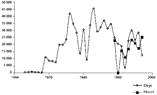
a Since 1989 part of the fleet has begun reporting effort in hours rather than days.
FIGURE 17
Fishing effort of baitboats in the Caribbean
Data available on the spatial dynamics of oceanic species are scant. Most of the information comes from fishery data, because biological studies such as tagging studies are only recently starting to produce average movement patterns and cannot be used to test changes in the migration routes. In the case of the most studied of all tunas, the bluefin, there is evidence of some changes in the distribution of the stock. The Norwegian and Brazilian bluefin-tuna fisheries that produced large catches during the 1960s and 1970s respectively are not producing much now. There is therefore a possibility that the spatial distribution of biomass does change historically.
It is well known that fishing concentrates in the areas of greater abundance and/or availability. This will bias the use of accumulated catch as an index of abundance, so that the relative indices derived from areas of low abundance will be underestimated and those from high abundance will be overestimated. But the spatial distribution of fishing also depends on fishing logistics and regulations. Thus in the early phases of a fishery, only the areas close to port are fished. As the fishery expands, distance to home port tends to be less important. Similarly, as a fishery matures and becomes increasingly regulated, the areas fished may become more independent of abundance. Seasonal catch distributions may reflect seasonal shifts in effort; however, in coastal fisheries effort is likely to be less seasonal, so coastal distribution of catches probably depicts stock availability.
FIGURE 18
Fishing effort (days or hours fished) of purse seiners (PS), between 50 and
200 tonnes, and of large purse seiners (PSG), of more than 200 tonnes, in the
Atlantic
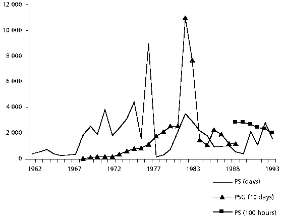
FIGURE 19
Fishing effort (days fished) of purse seiners (PS), between 50 and 200 tonnes,
and of large purse seiners (PSG), of more than 200 tonnes, in the Caribbean
In general, fishing effort is a notoriously difficult measurement to make, because it varies with the type of gear and fishery in the operation of each fleet. Although ICCAT has attempted to standardize the reporting of fishing effort, many countries have historically reported it in their own type of units, thus making it harder to combine data from different fisheries.
Because the spatial data on fishing effort in the ICCAT database have not been thoroughly reviewed, it is difficult to know whether they are reliable enough to be combined with the catch data to produce CPUE estimates. Furthermore, the data contained in the database are summary data and therefore do not strictly contain CPUE observations (for individual vessels or trips), making them less accurate than the data used by scientists in the estimation of abundance indices for individual fisheries. However, it may be possible to combine CPUE databases from a subset of fisheries to develop more Atlantic-wide, spatially-structured abundance indices.
Offshore and coastal pelagic fish are intrinsically difficult to assess because of the large geographical area they occupy and their complex migration dynamics. For most of them, the biological evidence supporting the current stock structure accepted by ICCAT is weak. As a consequence, any spatial assessment of these stocks carries the uncertainty inherent in how the boundaries of the stock are defined. ICCAT has not, to date, been able to develop assessment models that provide indices of stock status at spatial scales smaller than that of a stock. Given the large geographical areas occupied by these stocks, this leads to an inability to determine whether some areas in the Atlantic are more or less important in the management of these stocks, thus curtailing ICCAT’s ability to provide advice that has a spatial or geographical basis. This leads to the adoption of management measures that are applied independently of geography. For example if a stock is overexploited and requires a reduction in catch to recover abundance, catch is required to be reduced in all areas.
It is clear from the number of abundance indices developed for the same stock that abundance does not vary in the same way in all areas occupied by a stock. In fact some stocks disappear in some areas while surviving in others (e.g. the disappearance of bluefin tuna off northern Brazil). Other stocks are abundant in certain areas in some years and in other areas in other years. This suggests that even for offshore pelagic fish, we cannot assume that individuals mix throughout the area of the stock. Regional and local dynamics partially determine local abundance.
The difficulty is that fishers and managers that operate at smaller spatial scales may have very different perceptions of changes in abundance - and therefore of opportunities for development - than those provided by evaluation of the entire stock. This is probably the case with many countries of the Caribbean region, where fleets access the stocks of oceanic fish in a small area. The reality is that we do not have the information and methods to provide indices of abundance at scales smaller than that of a stock. Therefore, and following the precautionary approach, management should be based on the status of the stock evaluated at the scale of the entire stock, and management decisions made at smaller spatial scales must consider such evaluation.
The new bigeye model (Maury and Restrepo, 2001) will be the first test of a model for estimating regional abundance indices for oceanic species occupying the tropics. It is recommended that when this model is fully tested it be adapted to other species, so that stock assessments can provide regional indices of abundance. These indices may then be used in evaluating the relative importance of different areas of the stock and the appropriate management strategies for each area.
The only information presently available to provide CARICOM with a regional view of oceanic resources is the level of catches made within CARICOM waters. As the analysis of FAO and ICCAT landings indicates, for most stocks such catches are a small part of the total catch. For coastal pelagics, and possibly for western sailfish, it seems that Caribbean waters represent a large fraction of the area and presumably the biomass of these stocks. Unfortunately, the FAO analysis has also shown how uncertain these catch estimates are. Given that landings are nowadays the main source of information allowing CARICOM to evaluate the status of oceanic and coastal pelagic stocks within their waters, it is imperative that the uncertainty in landing estimates be reduced. It should be a priority of countries to improve their data-collection systems to reduce this uncertainty as much as possible. Even if methodological initiatives such as Maury and Restrepo (2001) are successful, it is only with accurate data on landings that these new types of models can be scaled-down to provide indices for individual countries.
|
[17] In this analysis, every
effort is made to check the results with other analyses of the ICCAT data made
by ICCAT working groups. Whenever there is a major discrepancy between analyses,
the discrepancy is pointed out in a note. However, it was not the aim of this
project to resolve all discrepancies. [18] This high percentage is driven by the large reported catches of sailfish from Cuba for the period 1991-1994 and for Grenada for the period 1985-1994. Sailfish landings from Cuba in the current analysis do not correspond to those reported in the last ICCAT sailfish assessment (ICCAT, 2001a), which are much lower. [19] Over the years, countries reporting to ICCAT seem to have attempted to change the units used for reporting in order to coincide with the units used by other countries. This seems to have been done by using conversion factors, for example to convert hours fished to days fished for baitboats. The result is that days fished are sometimes expressed in decimal numbers, resulting in a distribution that does not easily lend itself to statistical characterization. Similar results can be seen for other gears, for instance when purse-seine effort is recorded in fished hours, most records are multiples of 12 hours, but many other records are recorded in hours or decimals of hours. Unfortunately, the origin of such records cannot be determined with the database used in this analysis. The data used represent effort aggregated for each 5-degree grid by gear and effort type. Thus a grid with an effort of 55.3 hours fished could be the result of a single record from one country representing 55.3 hours or it could be one record with 48 hours of fishing and another one with 7.3 hours. We cannot therefore assess whether any of those expressed in decimals represent accurate records or not. |
![]()
![]()
![]()