![]()
![]()
![]()
Pakistan is situated between the latitudes of 24° and 37° north and longitudes of 61° to 75° east, stretching over 1 600 kilometres from north to south and 885 kilometres from east to west, with a total area of 796 095 square kilometres. It has a subtropical and semi-arid climate. The annual rainfall ranges from 125 mm in the extreme southern plains to 500 to 900 mm in the sub-mountainous and northern plains. About 70 percent of the total rainfall occurs as heavy downpours in summer from July to September, originating from the summer monsoons, and 30 percent in winter. Summers, except in the mountainous areas, are very hot with a maximum temperature of more than 40 °C, while the minimum temperature in winter is a few degrees above the freezing point.
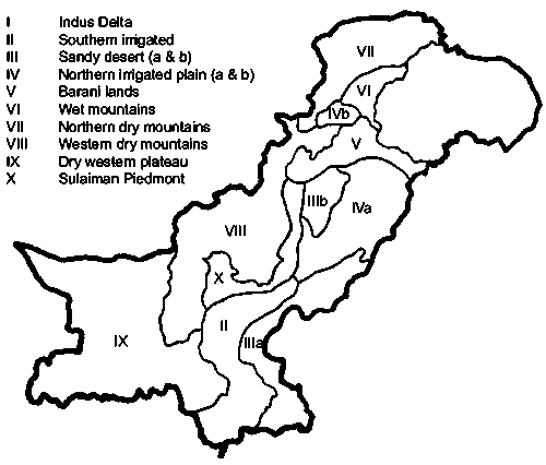
Basically, the country has been divided into ten agro-ecological zones based on physiography, climate, land use and water availability (Figure 1).
Indus Delta. The climate is arid tropical marine. The mean monthly summer rainfall is 75 mm and winter rainfall less than 5 mm. The mean daily temperature is between 34 °C and 40 °C in summer and between 19 °C and 20 °C in winter. The soils are clayey and silty. Rice, sugar cane, banana and pulses are the major crops.
Southern Irrigated Plain, the Lower Indus Plain. The climate is arid and subtropical. The mean monthly summer rainfall is 18 mm in the north and 45 to 55 mm in the south. The soils are silty and sandy loam but the upper areas of the flood plain are calcareous loamy and clayey. Cotton, wheat and sugar cane are grown on the left bank of the Indus and rice, wheat and gram on the right bank.
|
Figure 1
|
Source PARC, 1980
Sandy Desert (a). The maximum rainfall is 300 mm. The soils are sandy and loamy fine sand. The land is used for grazing.
Sandy Desert (b) - sand ridges and dunes. The rainfall is between 300 and 350 mm. The soils are sandy and loamy fine sand. The land is used for grazing.
Northern Irrigated Plain (a) - Flood Plains and Bar Uplands. The climate is semi-arid to arid. The mean annual rainfall is 300 to 500 mm in the east and 200 to 300 mm in the southwest. The soils are sandy, loam-clay and loam. The canal irrigated crops are wheat, rice, sugar cane, oilseed and millets in the north and wheat, cotton, sugar cane, maize, citrus and mangoes in the centre and south.
Northern Irrigated Plain (b) - alluvial valleys of Peshawar and Mardan. The climate is semi-arid. The mean monthly rainfall is 20 to 30 mm. The soils are silty clays and clay loams. The main crops are sugar cane, maize, tobacco, wheat, berseem, sugar beet and orchards.
Barani (rainfed) Lands. This covers the Salt Range and the Potwar Plateau. In the North the mean monthly rainfall is 200 mm in summer and 35 to 50 mm in winter. The climate in the Southern part is semi-arid and hot. The mean monthly rainfall is 85 mm in summer and 30 to 45 mm in winter. The main crops are wheat, millet, oilseed and pulses.
Wet Mountains - High Mountains. The mean monthly rainfall is 235 mm in summer and 116 mm in winter. The soils consist of silt loams to silty clays. A small area is under rainfed agriculture but most of it is under forest.
Northern Dry Mountains. The mean monthly rainfall is 25 to 75 mm in winter and 10 to 20 mm in summer. The valley soils are deep and clayey. Most of the area is used for grazing.
Western Dry Mountains. They are composed of barren hills with steep slopes. The mean monthly rainfall is 95 mm in summer and 63 to 95 mm in winter. The soils in the valleys are deep and loamy. Most of the land is used for grazing. On part of the loamy soils wheat and fruit crops are grown.
Dry Western Plateau - mountainous areas. The mean monthly rainfall is 37 mm in summer. The coastal belt receives a sea breeze. The land is used mainly for grazing. Melons, fruit crops, vegetables and wheat are grown where water is available.
|
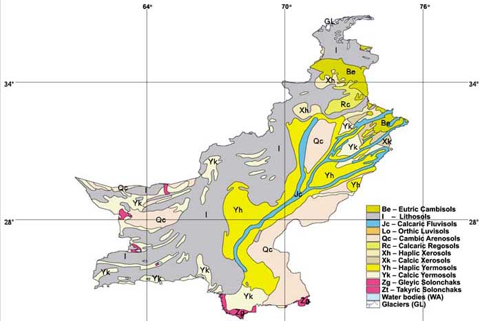
FIGURE 2
|
Source: FAO/UNESCO
Sulaiman Piedmont - plains of the Sulaiman Range. The climate is arid and hot. The mean monthly rainfall is less than 15 mm. Irrigation relies on floods of the hill torrents. Wheat, millet and gram are the main crops.
Figure 2 shows the dominant soils of Pakistan.
The 4 000 year old Indus civilization has its roots in irrigated agriculture. The abandoned creeks of the meandering river, inundated during the flood season, are supposed to have served as the irrigation channels of the ancient systems. The first controlled all-year irrigation began in 1859 with the completion of the Upper Bari Doab Canal emanating from the Madhopur headworks on the Ravi river. The Sukkur barrage, completed in 1932, is considered as the first modern hydraulic structure on the downstream Indus river.
Pakistan can be divided into three hydrological units:
The Indus basin, covering more than 566 000 km² (or 71 percent of the territory), comprising the whole of the provinces of Punjab, Sindh and NWFP as well as the eastern part of Balochistan.
The Karan desert in the west of Balochistan (in the west of the country), which is an endorheic basin covering 15 percent of the territory.
The arid Makran coast along the Arabian Sea covering 14 percent of the territory in its southwestern part (Balochistan province).
Total water withdrawal in 2001 was estimated at 166 km³, of which 95.6 percent for agricultural purposes (4.4 percent is withdrawn for domestic use and another 1.6 percent for industrial use). Groundwater abstraction for agriculture has been roughly estimated at 63 km³/year through more than 500 000 tubewells. However, in some areas, development appears to have reached the point where groundwater is being mined. Most urban and rural water is supplied from groundwater. Over 50 percent of the village water supply is obtained through hand pumps installed by private households. In saline groundwater areas, irrigation canals are the main source of domestic water.
According to the usual Pakistani classification irrigation consists of:
Government canals: 6.38 million ha in 2001/02, of which 58 percent in the Punjab and 29 percent in Sindh province;
private canas: 0.43 million ha, of which 81 percent are in NWFP;
tubewells: 3.45 million ha, of which 82 percent are in Punjab province;
open wells: 0.2 million ha, of which 55 percent are in Punjab province;
canals and tubewells: 7.24 million ha, all of them in Punjab province;
other means: 0.18 million ha.
The total irrigated area is 18 million ha. About 4 million ha is rainfed. The main irrigated crops are wheat, rice, sugar cane and cotton. Owing to inadequate water availability in winter (storage capacity is too small) and at the beginning and end of summer, cropping intensity is exceptionally low. According to a World Bank report, Pakistan does not have enough reservoir capacity in its irrigation system to store seasonal waters.
According to the Soil Survey of Pakistan (Mian and Javed, 1993), 2.8 million hectares of irrigated land is affected by salinity ranging from patchy salinity to dense saline sodic soils.
There are over five million farms in the country. Most of these farms are small (81 percent below five ha), accounting for 39 percent of the farmed area. Seven percent of the farms have over 20 ha but occupy 40 percent of the land (Table 1).
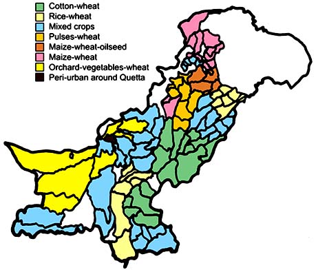
The farming systems depend on the land types, micro climate, availability of irrigation water, market access, population density, transport infrastructure and cultural aspects. Most farms are mixed. Farmers in the crop production regions, whether small or large, produce not only the major crops but also minor crops, vegetables and fruits. They have shade trees for fuel or timber; keep cattle or buffaloes for milk, and own goat/sheep and chickens. Livestock may provide a substantial proportion of the income. There are fifteen crop production regions (CPRs), grouped according to their major cropping patterns. There are five in Punjab, three in Sindh, three in NWFP and four in Balochistan (Figure 3). Details are given in Table 2.
TABLE 1
Farm sizes and areas in Pakistan
|
Size of |
Percent of |
Farmed |
|
< 5 ha |
81 |
39 |
|
5 - 10 ha |
12 |
22 |
|
> 20 |
7 |
40 |
Source: Agriculture Statistics of Pakistan, 2002.
TABLE 2
Crop production regions in
Pakistan
|
No. |
Region |
Cropping pattern |
Agricultural |
Source of |
Rainfall mm |
|
|
|
|
|
|
|
Average |
Range |
|
1. |
Punjab I |
Cotton-wheat |
5.5 |
Canal, tubewell |
156 |
55-247 |
|
2. |
Punjab II |
Rice-wheat |
2.8 |
Canal, tubewell |
800 |
600-1 100 |
|
3. |
Punjab III |
Mixed crops |
4.1 |
Canal, tubewell |
446 |
240-688 |
|
4. |
Punjab IV |
Pulses-wheat |
1.9 |
Canal, rainfed |
300 |
200-550 |
|
5. |
Punjab V |
Maize/wheat-oilseeds |
1.2 |
Rainfed |
900 |
700-1 200 |
|
6. |
Sindh I |
Cotton-wheat |
1.6 |
Canal |
50 |
43-70 |
|
7. |
Sindh II |
Rice-wheat |
1.1 |
Canal |
58 |
40-78 |
|
8. |
Sindh III |
Mixed crops |
1.3 |
Canal, dry |
123 |
62-200 |
|
9. |
NWFP I |
Maize-wheat |
0.9 |
Rainfed |
1050 |
240-1700 |
|
10. |
NWFP II |
Mixed crops |
0.53 |
Canal |
520 |
400-670 |
|
11. |
NWFP III |
Pulses-wheat |
0.36 |
Canal, dry |
500 |
300-600 |
|
12. |
Balochistan I |
Mixed crops |
0.40 |
Tubewell, Karez |
180 |
65-3405 |
|
13. |
Balochistan II |
Orchards/vegetables-wheat |
0.30 |
Tubewell, Karez |
115 |
27-290 |
|
14. |
Balochistan III |
Rice-wheat |
0.35 |
Canal |
- |
- |
|
15. |
Balochistan IV |
Peri-urban |
0.02 |
Tubewell, Karez |
167 |
167 |
Note: Karez = underground water tunnel.
|
FIGURE 3
|
Source: NFDC.
![]()
![]()
![]()