![]()
![]()
![]()
The impacts of towed fishing gears are investigated by comparing physical and biological parameters between sites exposed to experimental trawling and undisturbed control sites, or between commercial fishing grounds that are heavily and those that are lightly fished.
The effects of trawl fisheries on benthic habitats and communities are investigated by determining changes in physical characteristics and community structure after applied fishing disturbance. Two approaches have been applied to demonstrate such changes. One is to conduct experimental trawling on a site and compare the physical and biological parameters at this site before and after the disturbance and/or with an undisturbed control site (Figure 1). The other approach is based on historical data on effort levels in the commercial fishery and comparison between fishing grounds that are heavily fished and areas that are lightly fished or not fished at all.
Experimental trawling provides exact data on the disturbance regime and ensures that biological sampling is taken from the disturbed site. However, this approach does not replicate the spatial and temporal scale of real fisheries.
The former method (experimental trawling) provides exact data on the disturbance regime, i.e. the intensity and number of periods of trawling disturbance, and makes it possible to study a given intensity of trawling or even to design a study that determines the effects of different levels of trawling intensity (e.g. Eleftheriou and Robertson, 1992; Kaiser et al., 1998; Tuck et al., 1998; Prena et al., 1999; Sanchez et al., 2000).
This method also gives exact information on the location and width of the disturbance zone, and modern navigation and positioning systems make it possible to ensure that the benthic samples have been taken in the path of the trawl, although assigning samples to specific components of the trawl (e.g. trawl doors versus ground gear) is difficult. This is the most widely used method, and adopting this approach ensures that the benthic samples are taken from a disturbed site with a given level of disturbance.
The main problem with this approach is that the temporal and spatial aspects of experimental trawling do not truly reflect the large-scale and long-term disturbances that occur in real fisheries (Kaiser et al., 2000; Jennings et al., 2001). In nearly all studies where this approach has been applied, the experimental trawling has been conducted along narrow corridors (but see Currie and Parry, 1996). Individuals of mobile species that are subjected to trawling disturbance may migrate into or out of the disturbed zone.
|
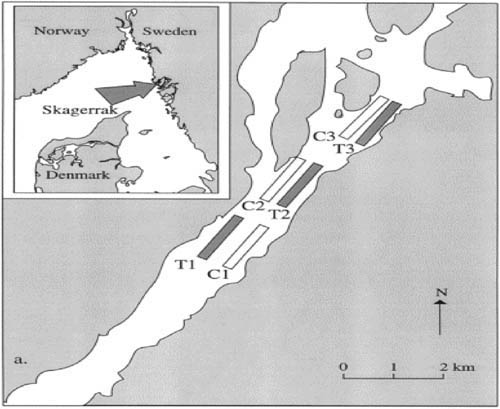
FIGURE 1
Three trawled and three control sites were compared (a). Samples were taken over a four-month period prior to experimental trawling and for four months after the trawling period (b). Source: Redrawn after Lindegarth et al., 2000b. |
Compared with a commercial fishing ground, a narrow disturbance zone may also be more affected by scavengers that emigrate from the surrounding area to feed on prey that has been damaged or exposed on the sea bed by the trawling activity (see Kaiser and Spencer, 1994; Ramsay, Kaiser and Hughes, 1998). Furthermore, experimental trawling is normally completed within a short period of a few hours or days, and only in a few studies was the trawling operation repeated regularly over a period of several months to one year (Tuck et al., 1998; Hansson et al., 2000; Lindegarth et al., 2000a). Although commercial trawlers may fish on a fishing ground for only a short period (as in experimental trawling), most areas fished by trawl are subjected to repeated fishing activity through successive seasons. Therefore most studies using this approach show only the immediate effects of short-term trawling. Some studies, however, also included sampling over a longer period after the trawling disturbance to assess the recovery of affected biota (Van Dolah, Wendt and Nicholson, 1987; Currie and Parry, 1996; Kaiser et al., 1998; Tuck et al., 1998; Kenchington et al., 2001).
Impact studies based on historical effort data reflect disturbances imposed by commercial fishing, but the actual intensity of disturbance is not know and suitable control sites seldom exist.
Impact studies based on historical data from commercial trawling effort do not have these shortcomings. Benthic samples taken from traditional fishing grounds should reflect the disturbance imposed by commercial fishing. However, effort data do not give a detailed description of the spatial distribution of trawling disturbance, because such data are grouped in blocks of relatively large statistical areas. In the North Sea for example, trawling data are collected by the International Council for the Exploration of the Sea's (ICES') statistical rectangles (0.5º latitude x 1º longitude, i.e. about 3 500 km²), and trawling effort is shown to be very patchy within these large blocks (Rijnsdorp et al., 1998). The beam trawl efforts within a 1 442 km² block in the North Sea were shown to vary by a 27-fold range among smaller grids of 103 km² (Jennings et al., 2001).
Thus the actual level of trawling disturbance in the areas sampled is not known in studies that use historical effort data because there will be patches of low effort within high-effort rectangles, and vice versa. In addition, various trawl types are used in commercial fisheries, and the type and configuration of the gear that may have caused trawling disturbance are therefore also unknown. For example, the impacts demonstrated in studies conducted in the Irish Sea and the Georges Bank could have been caused by disturbance from scallop dredges, beam trawls, otter trawls or a combination of these (see Auster et al., 1996; Kaiser et al., 1996; 2000; Collie, Escanero and Valentine, 1997; Collie et al., 2000; Hill et al., 1999). Another weakness of studies based on historical effort data is that neighbouring untouched areas that are suitable as control sites seldom exist (see following section) (but see Van Dolah, Wendt and Levisen.,1991; Simboura et al, 1998; McConnaughey, Mier and Dew, 2000; Smith, Papadopoulou and Diliberto, 2000), and comparison with reference samples taken prior to any commercial fishing activity (if available) may introduce confounding effects owing to natural long-term changes in community structure (Frid, Clark and Hall, 1999; Hill et al., 1999). The properties of impact studies based on experimental trawling and historical data are summarized in Table 1.
TABLE 1
Advantages and disadvantages of the experimental
trawling and historical data approaches used to investigate the impacts of towed
fishing gears
|
Properties |
Experimental trawling |
Historical data |
|
Data on disturbance regime |
Yes |
No |
|
Exact location and size of disturbed area |
Yes |
No |
|
Description of gear type |
Yes |
Seldom |
|
Reflect commercial fisheries |
No |
Yes |
|
Suitable control sites |
Often |
Seldom |
|
Affected by migration of mobile species |
Yes |
No |
Experiments without replication at the appropriate spatial scale run the risk of overestimating the effects of trawling disturbance. The most serious shortcoming in impact studies may therefore be the confounding of effects owing to lack of replicate control sites.
Studying the effects of mobile fishing gear on benthic communities involves comparing ecological parameters before and after trawling and/or between disturbed (trawled) and undisturbed (control) sites (Figure 1). As the abundance of benthic organisms may change naturally, to test hypotheses about the impacts of fishing activities it is necessary to compare the magnitude of temporal changes in fished areas with changes in an undisturbed control area (Stewart-Oaten, Murdoch and Parker, 1986; Underwood, 1992; Lindegarth et al., 2000b).
Several experiments on trawling disturbance have involved comparison between a single treatment site and a single control site (e.g. Van Dolah, Wendt and Levisen, 1991; Currie and Parry, 1996; Tuck et al., 1998; Frid, Clark and Hall, 1999). This experimental design lacks independent replicates of the treatments, and is therefore only suitable to demonstrate differences between locations (Hurlbert, 1984). Differences in temporal changes found between the disturbed (trawled) site and the control site during these studies have been interpreted as the effects of trawling. Such conclusions cannot, however, be justified unless more than one control site is monitored (Underwood, 1992; Lindegarth et al., 2000b).
Experiments without replication at the appropriate spatial scale are spatially confused, and run the risk of overestimating the effects of physical disturbance (Hansson et al., 2000; Drabsch, Tanner and Connell, 2001). Furthermore, in order to evaluate the severity of the effects of trawling, the magnitude of the effects should be related to natural temporal and spatial variability in the ecological parameters analysed, and to the effects caused by natural disturbances such as wave action and strong currents. Such comparisons also require replicates at appropriate temporal and spatial scales.
Lindegarth et al. (2000b) used data from an experiment involving three pairs of disturbed and control sites to explore the problem of interpreting results from experiments using a single treatment and control site. This was achieved by comparing conclusions from analyses of the whole experiment (i.e. all six sites) with those of analyses based on pairs of sites (see Figure 1). Analyses based on the whole experiment did not reveal changes that could be attributed to trawling disturbance, whereas analyses of pairs of sites showed a large number of significant differences, both between pairs of trawled and control sites and between pairs of control sites. The authors concluded that the impacts of trawling could not have been assessed in a useful way had this experiment involved only one trawled and one control site. They also stated that insufficient replication has potentially large consequences on the interpretation of other experiments, although experiments on the short-term effects of disturbance may be less affected by this type of confounding. The most serious and widespread shortcoming in impact studies may thus be confounding effects owing to a lack of replicate control sites.
This confounding problem is caused by natural temporal and spatial variability in benthic communities, and the control area should therefore resemble as closely as possible the disturbed area in terms of depth, current conditions, sediment type and benthic assemblage. However, potential control areas are often unfished precisely because they differ from real fishing grounds, thus interpretation may be difficult. Fortunately there are exceptions where areas have been closed to fishing for military reasons, to protect juveniles and non-target species, or to rebuild depleted stocks (Tuck et al., 1998; Prena et al., 1999; Lindegarth et al., 2000a; Drabsch, Tanner and Connell, 2001; Kutti et al., in press). Comparing disturbed and control sites within such closed areas would be the ideal situation for the experimental trawling approach.
Some studies adopted the approach of using wreck sites as control areas based on the fact that trawlers are likely to avoid fishing in the close vicinity of shipwrecks because such obstacles can cause gear damage (Hall et al., 1993; Ball, Fox and Munday, 2000; Pranovi et al., 2000). Although the benthic community nearest to a wreck should therefore be in a relatively undisturbed state, these sites may act as artificial reefs. The comprehensive literature on the effects of artificial reef habitats on community structures and fish assemblages clearly demonstrates that the benthic fauna of wreck sites differs from that of surrounding areas (Bohnsack and Sutherland, 1985; Seaman and Sprague, 1991).
Interpretation of results from studies using the wreck approach is therefore difficult owing to the likelihood of confounding effects associated with the wreck itself. An additional flaw in studies adopting the wreck approach is the lack of fishing effort data at a sufficiently high level of spatial resolution from the area surrounding the wreck (Hall et al., 1993). Thus, when effects cannot be detected, no conclusion can be drawn about the effects of fishing and, on the other hand, when effects are demonstrated, they cannot conclusively be related to fishing disturbance.
Studies that do not use sea bed classification tools of different spatial resolution run the risk of comparing sites with natural variability in community structure, which could be misinterpreted as trawling impacts.
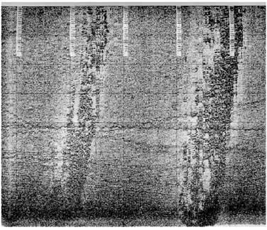
In order to identify appropriate areas for an impact study and to ensure that the disturbed and control sites are of similar habitat type, proper methods and tools are needed. Many devices for bottom classification and identification are available, and the performance of several of these tools is evaluated by Humborstad et al,. 2004. The authors concluded that single tools, which are used in most studies, cannot provide a decisive basis for locating appropriate experimental sites. They suggest applying an acoustic sea bed classification system (e.g. RoxAnn) for broad-scale and rapid mapping, a medium-scale tool (side-scan sonar) for identifying smaller topographic relief (Figure 2) and fine-scale observation (video camera, sledge or grab) for ground truthing and detailing the characterization of sediment type. Studies that do not use several tools for bottom characterization do not provide a proper description of the area studied, and run the risk of comparing sites with natural variability in community structure, which could be misinterpreted as trawling impacts.
|
Figure 2
|
This combination of observation platforms of different spatial resolution also provides valuable data for assessing the physical impacts of trawling (Humborstad et al., 2004). The acoustic bottom classification system RoxAnn provides real-time characterization of the sea bed based on its hardness and roughness.
This system has been used in several impact studies (e.g. Kaiser and Spencer, 1996; Schwinghamer et al., 1998; Tuck et al., 1998; Humborstad et al., 2004), but its performance for sea bed mapping and classification has been reported to be relatively crude (Greenstreet et al., 1997; Hamilton, Mulhearn and Poeckert, 1999). Schwinghamer, Guigné and Siu (1996) used a sophisticated method based on high resolution and broadband acoustics to determine trawl disturbance on the small-scale structural properties of the upper 4.5 cm of bottom sediments.
Side-scan sonars have been widely used to demonstrate physical disturbances caused by trawling (e.g. Schwinghamer et al., 1998; Thrush et al., 1998; Tuck et al., 1998; Humborstad et al., 2004). Trawl doors create furrows in muddy and sandy sediments that are readily seen on side-scan sonograms. Although marks made by ground gear have been observed by this method (Humborstad et al., 2004), only relatively deep (several centimetres) furrows and marks can be recognized from side-scan recordings, owing to their limited resolution. This method is therefore suitable mainly to demonstrate the extent and longevity of the physical disturbances caused by heavy gears such as trawl doors, large dredges and beam trawls. Friedlander et al. (1999) demonstrated that side-scan images also present a promising independent approach for identifying the location of trawling activity and for evaluating fishing effort on a spatial scale that is consistent with commercial fishing activities.
Underwater cameras may provide more detailed observations to demonstrate physical disturbances from small trawls or the lighter parts of a gear that do not cause deep furrows. Marks on the sea bed made by trawl doors, wires, ground ropes and nets were evident from video observations in the Mediterranean (Smith, Papadopoulou and Diliberto, 2000). Fresh and older marks could be differentiated from the shape of their edges and their colour. Evidence of the resuspension of sediments, i.e. turbidity clouds, was also obtained from these observations. Freese et al. (1999) used video observations to quantify the proportion of boulders displaced by the ground rope. Thus, the use of underwater cameras may provide valuable observations on how different parts of the trawl interact with the sea bed.
Grabs and cores provide quantitative samples, but are not suitable for patchy distributed fauna of low abundance. The semi-quantitative dredge sampling method has been improved specifically for the purposes of impact studies. Cameras are the only sampling method used on rough bottoms (cobbles, boulders).
Five different types of device have been used to sample benthic fauna for assessing the biological impacts of trawling disturbance: grab, corer, dredge, beam trawl and camera. Grabs and corers are appropriate sampling tools for bottom sediments ranging from mud and silt to coarse sand and small stones (pebbles), but not for hard-packed sandy bottoms or coarse bottoms with cobbles. Grab and core sampling is the most quantitative method, as the size of the area sampled is determined by their opening and thus can be identified very accurately. These two sampling methods have been used in most of the impact studies carried out to date. However, large numbers of samples are required, as the area sampled is small, e.g. 0.07 m² for boxcorers, 0.2 m² for van Veen grabs, and occasionally up to 0.5 m² for large grabs (Bergman and van Santbrink, 1994; Kenchington et al., 2001). Consequently, these methods are not suitable for sampling benthic fauna with patchy distribution and low abundance.
A video-equipped hydraulic grab has been specially designed for sampling offshore dense sand sea beds (Schwinghamer, Guigné and Siu, 1996; Kenchington et al., 2001). This grab is lowered gently to rest on the sediment, and the jaws are then closed hydraulically under video observation. In order to assess the impacts on both infaunal species and more sparsely distributed epibenthic species, grabs have been used in combination with dredges in several studies (Simboura et al., 1998; Currie and Parry, 1999; Prena et al., 1999; Kenchington et al., 2001).
Dredges and beam trawls, which can be used on similar bottom types as grabs and corers, are more appropriate for estimating the densities of low-abundance benthic species because they cover much larger areas (up to several hundred square metres). Most types of these sampling gears are, at best, semi-quantitative owing to the problem of estimating the area sampled accurately (Holme and McIntyre, 1984).
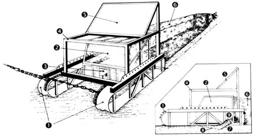
The dredge sampling method has undergone several modifications to overcome the problem of determining the time that the gear is in contact with the bottom and the length of the tow, e.g. the odometer wheel (Prena et al., 1999) and combining integrated trawl instrumentation (ITI) positioning data and video observations (Kutti et al., in press). In addition, quantitative dredges have been developed for the specific purpose of trawl impact studies (Figure 3; Bergman and van Santbrink, 1994; Prena et al., 1999).
|
FIGURE 3
|
Sampling by dredges can be further improved through monitoring the performance of the sledge hauls with a video camera (Prena et al., 1999; Kutti et al., in press). With this improvement, the sampling of rougher bottom is possible because tows of dubious quality can be aborted and repeated (Humborstad et al., 2004).
Observations from video and photo cameras are the only method that has been used to sample coarse sea beds of cobbles and boulders. However, the type and size of organisms that can be studied using this method are very limited.
Only those species that are easily visible and identifiable on photographs or a video monitor (e.g. > 5 cm and > 20 cm in size, respectively) could be quantified for statistical analyses in the studies by Freese et al. (1999) and Moran and Stephenson (2000). Even the identification of species of large organisms (e.g. sponges) may be problematic from camera images. Quantitative analyses based on this sampling technique require reference points to determine the width of the camera image, i.e. the size of the area sampled (see Thrush et al., 1998; Freese et al., 1999; Moran and Stephenson, 2000). Sampling based on camera observations has the advantage that visible marks made by the gear ensure that the samples are taken within the trawl path and not in untouched corridors between adjacent paths.
Studies using grab, core, dredge or beam trawl require accurate positioning of the sampling device. In studies based on disturbance from experimental trawling, the corridors trawled are often very narrow (100 to 200 m) and there is a risk of sampling outside the disturbed area. In particular when operating in deep water and under strong currents, accurate positioning of the sampling tool is crucial. Accurate positioning of the trawl is also of great importance, because the position of the trawl relative to the vessel has been shown to vary greatly among and even within trawl hauls (Engås et al., 2000).
In studies where the disturbed area is trawled several times, positioning of the trawl is needed in order to determine the level of disturbance. Different types of systems have been applied to provide positioning data for sampling devices and trawls (e.g. Prena et al., 1999; Humborstad et al., 2004).
![]()
![]()
![]()