![]()
![]()
![]()
E. Schmidt-Kallert
Einhard Schmidt-Kallert, Senior
Consultant in Sociology and Regional Planning with AHT Group AG, Essen,
Germany
In recent years, there has been a resurgence of regionalism and regional development strategies in many countries across Europe. There is an intensive debate on the specific functions of regions in a globalizing world, and policy-makers and strategic planners have rediscovered the region as an important spatial unit located between the local and the national levels that can provide an essential link between local stakeholders and national and transnational networks.
This article describes the characteristics and functions of microregional planning as well as typical phases in the planning process, including the elaboration of project profiles and action plans. It is intended for people of different professional backgrounds working in rural areas and involved in microregional planning processes. Some of them may be local stakeholders; others may be facilitators in a planning exercise.
INTRODUCTION
Rural areas worldwide face manifold problems, including outdated production techniques in agriculture, a scarcity of grazing land, a lack of access to drinking-water, inadequate education options, poor healthcare, a lack of land titles, legal uncertainty and low participation in decision-making. In most cases, there are clear-cut disparities between large cities and rural areas. Rural development has been on the agenda for many years and numerous approaches have been pursued to come to terms with the urban-rural divide.
In most rural areas there are many individuals who can play a meaningful role in improving the economic and social well-being of their area. There are technical specialists who have been posted to a remote part of their country by their government, such as foresters, irrigation engineers, agricultural extension agents. There are local politicians, activists belonging to non-governmental organizations, members of farmers' associations and other civil society organizations (CSOs); there are business people and ordinary citizens. All of them may be interested in bringing about improvements to the area.
Unfortunately, sectoral experts tend to look at rural problems with a bias towards their specific field of interest. Foresters tend to be more interested in forests than anything else; irrigation engineers tend to look mostly at irrigation canals; teachers are more concerned with the education of the young population than with the well-being of the elderly. Politicians and CSO representatives have their own bias.
But sectoral approaches are not enough to resolve the multifaceted problems of the rural population in a holistic manner.
Microregional planning has been practised in many parts of the world, in countries as diverse as Ghana, Hungary, Indonesia and Malawi. It has a longer tradition in countries such as Austria, Germany, the Netherlands and Switzerland, but there are also some very good experiences from African, Asian and Latin American countries. Outside observers witnessing a planning workshop in countries as diverse as Guatemala and the United Republic of Tanzania may be surprised to hear villagers talk about their future in a similar way to village groups in, for example, northwestern Germany. This article is based on experiences from many different parts of the world. For those who want to bring about improvements in a small rural area, it is always useful to share experiences with others in a similar situation.
Over the last decade, regional development and microregional planning have also reached Central and Eastern Europe. In these countries, planning has a negative connotation for many people. Planning reminds them of the central planning machinery that was in place during the socialist period. The planning process outlined in this article, however, is deeply rooted in democracy and participation by ordinary people.
WHY MICROREGIONAL PLANNING?
We have already mentioned that rural development should be multisectoral and holistic in character. A region is a complex fabric with a large number of interrelated problems that can be solved only by an integrated approach.
There is another reason for microregional planning, related to global trends. Throughout the world, global networks are shaping the development opportunities of rural people. These networks tend to be hierarchical in character. International and global cities are linked to the national capitals; the national capitals establish links with the lower tiers in the hierarchy such as secondary and tertiary centres (small towns). The villages are the smallest settlements and are linked in terms of trade and communication to the nearest small town and, to a much lesser extent, to the neighbouring village.
In contrast, horizontal networks can develop within small regions and help improve living conditions for people in rural areas. This could be a network of localized trade links among neighbouring villages, for example exchanges of commodities, information and innovation. In remote areas, a small region is much stronger than villages that try to develop on their own. One village may have assets that another lacks, and villages may complement one another through their different potentials.
WHAT IS MICROREGIONAL PLANNING?
The term regional rural development has been in use for the last 25 years. This term refers to a coherent spatial unit that is located between the local and the national level. The "microregion" is usually much smaller than conventional planning regions.
|
A microregion is a distinct territorial unit with clearly marked boundaries below the regional level, but above the village level. The microregion may be:
|
Planning for one's future - setting goals for the future and deciding on the steps that help to attain these goals - is part of our daily life. Individuals, families, businesses and government departments all plan their activities.
|
Microregional planning attempts to coordinate the planning activities of the numerous actors within a limited territorial unit. It deals with:
|
Above all, microregional planning is about the people who live in the area. People as individuals, as households, people in enterprises and in organizations and institutions. These people have a past, a present and a future in their area. The people have their dreams, their aspirations, their values and their goals.
Obviously, in the course of a planning process, not every actor can attain his or her individual goals to the fullest. There are differences of interest, sometimes clashes, and there is a need for compromise. Very often planners have to mediate between the interests of different actors - they have to find a good compromise that serves the interests of a number of different groups.
CHARACTERISTICS OF GOOD MICROREGIONAL PLANNING
Good planning is:
bottom up, i.e. it is initiated by the local people or their representatives. If a government body such as a planning board or a land consolidation agency initiates planning, there must be a mandate from the local people;
participatory, i.e. all important stakeholders within the area have a say in the elaboration of the plan and are continuously consulted;
action-oriented, i.e. there must be a close link between planning and implementation; a step-by-step approach to complex development; and a package of projects that can be implemented immediately.
Bottom-up, target group participation and action orientation are essential requirements in terms of process management. Three more important elements of the conceptual orientation of microregional planning need mentioning:
development of endogenous potentials;
orientation towards sustainability;
linking land-use planning and land management.
WHAT IS THE ROLE OF PROFESSIONAL PLANNERS?
Professionals can play an important role in initiating the process of microregional planning. "Professional" in this context refers to any technical specialist who plays a mobilizing role and pursues a multisectoral approach. He or she need not necessarily hold a degree in urban and regional planning.
Three points are noteworthy:
Professional planners may play a useful role, but they are not the owners of the process.
Planners act as catalysts that set the planning process in motion.
In addition, planners ensure continuous communication among the planning team, decision-makers and the target group.
TYPICAL PHASES OF THE PLANNING PROCESS
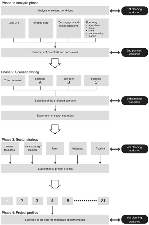
Microregional planning is usually organized in a typical sequence of distinct phases and practical steps. Figure 1 depicts the ideal steps of a microregional planning process. The stages and practical steps form a logical sequence that proceeds in the same chronological order. The main phases are:
analysis;
scenario writing;
elaboration of development strategy and sector strategies;
elaboration of project profiles.
The planning process is followed by the implementation stage and the monitoring and continuous revision of the microregional plan. The planning practice necessitates feedback among the stages and a review of the work accomplished in the previous steps. During this process, new information may arise that requires modification of the goals that were initially set, or elaboration of later phases (for example reformulation of a mid-term development strategy) may require an additional inventory of the current situation to be conducted.
It is of the utmost importance for the local stakeholders to be involved in all phases of the planning process.
ANALYSIS PHASE
In order to be able to plan for the future development of a small region, the point of departure is obviously a solid understanding of the current situation, its problems, its potentials and its opportunities.
However, the analysis phase of a microregional planning study is not a geographical handbook of the area. The analysis of the current situation does not need to be conducted with encyclopaedic goals in mind. Data on issues that are of secondary importance in the particular microregion or that are not necessary for the planning process do not need to be collected or analysed. The inventory of the current situation should focus from the start on the most pressing problems and needs of the local people.
|
|
FIGURE 1
Main phases of the microregional
planning process
Therefore, it can be helpful to hold a workshop at the outset that serves to familiarize the planning team with the definition and perception of the problem as seen by the local population and local decision-makers. Even before the planning team begins its own field investigations, this workshop should be held with decision-makers and representatives from the relevant interest groups.
Usually, the most important sectors for analysis are:
demography and social conditions;
the economy, broken down into agriculture, forestry, manufacturing and tourism;
infrastructure;
land use.
When analysing the results of the inventory of the current situation, care should be taken to go beyond a purely descriptive presentation and to analyse the particular features of the region, for example, to make comparisons with neighbouring regions.
The last step of the analysis phase involves the synthesis of the situation analysis. For this purpose, another workshop with the local stakeholders should be held. The planning team must now decide which they consider to be the most important potentials and problems of the microregion. This can be done in a very simple way by writing the important points on a flip chart. The findings of the planning team should then be compared with the local stakeholders' own views. This step of the analysis phase forms the basis for all future development.
A region's potentials and problems must also be presented in terms of its spatial dimensions, i.e. in map form. Geographic information systems allow the overlay of different thematic maps in such a way that the accumulation of the various favourable and unfavourable sectors at a particular place becomes clearer.
SCENARIO WRITING
This phase deals with projections - forecasting from the existing situation into the future. A particularly useful approach is the scenario method, which is a qualitative and holistic method of forecasting.
The time frames for the projections and for planning should agree with one another. In the past, most regional planning studies set a planning time frame of 20 years. In recent years, the emphasis has shifted to shorter-term programmes and project packages that are easier to implement. As a result, a planning time frame of five years (for short-term action plans) or ten years (medium-term) is usually advocated. This may be justified for a short-term action plan.
However, microregional planning should not completely ignore the longer-term view. Scenario planning in particular requires a clear and recognizable difference between the current situation and the end state depicted in the scenario. A time horizon of 20 years is recommended for scenario planning.
The scenario method is a qualitative forecasting attempt in which the emphasis is placed on describing the interdependence between individual phenomena and sectors. It describes a complex end state, i.e. the imaginable conditions in the target year (e.g. 20 years from now). Scenarios should be based on a clear analysis of the potentials and constraints of the current situation. The conditions described in the scenarios must be attainable with the known technical and organizational tools and with the potential of the land in the microregion.
Scenarios should also be formulated in their spatial dimension. Each scenario relates to a specific land use concept, a specific distribution of settlements, central places and infrastructure. If possible, a map should accompany each scenario.
At the end of this phase, a decision must be taken on the preferred scenario. This is a very important juncture, as it gives legitimacy to all subsequent steps in the planning process. Therefore, the planning team should present the alternative scenarios at a further stakeholder workshop and invite the participants to select the preferred scenario.
ELABORATION OF DEVELOPMENT STRATEGY
This phase describes the route that must be taken to reach the end state outlined in the preferred scenario. The strategy must determine the required specific measures, their temporal sequence and the respective actors (i.e. the people who are responsible for certain measures).
However, there is usually more than one route to the same goal or the same desired end state. Therefore, it may be appropriate to describe several possible development strategies. This should be done at least in a draft form.
It is recommended that the development strategy be broken down into sector-specific strategies for the main development sectors, such as
agriculture
agroprocessing
manufacture
crafts
social development
infrastructure
Each sector strategy first defines the respective development goals (in line with the selected preferred scenario) and sets overall priorities for the sector. Based on these priorities, subprogrammes with a set of more detailed activities or measures are identified. Care must be taken to select project activities that are expected to help in the attainment of the goals set for each sector.
|
Typical structure of a sector strategy:
|
Indicators will allow the results and impacts of planned development to be evaluated. The result indicators refer to the output of project implementation; the impact indicators refer to the wider and more complex effects of development on the social, economic and natural environment.
The fundamental elements of the spatial development strategy are land use, settlement pattern, important corridors of infrastructure, population distribution and distribution of manufacturing jobs.
Formulating a good development programme is not easy given that microregional development is the sum of innumerable actors' actions. The decisions of government officials should be considered as well as the numerous daily decisions of the individuals who live and work in the area - from the decision of where to live or the choice of transportation, to the question of in which market a resident of a rural settlement should buy or sell his or her goods. Ideally, all these actions need to be forecast in a development strategy. In practice, the planner must concentrate on certain key elements.
Having developed the strategy, the planner should crosscheck whether the proposed development path strikes a balance between short-term and long-term goals and the interests of the most important actors within the microregion. The so-called "triple-win approach" may help in this crosscheck.
This triple-win approach links three development objectives:
economy
positive environmental impacts
sound institutions
The triple-win approach does not aim at the maximum, but at the optimum. Triple win means compromising among these three objectives.
ELABORATION OF PROJECT PROFILES AND ACTION PLAN
This phase of the process is especially important because it bridges planning and implementation activities. In order to initiate rural development programmes started, the long-term scenario and the medium-term strategy need to be broken down into easily implemented projects. The project profiles are the points of leverage to bring about development. At a later stage, some of the project profiles may be presented to potential funding agencies, either outside donors or national government agencies. Others may be passed to private investors (e.g. key projects in the tourism industry).
Locally based non-governmental organizations or local associations may also implement some of the projects. The elaboration of sector strategies may result in a long list of up to 50, 100 or, in some cases, even 200 individual projects that are considered essential for fulfilling a development ambition and attaining the preferred scenario. At this stage, however, it is important to select projects that:
can be easily and quickly implemented;
yield short-term benefits;
are sustainable;
mobilize the target group.
A shortlist of not more than 30 projects should be selected at this stage. Sometimes it is also useful to make a distinction between short-term projects, which will show an immediate impact within one year, and key projects, which can be considered the main points of leverage.
Obviously, the choice of individual projects for a short-term plan of action is not a technical matter that the planning team can undertake by itself. Again, the active contributions of local decision-makers and target groups are extremely important. At the end of this phase, which deals with the elaboration of sector strategies, another workshop should be held with local stakeholders. Apart from presenting the sector strategy, this workshop can also be used to select and prioritize the list of project profiles to be elaborated.
De nombreux pays d'Europe ont assisté ces dernières années à une résurgence du régionalisme et des stratégies de développement régionales. Les fonctions spécifiques des régions dans un contexte de mondialisation suscitent de vifs débats et les responsables des décisions et des stratégies ont redécouvert la région comme unité géographique importante située entre le niveau local et le niveau régional pouvant assurer un lien essentiel entre les interlocuteurs locaux et les réseaux nationaux et transnationaux.
Le présent article décrit les caractéristiques et les fonctions de la planification microrégionale ainsi que les phases typiques du processus de planification, notamment l'élaboration des profils de projet et des plans d'action. Il s 'adresse à des personnes d'horizons professionnels différents travaillant en zone rurale et participant aux processus de planification microrégionaux. Certains d'entre eux sont des interlocuteurs locaux, d'autres des intermédiaires du processus de planification.
En los últimos años, han resurgido el regionalismo y las estrategias de desarrollo regional en muchos países de Europa. Existe un intenso debate sobre las funciones específicas de las regiones en un mundo que se está globalizando. Los responsables de la formulación de políticas y la planificación de estrategias han redescubierto la región como unidad geográfica de importancia entre los niveles local y nacional que puede actuar como vínculo fundamental entre las partes interesadas locales y las redes nacionales y transnacionales.
En este artículo se describen las características y funciones de la planificación microrregional, así como las etapas habituales del proceso de planificación, incluida la elaboración de perfiles de proyectos y planes de acción. El artículo está dirigido a personas con diversa formación profesional que trabajan en zonas rurales y participan en procesos de planificación microrregional. Algunas de ellas pueden ser partes interesadas a nivel local; otras pueden ser facilitadores en un proceso de planificación.
|
[34] A more comprehensive
version of this article will be published shortly by the FAO Subregional Offi ce
for Central and Eastern Europe in Budapest. The printed version will be
available in English and Russian. An electronic version will be available at
http://www.fao.org/regional/SEUR/pubs_en.htm. |
![]()
![]()
![]()