![]()
![]()
![]()
A1.1
NATURAL AND SEMI-NATURAL VEGETATED
AREAS
(A12 AND A24)
A1.1.1 LIFE FORM (A12 AND A24)
A Life Form is a group of plants having certain morphological features in common (Kuechler and Zonneveld, 1988).
A further distinction is made between Lichens/Mosses and, according to the quality of the main axis or shoots, Woody or Herbaceous. For further sub-division, additional growth form criteria are: the quality of the main axis or shoots, sub-dividing Woody from Herbaceous; branching symmetry, sub-dividing Trees from Shrubs; and physiognomy of the herbaceous plants, sub-dividing Forbs and Graminoids from Lichens/Mosses (Strasburger et al., 1983; Kuechler and Zonneveld, 1988).
Guidelines
The Life Form is the first classifier the user will use and therefore the most critical one. Depending on the main Life Form selected, the classification and its software program will reduce the number of options available for the second and third strata.
In selecting the main Life Form, two main criteria have to be considered:
Definition of Life Form
Life Form of a plant is defined by its physiognomic aspect: Woody plants, sub-divided into Trees and Shrubs, are distinguished from Herbaceous Life Forms, which are sub-divided into Forbs and Graminoids, and Lichens/Mosses.
A condition of Height is applied to separate Trees from Shrubs: woody plants higher than 5 m are classified as Trees. In contrast, woody plants lower than 3 m are classified as Shrubs. This general rule is subject to the following exception: a woody plant with a clear physiognomic aspect of trees can be classified as Trees even if the Height is lower than 5 m but more than 3 m. In this case, a subcondition of physiognomic aspect is added to the Height condition.
These are the recommended thresholds for Life Form characterization, but exceptions are allowed:
Plants essentially herbaceous but with a woody appearance (e.g. bamboos and ferns) are classified as Trees if the height is more than 5 m and as Shrubs if the height is less than 5 m
For the classifier Woody alone, when no other specification is added (indistinct and/or intricate mixture of trees and shrubs), the higher limit is set at 7 m and the lower one at 2 m.
Definition of the dominance of a Life Form
The dominance of a Life Form is based on the "uppermost canopy" level, ranging from Trees to Shrubs to Forbs/Graminoids. This main condition for uppermost canopy has to be considered in conjunction with the sub-condition Cover, ranging from Closed or Open to Sparse In other words, the uppermost canopy concept is only valid if the dominant Life Form has a cover either Closed, Open or Closed to Open. If the Life Form is Sparse then the dominance goes to another Life Form that has a Closed or Open cover.
This can be illustrated by the following example from A12:
What is normally called "Tree Savannah" consists of a closed herbaceous vegetative cover that forms the main layer, with a second layer of sparse trees projecting above. In this case, the use of the uppermost canopy concept would designate the trees as a dominant layer over the herbaceous layer. Because of the sub-condition of cover, sparse trees cannot be the dominant Life Form with the presence of the closed herbaceous layer. This concept must be carefully considered due to the in-built conditions in the classification system. If the user starts with the wrong main Life Form, e.g. sparse trees, the option to select closed herbaceous as second layer will not be available because the system excludes any closed vegetation layer if the main stratum is sparse
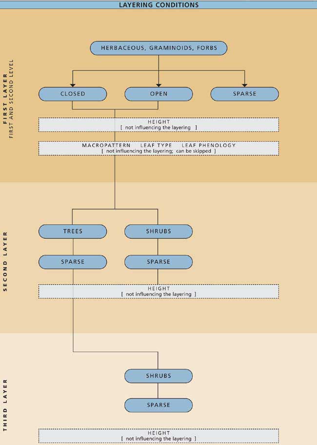
Figure A1.1 summarizes the above criteria for determining the dominant Life Form: Layering conditions for dominant life forms are illustrated in Figure A1.2 Trees; Figure A1.3 Shrubs; and Figure A1.4 Herbaceous/Forbs/Graminoids.
FIGURE A1.1
Matrix for determining the dominant Life
form
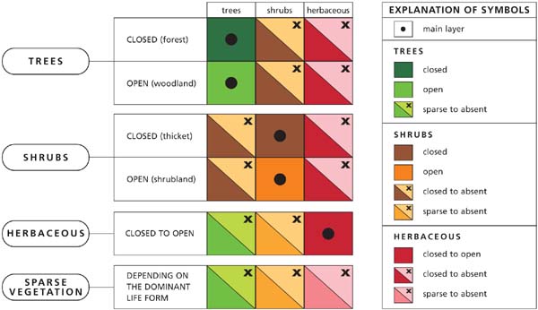
FIGURE A1.2
Layering criteria for
Trees
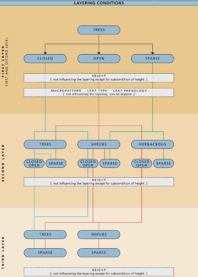
FIGURE A1.3
Layering criteria for
Shrubs
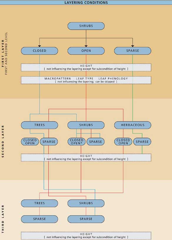
FIGURE A1.4
Layering criteria for
Herbaceous/Graminoids/Forbs
A1.1.2 WOODY (A12 AND A24)
Perennial plants with stem(s) and branches from which buds and shoots develop are defined as woody (Ford-Robertson, 1971). Semi-woody plants are included here (Eiten, 1968). Depending on the branching symmetry, a distinction is made between Trees and Shrubs (Strasburger et al., 1983). With reference to the International Classification and Mapping of Vegetation (UNESCO, 1973), bamboos and tuft plants (palms, tree ferns, etc.) can also belong to this category. Depending on their height, they are classified as Trees or Shrubs.
Guidelines
This special class had been created for plants in the 2-7 m range, when no further definition into Tree or Shrubs is specified.
The Woody class can be applied basically in two cases:
the vegetation is an intricate mixture of both trees and shrubs which cannot be distinguished and with height included in the 2-7 m range;
the user is not interested in further subdivision into trees or shrubs or has no information about it.
If the user does not know if the vegetation is composed by Trees or Shrubs, the use of mixed units is recommended (A//B).
A1.1.3 TREES (A12 AND A24)
A tree is defined as a woody perennial plant with a single, well-defined stem carrying a more-or-less-defined crown (Ford-Robertson, 1971) and being at least 3 m tall.
Guidelines
A condition of Height is applied to separate Trees from Shrubs: woody plants higher than 5 m are classified as Trees. In contrast, woody plants lower than 5 m are classified as Shrubs. This general rule is subject to the following exception: a woody plant with a clear physiognomic aspect of a tree can be classified as Trees even if the Height is lower than 5 m but more than 3 m. In this case, a subcondition of physiognomic aspect is added to the Height condition.
These are the recommended thresholds for Life Form characterization, but exceptions are allowed:
Plants essentially herbaceous but with a woody appearance (e.g. bamboos and ferns) are classified as Trees if the height is more than 5 m and as Shrubs if the height is less than 5 m.
For the classifier Woody (indistinct and/or intricate mixture of trees and shrubs), the higher limit is set at 7 m and the lower one at 2 m.
A1.1.4 SHRUBS (A12 AND A24)
Shrubs are woody perennial plants with persistent woody stems and without any defined main stem (Ford-Robertson, 1971), being less than 5 m tall. The growth habit can be erect, spreading or prostrate.
Guidelines
Life Form of a plant is defined by its physiognomic aspect. This is the case when Woody plants, sub-divided into Trees and Shrubs, are distinguished from Herbaceous plants, subdivided into Forbs and Graminoids, and Lichens/Mosses.
A condition of Height is applied to separate Trees from Shrubs: woody plants higher than 5 m are classified as Trees. In contrast, woody plants lower than 5 m are classified as Shrubs. This general rule is subject to the following exception: a woody plant with a clear physiognomic aspect of trees can be classified as Trees even if the Height is lower than 5 m but more than 3 m. In this case, a subcondition of physiognomic aspect is added to the Height condition.
These are the recommended thresholds for Life Form characterization, but exceptions are allowed:
Plants essentially herbaceous but with a woody appearance (e.g. bamboos and ferns) are classified as Trees if the height is more than 5 m and as Shrubs if the height is less than 5 m.
For the classifier Woody (indistinct and/or intricate mixture of trees and shrubs), the higher limit is set at 7 m and the lower one at 2 m.
This category in A12 includes: other Woody plants that are not 'shrublike' (e.g. ground lianas), Welwitschia and plants that are definitely not herbaceous (e.g. agave and cactoids).
A1.1.5 HERBACEOUS (A12 AND A24)
Plants without persistent stem or shoots above ground and lacking definite firm structure are defined as herbaceous (Scoggan, 1978). There are two categories, depending on the physiognomy, namely Graminoids and Forbs Forbs (Kuechler and Zonneveld, 1988; UNESCO, 1973).
Guidelines
The classifier Herbaceous can be applied in two cases:
The vegetation is an intricate mixture of different Life Forms (e.g. Forbs and Graminoids) forming a continuous layer of the two elements.
The level of detail of the description of the class does not require a separation between Forbs and Graminoids.
Forbs - Are all broad-leaved herbaceous plants in the common sense (e.g. sunflower, clover, etc., in A12) and all non-graminoid herbaceous plants (UNESCO, 1973). Therefore ferns, except tree ferns (Kuechler and Zonneveld, 1988) and very low, non-leafy succulents are included (Eiten, 1968).
Guideline
The category applies where Forbs comprise more than 75 percent of the overall Herbaceous coverage. In A24, a further distinction can be made into Rooted and Free-floating Forbs.
Rooted (A24) - These are aquatic plants that grow on a substrate but are structurally supported by water (UNESCO, 1973; Cowardin, 1979).
Free-floating (A24) - Defined as a non-anchored plant that floats freely in the water or on the water surface, e.g. formations like common duckweed (Lemna minor) or water hyacinth (Eichhornia crassipes) (UNESCO, 1973; Cowardin, 1979).
Graminoids - Includes all herbaceous grasses and other narrow-leaved grass-like plants that are not grasses according to the taxonomic definition (Kuechler and Zonneveld, 1988). Bamboos are technically grasses but they are Woody in form and therefore classed with Shrubs or Trees.
Guidelines
Graminoid vegetation is defined by the presence of more than 75 percent of Graminoids in the herbaceous coverage. There is no upper limit of height: the only condition is the physiognomy of the plant.
Lichens/Mosses (A12 and A24) - Lichens are composite organisms formed by the symbiotic association of fungi and algae. They are found encrusting rocks, tree trunks, etc. and they are often found under extreme environmental conditions (Lawrence, 1989). In tundras of North America and Eurasia, lichens (e.g. Cladonia spp.) may cover large areas (Kuechler and Zonneveld, 1988).
Mosses are a group of photo-autotrophic land plants without true leaves, stems or roots, but with leaf- and stemlike organs, e.g. sphagnum (Gray, 1970). Several plants commonly called "mosses" in fact belong to other groups: reindeer moss is a lichen; Spanish moss is a vascular plant (parasite) and Irish moss is an alga (Lawrence, 1989).
Guidelines
This category is only applied if the other Life Forms are not present and when
Lichen/Mosses cover more than 20 percent. Otherwise they do not form a specific class but their presence can be mentioned in the description of another land cover class.
Lichens as specific class is applied when both Lichens and Mosses are present and when
Lichens contribute 25 percent or more of the total cover.
Mosses as specific class is applied when both Lichens and Mosses are present and when
Mosses contribute 25 percent or more of the total cover.
A1.1.6 COVER (A12 AND A24)
The cover can be considered as the proportion of a particular area of the ground, substrate or water surface covered by a layer of plants, considered at the greatest horizontal perimeter level of each plant in the layer (according to Eiten, 1968). A distinction is made between closed (more than 60-70 percent), open (70-60 percent to 20-10 percent), closed to open (between 100 and 15 percent) and sparse (20-10 percent to 1 percent). The reason of expressing cover through ranges instead of using absolute values will be explained in the Guidelines below.
As herbaceous plants are seasonal in character, it has to be noted that the cover of herbaceous vegetation is always considered at the time of its fullest development.
Closed (more than 70-60 percent) - A layer of a certain Life Form covers more than 70-60 percent of a defined area. A closed cover composed of Trees or Shrubs has crowns interlocking, touching or very slightly separated. In the last-named case, the distance between two perimeters is no more than 1/6 of the crown average diameter (Eiten, 1968). The crowns can form an even or uneven closed canopy layer.
Guideline
If plants are growing in a defined area with the crowns touching each other, presuming that the crowns of a Woody Life Form are round, the cover of the canopy will be approximately 78 percent. However, crowns are in reality often interlocking and small open spaces in the canopy are frequent. Therefore, in a closed canopy layer, the lower limit of closed vegetation is set at 60 percent. Because of the great variability of the horizontal character of closed vegetation, in particular the different crown shapes of the plant species, the range of values can vary from 60 to 70 percent.
Open (70-60 to 20-10 percent) - Between 70-60 and 20-10 percent of a defined area is covered by a certain Life Form. In the case of Trees and Shrubs, the crowns are usually not interlocking. The distance between the perimeters can range from very small up to twice the average diameter (Eiten, 1968).
This category is further sub-divided into Open (70-60 to 40 percent) and Very Open (40 to 20-10 percent).
Guideline
In the case of woody vegetation with a cover of between 70-60 and 40 percent, the plants are standing rather close together and, from a distance, they may appear to grow continuously (Kuechler and Zonneveld, 1988). To separate the two subclasses, the limit is set at 40 percent. The practical reason behind this is that at 40 percent coverage with Trees the distance between two perimeters equals the mean radius of a tree crown (UNESCO, 1973).
Sparse (20-10 to 1 percent) - Between 20-10 and 1 percent of a defined area is covered by a certain layer of plants. The distance between two perimeters of a Life Form is more than twice the average perimeter diameter (Eiten, 1968). In many cases, a sparse Life Form might be associated with another Life Form of greater cover continuity, e.g. savannas are characterized by sparse trees standing out from a herbaceous closed or open layer. Subdivision is made into Sparse (20-10 to 4 percent) and Scattered (4 to 1 percent).
Guidelines
There are two reasons for the application of the range of 20 to 10 percent:
There is a great variability in the horizontal character of closed vegetation, namely different crown densities or crown shapes of the plant species (see also closed).
Sparse cover is rarely homogenous but grows in clumps and therefore cannot easily be defined as one single value.
Close to Very Open (100 to 15 percent) - A layer of a certain Life Form covers between 100 percent and 15 percent of a defined area. The crowns can form an even or uneven closed canopy layer (see also: open; closed).
Close to Open (100 to 40 percent) - A layer of a certain Life Form covers between 100 percent and 40 percent of a defined area. The crowns can form an even or uneven closed canopy layer (see also: open; closed).
A1.1.7 HEIGHT (A12 AND A24)
The height of a certain layer is measured from the ground to the average top of the Life Form being assessed (Kuechler and Zonneveld, 1988). The fact that single plants of one synusia differ from the average height can be ignored, apart from the fact that they can form their own layer (e.g. the emergents of a rainforest that tower above the rest).
Height sub-divisions are: >30 down to 3 m for Trees; 5 m to 0.3 m for Shrubs; and 3 m to 0.03 m for Herbaceous. Each class is further sub-divided.
Guidelines
There is an overlap between the lower height limit for trees and the upper limit for shrubs and also between the minimum height for shrubs and the maximum height for herbaceous.
Height classes are directly related to Life Forms as Height plays a complementary role in the definition of the structural classes. When a specific Height class is chosen, the user deliberately decides to give more emphasis to Height in the classification.
A1.1.8 SPATIAL DISTRIBUTION - MACROPATTERN (A12 ONLY)
Spatial distribution, or Macropattern, is concerned with the horizontal distribution of the vegetation (Feoli et al, 1991).
Macropattern is further sub-divided into: Continuous, Fragmented and Parklike Patches.
Guidelines
The Macropattern shows an ecological or a degradation aspect of vegetation (e.g. scattered vegetation in arid areas, agricultural encroachment inside forest areas, degradation due to overgrazing, etc.). In many classifications, one finds terms that are extremely subjective, like "Degraded Forests" or similar. The classification presented here aims to be neutral in land cover description, without including ambiguous terminology. Therefore Macropattern is selected as a neutral classifier to describe the vegetation status:
The classification presented here was built up for mapping purposes, therefore, spatial distribution of land cover is an important aspect; and
Macropattern is easily detectable from remote sensing data (photographs and imagery), i.e. it has great "mappability."
Macropattern should thus be used to give supplementary ecological information (or to show a human-induced evolution aspect of natural vegetation). The user has the possibility to skip this classifier if it is felt to be irrelevant information.
Macropattern is defined as the horizontal spatial distribution of vegetation in a certain area. It should not be confused with Cover, which defines the spatial arrangement of Life Forms (e.g. trees and shrubs). Macropattern describes the spatial arrangement of specific structural vegetation types (e.g. Closed Forest and Closed Shrubs).
The combinations between Cover and Macropattern are unrestricted (this is nevertheless only valid for Closed Cover and Open Cover, as will be explained later. This means that, for instance, a closed tree formation (Closed Forest) can be either Continuous or Fragmented, depending on its spatial distribution in the mapping unit.
Because of this dimensional aspect, Macropattern is linked to the mapping scale. This may seem to contradict the main classification concept explained earlier, which states that the elements of a classification system must be scale-independent. To determine Macropattern, one should refer to the overall appearance of a vegetation formation in a certain area in a homogeneous landscape. However, if one wants to be more precise or objective in the application of this classifier, some specific rules are given below to help to standardize the interpretation. Because we are dealing with the practical application of this concept in a cartographic context, the concepts of mixed units and minimum mappable areas will be used.
A certain structural vegetation type has a continuous Macropattern if it covers more than 80 percent of the area inside the minimum mappable area.
A certain structural vegetation type has a fragmented Macropattern if it covers more than 20 percent but less than 80 percent inside the minimum mappable area. This situation is linked with the concept of mixed unit.
Three cases are possible:
The structural vegetation type (e.g. dense forest) covers more than 50 percent of the area and the other element (e.g. agricultural fields) less than 50 percent but more than 20 percent. In this case, the resulting unit will be a mixed unit with the fragmented dense forest as the dominant element (e.g. fragmented dense forest/agricultural fields).
The structural vegetation type (e.g. dense forest) covers less than 50 percent but more than 20 percent of the area. The other element (e.g. agricultural fields) covers more than 50 percent. In this case, the class is mixed, but the dominant class will be the agricultural fields (e.g. agricultural fields/fragmented dense forest).
When a unit contains three elements (e.g. fragmented dense forest, agricultural fields and bare areas) the rules for mixed units should be applied. In this case, it could be possible to have a structural vegetation type with a fragmented Macropattern as a single unit (e.g. fragmented dense forest 70 percent, agricultural fields 15 percent, and bare areas 15 percent. Neither of the minor elements reaches a cover of more than 20 percent of the unit; thus, the unit must be considered a single mapping unit of fragmented dense forest). This is the only case when a structural vegetation type with fragmented Macropattern must be considered as a single mapping unit. Even if theoretically possible, this case must be considered a very unusual one and therefore should be avoided.
The Continuous or Fragmented classifiers are linked with Closed Cover or Open Cover (e.g. Closed Continuous Forest, Closed Fragmented Forest, Continuous Woodland or Fragmented Woodland). Fragmentation can be further sub-divided into Striped and Cellular (e.g. tiger bush in the Sahel, where Closed Shrubs are present in the interdunal areas and which can be represented as Fragmented (Striped) Closed Shrubs).
The Macropattern Parklike Patches is directly linked with the cover Sparse. This is simply redundant information. When the user defines the cover of a certain life form as Sparse, the only Macropattern available for this structural vegetation type is Parklike Patches.
The Macropattern is preferentially used for Woody life forms (Trees, Shrubs). Herbaceous life forms (Graminoids, Forbs) can have a Macropattern, but this is subordinated to the absence of Woody life forms. Thus, when linear patches of dense shrubs (typical of tiger bush) are present together with dense herbaceous vegetation covering the space between the different patches, one can see it in two different ways: as either fragmented shrubs/herbaceous or fragmented herbaceous/shrubs. The above-mentioned rule of preferentially favouring Woody life forms obliges the user to always give preference, in the application of the Macropattern, to the Woody component. Macropattern can be applied to Herbaceous life forms only when there is no significant presence of Woody life forms (Trees, Shrubs). For instance, patches of dense Herbaceous vegetation in sandy areas can be called fragmented herbaceous/sand.
A structural vegetation type is fragmented when the sizes of the patches of the vegetation are between 1/15 and 1/2 of the minimum mappable unit. This rule is a very artificial one and does not need to be strictly applied. This rule assists the user by providing some indication of how a fragmented Macropattern should look. If the patches were too small, then at a certain level they could coincide with the life form itself, thus contradicting the basic rule explained above (i.e. Macropattern describes the specific arrangement of structural vegetation types and must not be confused with the cover of the life form).
Continuous - A given cover can be Open, Closed or Closed To Open, but to be considered Continuous, the vegetation has to be spread over the area with regularity and without interval or break.
Guideline
A certain structural vegetation type has a Continuous Macropattern if inside the minimum mappable area it covers more than 80 percent of the area.
Fragmented - A given cover can be Open, Closed, or Closed To Open, but it is interrupted in the sense of Striped or Cellular fragmentation.
Guidelines
A certain structural vegetation type has a fragmented Macropattern if inside the minimum mappable area it covers more than 20 percent but less than 80 percent. This situation is linked with the concept of mixed unit. Three cases are possible:
The structural vegetation type (e.g. dense forest) covers more than 50 percent of the area and the other element (e.g. agricultural fields) less than 50 percent but more than 20 percent. In this case, the resulting unit will be a mixed unit with the fragmented dense forest as the dominant one (e.g. fragmented dense forest/agricultural fields).
The structural vegetation type (e.g. dense forest) covers less than 50 percent but more than 20 percent of the area. The other element (e.g. agricultural fields) covers more than 50 percent. In this case, the class is mixed but the dominant class will be the agricultural fields (e.g. agricultural fields/fragmented dense forest).
When a unit contains three elements (e.g. fragmented dense forest, agricultural fields and bare areas) the rules for mixed units should be applied. In this case, it could be possible to have a structural vegetation type with a fragmented Macropattern as single unit (e.g. fragmented dense forest, 70 percent; agricultural fields, 15 percent; and bare areas, 15 percent. Neither of the two minor elements reach a cover of more than 20 percent of the unit; thus, the unit must be considered a single mapping unit of fragmented dense forest). This is the only case when a structural vegetation type with fragmented Macropattern must be considered as a single mapping unit. Even if theoretically possible, this case must be considered a very unusual one, therefore should be avoided.
Parklike Patches - In the case of woody vegetation, Parklike Patches signifies that trees and shrubs grow singly or in small groups as in parklands and in savannahs. When herbaceous vegetation is present, it signifies disconnected patches (Kuechler and Zonneveld, 1988).
Guideline
The Macropattern Parklike Patches is directly linked with the cover Sparse. This is simply redundant information. When the user defines the cover of a certain life form to be Sparse, the only Macropattern available for this structural vegetation type is Parklike Patches.
A1.1.9 WATER SEASONALITY (A24 ONLY)
Water Seasonality refers to the type of persistence of the water at or near the surface. A sub-division is made into three classes: (Semi-)Permanent (approximately three months a year or more than a specific season), Temporary or Seasonal (less than three months a year or during a specific season) and Waterlogged.
(Semi-)Permanent - In this class, areas are considered to be covered by water for a substantial period, which is not directly linked to a specific season. The class can be further sub-divided into two subclasses: one where water is persistent the whole day (no tidal influences), and one where there is a tidal influence.
Temporary or Seasonal - This class covers areas that are regularly flooded, but where the water cover does not remain for a substantial period of time or other than in a particular season.
Waterlogged - The water table is very high and at or near the surface. These areas could be occasionally flooded, but the main characteristic is the high level of the water table (e.g. bogs).
A1.1.10 LEAF TYPE (A12 AND A24)
Leaf type is applied only when characterizing Trees and Shrubs. A distinction is made between Broadleaved, Needleleaved and Aphyllous.
Broadleaved - This refers to trees and shrubs of the botanical group Angiospermae, with Gingko (Gingko biloba) as an exception, as it is broadleaved but taxonomically belongs to the Gymnospermae. Both Evergreen and Deciduous species belong to this category.
Needleleaved - This refers to trees and shrubs of the botanical group Gymnospermae (Ford-Robertson, 1971), carrying typical needle-shaped leaves.
Guideline
Both evergreen conifers like pines (Pinus spp.), hemlock (Tsuga spp.) and firs (Abies spp.), etc., as well as deciduous conifers like the larch (Larix spp.), are included in A12. It is also applied to scale-like leaves, especially leaves of arbor vitae (Thuja occidentalis). Contrary to usual definitions, this category includes all plants with needle-like leaves, even though they are not conifers, such as some Australian acacias (e.g. Acacia asparagoides).
Aphyllous - This category includes plants without any leaves and plants that apparently do not have leaves in the common sense. In the first case, photosynthesis takes place through other organs, like stems, branches and twigs; in the latter case, the leaves are very short-lived or extremely reduced to scales and thorns.
A1.1.11 LEAF PHENOLOGY (A12 AND A24)
The leaf phenology refers to the general behaviour of woody plants throughout the year. Two types have to be distinguished: Evergreen and Deciduous. A further distinction is made between Mixed and Semi-Deciduous or Semi-Evergreen. The leaf phenology of herbaceous plants is classified through the mixed category. A separation can be made between Perennial and Annual vegetation.
Evergreen - This term as such describes the phenology of perennial plants that are never entirely without green foliage (Ford-Robertson, 1971).
Guideline
For this class to be applicable, there must be a whole layer that is more than 75 percent evergreen vegetation.
Deciduous - This applies to the phenology of perennial plants that are leafless for a certain period during the year (Ford-Robertson, 1971). The leaf shedding usually takes place simultaneously in connection with the unfavourable season (UNESCO, 1973).
Guideline
For this class to be applicable, there must be a whole layer that is more than 75 percent deciduous vegetation.
Mixed (Woody Life Form) - This category is limited exclusively to a layer with a mixture of broadleaved deciduous and needleleaved evergreen vegetation (Kuechler and Zonneveld, 1988).
Guideline
Within this combination, it is necessary that each of the two components occupy at least 25 percent of the area.
Semi-Deciduous or Semi-Evergreen - This applies to the broadleaved category, as under tropical conditions deciduousness is difficult to define, especially as the seasonal variation influences the time of leaf-shedding; plants are deciduous in certain areas, evergreen in others.
Guideline for Semi-Deciduous
This term applies to a combination of broadleaved deciduous that is dominant and broadleaved evergreen being more than 25 percent.
Guideline for Semi-Evergreen
This term applies to a combination of the dominance of broadleaved evergreen and with broadleaved deciduous being more than 25 percent.
Mixed (only for Forbs and Graminoids) - This category is limited to a layer with a mixture of perennial or annual herbaceous plants.
Guideline
With both perennial and annual plants being present, each type must cover at least 25 percent of the area.
A1.1.12 STRATIFICATION AND LIFE FORM OF OTHER THAN THE MAIN STRATUM (A12 AND A24)
Stratification, or layering, is defined as the vertical layering of vegetation. It should not be confused with Macropattern, which describes the horizontal distribution of Life Forms, nor with Cover, which describes the presence of one single Life Form.
Guidelines
The user can describe up to three layers for (Semi-)Natural Terrestrial Vegetation (A12) and two layers (the main layer + one other) for Aquatic or Regularly Flooded Vegetated Areas (A24). The limited number of available layers may disappoint the user, but the classifier Stratification should contribute to the structural definition of a vegetation class. This means that this classifier must consider all the possible combinations with the main Life Form selected and its Cover (e.g. if we can have layering for Closed Trees, the same must be valid for Closed or Open Shrubs or Closed Graminoids, etc.). The layering is an active component of the class set-up; it is not a mere descriptive (optional and unsystematic) item of the class. The proposed classification allows the user to first build up a land cover class with the use of the classifier Stratification and, if more details are wanted, to add a user's description to the standard one, which can contain information on any additional layers/strata.
Some limitations in the use of the classifier Stratification have been introduced in order to avoid class combinations that are irrelevant from the structural point of view. These limitations prevent introduction of elements that are not crucial for the determination of the structural aspects of a land cover class. These elements can be added in the class description in the Legend (see Legend > Edit). These limitations have the practical purpose of reducing the number of possible combinations of classifiers, which otherwise could lead to creation of an even larger number of classes that would all have the same structural meaning. All limits to the use of Stratification are built into the software.
From a practical point of view, in the use of the Stratification concept, it is important to recognize two types of Stratification:
where the second stratum consists of the same Life Form as the main stratum (e.g. trees-trees and shrubs-shrubs); and
where the second stratum consists of a different Life Form (e.g. trees-shrubs).
The second case is quite straightforward and does not present any difficulty in the selection of classifier. The first case needs additional explanation. In the case of a dominant Life Form of Trees with a second stratum of Trees, it is important that these layers are clearly distinguishable one from the other (e.g. second stratum of Trees Emergent over a Closed Tree canopy; these emergents must not be part of the discontinuity of the Closed Tree canopy but a clearly distinct layer). The sub-condition of Height will preset the available choices of Height for a second and (for A12 only) a third layer (e.g. with a main stratum of Closed Low Trees (3-7 m), the emergents to be defined in the second stratum cannot have the same height (option 3-7 m is therefore not available) because the Sparse Trees of the second layer have to be taller).
The Height condition explained above depends on the detailed option for Height chosen for the main stratum; it is not applied if the general Height class is selected. If the user selects the general Height class for the main stratum, then for subsequent strata the general Height classes are the only options available.
The main conditions applied for Stratification/Layering are the following:
Forbs and Graminoids are considered always together as Herbaceous.
For Trees, three strata including the main, can be considered in A12 (e.g. a main Closed Tree layer with a second, lower, Closed to Open Tree layer and a third Sparse Tree layer of emergents would be termed a Multi-Layered Forest With Emergents); in A24 two strata including the main are allowed.
When the main stratum is Closed Trees or Open Trees and there is a second layer Sparse Trees, then the Height of the second layer must be higher, i.e. emergent; if it is lower, they are not considered as an independent stratum.
For Shrubs, the number of strata with the same Life Form is two, including the main stratum.
For Herbaceous, only one stratum is possible.
Lichens/mosses are not described in the layering.
If the main stratum is Trees and the Cover is Open, then it is impossible to have the same Life Form with Cover Open To Closed with a different height as a second stratum (e.g. Open High Trees with Open Low Trees is impossible).
If the main stratum is Shrubs and the Cover is Closed or Open, then it is impossible to have as a second stratum the same Life Form with Cover Open To Closed but with a different height (e.g. Open High Shrubs with Closed To Open Low Shrubs is impossible). The only exception to this rule is when the second stratum consists of Dwarf Shrubs.
If the cover of the main stratum is Closed Trees or Closed Shrubs then any Herbaceous layer possibly present is not considered or described (this can be added as a user-defined description).
Sparse Herbaceous is never considered as second layer except when the main layer is Sparse Trees or Sparse Shrubs (but it can be added as a user-defined description).
If the main stratum is Shrubs or Herbaceous, only one layer of trees can be considered; this is linked with the criterion of dominance as described earlier, because the Trees or Shrubs can be only Sparse.
Only two layers other than the main layer are considered for Terrestrial Vegetation (A12) and only one additional stratum for Aquatic Vegetation (A24).
A1.1.13 FLORISTIC ASPECT (A12 AND A24)
This attribute has two major divisions based on whether it is derived from a single plant species or from a group of plants. In the first case, a further sub-division is possible into Dominant Species (Height, Cover or combination of both) or Most Frequent Species. The second sub-division is sub-divided again into Plant Groups (e.g. Braun-Blanquet) and Plant Groups Derived Without Statistical Methods (i.e. same ecological significance, same geographical distribution, same dynamic significance, etc.). The specific name of the Floristic Aspect can be added using the User-Defined Attribute option in the Legend Module.
A1.2
CULTIVATED AND MANAGED AREAS
(A11 AND
A23)
A1.2.1 LIFE FORM OF THE MAIN CROP (A11 AND A23)
A Life Form is a group of plants having certain morphological features in common (Kuechler and Zonneveld, 1988).
For further classification the following growth form criteria are used (Strasburger et al., 1983; Kuechler and Zonneveld, 1988):
Guidelines
Contrary to Natural and Semi-Natural Vegetation (A12), Cultivated Areas are not described by classifiers such as Height or Cover. They are classified exclusively according to their morphology.
Contrary to the major land cover type A11, in A23 a distinction is only made between Graminoids and Non-Graminoids.
The main crop is entirely defined as the vegetative cover which is not marginal, i.e. which covers a considerable area (more than 15 percent of the surface) or which has a high economic revenue and comprises the uppermost canopy. A second and/or third crop type can be specified, but these crops have a lower canopy than the main crop or they are a marginal crop, i.e. cover less than 15 percent of the surface or has a low economic revenue.
A1.2.1.1 Trees (A11 only)
A tree is defined as a woody perennial plant with a single, well defined stem carrying a more-or-less-defined crown (Ford-Robertson, 1971). The plants often form a distinct block and are often planted in a regular spacing or pattern (e.g. orchards, nursery stocks). The duration of the crop cover usually lasts many years.
Guidelines
This category includes:
A further distinction is made as follows:
Broadleaved - This refers to Trees of the botanical group Angiospermae, with Gingko (Gingko biloba) as an exception, as it is broadleaved but belongs taxonomically to the Gymnospermae. Both evergreen and deciduous species come into this category.
Needleleaved - This refers to Trees of the botanical group Gymnospermae (Ford-Robertson, 1971) carrying typical needle-shaped leaves. Both evergreen and deciduous species come into this category.
Evergreen - This refers to the phenology of perennial plants that are never entirely without green foliage (Ford-Robertson, 1971).
Deciduous - This refers to the phenology of perennial plants which are leafless for a certain period during the year (Ford-Robertson, 1971). The leaf shedding usually takes place simultaneously in connection with the unfavourable season (UNESCO, 1973).
A1.2.1.2 Shrubs (A11 only)
A shrub is a woody perennial plant with persistent and woody stems and without any defined main stem (Ford-Robertson, 1971). The growth habit can be erect, spreading or prostrate. The plants often form a distinct block and are often planted in a regular spacing or pattern (e.g. orchards; nursery stock).
Guidelines
This category includes:
Shrubs used for harvesting the fruits, berries, leaves, etc., such as vine, cotton, coffee, cocoa, tea and soft fruits (currants, blackberries, etc.).
Pineapple as a succulent plant is included here due to its appearance.
Any kind of nursery stock with the plants mentioned above. A further distinction is made as follows:
Broadleaved - This refers to Shrubs of the botanical group Angiospermae, with Gingko (Gingko biloba) as an exception, as it is broadleaved but belongs to the Gymnospermae taxonomically Both evergreen and deciduous species come into this category.
Needleleaved - This refers to Shrubs of the botanical group Gymnospermae (Ford-Robertson, 1971) carrying typical needle-shaped leaves. Both evergreen and deciduous species come into this category.
Evergreen - This refers to the phenology of perennial plants that are never entirely without green foliage (Ford-Robertson, 1971).
Deciduous - This refers to the phenology of perennial plants which are leafless for a certain period during the year (Ford-Robertson, 1971). The leaf shedding usually takes place simultaneously in connection with the unfavourable season (UNESCO, 1973).
A1.2.1.3 Herbaceous (A11 only)
This applies to plants without persistent stem or shoots above ground and lacking definite firm structure (Scoggan, 1978). The cover duration is limited to the harvest stage. A further distinction is made between Graminoids and Non-Graminoids (Kuechler and Zonneveld, 1988).
Graminoids (A11 and A23) - This includes all grasses and other narrow-leaved, grass-like plants that are not grasses according to the taxonomic definition (Kuechler and Zonneveld, 1988).
Guidelines (A11)
The following crops are included:
Guidelines (A23)
The following crops are included:
Non-Graminoids (A11 and A23) - This includes all herbaceous plants that are not Graminoids, i.e. species that do not belong to the grasses according to the taxonomic definition, but excludes narrow-leaved, grass-like plants which are considered Graminoids for the purposes of classification (Kuechler and Zonneveld, 1988). A lot of species in A23 cover water surfaces with a large amount of biomass.
Guidelines (A11)
The following crops are included:
Woody (A11 and A23) - Perennial plants with stem(s) and branches from which buds and shoots develop are defined as woody (Ford-Robertson, 1971). Semi-woody plants are included here (Eiten, 1968).
Guidelines
This classifier can be used to specify an aquatic crop not considered in the category of herbaceous crop.
A1.2.2 LIFE FORM MANAGED LANDS (A11 ONLY) Urban Vegetated Area
This class includes vegetated areas that are enclosed by any kind of urban construction. These areas form isolated patches within the urban area. According to the dominant Life Form of the particular urban vegetated area, a further distinction can be made between:
Parks, where the dominating life form is Trees. These parks may appear natural but the distribution of the trees and other life forms present is designed.
Parklands, characterized by cover dominated by (ornamental) herbaceous vegetation (e.g. Forbs and Graminoids) with scattered groups of trees and/or shrubs.
Grass-dominated areas (lawns) dominated by Graminoids. If trees and/or shrubs are present then they form a linear pattern surrounding the graminoid-dominated area(s).
A1.2.3 SPATIAL ASPECT - FIELD SIZE AND DISTRIBUTION (A11 AND A23)
The Spatial Aspect describes cultivated fields in terms of field size (e.g. dimension) and their distribution.
A1.2.3.1 Field Size (A11 and A23)
This class can be applied indicatively A distinction is made between Large-to-Medium-Sized Fields and Small-Sized Field(s). However, this does not refer to large-, medium- or small-scale farming, because it does not relate to the overall size of the farm holding. The following distinctions are made:
A1.2.3.2 Distribution (A11 and A23)
Spatial Distribution, or Macropattern, is concerned with the horizontal spatial arrangement of the field(s) within a defined area.
A distinction is made between Continuous and Scattered field(s).
Guideline
Spatial Distribution can be easily measured by considering the distance between a field and the next field. A further distinction can be made into three classes: Continuous, Scattered Clustered or Scattered Isolated.
Continuous - A given crop cover extends over an area without interval or break.
Guidelines
Continuous describes a continuum of more than 50 percent of cultivated fields. In this case the land cover mapping unit may be single (inside the mapping unit, the fields take up more than 80 percent) or mixed (the fields occupy 51-80 percent of the mapping unit). Generally, when the fields occupy 51-80 percent of the mapping unit, the area in between the fields can be considered as part of the cultivated area by the user or the user can decide to make a mixed mapping unit, depending upon which land cover features the user wants to highlight.
Scattered Clustered and Scattered Isolated - The Spatial Distribution is Scattered Clustered or Scattered Isolated when, within the area of cultivated field, other land cover types are present.
Guidelines
Where the percentage of fields is more than 20 percent but less than 50 percent, it is Scattered Clustered; this means that the resulting mapping unit is a mixed land cover class of a cultivated area with another subordinate land cover class, and both components need to be defined in the legend (e.g. 40 percent fields and 60 percent semi-natural vegetation).
Where the percentage of fields is more than 10 percent but less than 20 percent, it is Scattered Isolated; this means that the resulting mapping unit is a mixed land cover class where the dominant class is not "scattered isolated". It is the only case where a class comprising less than 20 percent is present in a mixed mapping unit.
A1.2.4 CROP COMBINATION (A11 ONLY)
The dominant crop may be sole or in combination with other crops. A distinction is made between Single Crop and Multiple Crops.
Single Crop (Monoculture) - This refers to a cultivation system in which a single crop species covers a plot of land, i.e. a monocultural cropping system. The cover duration is limited by the harvest stage.
Guidelines
Multiple Crop (Intercropped) - Cultivation of two or three crops that are growing simultaneously or with a period of overlap or sequentially on the same field. Crop intensification is both in time and space (vertical and horizontal). No horizontal spatial arrangement of the crops (e.g. rows, strips or no arrangement) is considered.
Guideline
The Multiple Crop system can be further sub-divided into One Additional Crop and More Than One Additional Crop. They can be specified by Life Form and coincidence of their planting time with the main crop.
Simultaneously - More than one crop is cultivated at the same time in a defined area. This is often indicated as mixed cropping. Therefore the different crops can be intermingled or they grow in distinct patterns on the same field.
Guidelines
Mixed annual crops are cultivated on one piece of land. For example: Legumes are often combined with Non-Legumes.
In the case of perennial crops (trees and shrubs), cash crops are interplanted during the period of establishment of the main crop. At a later stage the interplanted crops might be replaced by cover crops (Euroconsult, 1989).
Overlapping - This occurs when a crop is planted or sowed into another crop which has reached an advanced growing stage but has not yet been harvested (Lipton, 1995).
Guideline
This class applies only to crops with briefly overlapping growing periods. An overlap that lasts for the whole cultivation period (e.g. if annual or biennial plants are planted into a stand of perennial plants) is considered Simultaneous. An example of crops with an overlapping period is when root crops are planted into a stand of cereals.
Sequential - The growing of two or more crops in sequence on the same field within one growing season. The succeeding crop is planted after the preceding one is harvested.
A1.2.5 COVER-RELATED CULTURAL PRACTICES - WATER SUPPLY (A11 ONLY)
A distinction is made between rainfed, post-flooding and irrigated cultural practices.
Rainfed Cultivation - Crop establishment and development is completely determined by rainfall.
Post-Flooding Cultivation - After rainwater has flooded the field, the water infiltrated into the soil is used intentionally as a water reserve for crop cultivation. The crop(s) use(s) this water reserve for establishment.
Irrigated - Any of several means of providing an artificial regular supply of water, in addition to rain, to the crop(s).
This category is further sub-divided into the main irrigation methods:
Guidelines
Under Irrigated, other systems are also included, in which an additional watergift, essential for establishment and/or flowering of the crop, depends on the actual rains. The aim of the additional watergift is to help the plants through a period of drought stress (examples of this practice can be found in (semi-)arid climates).
Surface Irrigation - Water is supplied to the field(s) to form a water layer that infiltrates slowly into the soil. The field may be wetted completed (borders, basins) or partly (furrows, corrugations). The water layer may be moving during irrigation (flow irrigation) or it may be mainly stagnant (check irrigation).
Sprinkler Irrigation - Water is pumped up from a source into a closed distribution network and then conveyed over the soil surface and crops. The irrigation water is applied by means of rotating sprinklers, perforated pipes, sprayers or spinners that are connected to the network. The distribution networks may be permanent, portable or a combination of the two.
Drip Irrigation - This type of irrigation is also called trickle, dribble or localized irrigation. The water is applied at very low pressure through a network of plastic tubes running along the surface or buried. The network consists of main lines and laterals (Euroconsult, 1989). The water trickles onto the soil near the plant(s) at a confined spot.
A1.2.6 WATER SEASONALITY (A23 ONLY)
Water Seasonality reflects the persistence of water at or near the surface. A subdivision is made into three classes: Persistent, With Daily Variations and Waterlogged.
Persistent for the Whole Day During Cultivation Period
This class applies to areas covered by water for the whole day, directly
linked to the cultivation period.
With Daily Variations During Cultivation
Period
This class includes areas regularly flooded by water but not for a substantial
period. The persistence of the water is linked to the cultivation period.
Waterlogged
The water table is very high and at or near the surface. These areas could
be occasionally flooded but the main characteristic is the high level of
the water table (e.g. bogs).
A1.2.7 COVER-RELATED CULTURAL PRACTICES - CULTIVATION TIME FACTOR (A11 ONLY)
This classifier indicates for how much of the growing season(s) the land is covered by crops. A distinction is made between shifting cultivation, fallow system and permanent cultivation.
Shifting Cultivation - This describes the growing of crops for a few years on selected and cleared plots, alternating with a lengthy period of vegetative fallow when the soil is rested. The land is cultivated for less than 33 percent of the time (Ruthenberg, 1980). This cover is followed by the vegetative and/or bare cover of the fallow period, that can last for several years (Shaner et al., 1982).
Guidelines
The traditional system of the shifting cultivation results in various cover appearances (WAU, 1985)
1. The existing vegetation on plots is cleared and burnt. Therefore the lower herbaceous vegetation layer is removed, followed by partial tree and shrub removal. Trees that deliver fruits to harvest are sometimes left. Tree stems might remain as a frame for later yam production. During this period, hardly any vegetation is left. These cleared plots are characteristically surrounded by land that is covered with primary and/or secondary "Natural or Semi-Natural Vegetation."
2. In the next phase, crops cover the land. Because this production system is extensive, the crop cover might be mixed with spontaneous re-growth of vegetation that developed soon after the plot was burnt. In general, cereals are sown first, followed by root and tuber crops. Sometimes root and tuber crops are planted immediately. A common worldwide crop combination starts with cereals, like maize or rice, later interplanted with a root crop, like cassava or bananas, before the cereal is harvested (see also overlapping crops).
3. After the cultivation period is completed, the secondary semi-natural vegetation starts to fully develop. The amount of this type of semi-natural vegetation increases steadily. As soon as this secondary vegetation dominates the cultural plants, the area is no longer classed under Cultivated Terrestrial Areas, but under Natural and Semi-Natural Vegetation.
Fallow System - An agricultural system with an alternation between a cropping period of several years and a fallow period. The land is cultivated for 33 to 66 percent of the years, which means 50 percent is given by three, five or ten years of crop cover followed by three, five or ten years of fallow vegetative cover (Ruthenberg, 1980).
Guidelines
Because the fallow period is short, the cover consists mostly of grass and light bush vegetation. Areas covered with a distinct closed fallow vegetation without visible field delineations are classed under Natural and Semi-Natural Terrestrial Vegetation. These visible field divisions are characteristic of Fallow Systems. Annual and biennial crops dominate the cover of this cultivation system. The cover of a fallow system is composed of a staple crop (like millet or maize), or a dominating cash crop (like cotton, groundnut, rice or tobacco), and a fallow area.
Permanent Cultivation - This applies to the growing of crops that are not replanted for several years after each harvest (e.g. trees and shrubs). The crop should cover the land for at least two years. The first harvest usually takes place after one year or later. Under this cultivation system the land is cultivated for more than 66 percent of the years (Ruthenberg, 1980).
Guidelines
In the case of annual plants, the crop covers the land only part of the year and is followed by a short fallow period or by another crop or covercrop. Examples are vegetables and rice.
In the case of perennials, the crop covers the land throughout the year.
The following crops are included (WAU, 1985):
A1.2.8 COVER-RELATED CULTURAL PRACTICES - FALLOW PERIOD (A23 ONLY)
A distinction is made between Permanent Cultivation, Relay Intercropping and Sequential cultivation.
Permanent Cultivation - This is the growing of crops that do not have to be replanted for several years after each harvest (e.g. trees and shrubs). The crop should cover the land for at least two years. The first harvest usually takes place after one year or later. The area is covered by crops for more than 66 percent of the years (Ruthenberg, 1980).
Relay Intercropping - Planting or sowing one crop into another, maturing crop (Ruthenberg, 1980).
Sequential - The growing of two or more crops in sequence on the same field within one growing season. The succeeding crop is planted after the preceding one is harvested.
A1.2.9 CROP COMBINATION (A23 ONLY)
The dominant crop may be appearing solely or in combination with other crops. A distinction is made between One Additional Crop and Two Additional Crops.
- Herbaceous Aquatic
- Herbaceous Terrestrial
- Herbaceous Aquatic
- Herbaceous Terrestrial
A1.2.10 CROP TYPE (A11 AND A23)
The crop type can be added optionally, with various levels of detail. Initially, a distinction is made between Food Crops and Non-Food Crops. A further sub-division is made specifying the most common crop species. Food Crops can be differentiated into Cereals, Roots and Tubers, Pulses and Vegetables, Fruits and Nuts, Fodder, Beverages and Other.
Non-Food Crops comprise Industrial Crops, Wood/Timber and Other Non-Food Crops. The species are grouped according to the main product being harvested.
For A11, a number of groupings have been made.
Food Crops - Food Crops can be differentiated into Cereals; Roots and Tubers; Pulses and Vegetables; Fruits and Nuts; Fodder Crops; Beverages/Stimulants and OtherCrops.
Cereals - In addition to cereals in the narrow sense, the so-called pseudo-cereals are also included:
Roots and Tubers
Pulses and Vegetables
Fruits and Nuts
Fodder - As there is an enormous number of species used for fodder (Rehm and Espig, 1991), a division is only made into fodder grasses and fodder legumes. Fodder as a byproduct of other crops is not considered here.
Beverages - This includes also stimulants that are not beverages. Not included are beverages produced from fruit crops, even if this is the main use in certain regions. Therefore grapes, citrus and others are listed under Fruits and Nuts.
Non-Food Crops - Non-Food Crops comprise Industrial Crops and Wood/Timber crops.
Industrial Crops - This class includes crops that provide raw materials generally subject to further mechanical or industrial processing, like fibre crops and oil crops. Oils that can be considered as by-products, for example oil from grain embryos or from the seeds of vegetables, fibre plants, etc., are not mentioned here.
Wood/Timber
For A23 the following groupings have been made:
Food Crops - Food Crops can be differentiated into Cereals, Fodder Crops and Other Food Crops.
Cereals
Fodder
Other Crops
Non-Food Crops - Non-Food Crops are sub-divided into Biological Filtration, Fibre and Structural Material and Other Non-Food Crops. The species are grouped according to the main product being harvested.
Biological Filtration
Fibre and Structural Material
Other Crops
A1.3
ARTIFICIAL SURFACES AND ASSOCIATED
AREAS
A1.3.1 SURFACE ASPECT
The surface aspect of areas with an artificial or associated cover is described. Two main classes are distinguished: built-up areas and non built-up areas.
Built up - Built-up areas are characterized by the substitution of the original (semi-)natural cover or water surface with an artificial, often impervious, cover. This artificial cover is usually characterized by a long cover duration.
This class can be sub-divided into linear and non-linear areas.
Linear - This category contains exclusively any transport, communication or supply system that is built as a linear structure (its length is greater than its width) in order to connect two locations. The perimeters of the structure and the material of the cover can be further defined. Sub-division is made into roads, railways and communication lines/pipelines.
Guideline
This category is typified by natural or artificial materials continuously covering the surface, or the soil surface is modified to such an extent that it can no longer be considered as land. In many cases, these structures form a network that covers the land surface. This surface can consist of hard artificial materials, concrete, gravel or densified soil or a mixture of any of these materials.
Roads - A more or less uniform material forms a linear structure which covers the land surface over long distances (its length is greater than its width). It is further sub-divided into Paved and Unpaved roads.
Paved roads are covered with an artificial material to consolidate the soil surface, whereas Unpaved roads are either bare and consist of a compressed surface or are covered with unconsolidated material, such as gravel.
Railways - The land cover consists of a combination of materials (e.g. wood, gravel, concrete, iron) with different permeability to form a very specific linear structure.
Communication Lines/Pipelines - The land cover is characterized by a combination of point-like elements, such as masts, poles, etc. and linear elements. The linear element(s) (e.g. electric wire, pipe) are situated above ground, supported by point-like elements. Examples are telephone wires and electric power transmission lines.
Non-linear - This category describes built-up areas where non-linear artificial constructions cover the land with an impervious (e.g. concrete, thatch) surface. Sub-division is made into industrial and/or other areas and urban areas. This sub-division is based on the elements making up this land cover.
Industrial and/or other areas - Non-linear impervious surfaces are included in this class which are related to trade, manufacturing, distribution and commerce (e.g. airports, ports, factories). The density of the artificial constructions in relation to the surrounding area can be described separately.
Urban Area - Urban areas are non-linear built up areas covered by impervious structures adjacent to or connected by streets. This cover is related to centres of population. Linear elements like (main) roads, railways and communication lines/pipelines occur but are not dominant features. The density of the artificial constructions in relation to the surrounding area can be described separately.
Guidelines
This class usually occurs in combination with:
High/Medium/Low Density/Scattered
Density is applicable to Industrial and/or other Areas and Urban Areas. Sub-division is made into the following classes based upon the occurrence of impervious surfaces compared to permeable surfaces:
Non-Built Up - This class is defined by absence of the original (semi-) natural cover or water surface.
It is sub-divided into:
Waste Dump Deposits in which the existing land or land cover is covered by materials coming from an outside source (artefacts and materials transported by humans).
Extraction Sites in which land cover, rock or earthy materials are removed by human activity or machinery.
The user should note that these areas are considered as "soils" in various soils classification systems (e.g. Anthrosols in the FAO Revised Soil Legend (FAO/UNESCO, 1988) and Anthropogenic Soils).
A1.3.2 BUILT-UP OBJECT (TOPOGRAPHIC NAME)
A list with a set of standardized options is provided.
A1.4
BARE AREAS
(B16)
A1.4.1 SURFACE ASPECT
The surface aspect of Bare Areas describes the land rather than the land cover because the land is not covered by (semi-)natural or artificial cover. As far as possible, internationally accepted guidelines and names have been followed.
The surface aspect of Bare Areas is sub-divided into:
Consolidated and Unconsolidated surfaces.
Consolidated - Consolidated bare areas are characterized by the solid and firm consistency of their surface or by the presence of coarse fragments with these properties. These surfaces are impenetrable with a spade or a hoe. The surface and the coarse materials remain coherent and hard even when moist.
Bare Rock and/or Coarse Fragments - This class contains areas that are either dominated by a continuous rock surface or covered by coarse rock fragments, with a sub-division into Bare Rock and Gravel, Stones and Boulders.
Bare Rock - The rock surface is continuous except perhaps for a few cracks in the material. Some areas may be covered by shallow layers of soil or there could be isolated pockets of soil or a mixture of both.
Gravel, Stones and Boulders - This class describes areas where rock or mineral fragments cover the surface. Some areas may be covered by shallow soils. Gravel, Stones or Boulders can be specified individually if at least 60 percent of the total coarse fragments consists of any of the three.
The different types of coarse fragments are defined as follows (FAO, 1990):
Hardpans - Hardpans are particular soil layers or surfaces that have been indurated due to chemical or physical processes. Their hardness at the surface is irreversible. They form impenetrable layers for water and/or plant roots.
In the context of LCCS, these layers are only described when occurring at the surface.
Ironpan/Laterite - Soils rich in iron are irreversibly hardened. Iron is the "cement" and the soil contains little or no organic matter.
Petrocalcic - The surface of the soil is cemented or indurated by calcium carbonate to the extent that dry fragments do not slake in water and plant roots cannot penetrate.
Petrogypsic - The surface of the soil is cemented or indurated by gypsum to the extent that dry fragments do not slake in water and plant roots cannot penetrate.
Unconsolidated - A defined area is covered with materials that are neither solid nor firm. The surface can be penetrated with a spade or a hoe.
A distinction is made between Bare Soil and/or other Unconsolidated Material and Loose and Shifting Sands. A Stony or Very Stony surface can be specified.
Bare Soil and/or Other Unconsolidated Materials - Unconsolidated materials cover the earth's surface, resulting from weathering of parent material (including the effects of moisture and temperature) and/or macro- and micro-organisms. A Stony or Very Stony surface can be further specified.
Stony - Between 5 and 40 percent of the soil surface is covered with stones. This class can be applied to both Bare Soil and/or Other Unconsolidated Materials and Loose and Shifting Sands.
Very Stony - Between 40 to 80 percent of the soil surface is covered with stones. This class can only be applied in combination with Bare Soil and/or Other Unconsolidated Materials.
Loose and Shifting Sands - These areas are covered by soil particles. These particles may be moved by regularly occurring winds and form distinct patterns (see Macropattern -Sand). A Stony surface can be specified.
A1.4.2 MACROPATTERN
The Macropattern describes the horizontal pattern/arrangement of a specific surface aspect of soil or sand. This pattern is formed by the elements that form the bare surface (e.g. sand-sand, soil-soil). Therefore, a distinction is made between Macropattern - Sand and Macropattern - Soil.
Macropattern - Sand: Dunes
Dunes are defined as low ridges or hillocks of drifted sand mainly moved by wind. They occur in deserts or along coasts. The formation of the dunes is dependent on the load of sand, strength and direction of wind, nature of the surface on which sand is moved (sand or rock), presence of an obstacle and the presence of groundwater. Therefore, three types of dunes - Barchans; Parabolic; Longitudinal - and two types of occurrence - Saturated; Unsaturated - are distinguished:
Barchans - Crescent-shaped sand dunes, lying transversely to the wind direction with the 'horns' trailed downwind.
Parabolic - Elongated dunes with 'horns' pointing upwind.
Longitudinal - Long, narrow, symmetrical dunes running parallel with the prevailing wind direction.
Saturated The area is covered with clustered dunes. This class can be applied to all three types of dunes.
Unsaturated - The area is covered by dunes occurring in isolation (contrary to the preceeding). This class can be applied to all three types of dunes.
Salt Flats - Flat area line just above the water table covered entirely or partially by a layer of salt.
Macropattern - Soil
Termite Mounds - Cone-shaped hills of hardened earth up to several metres high built by termite insects. The termite mounds may be built around tree trunks or poles.
Gilgai - This is the micro-relief typical of Vertisols, which expand and contract largely with distinct seasonal changes in moisture content. Gilgai consists of a succession of enclosed micro-basins and micro-heaps in nearly level areas or of micro-valleys and micro-ridges that run parallel to the direction of the slope (FAO/UNESCO, 1988).
A1.5
ARTIFICIAL (B27) AND NATURAL (B28)
WATERBODIES, SNOW AND ICE
A1.5.1 PHYSICAL STATUS
Depending on the physical status of water a distinction is made into Water, Snow or Ice. These should cover at least 80 percent of the surface of the total area.
Furthermore, it can be specified whether the water or ice is moving or not: Flowing or Standing Water, and Moving or Stationary Ice.
A1.5.2 PERSISTENCE
The amount and duration of flooding may be dependent on climate and rainfall or controlled by structures like dikes or dams and/or by means of pumps or siphons. A distinction is made into perennial and non-perennial water persistence. Non-perennial water regimes can be further sub-divided according to surface aspect of the land exposed when no water is covering the surface: bare rock, bare soil or sand.
Perennial - The water covers the surface for more than nine months in each year.
Non-Perennial - The water covers the surface for less than nine months in each year. The surface cover in the absence of water can be further specified.
Further distinction in the duration of the flooding can be specified only for Natural Waterbodies, Snow and Ice, as follows:
Tidal (only for B28)
A regular rise and fall in the level of the sea, caused by the attraction of the moon leads to various combinations of water cover and substrate exposure (Cowardin et al., 1979). The four combinations are:
Bare Rock - The rock surface is continuous except for a few cracks in the material. Some areas may be covered by shallow layers of soil or there could be isolated pockets of soil or a mixture of both.
Bare Soil - The substrate surface exposed when water is not persistent. Bare Sand - The substrate surface exposed when water is not persistent.
A1.5.3 DEPTH
This class is sub-divided into Deep to Medium Deep and Shallow depth. The classification of Snow and Ice is indicative.
Deep to Medium Deep - The mean water depth during water presence reaches 2 m and more. The lower level of 2 m represents the maximum depth in which rooted emergent water plants can normally grow (Cowardin et al., 1979).
Shallow - The mean water depth is less than 2 m during water presence. The level of 2 m represents the maximum depth in which rooted emergent water plants can normally grow (Cowardin et al., 1979).
A1.5.4 SEDIMENT LOAD
Sediment load refers to the suspended load in any kind of water system, which comprises very fine soil particles which remain in suspension in water for a certain period of time and the coarser sand-sized particles moved by turbulence of the water (Soil Conservation Society, 1982). Sub-division is made into Almost No Sediment and Sediment.
Almost No Sediment - The water is clear because sediment concentration is too little to be visible.
Sediment - The sediment concentration is visible, with a concentration ranging from low to high. To classify concentration, data that are defined by the amount of dry sediment per unit volume of water can be applied, giving the following classification (Walling and Webb, 1983):
A1.5.5 SALINITY
Water salinity is described according to the concentration of Total Dissolved Solids (TDS), expressed in parts per million (ppm), giving the following classification:
A1.6
ENVIRONMENTAL ATTRIBUTES
A1.6.1 LANDFORM
Landform refers to the shape of the land surface. Landforms are described primarily by their morphology and not by their genetic origin or by the process responsible for their shape. The dominant slope is the most important differentiating criterion, followed by relief intensity. The SOTER approach (UNEP/ISSS/ISRIC/FAO, 1995) has been adopted at the higher levels.
Level Land
Sloping Land
Steep Land
Land with composite Landforms
Topography refers to the differences in elevation of the land surface on a broad scale. It is derived from the most representative or characteristic slope gradient of the area around and defined as follows (FAO, 1990):
A1.6.2 LITHOLOGY
The parent material can be identified as well as the age of the geological parent material. Three major groupings are distinguished: Igneous rock, Sedimentary rock and Metamorphic rock (provided by Kroonenberg, 1998). The age of the geological parent materials can be specified as follows:
Quaternary, further divided into: Holocene and Pleistocene. The latter is subdivided into: Late Pleistocene, Middle Pleistocene and Early Pleistocene.
Tertiary, further divided into: Pliocene, Miocene, Oligocene, Eocene and Paleocene.
Mesozoic, further divided into: Cretaceous, Jurassic and Triassic.
Palaeozoic, further divided into: Permian, Carboniferous, Devonian, Silurian, Ordovician and Cambrian.
Precambrian.
|
GEOLOGICAL PARENT MATERIALS |
||
|
Igneous rock |
Sedimentary rock |
Metamorphic rock |
|
Granite
Igneous hypabyssal rock
Igneous volcanic rock
Pyroclastic rock
Other Igneous rock |
Unconsolidated clastic sedimentary rock
Consolidated clastic siliceous sedimentary rock
Calcareous rock
Evaporite
Organic rock
Residual rock
Other Sedimentary rock |
Contact metamorphic rock
Cataclastic metamorphic rock
Regional-metamorphic rock
Other Metamorphic rock |
A1.6.3 SOIL - SURFACE ASPECT
The surface aspect of bare areas is described. In contrast with the major land cover type, no distinction between Consolidated and Unconsolidated is made at this level, but more detailed options are available: Bare Rock, Soil Surface, Loose and Shifting Sands and Hardpans.
Bare Rock - The rock surface is continuous except perhaps for a few cracks in the material. Some areas may be covered by shallow layers of soil or there could be isolated pockets of soil or a mixture of both.
Soil Surface - This class includes the naturally occurring unconsolidated material on the earth's surface, which may result from weathering of parent material, climate (including the effects of moisture and temperature) and macro- and micro-organisms.
Stony - Between 5 and 40 percent of the soil surface is covered with stones. This class can only be applied in combination with Soil Surface and Loose and Shifting Sands.
Very Stony - Between 40 and 80 percent of the soil surface is covered with stones. This class can be applied with Soil Surface and Loose and Shifting Sand.
Loose and Shifting Sand - These areas are covered by soil particles between 0.05 mm and 2 mm in diameter. These particles may be moved by regularly occurring winds and form distinct patterns (see Dunes).
Stony - Between 5 and 40 percent of the soil surface is covered with stones. This class can only be applied in combination with Soil Surface and Loose and Shifting Sand.
Very Stony - Between 40 and 80 percent of the soil surface is covered with stones. This class can be applied with Soil Surface and Loose and Shifting Sand.
Dunes - Dunes are defined as low ridges or hillocks of drifted sand, mainly moved by wind. They occur in deserts or along coasts. The formation of the dunes is dependent on the sand load, strength and direction of wind, nature of the surface on which sand is moved (sand or rock); presence of any obstacle; and the presence of groundwater.
Hardpan - Particular soil layers or surfaces are indurated due to chemical or physical processes. They form impenetrable layers for water and/or plant roots.
Ironpan/Laterite - Soils rich in iron are irreversibly hardened. Iron is the "cement" and there is little or no organic matter, although it may be present in traces.
Petrocalcic - The surface of the soil is cemented or indurated by calcium carbonate to the extent that dry fragments do not slake in water and roots can not penetrate.
Petrogypsic - The surface of the soil is cemented or indurated by gypsum to the extent that dry fragments do not slake in water and roots can not penetrate.
A1.6.4 SOIL - SOIL PROFILE DESCRIPTION
The soil profile is described, along with its characteristics. In the classification presented here, the classes followed are as described in the Soil Map of the World - Revised Legend (FAO/UNESCO, 1988).
Histosols - Histosols are formed of incompletely decomposed plant remains. They are characterized by a thick soil horizon that is rich in organic material. These soils form mainly because of very low temperatures or very wet conditions or both, throughout the year. Most Histosols are loosely packed in their natural state and virgin peats retain considerable quantities of water. Histosols are estimated to cover 270 million ha worldwide, mainly in boreal and cold climates, but they also occur in swampy areas throughout the tropical world.
Anthrosols - Anthrosols occur whenever human activities have resulted in profound modifications or burial of the original soils through removal or disturbance of surface horizons, cuts and fills, additions of organic materials, long-continued irrigation or dumps of town, mine or industrial waste, in which soils have developed. Such soils are estimated to occupy about 0.5 million ha, mainly in areas of very intensive horticulture and agriculture in Western Europe.
Andosols - Andosols are soils developed in volcanic ash, tuff, pumice and other volcanic ejects of various compositions. The rapid weathering of the porous parent material results in the accumulation of amorphous clays with a high specific surface. In general, Andosols have a fluffy consistency and a dark colour. These soils are further characterized by their high porosity, high permeability and their large soil moisture storage capacity. They are rich in nutrients, but show a great affinity for phosphate ions that they bind and which become unavailable for crops. The total extent of Andosols is estimated at about 110 million ha, concentrated in the circum-Pacific region, corresponding with areas where volcanoes are active.
Arenosols - Arenosols are defined by their sandy particle size and the absence of significant soil profile development. Arenosols are very permeable soils and their storage capacity for soil moisture is low within the normal rooting depths of crops. Their surface horizon is often pale and poor in organic matter. Their inherent fertility status is low. They are easy to till and tend to form a dry surface quickly, which protects soil moisture against evaporation. For these reasons, they are often preferred over heavier soils for agriculture in semi-arid regions. Arenosols are one of the most extensive soils of the world. They occupy about 900 million ha in the Sahel zone, the Kalahari basin and Australia.
Vertisols - Vertisols are characterized by their high clay contents. They are often dark coloured. Due to their smectite clay mineralogy, they are very hard and crack when dry, but become sticky and plastic (often impassable) when wet. These are chemically rich soils, but they may develop an undulating micro relief (gilgai) which hampers mechanization. Vertisols have great agricultural potential, but special management practices are required to secure sustained agricultural production. Unless mechanization or irrigation is feasible, they are best suited for grazing. These soils occupy about 340 million ha, mainly concentrated in the Deccan Plateau of India, the Gezira in Sudan, South Africa, Ethiopia, Tanzania, eastern Australia, Argentina and Texas.
Fluvisols - Fluvisols are soils developed in recent fluviatile, lacustrine or marine deposits, particularly in periodically flooded places. They occur in all climates and are mainly associated with great river deltas. Fluvisols receive fresh sediments regularly, show stratified layers and an irregular distribution of organic matter with depth. They are often fertile and occur generally on flat lands. The total area of Fluvisols is estimated at 355 million ha, concentrated in river plains, deltas and coastal lowlands. They are often very productive, except for those on tidal flats that are normally under mangrove in the tropics.
Gleysols - The formation of Gleysols is conditioned by waterlogging at shallow depth for some or all of the year. The prolonged saturation of soils by groundwater in the presence of organic matter results in the reduction of iron, that is partly leached from the soil and forms a grey, olive or blue coloured soil horizon. Subsequent re-oxidation takes place in fissures and brown, yellowish or reddish mottles may appear in the soil.
The total area of Gleysols is estimated at 720 million ha, of which nearly half occurs in Siberia and Alaska. The remainder occurs in the lowland tropics and subtropics, where they are often used for bunded rice growing.
Leptosols - These soils are characterized by their shallow depth (less than 30 cm) over an impermeable layer of rock ironpan, etc.. Their limited soil volume makes them subject to drought, but also to waterlogging and runoff. They are the most extensive soil group in the world, with 1655 million ha, concentrated in mountainous, desert or boreal areas. Most Leptosols remain under their natural vegetation.
Regosols - These soils are characterized by their little soil development due to the very cold climate in which they occur or to the steep slopes on which they form in other climates. Surface horizons are often thin and poor in organic matter, and the subsoil reflects the parent material. Their extent is estimated at about 580 million ha.
The land use of Regosols depends mainly on the climate and the relief. Those in the arctic are under natural vegetation; those in warmer and wetter climates can be used for dry farming, but often require supplementary irrigation. Most Regosols remain under natural vegetation.
Cambisols - Cambisols are the second most extensive soils in the world, with an estimated extent of about 1 575 million ha. They are characterized by moderate weathering and an absence of clay immigration. Although their other properties may vary considerably, they generally have good structural stability, a high porosity, good water holding capacity and good internal drainage. They have a moderate to high natural fertility status and an active soil fauna. They are common in boreal and polar climates, in deserts and mountainous areas.
Ferralsols - Ferralsols are extremely weathered soils developed in a humid or very humid tropical climates. They are characterized by the presence of kaolinitic clays and (hydr) oxides of iron and aluminium with a very low content of weatherable minerals. They are deep to very deep and generally show reddish or yellowish colours. Ironstone nodules and ironpans are common. The estimated area of Ferralsols is 745 million ha, mainly concentrated in the areas of tropical rain forests. Ferralsols are very poor in nutrients and their level of aluminium may reach toxic levels. At the same time, their physical characteristics are favourable. Careful fertilization, including liming and phosphorus applications, may provide reasonably productive soils, particularly for tropical tree crops such as oil palm, coffee and rubber.
Acrisols - Acrisols are soils developed on old land surfaces with a hilly or undulating topography in seasonally dry and humid tropical and monsoon climates. Closed and open woodland is their natural climax vegetation type, often replaced by a tree savannah maintained by seasonal fires. They are characterized by a horizon in which clay has accumulated and by their low base status. They are poor in nutrients and often suffer from aluminium toxicity and phosphorus deficiency. In contrast to the Ferralsols, they are easily eroded and have severe limitations for agriculture. Acrisols cover about 1 000 million ha throughout Southeast Asia, West Africa and the southeastern United States, where they occur with Alisols.
Lixisols - Most Lixisols developed in similar conditions to Acrisols. However, the prevailing present climate is drier and the combined influence of the dry season and the changing vegetation results in a higher nutrient status in these soils. They are characterized by a horizon in which clay has accumulated and by a high base status. These soils are particularly prone to erosion and they require minimum tillage and conservation measures if brought under agriculture. Lixisols have an estimated extent of 440 million ha, mainly in east central Brazil, the Indian subcontinent and southeast Africa.
Nitisols - Nitisols are characterized by a deep accumulation or clay and a very strong angular blocky structure that shows shiny pressure faces. These soils contain more then 35 percent clay and have a very active soil fauna. They have excellent chemical and physical properties and they are consequently among the most productive soils of the tropics. Their total extent is estimated at 200 million ha, mainly in eastern Africa, the west coast of India, the Philippines, Java, Cuba and Central America.
Plinthisols - Plinthisols develop in tropical conditions and are characterized by the dominant presence of an iron-rich mixture of clay and silica (plinthite) that irreversibly hardens into ironstone concretions and pans on exposure. A groundwater table normally influences these soils. They occupy about 60 million ha, mainly in Brazil and West Africa. Most Plinthisols are poor in nutrients. When the plinthite hardens, the soils suffer from insufficient rooting depths and seasonal dry spells. They are best kept under natural vegetation with associated extensive grazing or fuelwood production. From a civil engineering point of view, plinthite is a good material from which to make building blocks.
Alisols - These are characterized by a mixed clay mineralogy, clay migration and a very low base status. They are very acid and have generally a very high aluminium content.
Their physical characteristics are also unfavourable: a low structural stability of the surface horizon results in slaking, with reduced permeability and internal drainage.
Their extent is unknown, but probably about 100 million ha, mainly in the tropics and subtropics, but they may occur under forest in more temperate and colder climates.
Liming and fertilizer application may overcome their low chemical fertility, while minimum tillage helps to preserve the surface soil.
Solonchaks - Solonchaks are saline soils formed when evaporation greatly exceeds rainfall, as in arid and semi-arid areas, or where salts are present in the parent material of the soil.
Solonchaks cover about 190 million ha, with vast areas occurring in Chad, Namibia and Australia, in Paraguay and Uruguay.
The high salt content limits plant growth to salt-tolerant plants and halophytes. Solonchaks can not be used for agriculture unless an excess of irrigation water leaches the salts out, while a drainage system that keeps the groundwater table at sufficient depth is often required.
Solonetz - Solonetz are formed in environments with a pronounced dry season and where sodium is present in excess over calcium, due either to saline groundwater or to sodium-containing minerals in the parent material. Clay is dispersed and forms a dense accumulation horizon at shallow depth, with a typical columnar or prismatic soil structure. The extent of these soils is estimated at about 135 million ha in the same areas where Solonchaks occur, but they are also important in colder climates with a pronounced dry season, such as Canada and the former Soviet Union.
The high sodium content directly affects plant growth. Most Solonetz are used for extensive grazing, but they can be reclaimed in colder climates through deep ripping, irrigation with calcium-rich water and pyrite or gypsum applications.
Gypsisols - In arid regions, Gypsisols form through dissolution from calcium sulphate contained in weathering materials and precipitation of gypsum in the subsoil as a fine white powder, crystals, pebbles, stones or even at the surface of the soil as desert roses. If sufficiently abundant, a hard gypsum crust may be formed.
The total extent of Gypsisols is estimated at about 90 million ha, mainly concentrated in the driest part of the arid climatic zone: the Libyan and Namibian deserts, Yemen, Somalia, northern Iraq and Syria.
Chemical fertility of these soils is low and their physical characteristics unfavourable. With irrigation, drainage and heavy fertilization, good yields may be obtained for alfalfa, wheat, apricots and grapes.
Calcisols - The most prominent feature of Calcisols is the translocation of calcium carbonate from the surface layers to an accumulation layer at some depth in the soil. This layer may be soft and powdery or consists of hard concretions and can eventually become indurated and cemented.
The extent of Calcisols is estimated at about 800 million ha, mainly concentrated in semi-arid and Mediterranean climates.
Most Calcisols have a medium to fine texture, with good water holding capacity. They are generally well drained. These are potentially fertile soils, but their high calcium carbonate content is not favourable for many crops and may result in iron and zinc deficiency in crops. These soils are mainly used for grazing.
Chernozems - In the colder areas of steppe climates, Chernozems develop, which are soils with a very dark, deep, humus- and nutrient-rich topsoil. These soils may contain 4 to 16 percent of organic matter and show intense activity of earthworms and other small burrowing animals.
Chernozems cover about 230 million ha worldwide, mainly in Eurasia and North America. The chemical and physical properties of these soils are very favourable for agriculture.
Kastanozems - In the dry and warmer areas of the steppe region, the natural vegetation is dominated by early ripening grasses, resulting in Kastanozems with a brown soil surface horizon, rich in organic matter (2 to 4 percent) and characterized by an accumulation of calcium carbonate (or even gypsum) in the subsoil.
Kastanozems have an estimated extent of 465 million ha, mainly concentrated in areas bordering deserts: the southern republics of the former Soviet Union, central Mongolia, northern Argentina and Paraguay, and throughout north and central America.
The physical characteristics of Kastanozems are slightly less favourable than those of the Chernozems, but otherwise these soil groups are comparable.
Greyzems - In a narrow belt north of the Chernozem zone, the climate is no longer favourable for steppe-like vegetation and deciduous forests have invaded former grasslands. The characteristic nutrient- and humus-rich surface horizon of the steppe soils still persists, however. Greyzems are further characterized by clay accumulation and the occurrence of bleached sand and silt particles in the surface horizon.
Most Greyzems are well drained, have good soil moisture storage capacity and good chemical fertility. They may suffer as a result of dry and wet spells, and from surface crusting.
Normally they remain under forest, but they can be used for cryophylic cereals and spring-grown crops.
Phaeozems - Phaeozems occur in more humid and warmer environments than other steppe soils and their weathering and leaching are more pronounced. Phaeozems are characterized by their humus-rich surface horizon and the absence of calcium carbonate accumulations in the subsoil.
Phaeozems are estimated at about 155 million ha, mainly in the North American prairie region, the pampas of Argentina and Uruguay and the subtropical steppe of Eastern Asia.
Phaeozems are porous, well aerated soils with stable structures, relatively rich in nutrients and make excellent farmland.
Luvisols - These soils are characterized by clay migration from the surface horizon to an accumulation horizon at some depth and a rich nutrient status. They are common in flat or gently sloping land in cool temperate climates and in Mediterranean-climate zones with a distinct dry and wet season.
Luvisols cover about 650 million ha in west-central Russia, the USA and Central Europe. In warmer regions, they are common in the Mediterranean basin and in southern Australia.
Luvisols are in general fertile soils with high nutrient content and moderate to high soil moisture storage capacity. Luvisols are often intensively used for agriculture.
Podzoluvisols - Podzoluvisols are characterized by a distinct bleached, iron- and clay-depleted horizon overlying and penetrating into a brownish horizon of clay accumulation. They have developed in flat and undulating landscapes previously covered by ice. Their natural vegetation is taiga or coniferous and mixed forest.
Podzoluvisols cover about 320 million ha, mainly concentrated in a broad belt extending from Poland to western Russia, and eastward into central Siberia, and in central Canada extending westward from Baffin Bay.
Most Podzoluvisols are acid, with a low nutrient content and their structure is easily destroyed. Many of these soils remain under natural forest vegetation.
Podzols - Podzols are characterized by a horizon in which iron and aluminium, or organic matter, or both, have accumulated. Normally this layer underlies a bleached horizon.
The topsoil of Podzols shows little biological activity. In the Northern Hemisphere, Podzols occur generally in boreal and cold climates under heather or coniferous forest. In the humid tropics they occur exclusively in sandy materials and are under open forest or savannah.
Podzols occupy about 400 million ha worldwide, mainly concentrated in Scandinavia, Russia, and Canada south of Baffin Bay. Tropical Podzols occur in the Guineas, in northern Australia, in Indonesia and in western Zambia.
Podzols are chemically poor and may suffer from waterlogging. They are normally left under their natural vegetation.
Planosols - These soils are characterized by a coarse-textured layer abruptly overlying a deeper horizon with considerably more clay. Planosols mainly occur in water-receiving sites on flat or gently undulating terrain, with a natural vegetation of grasses or open forest.
Planosols worldwide cover about 130 million ha, with important concentrations in Brazil, northern Argentina, South Africa and eastern Australia.
Chemical properties of Planosols are variable, but they generally have a moderate to low fertility level. They have low structural stability and, due to the compactness of the subsoil, they often suffer from seasonal waterlogging. They are difficult to manage or improve, and are often used for extensive grazing.
A1.6.5 CLIMATE
Climate is classified according to the Agro-Ecological Zoning methodology as developed by FAO (De Pauw et al., 1996). Two items need to be determined: the Thermal Climate and the Length of Growing Period (LGP).
Thermal Climate
1. Tropics Monthly mean temperature (Tmean) is higher than 18°C in every month.
2. Subtropics - Summer Rainfall (Tmean) in every month is higher than 5°C and at least one month with Tmean lower than 18 °C.
Precipitation (P) concentrated in summer (Psummer is lower than Pwinter).3. Subtropics - Winter rainfall As for 2, but Pwinter is lower than Psummer.
4. Temperate Oceanic Four or more months have Tmean higher than 10°C and at least one month has Tmean lower than 5°C. The difference between the Tmean of warmest and coldest month is lower than 20°C.
5. Temperate Continental As for 4, but the difference between Tmean warmest and coldest is higher than 20°C.
6. Boreal Oceanic One to four months have Tmean higher than 10ºC and at least one month has Tmean lower than 5°C. Difference in Tmean between warmest and coldest month is lower than 20°C.
7. Boreal Continental As for 6, but difference in Tmean between warmest and coldest months is higher than 20°C.
8. Polar/Arctic All months have a Tmean lower than 10°C.
Temperature- and moisture-delimited Length of Growing Period (LGP)
This is the period of the year that moisture and temperature are not limiting crop growth. In technical terms, it is calculated as the period starting when rainfall is more than 0.5 of potential evapotranspiration (PET) or Tmean is greater than 5ºC, whichever comes last, and ends when a maximum soil moisture storage of 100 mm has been depleted or rainfall is lower than 0.5 PET or Tmean is lower than 5ºC, whichever comes first. The growing period can be broken by a dormancy period. Killing temperatures, snow cover and a soil moisture depletion factor are all taken into account in the calculation. The following classes are suggested:
A1.6 6 ALTITUDE
The following altitude ranges, based on their ecological meaning, are distinguished:
1. Below 50 to 300 m. This altitude range is further sub-divided into:
- <50 m
- 50-100 m
- 100-300 m
2. 300-1 500 m. This altitude range is further sub-divided into:
- 300-600 m
- 600-1 000 m
- 1 000-1 500 m
3. 1 500-3 000 m. This altitude range is further sub-divided into:
- 1 500-2 000 m
- 2 000-2 500 m
- 2 500-3 000 m
4. 3 000 to >5 000 m. This altitude range is further sub-divided into:
- 3 000-3 500 m
- 3 500-5 000 m
- >5 000 m
A1.6.7 EROSION
No Visible Erosion - No visible traces of erosion can be recognized on the surface.
Visible Evidence of Erosion - Visible traces of erosion can be recognized on the surface but are not further specified. A further specification can be made into Water Erosion, Wind Erosion and Mass Movement.
Water Erosion - Raindrop erosion or splash erosion is the impact of water drops directly on the soil particles and is the initial step in all water erosion. The transport of soil particles by water either in sheet, rill or gully erosion is defined below.
Sheet Erosion - In the classic concept, sheet erosion was defined as the uniform removal of soil in thin layers from sloping land, resulting in sheet or overland flow in thin layers. However, studies have revealed that minute rilling take place almost simultaneously with the first detachment and movement of soil particles (Hudson, 1981; Schwab, 1981). The constant change of position of these tiny rills obscure their presence from normal observation. Raindrops cause soil particles to be detached and the increased sediment load reduces the infiltration rate by sealing the soil pores. The soil particles are subsequently transported by runoff.
Guideline
During development of sheet erosion pedestals may be formed, boulders may be left with a soil "collar", roots of trees may get exposed or subsurface soil horizons may appear at the surface.
Rill Erosion - Rill erosion is the removal of soil by water from small but well-defined channels or streamlets when there is a concentration of overland flow. Rills are defined as less than 30 cm deep and small enough to be easily removed by normal tillage operations. They disappear normally after proper land preparation (e.g. ploughing) and are no longer mappable.
Gully Erosion - Gully erosion is the removal of soil by water from channels larger than rills. These channels carry water during and immediately after rains and, unlike rills, they can not be removed by tillage operations. A gully develops by processes that take place either simultaneously or during different periods of its growth:
Wind Erosion - Soil movement is initiated as a result of turbulence and velocity of wind. The sediment is transported in suspension, by saltation or creep. The quantity of soil moved is influenced by the particle size, gradation of particles, wind velocity and distance across the eroding area. The rate of movement increases with distance from the windward edge of the field or eroded area. These increased rates of soil movement with distance from the windward edge of the area subject to erosion are the result of increasing amounts of erosive particles, thus causing greater abrasion and a gradual decrease in surface roughness. The rate of erosion varies for different soils. Deposition of sediment occurs when gravitational force is greater than the forces holding the particles in the air. This usually occurs when there is a decrease in wind velocity caused by vegetation or other physical barriers.
Mass movement - Masses of locally saturated soil move downhill, usually in one single movement before coming to rest. This type of erosion usually occurs after protracted rains. Although quite large quantities of soil may be moved, there is relatively little disturbance within this soil mass. A small crescent shaped slip scar is formed where the faster moving downslope soil tears away from the slower moving upslope soil.
A1.6.8 WATER QUALITY
Depending on the level of Total Dissolved Solids (TDS) expressed in parts per million (ppm), three classes are distinguished: fresh, brackish and saline water (Cowardin et al, 1979).
A1.6.9 VEGETATION
Scattered Vegetation Present - In areas with less than 4 percent vegetative cover, some vegetation may be present and usually this vegetation is scattered over the whole area. The life forms composing this type of vegetation can be any life form and, due to their scattered distribution, it may be difficult to further specify them.
Woody - Perennial plants with stem(s) and branches from which buds and shoots develop (Ford-Robertson, 1971). Semi-woody plants are included here (Eiten, 1968).
Guidelines
The life forms composing Woody vegetation can be trees or shrubs but, due to their scattered distribution, it may be difficult to distinguish one from the other.
Herbaceous - Plants without persistent stem or shoots above ground and lacking definite firm structure (Scoggan, 1978). There are two categories depending on the physiognomy (Kuechler and Zonneveld, 1988; UNESCO, 1973): Forbs and Graminoids.
Guidelines
The life forms composing Herbaceous vegetation can be Forbs or Graminoids, but, due to their scattered distribution, it may be difficult to distinguish one from the other.
Forbs - Includes all broad-leaved herbaceous plants in the common sense (e.g. sunflower, clover, etc.) and all non-graminoid herbaceous plants (UNESCO, 1973). Therefore ferns, except tree ferns (Kuechler and Zonneveld, 1988) and very low non-leafy succulents (Eiten, 1968), are considered as forbs.
Guideline
This sub-division can only be applied if Forbs comprise more than 75 percent of the herbaceous coverage.
Graminoids - All herbaceous grasses and other narrowleaved grass-like plants that are not grasses according to the taxonomic definition are Graminoids (Kuechler and Zonneveld, 1988). Bamboos are also grasses but they are woody and therefore classed with shrubs or trees.
Guidelines
This sub-division can only be applied if Graminoids comprise more than 75 percent of the herbaceous coverage.
Lichens/Mosses - Lichens are composite organisms formed from the symbiotic association of fungi and algae. They encrust rocks, tree trunks, etc. and are often found under extreme environmental conditions (Lawrence, 1989). In tundras of North America and Eurasia, lichens (e.g. Cladonia ssp.) may cover large areas (Kuechler and Zonneveld, 1988).
Mosses are a group of photo-autotrophic land plants without true leaves, stems, roots, but with leaf- and stemlike organs (e.g. sphagnum) (Gray, 1970). Several plants commonly called mosses belong to other groups: reindeer moss is a lichen; Spanish moss is a vascular plant (parasite); Irish moss is an algae (Lawrence, 1989).
Guidelines
This category is only applied if the other life forms are not present and when Lichen/Mosses cover is more than 4 percent but less than 20 percent. Otherwise they do not form a specific class, but their presence can be mentioned in the description of another land cover class.
Lichens is only applied when both lichens and mosses are present but Lichens comprise more than 75 percent of the total cover.
Mosses is only applied when both lichens and mosses are present but Mosses comprise more than 75 percent of the total cover.
A1.6.10 CROP COVER/DENSITY
The Crop Cover/Crop Density can be considered as the proportion of a particular area of the ground or substrate covered by a layer of plants considered at the greatest horizontal perimeter level of each plant in the layer (according to Eiten, 1968). A distinction is made for Permanent Life Forms into Closed (more than 60-70 percent), Open (70-60 to 20-10 percent) and Sparse (less than 20-10 percent), and for Temporary Life Forms into High (more than 60 percent), Medium (60-30 percent) and Low (30-15 percent). The reason of expressing the Crop Cover/Crop Density through ranges instead of using absolute values will be described under the respective guidelines.
As herbaceous plants are seasonal in character, it has to be noted that the cover of herbaceous vegetation is always considered at the time of its fullest development.
In addition to specification of the Crop Cover/Density, the user can add to the land cover class of Permanent Life Forms the attribute Plantation or Orchard. In practice, many tree or shrub crops are described in those terms (e.g. rubber plantation, tea plantation) and that is the reason why they have been included.
A1.6.11 PERMANENT LIFE FORMS (e.g. TREES AND SHRUBS)
Closed (more than 70-60 percent) - A layer of a certain permanent life form covers more than 60-70 percent of a defined area.
The crowns interlock, touch or are very slightly separated. In the last-named case, the distance between two perimeters is no more than 1/6 of the crown average diameter (Eiten, 1968). The crowns can form an even or uneven closed canopy layer.
Guideline
If plants are growing in a defined area with the crowns being tangent to each other, presuming that the crowns of a woody life form are circular in plan, the cover of the canopy will be approximately 78 percent. As crowns are in reality interlocking and small open spaces in the canopy are frequent in an otherwise closed canopy layer, the lower limit of closed vegetation is set at 60 percent. Because of the great variability of the horizontal character of closed vegetation, namely different crown shapes of plant species, the value range can vary from 60 to 70 percent.
Open (between 70-60 and 20-10 percent) - Between 70-60 percent and 20-10 percent of a defined area is covered by a certain layer of a permanent life form. The crowns are usually not interlocking. The distance between the crown perimeters can range from small up to twice the average diameter (Eiten, 1968).
Guideline
In the case of woody vegetation with a cover of 70-60 to 40 percent, the plants are standing quite close together and, from a distance, they may appear to grow continuously (Kuechler and Zonneveld, 1988).
Sparse (20-10 percent) - (20-10) percent of a defined area is covered by a certain layer of permanent life forms. The distance between two perimeters of a life form is more than twice the average perimeter diameter (Eiten, 1968). In many cases, a sparse life form might be associated with another life form of greater cover continuity (e.g. a young rubber tree plantation with graminoids).
Guidelines
The range of 20 to 10 percent is applied because sparse cover is rarely homogenous and therefore cannot be easily defined as a single value.
Please note the difference in the lower threshold value compared with Natural and Semi-natural Terrestrial Vegetation (A12).
A1.6.12 TEMPORARY LIFE FORMS (e.g. HERBACEOUS)
For Temporary Life Forms, the Crop Density can be described. This cover information will inform the user of a possible crop failure. Description of the Crop Density for seasonal plants should take place at the time of the crop's fullest development.
High (> 60 percent) - A certain layer of a Temporary Life Form covers more than 60 percent of a defined area.
Medium (60-30 percent) - A certain layer of a Temporary Life Form covers between 60 and 30 percent of a defined area.
Low (30-15 percent) - A certain layer of a Temporary Life Form covers between 30 and 15 percent of a defined area.
A1.6.13 CROP GROWING PERIOD (ONLY FOR HERBACEOUS)
A certain herbaceous crop can reach full maturity in the following periods:
Less than two months: The crop will mature within 2 months.
Less than four months: The crop will mature between 2 and 4 months after planting.
Less than six months: The crop will mature between 4 and 6 months after planting.
Less than eight months: The crop will mature between 6 and 8 months after planting.
Less than ten months: The crop will mature between 8 and 10 months after planting.
Less than one year: The crop will mature between 10 and 12 months after planting.
A1.6.14 CROP SEEDING TIME (ONLY FOR HERBACEOUS)
A certain herbaceous crop can reach full maturity in the following periods:
Between 1-3 month of the year: A certain herbaceous crop is seeded during the first trimester of the year.:
Inside 4-6 month of the year: A certain herbaceous crop is seeded during the second trimester of the year.
Inside 7-9 month of the year: A certain herbaceous crop is seeded during the third trimester of the year.
Inside 10-12 month of the year: A certain herbaceous crop is seeded during the fourth trimester of the year.
REFERENCES FOR APPENDIX A: GLOSSARY
Bergsma, E., Charman, P., Gibbons, F., Hurni, H., Moldenhauer, W.C. & Panichapong, S. 1996. Terminology for Soil Erosion and Conservation. Concepts, Definitions and Multilingual List of Terms For Soil Erosion and Conservation In English, Spanish, French and German. ISSS/ITC/ISRIC
Cowardin, L.M., Carter, V., Golet, F.C. & LaRoe, E.T. 1979. Classification of Wetlands and Deepwater Habitats of the United States. Fish and Wildlife Service. U.S. Department of the Interior, Washington, DC.
De Pauw E., Nachtergaele F.O. & Antoine J. 1996. A provisional world climatic resource inventory based on the length-of-growing-period concept. In Batjes N.H., Kauffman J.H. & Spaargaren O.C. (Ed.), National Soil Reference Collections and Databases (NASREC - Vol.3), ISRIC, 1996, pp.30-43.
Di Gregorio, A. & Jansen, L.J.M. 1997. Part 1 - Technical Document on the Africover Land Cover Classification Scheme. In: FAO. Africover Land Cover Classification. FAO, Rome.
Eiten, G. 1968. Vegetation Forms. A classification of stands of vegetation based on structure, growth form of the components, and vegetative periodicity. Boletim do Instituto de Botanica, San Paulo, No. 4. 67p.
Euroconsult. 1989. Agricultural Compendium for Rural Development in the Tropics and Subtropics. Amsterdam, The Netherlands: Elsevier Science.
European Soils Bureau. 1997. Georeferenced Soil Database for Europe. Manual of Procedures. Draft 2.1. pp. 79-81.
FAO. 1990. Guidelines for Soil Profile Description. 3rd edition (Revised). FAO/ISRIC, Rome.
FAO/UNESCO. 1988 (reprinted 1990). Soil Map of the World. Revised Legend. FAO World Soil Resources Report, No. 60.
Ford-Robertson, F.C. (ed). 1971. Terminology of Forest Science, Technology Practice and Products. Society of American Foresters, Washington DC.
Feoli, E., Langonegro, M. & Orloci, L. 1984. Information Analysis of Vegetation Data. The Hague: Junk.
Gray, P. 1970. Encyclopaedia of the Biological Sciences. 2nd Edition. New York, USA: Van Nostrand Reinhold.
Hudson, N. 1981. Soil Conservation. London: Batsford.
Kuechler, A.W. & Zonneveld, I.S. (eds). 1988. Handbook of Vegetation Science. Dordrecht, the Netherlands: Kluwer Academic Publishers.
Lawrence, E. 1989. Henderson's Dictionary of Biological Terms. 10th edition. Essex, UK: Longman Scientific & Technical.
Lipton, K.L. 1995. Dictionary of Agriculture. Boulder, Colorado, USA: Lynne Rienner Publishers.
Rehm, S. & Espig, G. 1991. The cultivated plants of the tropics and subtropics: cultivation, economic value, utilization. Verlag Josef Margraf Scientific Books. Berlin, Germany.
Ruthenberg, H., MacArthur, J.D., Zandstra, H.D. & Collinson, M.P. 1980. Farming Systems in the Tropics. 3rd edition. Oxford, UK: Clarendon Press.
Schwab, G.O., Frevert, R.K., Edminster, T.W. & Barnes, K.K. 1981. Soil and Water Conservation Engineering. 3rd edition. New York, USA: John Wiley.
Scoggan, H.J. 1978. The Flora of Canada. Ottawa: National Museums of Canada.
Shaner, W.W., Philipp, P.F. & Schmehl, W.R. (eds). 1982. Farming Systems Research and Development: Guidelines For Developing Countries. Boulder, Colorado, USA: Westview Press.
Strasburger, E., Noll, F., Schenck, H. & Schimper, A.F.W. (eds). 1991. Lehrbuch der Botanik Fuer Hochschulen. Stuttgart, Germany: Gustav Fischer Verlag.
Soil Conservation Society of America. 1982. Resource Conservation Glossary. 3rd edition Ankeny, Iowa, USA: Soil Conservation Society of America.
UNEP/ISSS/ISRIC/FAO. 1995. Global and National Soils and Terrain Digital databases (SOTER) - Procedures Manual. World Soil Resources Report, No. 74/Rev. 1.
UNESCO. 1973. International Classification and Mapping of Vegetation. UNESCO, Paris.
Walling, D.E. & Webb, B.W. 1983. Water Quality: Physical Characteristics. In: Background of Paleohydrology. New York, USA: John Wiley.
WAU [Wageningen Agricultural University]. 1995. Landbouw en Teeltsystemen. H. Ten Have (ed). Dept. of Tropical Crop Science, Wageningen Agricultural University, Wageningen, The Netherlands.
|
[1]
Wadi is etymologically from the Arabic. It represents the drainage
pattern formed in earlier, fluvial periods, mostly the Pleistocene Era. These
drainage systems are called dry wadis, being either in a drought environment or
receiving only a seasonal runoff in small quantities. Wadis are prominent in
arid and semi-arid zones, including sparse to very open herbaceous and shrub
xerophytic natural vegetation. Wadis typically have a flattened U-shape, with
very gently sloping bottom. In areas of megarelief, wadis receive more seasonal
water from the highlands. Accordingly, the soil becomes more saturated and the
natural vegetation coverage increases. [2] A Sabkha is a flat and very saline area of sand or silt lying just above the water table and that is periodically or temporarily flooded. They often contain soft nodules and enterolithic veins of gypsum or anhydrite. A thin crust of halite and gypsum may be present in some parts. Many ancient evaporites show sedimentary feature of sabkhas, such as gypsum nodules. |
![]()
![]()
![]()