AQUASTAT - FAO's Global Information System on Water and Agriculture
Andorra
No sub-national statistics or maps on irrigated areas have been available for Andorra.
150 ha were classified to be permanently irrigated in the 1990-version of the Corine land cover data base for Europe. These areas were extracted and assumed to represent the area equipped for irrigation of Andorra. The irrigated area is visible in the table below and also can be downloaded as Andorra irrigation areas in PDF or Andorra irrigation areas in Excel.
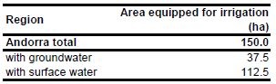
Based on the situation in neighbouring administrative units percentage of AEI irrigated with groundwater was estimated at 25%. It was assumed that AAI is similar to AEI.
References
[AN01]: EEA. 1999. Corine land cover 1990 - vector by country (CLC1990), version 1. http://dataservice.eea.europa.eu/dataservice/metadetails.asp?id=188, 29/08/2005.


