AQUASTAT - FAO's Global Information System on Water and Agriculture
United Arab Emirates
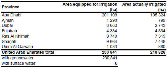
Total cultivated area in year 2003 was 254 918 ha while area equipped for irrigation was 226 600 ha [AE01]. Area equipped for irrigation per emirate was estimated as the difference between total cultivated land and so called shifting area, both reported for year 2003 [AE01]. Total area equipped for irrigation computed this way was 230 841 ha as shown in the table below and in the downloadable United Arab Emirates irrigation areas in PDF or United Arab Emirates irrigation areas in Excel.
The cultivated area of the country, which is completely irrigated, was digitized from Landsat satellite imagery [AE02]. The digitized areas were in good agreement with areas classified as "agricultural areas and plantations" in a recently published atlas [AE03].
Irrigation in the United Arab Emirates is completely based on groundwater [AE01]. Area actually irrigated per emirate was computed as average of cultivated land reported for the period 2006-2008 [AE04]. Total area actually irrigated computed this way was 218 826 ha.
References
[AE01]: FAO. 2013. AQUASTAT country profile of the United Arab Emirates, version 2008. FAO, Rome, Italy.
[AE02]: Earth Satellite Corporation. 2004. Landsat GeoCover (2000/ETM+) Edition Mosaics, tiles 071-309, 071-319 and 071-320. Sioux Falls, USA, USGS, http://glcfapp.umiacs.umd.edu:8080.
[AE03]: United Arab Emirates University. 1993. The national atlas of the United Arab Emirates. Al Ain.
[AE04]: Ministry of Environment and Water. 2013. Agricultural area, quantity and value according to Emirates, versions 2006-2008, http://www.moew.gov.ae/Portal/en/knowledge-and-statistics.aspx#page=1, 20/01/2013.


