AQUASTAT - FAO's Global Information System on Water and Agriculture
Armenia
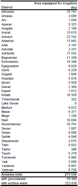
Area equipped for irrigation per district was derived from a cadaster report [AM01] and totals 273 530 ha at the country level, as shown in the table below and in the downloadable Armenia irrigation areas in PDF or Armenia irrigation areas in Excel. The figures are for year 2006.
Irrigated areas were digitized from a map at the scale 1:750 000 [AM02]. The digitized areas have been in good agreement to irrigation schemes shown on other maps, e.g. in [AM03].
Area equipped for irrigation with groundwater was 50 900 ha (18.6 percent of total AEI) in year 2006 while area actually irrigated was 176 000 ha (64.3 percent of total AEI) in the same year [AM04].
References
[AM01]: Ministry of Territorial Administration. 2007. The cadaster of meliorative conditions of irrigated and drained areas of the Republic of Armenia. Ministry of Territorial Administration, State Commity on Water Management, Melioration Organization.
[AM02]: Unknown. Irrigation in Armenia. Map at the scale 1:750 000 available from the AQUASTAT library.
[AM03]: FAO. 1993. Irrigation sub-sector review and project identification. FAO Investment Centre/ World Bank cooperative programme. Report No 79/93 CP - ARM 2. 66p. + 3 annexes.
[AM04]: FAO. 2009. AQUASTAT country profile of Armenia, version 2008. FAO, Rome, Italy.


