AQUASTAT - FAO's Global Information System on Water and Agriculture
Antigua and Barbuda
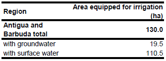
For Antigua and Barbuda no information could be found on irrigated areas on sub-national level. The total area equipped for irrigation is about 130 ha. The figure refers to 1997 [AG01]. The irrigated area is visible in the table below and also can be downloaded as Antigua and Barbuda irrigation areas in PDF or Antigua and Barbuda irrigation areas in Excel.
The irrigated area has been equally distributed to areas, which are classified as cropland according to the USGS Global Land Cover Classification map [AG02].
Area actually irrigated was similar to area equipped for irrigation in year 1997 [AG01]. Surface supplies were reported to be the main source of irrigation water with occasional use of groundwater when municipal demand allows (AG01]). Based on this qualitative information AEI irrigated with groundwater was estimated at 15 percent.
References
[AG01]: FAO. 2000. AQUASTAT country profile of Antigua and Barbuda. FAO, Rome, Italy.
[AG02]: USGS. 2001. Global Land Cover Characterization, map version 2, http://edcdaac.usgs.gov/index.html, 10/08/2006.


