AQUASTAT - FAO's Global Information System on Water and Agriculture
Austria
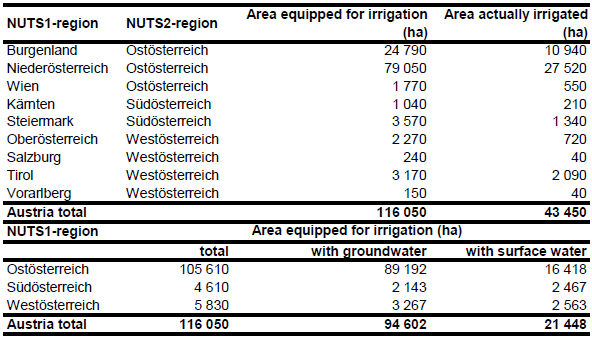
Area equipped for irrigation in NUTS3-regions were derived from the EUROSTAT database [AT01] for year 2007 and further downscaled to municipality level by using data on the percentage of irrigated land provided by an online GIS-service [AT02]. Total AEI computed as sum of the areas reported for the NUTS3-regions is 116 050 ha. The irrigated areas by region are shown in the Table below. The irrigated areas both by region and by municipalities can be downloaded as Austria irrigation areas in PDF or Austria irrigation areas in Excel (two sheets).
Irrigated area was assigned to specific pixels according to the CORINE land cover 2000 database for Europe [AT03]. The highest priority was given to areas classified as non-irrigated arable land, vineyards or complex cultivation patterns. If the extent of these areas was not sufficient, irrigated areas was assigned to areas classified as pastures or land principally occupied by agriculture, with significant areas of natural vegetation.
Area equipped for irrigation with groundwater was computed based on the data collected by the EU farm structure survey 2003 as described before. Area actually irrigated (in total 43 450 ha) per NUTS3-region was derived from the EUROSTAT database [AT01]. The data refer to year 2007.
References
[AT01]: Statistical Office of the European Communities (EUROSTAT). 2011. Irrigable and irrigated areas. http://epp.eurostat.ec.europa.eu/portal/ page/portal/agri_environmental_indicators/data/database, 28/11/2011.
[AT02]: Bundesministerium für Land- und Forstwirtschaft, Umwelt und Wasserwirtschaft. 2008. Geo-Info. Bewässerte Fläche in Prozent der Gemeindefläche. http://gis.lebensministerium.at/geoinfo/, 03/04/2008.
[AT03]: EEA. 2005. Corine land cover 2000 - vector by country (CLC2000), version 1. http://dataservice.eea.europa.eu/dataservice/metadetails.asp?id=667, 29/08/2005.


