AQUASTAT - FAO's Global Information System on Water and Agriculture
Belgium
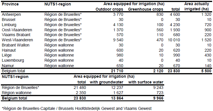
Area equipped for irrigation and area actually irrigated for 11 regions was derived from the statistics of the farm structure survey 2005 [BE01], [BE02]. Total area equipped for irrigation is 23 830 ha, of which 21 710 ha is for irrigated outdoor crops and 2 120 ha for crops in greenhouses. The irrigated area per province and region estimated that way is visible in the table below and also can be downloaded as Belgium irrigation areas in PDF or Belgium irrigation areas in Excel.
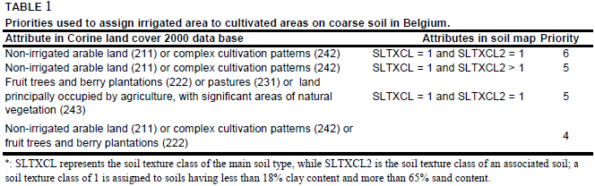
Maps showing the location of irrigation schemes were not available. Area equipped for irrigation was distributed to cultivated land [BE03] in regions of coarse soil [BE04] using priorities in the distribution process as described in Table 1.
Area equipped for irrigation with groundwater was computed based on the data collected by the EU farm structure survey 2003 as described before.
References
[BE01]: Statistical Office of the European Communities (EUROSTAT). 2011. Irrigable and irrigated areas. http://epp.eurostat.ec.europa.eu/portal/page/portal/ agri_environmental_indicators/data/database, 28/11/2011.
[BE02]: Statistical Office of the European Communities (EUROSTAT). 2010. Land use. http://epp.eurostat.ec.europa.eu/portal/page/ portal/agriculture/data/database, 15/07/2010.
[BE03]: EEA. 2005. Corine land cover 2000 - vector by country (CLC2000), version 1. http://dataservice.eea.europa.eu/dataservice/metadetails.asp?id=667, 29/08/2005.
[BE04]: The Commission of the European Communities, Directorate General for Agriculture, Coordination of Agricultural Research. 1985. Soil Map of the European Communities at 1:1 000 000. The Office for Official Publications of the European Communities, ISBN 92-825-5427-9, L-2985 Luxembourg, 124 pages, http://www.grid.unep.ch/data/, 07/07/2006.


