AQUASTAT - FAO's Global Information System on Water and Agriculture
Benin
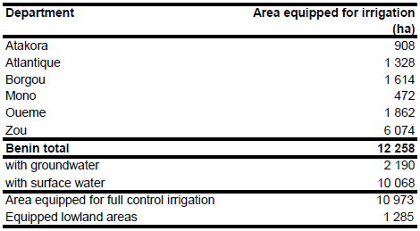
Area equipped for irrigation per department is summing up to 12 258 ha [BJ01]. The figures refer to year 2002 and comprise of 10 973 ha in registered schemes and 1 285 ha of equipped lowland. The irrigated area per department estimated that way is visible in the table below and also can be downloaded as Benin irrigation areas in PDF or Benin irrigation areas in Excel.
The location of 30 full/partial control schemes was digitized from two irrigations maps [BJ02]. The command area of these schemes and the location and extent of 39 other schemes (mainly equipped wetlands) was derived from another report [BJ03]. The command area of these 69 schemes is summing up to 10 621 ha. The remaining part of the formal irrigation and the informal irrigation was assigned to the surrounding of large urban centres as digitized from satellite imagery [BJ04].
20 percent of the area equipped for irrigation in the full/partial control schemes was from groundwater (2 190 ha) [BJ01] while area actually irrigated was 7 131 ha in year 2005 [BJ05].
References
[BJ01]: FAO. 2005. AQUASTAT country profile Benin. FAO, Rome, Italy.
[BJ02]: Republique du Benin. 1994. Statistique sur l'hydraulique agricole et rurale – Donnees de base et cartes. 30 pp. Report available in the AQUASTAT-library.
[BJ03]: FAO. 2003. AQUASTAT – Benin. Enquete sur l'utilisation de l'eau pour l'agriculture et le development rural au Benin. Rapport General. Report available in the AQUASTAT-library.
[BJ04]: Earth Satellite Corporation. 2004. Landsat GeoCover (2000/ETM+) Edition Mosaics, tiles 071-202 and 071-203. Sioux Falls, USA, USGS (available at http://glcfapp.umiacs.umd.edu:8080).
[BJ05]: Gruber, I., Kloos, J., and Schopp, M. 2009. Seasonal water demand in Benin’s agriculture. Journal of Environmental Management 90, 196-205.


