AQUASTAT - FAO's Global Information System on Water and Agriculture
Bulgaria
The area equipped for irrigation was 1 288 000 ha in 1990 [BG01] but declined later to 673 000 ha in 1995 [BG02] and 545 160 ha in 2003 [BG03]. Even stronger was the decline in the area actually used for irrigation. While in 1985 about 1 014 000 ha of cultivated land was irrigated the area actually irrigated declined to 842 000 ha in 1989 [BG01], to about 100 000 ha in the period 1992-1996 [BG02] and to about 40 000 ha nowadays [BG04]. Large parts of the irrigation infrastructure constructed before 1990 deteriorated because of the break up of large farms and the lack of finance for restructuring irrigation systems to meet the needs of small farmers [BG05]. The restructuring of the irrigation sector makes it difficult to estimate the area equipped for irrigation. The equipment at the former pumping stations is missing almost everywhere and a significant part of the canals is destroyed [BG04]. Thus it depends on the definitions used whether areas are still classified as equipped for irrigation or not and one can find different numbers for the extent of irrigated areas in the statistics. EUROSTAT for example reported for 2003 an irrigable area of 124 490 ha and an area actually irrigated of 79 370 ha [BG06]. In 2002 the hydraulic infrastructure for 537 558 ha irrigated land in 235 irrigation systems was managed by the Irrigation Systems Co. (ISC) and 3 351 ha in five systems by the Hydro-melioratzii Ltd. Sevlievo (HMS). Both are trade companies. In contrast 4 251 ha were managed by newly created irrigation associations [BG03]. Area equipped for irrigation per branch of the ISC was derived from [BG03]. The irrigated area estimated that way is visible in the table below and also can be downloaded as Bulgaria irrigation areas in PDF or Bulgaria irrigation areas in Excel.
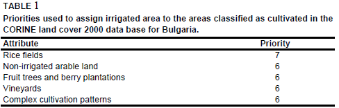
The outlines of the major irrigation areas of the country were digitized from an irrigation map published in [BG01] to distribute irrigated areas within the branches of the ISC. Irrigated area was assigned to all polygons of the Corine land cover 2000 data base [BG07] that were located within the digitized irrigation areas and that were classified as non-irrigated arable land (211), rice fields (213), vineyards (221), fruit trees and berry plantations (222) or complex cultivation patterns (242) using priority levels shown in Table 1.
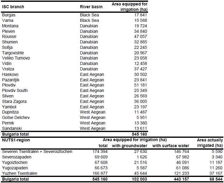
Area actually irrigated for 5 regions was computed as average of the AAI reported in the EU farm structure surveys 2003, 2005 and 2007 [BG06]. Total AAI computed that way was 68 544 ha.
References
[BG01]: FAO. 1991. Bulgaria. Irrigation subsector review. FAO Investment Centre, Report No: 109/91 CP-BUL 2, Rome, Italy.
[BG02]: Öko Inc. Budapest. 2001. Agricultural water management policies in Bulgaria, Hungary, Romania and Slovakia. Final report. Budapest, Hungary, 35 pp.
[BG03]: Ministry of Agriculture and Forestry. 2004. Rural development project. Study on irrigation tariffs and subsidy. Sofia, Bulgaria, 63 pp., http://www.mzgar.government.bg/, 07/07/2006.
[BG04]: Chehlarova-Simeonova, S., Yusuf, S., Florov, V. and Ninova, M. 2006. Country report from Bulgaria. In: Dirksen, W. and Huppert, W. (ed.). Irrigation sector reform in Central and Eastern European countries. Deutsche Gesellschaft für Technische Zusammenarbeit (GTZ), Eschborn, Germany, 41-102.
[BG05]: World Bank. 2003. Water resources management in South Eastern Europe. Vol. II - Country water notes and water fact sheets. Washington, United States, http://www-wds.worldbank.org/, 07/07/2006.
[BG06]: Statistical Office of the European Communities (EUROSTAT). 2011. Irrigable and irrigated areas. http://epp.eurostat.ec.europa.eu/portal/ page/portal/agri_environmental_indicators/data/ database, 28/11/2011.
[BG07]: EEA. 2005. Corine land cover 2000 - vector by country (CLC2000), version 1. http://dataservice.eea.europa.eu/dataservice/metadetails.asp?id=667, 29/08/2005.


