AQUASTAT - FAO's Global Information System on Water and Agriculture
Bahrain
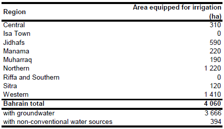
The cultivated area increased between 1993 and 2000 from 3 160 ha to more than 4 000 ha [BH01] and it is completely equipped for irrigation. Irrigated area reported for 9 regions adds up to 4 060 ha [BH02]. The figures refer to the year 2001. The irrigated area per region estimated that way is visible in the table below and also can be downloaded as Bahrain irrigation areas in PDF or Bahrain irrigation areas in Excel.
The location of irrigated areas was detected using a land-use map [BH03] showing the cultivated areas of the country. The irrigated areas were then digitized in detail from Landsat satellite imagery [BH04].
Because of the arid climate and limited surface water supply, irrigation water withdrawal is mainly from groundwater. Area equipped for irrigation with groundwater is 90.3 percent of total AEI [BH05], while the remaining 394 ha are irrigated with non-conventional water sources.
References
[BH01]: Government of Bahrain. 2004. Statistical abstracts 2002. Table S20B, http://www.bahrain.gov.bh, 19/07/2004.
[BH02]: Arab Organization for Agricultural Development. 2003. Arab Agricultural Statistics Yearbook 2002. Agricultural Information, Documentation and Statistics Center, http://www.aoad.org, 19/07/2004.
[BH03]: Statistisches Bundesamt. 1991. Länderbericht Bahrain 1991. Wiesbaden, Germany.
[BH04]: Earth Satellite Corporation. 2004. Landsat GeoCover (2000/ETM+) Edition Mosaics, tile 071-310. Sioux Falls, USA, USGS, http://glcfapp.umiacs.umd.edu:8080.
[BH05]: FAO. 2009. AQUASTAT country profile of Bahrain, version 2008. FAO, Rome, Italy.


