AQUASTAT - FAO's Global Information System on Water and Agriculture
Bhutan
Area equipped for irrigation is 27 685 ha [BT01]. The statistics refer to “wetlands” which is the local term for irrigated land [BT02]. Area equipped for irrigation is reported for 20 provinces (dzongkhag) and the statistics refer to year 2007.The irrigated area per province is visible in the table below and also can be downloaded as Bhutan irrigation areas in PDF or Bhutan irrigation areas in Excel.
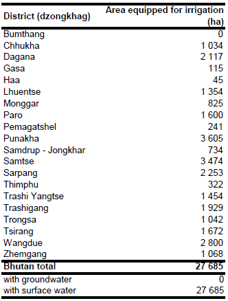
The irrigated areas were digitized from a land use atlas with a scale of 1 : 250 000 [BT03].
The whole area equipped for irrigation is irrigated by using surface water sources [BT02].
References
[BT01]: National Statistics Bureau (NSB). 2009. Statistical Yearbook of Bhutan 2009. NSB, Royal Government of Bhutan, Thimphu, http://www.nsb.gov.bt/pub/syb/syb2009.pdf, 10/04/2012.
[BT02]: FAO. 2011. AQUASTAT country profile of Bhutan, version 2010. FAO, Rome, Italy.
[BT03]: Ministry of Agriculture. 1997. Atlas of Bhutan 1 : 250 000, land cover & area statistics of 20 Dzongkhags. Thimphu, Land Use Planning Project.


