AQUASTAT - FAO's Global Information System on Water and Agriculture
Côte d'Ivoire
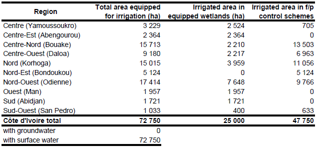
Area equipped for irrigation is 72 750 ha. The figures refer to year 1994. Area in full/partial control areas is reported to be 47 750 ha while equipped wetlands cover 25 000 ha [CI01]. Equipped wetland as reported by the statistics for 10 regions [CI02] was 24 940 ha. The total area of 44 known irrigation schemes derived from the AQUASTAT irrigation project database [CI03] and from another irrigation map [CI04] is 39 605 ha and was also assigned to the 10 regions depending on the location of the schemes. To compute total area equipped for irrigation the figures per region were scaled to meet the country-totals of full/partial control area and the equipped wetland area respectively. The irrigated area per region estimated that way is visible in the table below and also can be downloaded as Côte d'Ivoire irrigation areas in PDF or Côte d'Ivoire irrigation areas in Excel.
Irrigated area was distributed to the 44 known projects. The outlines of the five largest schemes (total command area of these schemes is 30 000 ha) were then adjusted using satellite imagery [CI05]. The satellite images were also used to digitize cultivated areas along the main rivers and in lowlands. The remaining irrigated area was distributed to those digitized areas.
Area actually irrigated was 66 930 ha in year 1994 and completely by using surface water sources [CI01].
References
[CI01]: FAO. 2005. AQUASTAT country profile Cote D'Ivoire, FAO, Rome, Italy.
[CI02]: FAO. 1999. Côte d’Ivoire – Éléments de stratégie nationale de développement de la petite irrigation et plan d’action opérationel. Document de travail 3: Valorisation de la production agricole.
[CI03]: FAO. 1987 (updated in 2005). Irrigated areas in Africa. FAO, Rome, Italy.
[CI04]: Universite Nationale de Côte d’Ivoire. 1988. Atlas regional du Nord-Est de la Côte d’Ivoire. Planche 24 (operations agricole).
[CI05]: Earth Satellite Corporation. 2004. Landsat GeoCover (2000/ETM+) Edition Mosaics, tiles 071-176, 071-177, 071-178, 071-188, 071-189 and 071-190. Sioux Falls, USA, USGS (available at http://glcfapp.umiacs.umd.edu:8080).


