AQUASTAT - FAO's Global Information System on Water and Agriculture
Cameroon
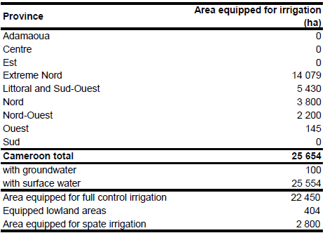
Area equipped for irrigation is reported to be 25 654 ha, of which 22 450 ha is in full/partial control schemes, 404 ha in equipped wetlands and 2 800 ha in spate irrigation. The figures refer to year 2000. Irrigated area per province was computed as the sum of the command areas of irrigation projects mentioned in the AQUASTAT-country profile [CM01]. The irrigated area per province estimated that way is visible in the table below and also can be downloaded as Cameroon irrigation areas in PDF or Cameroon irrigation areas in Excel.
The command area and position of seven irrigation projects was derived from the FAO irrigation map for Africa [CM02]. The total area equipped for irrigation of these schemes is 17 270 ha. The outlines of five schemes larger than 1 000 ha were adjusted using satellite imagery [CM03]. According to the statements in the country profile [CM01] there are about 1 000 ha irrigated area close to the Lagdo reservoir. The outlines of the scheme were digitized from satellite imagery [CM03]. Cultivated land in the surrounding of Garoua and in the provinces of Littoral and Sud-Ouest representing spate irrigation areas or banana plantations was digitized as well.
Irrigation in formal irrigation is completely from surface water resources [CM01] while farmers in small informal peri-urban irrigation around Yaounde also use groundwater from shallow wells [CM04]. Area equipped for irrigation with groundwater was therefore estimated at 100 ha. Area actually irrigated was assumed to be similar to area equipped for irrigation because harvested area of irrigated crops in year 2000 was much larger (at least 44 540 ha) than area equipped for irrigation indicating a high cropping intensity on irrigated land [CM01].
References
[CM01]: FAO. 2005. AQUASTAT country profile Cameroon. FAO, Rome, Italy.
[CM02]: FAO. 1987 (updated in 2005). Irrigated areas in Africa. FAO, Rome, Italy.
[CM03]: Earth Satellite Corporation. 2004. Landsat GeoCover (2000/ETM+) Edition Mosaics, tiles 071-213, 071-214, 071-227, 071-228 and 071-229. Sioux Falls, USA, USGS (available at http://glcfapp.umiacs.umd.edu:8080).
[CM04]:Drechsel, P., Graefe, S., Sonou, M., Cofie, O. 2006. Informal irrigation in urban West Africa: an overview. Research Report 102, International Water Management Institute (IWMI), Colombo, Sri Lanka, http://www.iwmi.cgiar.org/Publications/IWMI\_Research\_Reports/ index.aspx , 19/08/2009.


