AQUASTAT - FAO's Global Information System on Water and Agriculture
Colombia
The area equipped for irrigation in Colombia is about 900 000 ha [CO01]. AEI per province was computed based on the maximum of AEI reported per province in two studies in the AQUASTAT-library referring to years 1992 and 1997. The irrigated area in these studies adds up to 870 000 ha and was scaled to meet the AQUASTAT country value for 1998. The irrigated area per province estimated that way is visible in the table below and also can be downloaded as Colombia irrigation areas in PDF or Colombia irrigation areas in Excel.
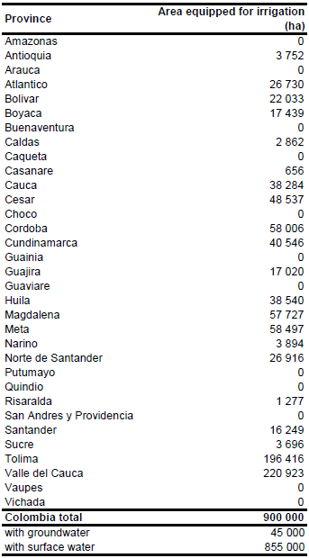
Areas of high irrigation density can be found in an interior valley which covers the provinces Valle del Cauca and Tolima and in the northwestern provinces. Location and extent of 528 public irrigation districts with a total AEI of 361 218 ha was extracted from a digital data set ([CO02]). Additionally, irrigation areas and the location of irrigation projects were digitized from several maps ([CO03], [CO04], [CO05]).
Very little information has been available regarding the source of water used for irrigation. The available data indicate that surface water from rivers, reservoirs and lakes is by far the major source of irrigation water. In the inventory of public irrigation districts ([CO02]) only surface water sources (streams, lakes, reservoirs, and lagoons) were indicated. An inventory of wells per hydro-geological zone shows that only in the major irrigation areas along the Magdalena and Cauca Rivers and in the surrounding of Bogota there is a significant number of wells used for irrigation (Leyva, 2001). Based on this indicative information and also considering the situation in neighbouring countries, percentage of AEI irrigated with groundwater was estimated at 5 percent.
References
[CO01]: FAO. 2000. AQUASTAT country profile of Colombia. FAO, Rome, Italy.
[CO02]: Instituto Geográfico Agustín Codazzi (IGAC). 2007. Distritos de Riego. República de Colombia. Año 2007. Instituto Geográfico Agustín Codazzi (IGAC), Subdirección de Geografía, División de Ordenamiento Territorial, http://sigotn.igac.gov.co/sigotn/default.aspx, 17/12/2010.
[CO03]: INAT. 1999. Map of medium and large irrigation schemes. INAT, Subdireccion de Planeacion e Informatica.
[CO04]: Atlas de Colombia. 1998. Mapa de los Distritos de Riego de la Republica de Colombia.
[CO05]: CIAT. 1997. Distribution of rice in Latin America, http://www.gis.ciat.cgiar.org or http://www.grida.no/prog/global/cgiar/.
[CO06]: Leyva, P. (ed.). 2001. El medio ambiente en Colombia. 2nd edition, Instituto de Hidrología, Meteorología y Estudios Ambientales (IDEAM), Bogota, Colombia, http://www.ideam.gov.co/publica/index4.htm, 16/08/2009.


